Printable Version of Topic
Click here to view this topic in its original format
Unmanned Spaceflight.com _ Juno _ Ganymede Flyby - PJ34
Posted by: volcanopele May 7 2021, 06:41 PM
Now that we are a month out from the Ganymede encounter, I'm creating a special thread just for this encounter.
A few basic facts about the encounter:
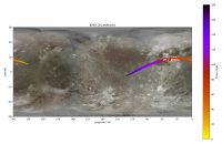
The encounter takes place June 7, 2021 at 16:56:07.972 UTC at an altitude of 1042 km from Ganymede's surface. The central latitude and longitude of the close approach point is 23.58 N, 57.62 W. The inbound leg occurs over Ganymede's nightside while the outbound leg covers the dayside, allowing for imaging of Ganymede's leading and sub-Jovian hemispheres.
|
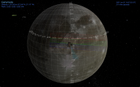
The best imaging opportunities occur after closest approach, with dayside imaging possible between +00:15 and +06:45 at distances between 1050 km and 5690 km above Ganymede's surface (though the first pass will be along the terminator and the last pass will only capture a bit of the bright limb). This allows for JunoCAM images with resolutions between 0.71 and 3.82 km. The best imaging opportunity in my opinion is centered at +01:45 when Juno is 1,515 km above Ganymede. This allows for imaging at around 1 km/pixel, doesn't cover the terminator or too much of the limb, and allows for detailed imaging of Perrine Regio and Tros crater, a prominent ray crater within Phrygia Sulcus. A Cosmographia screen shot of the center time for this pass is below.
|
I've updated my simulation video of the encounter, now making use of updated trajectory and now has real orientation information.
https://www.youtube.com/watch?v=H_UO3EFB6l0
Posted by: MarcF May 14 2021, 10:47 AM
If I'm correct, the highest resolution pictures should be taken at low sun angle, so I expect spectacular scenes. Especially, we will be able to see details of the topography of Tros crater, one of the youngest craters on Ganymede. Can't wait.
Posted by: Brian Swift May 15 2021, 04:15 PM
Mike, any chance you can share preliminary/(final?) junocam commanding parameters for Ganymede encounter?
I'm checking out my pipeline and would rather use your commands than make up my own.
Tangentially related... typically, when is the deadline for delivering commands for uplink to Juno for a perijove?
Posted by: TrappistPlanets May 18 2021, 11:57 AM

A few basic facts about the encounter:
The encounter takes place June 7, 2021 at 16:56:07.972 UTC at an altitude of 1042 km from Ganymede's surface. The central latitude and longitude of the close approach point is 23.58 N, 57.62 W. The inbound leg occurs over Ganymede's nightside while the outbound leg covers the dayside, allowing for imaging of Ganymede's leading and sub-Jovian hemispheres.
|
|
The best imaging opportunities occur after closest approach, with dayside imaging possible between +00:15 and +06:45 at distances between 1050 km and 5690 km above Ganymede's surface (though the first pass will be along the terminator and the last pass will only capture a bit of the bright limb). This allows for JunoCAM images with resolutions between 0.71 and 3.82 km. The best imaging opportunity in my opinion is centered at +01:45 when Juno is 1,515 km above Ganymede. This allows for imaging at around 1 km/pixel, doesn't cover the terminator or too much of the limb, and allows for detailed imaging of Perrine Regio and Tros crater, a prominent ray crater within Phrygia Sulcus. A Cosmographia screen shot of the center time for this pass is below.
|
|
I've updated my simulation video of the encounter, now making use of updated trajectory and now has real orientation information.
https://www.youtube.com/watch?v=H_UO3EFB6l0
so will we get any new map coverage (like the poles)?
and will we get any good stereo DEMS from the encounter?
i want more complete ganymede DEMs then just tiny chunks
nice video
only if juno had a ganymede and europa lander, we could land something on those 2 moons like cassini and huygens, but juno's original mission was to study jupiter witch needs no landers because jupiter is a gas planet
we need landers to go on ganymede and europa some day
Posted by: Antdoghalo May 18 2021, 01:38 PM
No to the pole coverage but yes to the color imagery and yes to improving resolution in some areas. It is likely stereo coverage will allow some DEM's to be made of this region eventually.
Posted by: TrappistPlanets May 19 2021, 04:04 PM
wait juno can take stereo (3d) imagery, or do you need 2 different view of the same spot to make a stereo image for a DEM?
how reliable would the DEMS of that area of ganymede be that juno saw (according to the video simulation)?
the region that i am curious about elevation (perrine regio area) is in fact going to be clearly visible during the juno flyby (according to video)
Posted by: volcanopele May 19 2021, 04:20 PM
The issue isn't coverage or even viewing angles, the issue will be resolution. The best resolution images will be at ~0.7 km/pixel, and some of the best images will be closer to 12 km/pixel. Whether there is enough topography for that scale to be useful is a good question.
Posted by: mcaplinger May 19 2021, 09:42 PM
Sorry, no, because of the way we command these the details go outside the boundaries of the Junocam team.
Jason's animation gives you a good flavor of the likely timing, but of course the spacecraft spin phasing cannot be predicted in advance with any accuracy. We are almost certainly not going to try any imaging of the nightside because of time and data volume constraints. In rough terms, imaging will start around 16:57:30 +/- 15s and continue at 1-minute cadence for a while (TBD just how long, Ganymede leaves the field by 17:03:30 or so anyway but there are other constraints.)
FWIW, the kernels on the public NAIF site are the same ones we use.
Posted by: JohnVV May 20 2021, 01:05 AM
for those that do not have these bookmarked already
the public orbital kernels are here
ftp://naif.jpl.nasa.gov/pub/naif/JUNO/kernels/spk/
and the rotational kernels are here
ftp://naif.jpl.nasa.gov/pub/naif/JUNO/kernels/ck/
you will also need other kernels like the framing one and the leap-second to do any spice calculations
ftp://naif.jpl.nasa.gov/pub/naif/JUNO/kernels/fk/
ftp://naif.jpl.nasa.gov/pub/naif/JUNO/kernels/lsk/
Posted by: Brian Swift May 20 2021, 06:43 AM
Jason's animation gives you a good flavor of the likely timing, but of course the spacecraft spin phasing cannot be predicted in advance with any accuracy. We are almost certainly not going to try any imaging of the nightside because of time and data volume constraints. In rough terms, imaging will start around 16:57:30 +/- 15s and continue at 1-minute cadence for a while (TBD just how long, Ganymede leaves the field by 17:03:30 or so anyway but there are other constraints.)
FWIW, the kernels on the public NAIF site are the same ones we use.
Thanks Mike. I'm lazy. Didn't want to knock out an encounter planner if you already had the numbers available.
So, are you saying the plan is to collect a series of full spin images, with spin phasing hopefully known well enough to keep Ganymede off the start/end seam?
For Jupiter images, does flight software (realtime attitude) determine image start times?
Should we expect TDI=1?
I haven't run the numbers yet, do you know if motion blur is going to be particularly bad?
Posted by: mcaplinger May 21 2021, 03:27 AM
That would not be possible, because it takes a lot longer than a spin to read out a full spin of data (over two minutes, in fact.)
One might assume that whatever magical process we used for, say, the PJ29 images of Ganymede (10 frames more or less centered on Ganymede) might be employed here in some form, but alas, I can't describe the details.
Posted by: Brian Swift May 25 2021, 05:14 AM
Is this due to information being MSSS proprietary, or something that is going into a future publication, or ITAR spacecraft commanding concerns, or something else?
Can you comment on how INTERFRAME_DELAY is determined?
Also, do you know if there is going to be a post-Ganymede encounter press conference? And if there is, if "they" (the powers that be)
are considering holding back the raw images until after the press conference?
Posted by: mcaplinger May 26 2021, 02:10 AM
I've already said as much as I can for reasons I cite upthread. It's certainly neither of the first two.
It can be directly commanded or it can be computed onboard based on spacecraft attitude knowledge (this is described in the Junocam paper so I feel OK saying that.) It would be an interesting exercise to compare the actual attitude in the reconstructed C kernels to that in the predicted C kernels, as that would give you a sense of how well this is known in advance.
If there is, no one has told me about it. https://en.wikipedia.org/wiki/Loaded_question
I will say that many people have done a lot of work over the past few months planning this sequence. It would have been less stressful to start with a more distant encounter, but we'll see how it goes.
Posted by: volcanopele May 26 2021, 06:16 PM
Just think of this and the Europa flyby as dress rehearsals for the Io flybys

Posted by: Brian Swift May 28 2021, 07:56 AM
Understood Mike. Thanks for the response. Checking on value of INTERFRAME_DELAY for past few perijoves, looks like it is almost always .370, so I just use that as a fixed value.
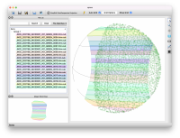
Here is a visualization of what I think the imaging opportunities are for the PJ34 Ganymede encounter.
It was produced by running a raw data test pattern image through my pipeline using metadata generated
based on the SPICE available 5/26. (Hopefully I don't have the wrong side of Ganymede illuminated or
something upside-down.) https://youtu.be/SzHtDbhAF7E
Table of timings for my data takes which include one frame of padding at beginning and end.
P34_9001 to P34_9005 are on dark side.
P34_9021 didn't produce any imagery on the target even though the encounter planner thinks it should see 7 degrees of the limb.
imageId START_TIME STOP_TIME duration totalFrames limbPoints terminatorPoints
P34_9001 2021-06-07T16:53:19.678 2021-06-07T16:53:25.968 6.29 17 92 0
P34_9002 2021-06-07T16:53:48.459 2021-06-07T16:53:56.599 8.14 22 143 0
P34_9003 2021-06-07T16:54:17.627 2021-06-07T16:54:27.247 9.62 26 185 0
P34_9004 2021-06-07T16:54:47.170 2021-06-07T16:54:57.530 10.36 28 207 0
P34_9005 2021-06-07T16:55:17.088 2021-06-07T16:55:27.448 10.36 28 218 0
P34_9006 2021-06-07T16:55:47.014 2021-06-07T16:55:57.374 10.36 28 240 21
P34_9007 2021-06-07T16:56:16.943 2021-06-07T16:56:26.933 9.99 27 233 99
P34_9008 2021-06-07T16:56:47.252 2021-06-07T16:56:56.872 9.62 26 216 102
P34_9009 2021-06-07T16:57:17.568 2021-06-07T16:57:26.448 8.88 24 212 105
P34_9010 2021-06-07T16:57:47.521 2021-06-07T16:57:56.401 8.88 24 254 61
P34_9011 2021-06-07T16:58:17.857 2021-06-07T16:58:26.367 8.51 23 271 27
P34_9012 2021-06-07T16:58:47.822 2021-06-07T16:58:55.962 8.14 22 250 8
P34_9013 2021-06-07T16:59:17.795 2021-06-07T16:59:25.935 8.14 22 237 0
P34_9014 2021-06-07T16:59:48.146 2021-06-07T16:59:55.546 7.4 20 215 0
P34_9015 2021-06-07T17:00:18.127 2021-06-07T17:00:25.527 7.4 20 205 0
P34_9016 2021-06-07T17:00:48.478 2021-06-07T17:00:55.138 6.66 18 182 0
P34_9017 2021-06-07T17:01:18.837 2021-06-07T17:01:25.127 6.29 17 167 0
P34_9018 2021-06-07T17:01:48.822 2021-06-07T17:01:54.742 5.92 16 145 0
P34_9019 2021-06-07T17:02:19.185 2021-06-07T17:02:24.365 5.18 14 111 0
P34_9020 2021-06-07T17:02:49.915 2021-06-07T17:02:53.985 4.07 11 83 0
P34_9021 2021-06-07T17:03:20.650 2021-06-07T17:03:23.240 2.59 7 25 0
Posted by: mcaplinger May 29 2021, 06:37 PM
We will be releasing the PJ34 data per our usual process. Recall that we can't release standard products until we get the reconstructed C kernel, and we don't release partial images until every effort has been made to retransmit them. For the Ganymede imaging, we'll be trying to generate the map-projected standard products but it's not clear how well that will work (may be sensitive to SPK errors or our software might just choke); if it doesn't work then we will just release the raw products.
All that adds up to the data showing up on missionjuno no earlier than 8 June and hopefully no later than the day after, barring unanticipated events. And note that I haven't looked at the specifics of the DSN schedule so I'm not sure when the raw data is expected on the ground.
In theory we could post the raw data without waiting for the C kernel, but that would be outside our normal flow and might preclude ever posting the map-projected images if they do work, so I wouldn't count on it for now.
Posted by: mcaplinger May 29 2021, 06:41 PM
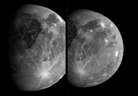
My simulations of the first two Ganymede images, subject to spin phase and timing/nav errors.
|
Posted by: Brian Swift May 31 2021, 05:35 AM
Thanks for the update Mike. I assume everyone is pretty excited about the Ganymede encounter, I certainly am.
Glad to hear the plan is for a normal data release. (Though I can certainly understand projects wanting to be more restrictive to maximize a news-cycle impact.)
Looks like my mapping images are consistent with youre simulated images, so at least I dont have the illumination coming from the opposite direction.
Can you say if the Ganymede images will be less compressed than typical Jupiter images given their novelty.
Posted by: mcaplinger May 31 2021, 03:14 PM
As with many high-value Jupiter images, the plan is to take the Ganymede images with lossless compression.
We always compress at as high a quality factor as we can given the goals and constraints of each PJ pass.
Posted by: Steve G May 31 2021, 08:50 PM
Would have any of these flybys been possible had Juno successfully completed the Period Reduction Maneuverer to the nominal 14 day science orbit, assuming an extended mission was granted?
Posted by: Explorer1 May 31 2021, 09:14 PM
An interesting what-if, but the increased radiation damage taken during those orbits makes it hard to be certain. Funny to think the mission might already have been over by now but for the engine problems!
Posted by: mcaplinger May 31 2021, 11:34 PM
No idea, it depends mostly on the delta V required to trim the orbit. I didn't have the impression that it took that much delta V but I could be mistaken.
AFAIK the dose per orbit is not much different between the 53-day orbit and the 14-day orbit, you just accumulate it faster with the shorter orbit. There's no way to know how the nominal mission with the PRM would have gone.
Posted by: stevesliva Jun 1 2021, 12:41 PM
https://spaceflightnow.com/2020/10/12/juno-team-planning-close-flybys-of-jupiters-moons/
Note: not a direct quote from Bolton; author's words.
Posted by: Decepticon Jun 5 2021, 04:57 AM
https://www.nasa.gov/feature/jpl/nasa-s-juno-to-get-a-close-look-at-jupiter-s-moon-ganymede
Posted by: vjkane Jun 5 2021, 02:32 PM
Note: not a direct quote from Bolton; author's words.
I heard Bolton say equivalent words in meetings.
Posted by: Steve G Jun 5 2021, 03:14 PM
Ganymede is the only large moon with the exception of Iapetus that has significant albedo variations like Earth's moon. Even Mercury is relatively bland. It is a fascinating world, and I'm looking forward to the results that I am certain will be fascinating.
Posted by: TrappistPlanets Jun 6 2021, 03:56 PM
|
|
i want to make a mosaic from the real images when we get them tomorrow, but how am i going to fix the distortions as seen in your simulation of 2 of the pics?
Posted by: mcaplinger Jun 6 2021, 06:27 PM
There's nothing different about the Ganymede images and they have to be processed the same way as any other Junocam image.
The simulation was just a rough stitch of the simulated frames with the overlap removed and doesn't closely resemble either the real raw data or our map projections.
As discussed above, the earliest you can expect the data on missionjuno is sometime on Tuesday 8 June. I honestly don't know if playback will be happening between the Ganymede encounter and the perijove pass (I hope so), but checking https://eyes.nasa.gov/dsn/dsn.html to see if there is high-rate downlink from Juno will be a clue.
Posted by: JRehling Jun 7 2021, 04:31 PM
In all the excitement about visual images of Ganymede, I lost track of how Juno's main instruments will provide at least four new (or best-yet) kinds of science regarding Ganymede, taking surface spectroscopy in new wavelengths and doing some subsurfacing microwave sounding, which is a big deal penetrating the ice of a jovian moon is a major goal for Europa in particular and Juno will be the first opportunity to do so, first getting data from Ganymede and then, hopefully, differential data that is comparable at Europa. Finally, occultation of radio signals is not something new but 2021 technology is an advance over Galileo results; moreover, with the variable nature of Jupiter's and Ganymede's particles and fields environments, more data at new lat-lon locations is always valuable.
That data won't all be analyzed this week, but should be available eventually if the encounter goes well.
Posted by: Antdoghalo Jun 7 2021, 04:50 PM
NASA's Eyes show flyby happening right now.
Posted by: TrappistPlanets Jun 7 2021, 05:42 PM
mcaplinger,
many juno jupiter images look like this https://earthsky.org/upl/2020/03/jupiter-perijove25-e1583360265305.png, and that is a lot of distortion to fix
juno did fly close enough for some of that to be happening
Posted by: mcaplinger Jun 7 2021, 06:30 PM
and that is a lot of distortion to fix
I'm not sure I'd call that distortion, when you fly close to something that's roundish you're pretty much stuck with a view like that.
I think you should simply wait for the data and then see what you and others can do with it.
Posted by: Kevin Gill Jun 7 2021, 11:40 PM
many juno jupiter images look like this https://earthsky.org/upl/2020/03/jupiter-perijove25-e1583360265305.png, and that is a lot of distortion to fix
juno did fly close enough for some of that to be happening
Those images are composites of multiple images and are intentionally reprojected by me (in this case) into a simulated Fisheye Equisolid lens ("Little Planet" effect). From some of the simulated images, it doesn't look like Juno flew so close to Ganymede where this effect would be so pronounced
Posted by: TrappistPlanets Jun 8 2021, 12:56 AM
so i should be able to reproject the Ganymede images one we get them tomorrow morning (my time zone) with little to no distortion related issues as long i know where the poles and the equator is located and the angle/axis of the object in the images?
Posted by: Hungry4info Jun 8 2021, 01:18 AM
It depends on the level of imagery you're using. The raw data has significant distortions caused by the motion of the spacecraft, but certainly people here will be able to re-project them correctly.
Posted by: Steve5304 Jun 8 2021, 02:47 AM
ETA on imagery?
Posted by: djellison Jun 8 2021, 03:22 AM
You are talking about push frame images from a spinning spacecraft travelling at 19km/sec just 1,038km from the surface that will have moved nearly 600km in a single rotation.
It's nothing BUT distortion related issues.
The images will be here when they're here.
Some of the gurus of Junocam work will figure out some nice reprojections I'm sure.
Posted by: mcaplinger Jun 8 2021, 03:33 AM
Per post #16 in this thread: "All that adds up to the data showing up on missionjuno no earlier than 8 June and hopefully no later than the day after".
Posted by: JRehling Jun 8 2021, 03:49 AM
Ganymede, in regional views, gives us one thing that Jupiter doesn't a bonanza of well-known control points that have already been identified. Even without knowing a bit about the motion of Juno, it seems that someone could stretch and fit whatever images we get to existing maps.
Posted by: nprev Jun 8 2021, 04:12 AM
ADMIN MODE: The ETA on end of tolerance for people badgering others about this flyby has long since passed. In fact it's passed for badgering of ALL kinds.
Stop. Now. Right now.
/ADMIN MODE
Posted by: antipode Jun 8 2021, 06:24 AM
While we are waiting, I think this is timely and relevant, for this encounter and certainly for JUICE.
Is it a collisional atmosphere? Maybe some of the time, in some places?
https://arxiv.org/pdf/2106.03570.pdf
P
Posted by: Ian R Jun 8 2021, 09:26 AM
Goldstone is currently receiving a downlink from Juno.
Posted by: TrappistPlanets Jun 8 2021, 11:07 AM
can't wait to see juno's new images of ganymede
what rayleighs did juno image ganymede in during the flyby?
Posted by: TrappistPlanets Jun 8 2021, 11:11 AM
yeah, Ganymede is so well mapped that if you know enough or seen enough already existing Ganymede maps, you can easily recognize a curtain crater or fault
as for Jupiter, it changes so much that you struggle to tell what the offset of that particular image should be after you reproject it...
Posted by: owlsyme Jun 8 2021, 01:18 PM
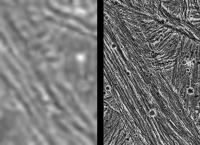
Here's a comparison with Voyager and Galileo images -
|
The frame at left was taken by the Voyager 2 spacecraft when it flew by in 1979, with a resolution of about 1.3 kilometers (0.8 mile) per pixel. The frame at right showing the same area was captured by Galileo during its first flyby of Ganymede on June 27, 1996; it has a resolution of about 74 meters (243 feet) per pixel, more than 17 times better than that of the Voyager image.
https://www.jpl.nasa.gov/images/ganymede-comparison-of-voyager-and-galileo-resolution
Posted by: HSchirmer Jun 8 2021, 05:43 PM
NASA should have gotten the full transmission by now?
Still talking to Canberra dish.
https://eyes.nasa.gov/dsn/dsn.html
Going to be quite busy, 3 Mars rovers, Juno, New Horizons, and 2 Voyagers.
(I'm assuming the Chinese rover uses the DSN, rather than their own dish?)

|
Posted by: TrappistPlanets Jun 8 2021, 05:46 PM
https://eyes.nasa.gov/dsn/dsn.html
Going to be quite busy, 3 Mars rovers, Juno, New Horizons, and 2 Voyagers.
(I'm assuming the Chinese rover uses the DSN, rather than their own dish?)
i have just found this image from the juno flyby https://www.nasa.gov/image-feature/jpl/juno-s-ganymede-close-up
now hm.... how am i going to work with this to turn that into a map, i think i can figure that out myself...
Posted by: mcaplinger Jun 8 2021, 05:54 PM
I've tried to be very patient (the mods can attest to the fact that I haven't complained about any post on this thread), but people are just not getting what I am saying, apparently.
We are working through some issues with our processing and I hope the images will be showing up on missionjuno shortly. In the meantime enjoy the quicklook product that NASA released.
Posted by: Marcin600 Jun 8 2021, 05:57 PM
We are working through some issues with our processing and I hope the images will be showing up on missionjuno shortly. In the meantime enjoy the quicklook product that NASA released.
Wonderful photos!!! Thank you!!!
Posted by: Explorer1 Jun 8 2021, 06:13 PM
Boom!
https://www.jpl.nasa.gov/news/see-the-first-images-nasas-juno-took-as-it-sailed-by-ganymede
Posted by: Julius Jun 8 2021, 06:16 PM
Ganymede is a planet in its own right. An iron core and silicate mantle topped by an icy crust which is partly fluid. An.internal heat source which generates a magnetic field. The surface exhibits tectonic activity possibly still ongoing. I wonder the source of its watery/ oxygen atmosphere whether is solely due to a collisional source and not a result of this tectonic acitivity?!
Posted by: TrappistPlanets Jun 8 2021, 06:20 PM
here, made a map from that image
(got blurry when i used the transform tool in gimp when i was moving the features into place)
Posted by: ugordan Jun 8 2021, 06:27 PM
We are working through some issues with our processing and I hope the images will be showing up on missionjuno shortly. In the meantime enjoy the quicklook product that NASA released.
Allow me to congratulate you on executing and capturing what, by all accounts appears to be a great dataset, if the green filter product alone is to be any indication. Even that quicklook looks awesome, absolutely the best coverage of Ganymede we got since Galileo.
Heck, even that Stellar Reference Unit image completely blows away any post-Galileo imagery.
Posted by: JRehling Jun 8 2021, 06:27 PM
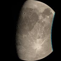
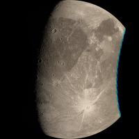
Wow! I love the first release, of the green-filter image. Ganymede is a beautiful world and these images certainly capture a representative sample of the major terrain types, from ancient plains to grooved terrain to bright crater rays. I can't wait for the results from the other instruments observing this same terrain!
Posted by: volcanopele Jun 8 2021, 06:28 PM
I for one am low-key excited about the SRU image. One of the concerns I had for the Io flybys was to what degree JunoCAM could do Jupiter-shine imaging. But from this SRU image, there is no reason I can see (except that Jupiter-shine will be stronger during the Io encounters) for the SRU not to do great Jupiter-shine imaging along with hotspot mapping.
For this SRU image itself, that that south is up in the release version, so I've attached just a flipped version:

|
For the curious, center lat and long is approximately 19N, 81W within Xibalba Sulcus. The crater at upper right is Leomadon. The bright streak at center right is possibly a distal ray from Tros (the prominent ray crater in the JunoCAM release)
And the JunoCAM image is amazing. Very crisp, very little noise... Just amazing.
Posted by: Bjorn Jonsson Jun 8 2021, 07:01 PM
We are working through some issues with our processing and I hope the images will be showing up on missionjuno shortly. In the meantime enjoy the quicklook product that NASA released.
And I want to echo the congratulations posted earlier, the green filtered image looks great. I am actually slightly (and pleasantly) surprised by how quickly this first image appeared. I have to admit though that I am probably more interested in seeing the results from the instruments (MWR etc.) that are very different from the Galileo and Voyager instruments.
Voyager 1 obtained fairly good images of some of this terrain but some of its images of e.g. Tros are smeared due to radiation (scan platform was moving when the camera shutter was open). This makes the JunoCam images more interesting.
Posted by: volcanopele Jun 8 2021, 07:25 PM
Rough idea of the timing of the SRU image. As you can see the predict kernel is a bit off, so it was actually take shortly afterward, but still gives you an idea.

|
Posted by: MarcF Jun 8 2021, 07:26 PM
Congratulations to all those involved in the JUNO mission. These first images are just amazing ! I did not expect the JunoCam pics to be so sharp and even did not know that the SRU would be able to take such Jupiter-shine images. The low Sun angle helps and we see Tros as never before. I agree with Bjorn, I'm sure that we will get many surprises once the data from the other instruments will be analyzed (internal structure, global ocean, surface composition, thin atmosphere, magnetic field,...). What a world ! The JUNO extended mission is really a new mission. This is only the beginning... and I'm already bluffed !!
Posted by: MarcF Jun 8 2021, 07:34 PM
BTW, is this a new caldera-like feature, in the Northern part of the SRU image ?
Posted by: TrappistPlanets Jun 8 2021, 07:43 PM
yeah, the sharpness is absolutely outstanding
i was even able to make a 4k map from the junocam image
https://cdn.discordapp.com/attachments/753764966863208458/851906576481910806/ganymede_juno_2021.png
if i could, i probably could make a 8k map from the image
Posted by: Brian Swift Jun 8 2021, 08:01 PM
BTW, there is a 1625x2524 TIFF version of the green-only image at https://photojournal.jpl.nasa.gov/catalog/PIA24681
Posted by: volcanopele Jun 8 2021, 08:09 PM
I'd honestly hold off. Within the next day or so I'm sure we'll have the full raw image and it can be map-projected in something like ISIS without the quick look image seams and with limb fitting/geometric control.
Posted by: TrappistPlanets Jun 8 2021, 08:16 PM
a full resolution processed image when it comes would be better than raw images, because raw images tend to have some artifacts
--edited--
Posted by: JohnVV Jun 8 2021, 08:25 PM
you will then have to wait until they are on PDS
Posted by: xflare Jun 8 2021, 09:27 PM
What a great camera !
Posted by: Brian Swift Jun 8 2021, 09:28 PM
The SRU image is nice. I had checked the geometry in Cosmographia, wondering if there would be enough Jupiter-shine to acquire a JunoCam image, but it seemed like only a crescent of Jupiter was illuminated, so I thought there wouldn't be enough light. However, seeing the SRU images make me wonder if a long-TDI JunoCam exposure would have picked up some detail.
Posted by: volcanopele Jun 8 2021, 09:46 PM
The reconstructed c-kernel is now available so let me update the Cosmographia view of the SRU frame. Somethings not quite right... makes me wonder if the FOV for the SRU in the instrument kernel (juno_struct_v02.ti) is correct. It lists it as having a FOV of 16°x16°.
EDIT: found the paper describing the SRUs. Yep, intstrument kernel is wrong according to Becker et al. 2017. Given what I'm seeing, I trust the paper. Will update the figure in a few minutes.
EDIT2: Updated SRU preview graphic with updated FOV. Still looks like the real image is a bit to the east of where this shows...

|
Pixel scale comes out to 618 m/pixel.
Posted by: vjkane Jun 8 2021, 09:50 PM
I am impressed with the images.
There's a proposed mission concept for a Juno-like orbiter at Uranus (QUEST). The focus is the planet's interior and magnetosphere (like Juno before this extended mission). The proposers pointed out their JunoCam-like camera could also image the moons during flybys, and I mentally poo-pooed it. Now, I'm thinking that it would do better geologic science than I thought. And if a Juno-like mission had a goal for satellite imaging, it could carry a medium-resolution camera.
Posted by: Brian Swift Jun 8 2021, 10:27 PM
Can you give me title or link. I don't think I have that in my collection.
Posted by: Bjorn Jonsson Jun 8 2021, 10:27 PM
I didn't expect this to happen until the arrival of JUICE in 2029 but some of the current images/maps of Ganymede seem to have become very obviously outdated today.
Here is a very quick-and-dirty montage comparing what I think is the best pre-Juno image of Tros to the new image - the improvement is obvious:

|
The image at left is a lightly processed version of Voyager 1 image C1640422 at its original size. As far as I know this is the best image of Tros before Juno. There is a later image at theoretically higher resolution but it is badly smeared. There are also some images with Tros closer to the limb; there the emission angle is too high.
Galileo obtained only low resolution images of Tros.
Posted by: JRehling Jun 8 2021, 10:28 PM
Using the green-frame image and doing a little old-fashioned measurement, it is stretched about 8.2% in the downtick direction and can be circularized by multiplying that dimension by 0.92. I believe that what others derive by other means should inevitably agree with that.
Posted by: volcanopele Jun 8 2021, 10:44 PM
The Juno Radiation Monitoring (RM) Investigation
Becker et al.
Space Sci Rev (2017) 213:507545
https://doi.org/10.1007/s11214-017-0345-9
Posted by: TrappistPlanets Jun 8 2021, 11:08 PM
okay, i'll hold of on an 8k map
Posted by: TrappistPlanets Jun 8 2021, 11:10 PM
Here is a very quick-and-dirty montage comparing what I think is the best pre-Juno image of Tros to the new image - the improvement is obvious:
|
|
The image at left is a lightly processed version of Voyager 1 image C1640422 at its original size. As far as I know this is the best image of Tros before Juno. There is a later image at theoretically higher resolution but it is badly smeared. There are also some images with Tros closer to the limb; there the emission angle is too high.
Galileo obtained only low resolution images of Tros.
Bjorn, Juno did an outstanding job of getting the full details of Tros and other blurry areas that Juno got sharp images of
"I didn't expect this to happen until the arrival of JUICE in 2029 but some of the current images/maps of Ganymede seem to have become very obviously outdated today."
yup, a large part of what Juno imaged was a bit blurred in already existing maps
Posted by: Brian Swift Jun 8 2021, 11:31 PM
Becker et al.
Space Sci Rev (2017) 213:507545
https://doi.org/10.1007/s11214-017-0345-9
Thanks. Grumble paywall grumble.
Just a bit of the downside of being an unaffiliated unfunded community scientist.
At least the Mars papers I've looked for have been open-access.
Posted by: mcaplinger Jun 9 2021, 12:25 AM
Ganymede images now on missionjuno.
Posted by: Brian Swift Jun 9 2021, 12:48 AM
Posted by: JRehling Jun 9 2021, 12:53 AM
Wow! The Ganymede image processing already looks great on missionjuno. The brightest areas are running closer to coffee-colored than the whites that I've seen from, e.g, Voyager and Galileo. It's one of the most beautiful worlds in the solar system, if I may use technical terminology.
Posted by: volcanopele Jun 9 2021, 01:09 AM
Very rough cut:

|
Looks like I need to make a control point network... hooray!
Posted by: Ian R Jun 9 2021, 01:15 AM
My humble offering of a re-projected red-filtered frame:
https://www.flickr.com/photos/10795027@N08/51235091798
Posted by: antipode Jun 9 2021, 01:19 AM
Wow! Just spectacular. I wasn't aware how many large craters on Ganymede have central pits instead of peaks or peak rings.
Presumably something to do with the gravity/surface composition/relaxation time?
People are going to be pouring over these for weeks.
And that SRU image is a wonder, as others have pointed out, very interesting for future gas and ice giant missions (OT I know)
P
Posted by: Bjorn Jonsson Jun 9 2021, 01:36 AM
Here is a very quick & preliminary version of image pj34_01 at roughly the original resolution showing Ganymede with the crater Tros prominent below and right of center:

|
Here Juno's altitude above Ganymede's surface was ~1300 km. The image may have some minor geometric inaccuracies that will be corrected if necessary in a later version.
Posted by: Brian Swift Jun 9 2021, 01:56 AM
My first cut. Collage of first four Ganymede images. Un-exaggerated color/contrast.
Click through for full-res version.
https://flic.kr/p/2m4smohhttps://flic.kr/p/2m4smoh by https://www.flickr.com/photos/bswift/, on Flickr
Also, 297 MB 16-bit PNG version now available at https://www.missionjuno.swri.edu/junocam/processing?id=10668
Posted by: Ian R Jun 9 2021, 02:27 AM
A semi-manual attempt at a color composite:
https://flic.kr/p/2m4p55Hhttps://flic.kr/p/2m4p55H by https://www.flickr.com/photos/10795027@N08/, on Flickr
Posted by: JRehling Jun 9 2021, 02:48 AM
Presumably something to do with the gravity/surface composition/relaxation time?
Impactors hitting Ganymede gain velocity from falling into Jupiter's gravitational field. Because we see little to none of that with Io and Europa, Ganymede is the primary location where we see the results of that.
Posted by: Michael Capobianco Jun 9 2021, 03:22 AM
I usually just lurk here, but these image are so spectacular and so much better than I was expecting, I had to say something. Reminds me of when I first saw Ganymede in 1979. Thanks, Juno!
Posted by: stevesliva Jun 9 2021, 03:30 AM
If this is the 2nd most-boring Galilean, I can't wait to see the less-boring ones.
Posted by: Gladstoner Jun 9 2021, 04:31 AM
I almost mistook the wide-field Ganymede image for Earth's moon in a media report on my phone, with its 'Tycho', 'Crisium' and 'Imbrium'.
Posted by: JRehling Jun 9 2021, 05:05 AM
I have a hard time formalizing what it is about this encounter but it is one of the best and purest example of a "free" flyby that wasn't in a mission's original plan that I can think of. There have been some great flybys of opportunity (like Venus on Galileo's way to Jupiter) and certainly Galileo and Cassini both had endless satellite encounters that weren't specifically planned but were very much like what one expected for an extended mission. This is more like a holiday gift than anything else I can recall, with Gaspra, various Phobos/Deimos encounters and Arrokoth some similar occasions.
Posted by: Phil Stooke Jun 9 2021, 06:25 AM
antipode: "Wow! Just spectacular. I wasn't aware how many large craters on Ganymede have central pits instead of peaks or peak rings."
After Voyager 1 observed these pit craters in 1979 people pointed out very similar craters on Mars - far from every crater obviously but in some areas there are quite a lot. The inference at the time was that they were related to impacts in an icy crust. I don't know how well that idea has survived subsequent analysis.
Phil
Posted by: Gerald Jun 9 2021, 06:51 AM
Obviously, I'm a little slow.
http://junocam.pictures/gerald/uploads/20210609a/index.html.
Posted by: TrappistPlanets Jun 9 2021, 10:50 AM
Click through for full-res version.
https://flic.kr/p/2m4smohhttps://flic.kr/p/2m4smoh by https://www.flickr.com/photos/bswift/, on Flickr
Also, 297 MB 16-bit PNG version now available at https://www.missionjuno.swri.edu/junocam/processing?id=10668
OMG those are downright beautiful!!
Posted by: Decepticon Jun 9 2021, 02:04 PM
If Ganymede is this beautiful, Europa & Io are going to be wonderful.
I do hope the Distant look at Europa happens this July.
Posted by: volcanopele Jun 9 2021, 04:31 PM
Thanks Ganymede for finally convincing me to send in an ISIS bug report...
https://astrodiscuss.usgs.gov/t/uncaught-exemption-in-jigsaw-when-solving-for-s-c-position/702
Posted by: Kevin Gill Jun 9 2021, 05:15 PM
Ganymede composites of PJ34-1 & PJ34-2:
https://flic.kr/p/2m4DjoB
https://flic.kr/p/2m4DjoB
https://flic.kr/p/2m4EMLr
https://flic.kr/p/2m4EMLr
Posted by: sabare Jun 9 2021, 05:48 PM
This is my first post here after lurking since 2015 
I just wanted to say that the images from this flyby are absolutely stunning!
Posted by: MarcF Jun 9 2021, 06:09 PM
Just one naive question: is the resolution high enough to make some DEMs ? I think it should be possible between the first two images... or even between JUNO and Voyager 1 images from the same region.
Posted by: Toma B Jun 9 2021, 06:16 PM
Thank you very much!!! Been waiting for this for a long time. I know I'm not the only one.
Posted by: JRehling Jun 9 2021, 06:27 PM
Kevin Wow! Thanks for that. I just shivered.
Regarding DEMs, I don't think that the resolution here can add much to global topographical maps, but the altitudes of features casting shadows can be measured, and that includes a useful diversity of major feature types grooves and craters.
Posted by: jasedm Jun 9 2021, 06:53 PM
Nothing short of astonishing - I'm gobsmacked by the resolution and clarity
Posted by: Floyd Jun 9 2021, 07:07 PM
Kevin and all on the Juno team--Thank you--I agree with jasedm--this is astonishing resolution and clarity
Posted by: Brian Swift Jun 9 2021, 07:08 PM
BTW, a new SCLKSET file was posted this morning. Don't know yet how big an impact it will be on positions, but I'm rerunning my processing now.
Posted by: Brian Swift Jun 9 2021, 10:35 PM
Either Ganymede has shrunk or JunoCam is taking pics from a position further away than the SPICE location.
Dots are along SPICE limb, and are symmetric between leading and trailing limb.

|
Now I wonder if we'll get a refined spk_pre (positions predicted kernel) before the post apogee reconstructed kernel delivery.
Posted by: volcanopele Jun 9 2021, 10:37 PM
That's what I'm seeing in ISIS. I have a control network that should be able to fix the issue, but I ran into the issue with jigsaw and its ability to adjust s/c position I mentioned above.
EDIT: Since jigsaw can at least run without updating pointing, it seems to think that the spacecraft position is off by 23 km...
Posted by: Bjorn Jonsson Jun 9 2021, 10:46 PM
...
Now I wonder if we'll get a refined spk_pre (positions predicted kernel) before the post apogee reconstructed kernel delivery.
I'm also seeing errors that complicate the processing. Usually the difference between the predict and reconstructed SPKs isn't big but this time I'm expecting a significant difference. I was going to do a map-projected mosaic of all of the images but I might delay it until a few weeks from now when a reconstructed SPK becomes available.
Posted by: Saturns Moon Titan Jun 9 2021, 11:50 PM
Not much to add here other than just to echo that these Ganymede images are just phenomenal, far above my expectations. I'm certain just these few images alone will be the basis of new papers. Thanks so much to the JunoCam team and the people here processing these images. The 320 km Europa flyby on September 29th 2022 is going to blow our minds 
Posted by: TrappistPlanets Jun 10 2021, 12:49 AM
yeah, the sharpness of those images was way better than what i was expecting
and i agree, if we can get this sharp of images from Ganymede, than imagine what we could get from Europa
anyways, here is a updated map that has more coverage derived from the images from 2 days ago
(ik some areas in the thing is a bit blurry, i was trying to fix a bad joint from where the lighting didn't line up in the 2 images that was involved to make this map...)
Posted by: Bill Harris Jun 10 2021, 02:49 AM
Ganymede... much like Snowball Earth 1 or 2 Billion years ago. A global ocean with an ice shell underlain by a warm silicate planetary body.
Posted by: owlsyme Jun 10 2021, 08:38 AM
https://flic.kr/p/2m4EMLr
Thank you, Kevin - that's perfect!
And thank you to the Juno team, and all who got the extended mission going. I didn't know about it, but there will be other close flybys. Only wish there could be more!
Europa 29-SEP-2022
Io 30-DEC-2023
Io 03-FEB-2024
The wait begins...
Posted by: MarcF Jun 10 2021, 10:35 AM
The northern polar cap and magnetic field lines boundary crosses these pictures, north of Perrine Regio. The illumination does not allow JunoCAM to see it. I am sure that JIRAM on its side could distinguish it very well. Moreover, I wonder if the aurora could be detected on the night side. This encounter will probably give us many more surprises. So exciting !
Posted by: TrappistPlanets Jun 10 2021, 11:00 AM
is it possible to pull night shine from these images that could fill unmapped areas on existing maps?
Posted by: Kevin Gill Jun 10 2021, 06:48 PM
Another Ganymede composite. Better color, though not perfect. Uses the first three images (PJ34-1,2,3) and uses the perspective of the third.
https://flic.kr/p/2m4MwqW
https://flic.kr/p/2m4MwqW
Posted by: MarcF Jun 10 2021, 07:22 PM
Wow, these composites get better and better. Thanks a lot to all the talented people making them. It is always a pleasure to see a new one :-)
Just realize that part of this region has be photographed by Galileo (orbit G29) at about the same resolution:
https://rpif.asu.edu/Galileo/G29/fullsize/G29GSCAPCOL01.png
Nice exercise to compare and search for some changes (new impacts) after 20 years :-)
Posted by: HSchirmer Jun 10 2021, 09:28 PM
Or new furrows? Rather like comparing post-earthquake LIDAR scans to see what sort of displacement you get.
Posted by: antipode Jun 10 2021, 09:47 PM
When might we expect some magnetometer and UV spectrograph data from the pass?
Is there any chance we might see some of Ganymede's UV auroras?
P
Posted by: Marcin600 Jun 10 2021, 10:23 PM
An interesting fragment of Ganymede's surface. A bit similar to Enceladus.

|

|

|

|
Posted by: volcanopele Jun 10 2021, 11:10 PM

|
Going to throw my hat in the ring with my version. Not perfect yet, and probably won't be until this bug in ISIS gets fixed (or when a reconstructed trajectory kernel is released), so there there is some color fringing. Can't wait to try to do some color ratioing. There aren't a lot of apparent color variations, but you never know.
Posted by: TrappistPlanets Jun 11 2021, 12:11 AM
i think i can color my map with the natural colors of ganymede
Posted by: TrappistPlanets Jun 11 2021, 12:52 AM
not exactly natural color but this was my attempt from color processing my Ganymede grey-scale map to give it color
Posted by: TrappistPlanets Jun 11 2021, 01:20 AM
i did some processing to this grey-scale image ( https://www.missionjuno.swri.edu/junocam/processing?featured=1 ) and created a false colored image (it was a lot of channel mixing, node blending, level and curves editing, and a lot of saturation editing
here is my result
(this is a preview below, the full resolution image was dam too big for UMSF to attach)

|
Posted by: Julius Jun 11 2021, 06:53 PM
Close up views of the surface showing the ridges remind of a similar process happening on Europa.
Posted by: TrappistPlanets Jun 11 2021, 11:24 PM
Just realize that part of this region has be photographed by Galileo (orbit G29) at about the same resolution:
https://rpif.asu.edu/Galileo/G29/fullsize/G29GSCAPCOL01.png
Nice exercise to compare and search for some changes (new impacts) after 20 years :-)
if juno was able to image that spot in high detail, than how come it was unable to get that good of an image of Tros as juno did a couple days ago?
and i think that could be processed into a dem
Posted by: volcanopele Jun 11 2021, 11:28 PM
Because Galileo had the data volume of a gnat. Given the constraint of playing everything back through the low-gain antenna, mission ops had to be very selective of what images to take and what to play back. Based on the observation name, I presume they were interested in the margin of the polar frost cap.
Posted by: Kevin Gill Jun 12 2021, 12:03 AM
Moving on to Jupiter, I'm getting really bad color results out of my pipeline. Anyone else seeing this or is it just me?

|
Posted by: volcanopele Jun 12 2021, 12:14 AM
A bit more uncertainty in the predict trajectory?
Posted by: Bjorn Jonsson Jun 12 2021, 12:43 AM
The color I get looks normal but the contrast in your image seems lower than it should be. Is it possible that you are not decompanding the images?
And BTW the contrast in some of the Ganymede images (in most cases not your images) I've seen here also seems somewhat lower than what I'm getting. Therefore I'm wondering if some of the Ganymede images here are maybe not decompanded but I haven't taken a detailed look yet so I might be wrong.
Posted by: TrappistPlanets Jun 12 2021, 11:29 AM
And BTW the contrast in some of the Ganymede images (in most cases not your images) I've seen here also seems somewhat lower than what I'm getting. Therefore I'm wondering if some of the Ganymede images here are maybe not decompanded but I haven't taken a detailed look yet so I might be wrong.
yeah, the contrast of some of the color processed images have very high contrast, and others have lower contrast (a bit more realistic)
i ended up getting a high contrast in my attempt
(altho this was intentional because i wanted to make a high contrast false colored image)

|
Posted by: TrappistPlanets Jun 12 2021, 11:30 AM
|
|
looks pretty realistic to me in terms of color and gamma, all though there could be a bit more contrast...
Posted by: Kevin Gill Jun 12 2021, 10:04 PM
And BTW the contrast in some of the Ganymede images (in most cases not your images) I've seen here also seems somewhat lower than what I'm getting. Therefore I'm wondering if some of the Ganymede images here are maybe not decompanded but I haven't taken a detailed look yet so I might be wrong.
You called it! I had replaced the decompanding method for one that I use on other projected that a lot more performant. Not sure why it didn't work in this instance. Restoring the previous method worked.

|

|
Posted by: TrappistPlanets Jun 13 2021, 12:08 AM
|
|
|
|
now that jupiter map looks perfact
contrast of the ganymede map looks good, but the color is a bit off if your going for a natural color, and btw what reprojection program did you use to reproject juno's highly distorted ganymede images?
Posted by: Bjorn Jonsson Jun 13 2021, 08:51 PM
This is an approximately true color/contrast mosaic of images pj34_01 and pj34_02 seen from the pj34_02 viewpoint:

|
The color is based mainly on color computed from Ganymede's global visible light spectrum. It is a bit approximate and subjective though. The color of the two images (pj34_01 and pj34_02) wasn't perfectly identical. Probable reasons are imperfect bias removal, imperfect flat fielding, scattered light, different exposure or some combination of these factors. In theory it might now be easier to improve the flat fields and/or bias. Ganymede doesn't have an atmosphere which means that variations in emission angle are probably much less significant than in the Jupiter (and Earth) images. Ganymede also provides a nice sanity check since it is the first airless imaging target imaged by JunoCam at high resolution. This makes accurate limb fits trivial (no clouds/hazes at the limb to mess things up). I used this to make some checks and tests that are more difficult to do when processing JunoCam images of Jupiter (or the Earth). Everything worked as expected.
As discussed in earlier posts, it is clear that Juno passed slightly farther from Ganymede than intended (this is normal). The absolute error doesn't seem bigger than for a typical Jupiter flyby. The difference is that it is much larger relative to Ganymede (which is much smaller than Jupiter) and must be corrected if high quality results are desired. To fix this it turned out to be easier for me to simply shrink Ganymede slightly in my processing pipeline instead of adjusting the position of the spacecraft.
EDIT: Added different exposure as one possible reason for the slight color difference.
Posted by: HSchirmer Jun 13 2021, 09:10 PM
I look forward to somebody modeling upwelling, downwelling, and 'deccan traps' style hotspot flooding & resurfacing based on odd or even numbers of convection cells.

|
Posted by: volcanopele Jun 13 2021, 09:17 PM
Thanks to Bjorn for hinting how to fix the color issues. Here is my latest attempt at the first mosaic:

|
Still am unhappy with the limb fit and the color fringing. But I think for now this is the best that ISIS can do until some fixes come for libale (why is alway libale...)
Posted by: mcaplinger Jun 13 2021, 10:00 PM
Thanks for diving so deeply into the ISIS problems, Jason. Anything that improves ISIS behavior for Junocam benefits not only these flybys, but Junocam processing in general.
Note that we could have the typical level of error in the first frame's start time value for each of these images, though I expect at the moment those are swamped by the error in the SPK.
Posted by: Brian Swift Jun 14 2021, 01:24 AM
Anyone know if Juno reconstructed SPICE accuracy information is available anywhere?
I didn't find a way of accessing it via SPICE API with a quick search of the docs.
Like Björn, I hope to do some validation and refinement of my model using Ganymede imagery,
and think knowledge of the SPICE position/orientation/timing accuracy will be useful for that.
Posted by: Kevin Gill Jun 14 2021, 01:25 AM
contrast of the ganymede map looks good, but the color is a bit off if your going for a natural color, and btw what reprojection program did you use to reproject juno's highly distorted ganymede images?
I'm using ISIS (junocam2isis, cam2map, map2map, isis2std), and Blender: https://github.com/kmgill/cassini_processing/blob/master/sciimg/pipelines/junocam/processing.py
Posted by: JohnVV Jun 14 2021, 01:51 AM
I didn't find a way of accessing it via SPICE API with a quick search of the docs.
Like Björn, I hope to do some validation and refinement of my model using Ganymede imagery,
and think knowledge of the SPICE position/orientation/timing accuracy will be useful for that.
this is where they are
ftp://naif.jpl.nasa.gov/pub/naif/JUNO/kernels/spk/
the last reconstructed is from 5/17/21
and
ftp://naif.jpl.nasa.gov/pub/naif/JUNO/kernels/ck/
the last rotational kernel is from 6/8/21
Posted by: Brian Swift Jun 14 2021, 05:29 AM
Local Youth Does Good... https://apod.nasa.gov/apod/ap210614.html
Posted by: PDP8E Jun 14 2021, 03:40 PM
Nice work Kevin!
Posted by: NMRguy Jun 21 2021, 02:40 AM
Great work, guys! This is still the place I come for the best imagery hot off the presses. Very impressive.
When I initially heard about the planetary physics science that Juno proposed to study, I was really happy, but I feared that there might be a missed opportunity with the public. Enter JunoCam and all of those fears were demolished. It's a great little camera that has far exceeded its life expectancy!
I'm also amazed that the orbital planning wizards figured out how to accomplished the Galilean Moon flybys in the 53 day orbit. Just great work seizing these opportunities and we are all better for this exploration.
One question for the group--does anyone know how much coverage the Juno Stellar Reference Unit navigation camera collected on the dark side of Ganymede? The initial public release cited a very respectable resolution on the SRU imagery, but I don't have a great feel if that was just because the closest approach was on the dark side of the moon or if it's just a high pixel density camera to precisely determine the satellite's position in space during normal operations. Best I can tell, it is a framing camera (vice JunoCam's pushbroom), so it must be programmed to acquire images at some regular (or in the case of the Ganymede flyby, more frequent?) rate. Any knowledge welcome! Thanks.
Posted by: Antdoghalo Jun 24 2021, 04:57 AM
I'd like to know too. Such a tool would be SUPER useful for a Uranus and Neptune mission. The mapping potential is out there! Maybe cover some of those elusive polar areas of the Jovian moons. It's always interesting when you find another possible unintended use for an instrument.
Posted by: Brian Swift Jun 24 2021, 10:58 PM
Hi NMRguy, I replied with the SRU information I have here: http://www.unmannedspaceflight.com/index.php?showtopic=8553&view=findpost&p=253254
Posted by: volcanopele Jun 29 2021, 08:23 PM

|
Taking another pass at 34C00001. Again, only the pointing was updated, not the spacecraft position due to a bug in ISIS 5.0.0. This used a larger control point network (a little over 2000 hand-adjusted points) that combined images from 34C00001 and 34C00002 and reduced the number of fixed points (fixed to a Voyager/Galileo-era basemap. Slight adjustments have been made in Photoshop to the width of each channel in the final mosaic to reduce color fringing. I think with this product I am calling it until either the reconstructed trajectory is available, or the jigsaw bug is fixed. I might try my hand at making a combined product of the two mosaics, but I haven't gotten around to that yet.
Posted by: Bjorn Jonsson Jul 15 2021, 01:23 AM
I noticed that a reconstructed SPK is now available. Not unexpectedly, the flyby distance is slightly larger in the reconstructed SPK than in the predict SPK. For the first Ganymede image (pj34_1) the difference is ~6.4 km at START_TIME.
Posted by: volcanopele Jul 15 2021, 05:07 PM
It did reduce the offsets I've been seeing, but not eliminate them. Here's hoping ISIS 5.1 will be out soon.
Posted by: Bjorn Jonsson Jul 17 2021, 09:17 PM
Same result here. From my preliminary results Juno is still too close to Ganymede in the new SPK kernel. The error is much smaller now though but I still haven't determined how big it is.
Posted by: Brian Swift Jul 17 2021, 10:32 PM
Are you referring to the maps at
https://astrogeology.usgs.gov/search/map/Ganymede/Voyager-Galileo/Ganymede_Voyager_GalileoSSI_Global_ClrMosaic_1435m. (color)
and
https://astrogeology.usgs.gov/search/map/Ganymede/Voyager-Galileo/Ganymede_Voyager_GalileoSSI_global_mosaic_1km (greyscale)
or is there another map somewhere?
I looked at the above two, and noticed that the patchwork of images does not line up between them. Also, the IAU nomenclature (from http://planetarynames.wr.usgs.gov/shapefiles/GANYMEDE_nomenclature.zip) aligns with greyscale version.
The descriptions on those pages are basically identical, not giving an explanation for the misalignments.
Posted by: Phil Stooke Jul 18 2021, 04:44 AM
Every time you run a mosaic sequence like that you will get slight variations in how things line up depending on the exact numbers used for camera pointing and position. It's not easy to say which is going to be more accurate. To get beyond that you need a better geodetic solution from, for example, an orbital laser altimeter. We are not there yet for Ganymede.
Phil
Posted by: MarcF Jul 18 2021, 10:54 AM
BTW, some relaxation with so much beauty:
https://www.youtube.com/watch?v=CC7OJ7gFLvE
Have a great Sunday.
Regards,
Marc.
Posted by: volcanopele Jul 19 2021, 05:40 PM
Just using the pointing as a guide, slower encounter than last time so there should be plenty of opportunities for JunoCAM to image Ganymede, though at a much lower resolution (31 km/px). http://pirlwww.lpl.arizona.edu/~perry/Juno/Screen%20Shot%202021-07-19%20at%2010.35.33%20AM.png
Posted by: volcanopele Jul 22 2021, 07:38 PM
If you are me and are suspecting that some remaining issues are due to the USGS global mosaic being... less than perfect when it comes to using it for geometric control, there is a new controlled global mosaic produced for the JUICE mission:
https://www.sciencedirect.com/science/article/pii/S0032063321001495 (article is open-access)
It maybe a few weeks before I get a chance to try it, but... not a bad thing to test instead of the USGS global mosaic.
(small note: why oh why would the JUICE team use planetocentric East longitudes. insert panda smashing keyboard gif here)
Posted by: john_s Jul 22 2021, 10:01 PM
Alas for us old-timers who have used West longitudes forever, East longitudes are going to be the new standard for the Galilean satellites. I think JUICE started the trend, but Europa Clipper is adopting the same standard for consistency, amid much grumbling from the old guard.
John
Posted by: Bjorn Jonsson Jul 22 2021, 11:48 PM
https://www.sciencedirect.com/science/article/pii/S0032063321001495 (article is open-access)
It maybe a few weeks before I get a chance to try it, but... not a bad thing to test instead of the USGS global mosaic.
(small note: why oh why would the JUICE team use planetocentric East longitudes. insert panda smashing keyboard gif here)
Thanks for pointing this out, this was the perfect time for a Ganymede map with better geometric control. Measuring a few points in Juno image PJ34_1 and the corresponding points in the new map I get a distance from Ganymede that is ~5 km larger than the distance value from the reconstructed SPK. This is almost identical to the distance value I get by decreasing Ganymede's radius until the limb fits for image PJ34_1 match an interframe delay value of 0.372 (shrinking Ganymede is easier in my processing pipeline than increasing the target center distance).
Using the USGS map resulted in the same distance as from the reconstructed SPK (or possibly 1-2 km larger distance). To me this result was surprisingly different from the limb fit result but inaccuracies in the USGS map are probably to blame.
The above results are preliminary though and I need to double check them.
Adopting a new longitude system must be highly confusing.
Posted by: mcaplinger Jul 23 2021, 12:31 AM
We lost this battle for Mars back in 2001. https://www.msss.com/mgcwg/mgm/letter.txt
Posted by: volcanopele Jul 23 2021, 03:21 PM
I blame the spectroscopists.
Seriously, it doesn't matter THAT much, as long as... oh I don't know, your image search tool sticks with ONE of them and doesn't use East on the search page and West on the results page and east in the individual image page... (not directed at you Mike, but at another Mars instrument...)
It matters for Io... my mental map is based in west longitude...
Posted by: JRehling Jul 23 2021, 03:44 PM
This is giving me choleric nostalgia for south-is-up maps of the Moon and Mars in astronomy books because observers with their sketchpad and eyepiece were too set-in-their ways to take one second to rotate their sketchpad 180° when they were done sketching.
Posted by: stevesliva Jul 23 2021, 04:11 PM
Alternatively, they could move the telescope to Australia. That would be the XKCD way.
Posted by: volcanopele Jul 23 2021, 06:19 PM
Moved the discussion about the PJ35 flyby to its own topic:
http://www.unmannedspaceflight.com/index.php?showtopic=8643
Posted by: volcanopele Jul 26 2021, 06:41 PM
https://www.sciencedirect.com/science/article/pii/S0032063321001495 (article is open-access)
The mosaics are available at https://janus.dlr.de/publications/ganymede/Ganymede_Mosaic.html
to get the first mosaic into ISIS I used the following commands:
to=Ganymede_global_equi_000_359m.cub mode=grayscale
maptemplate map=projection_dlr.map projection=EQUIRECTANGULAR clat=0.0 clon=0.0 \
londir=POSITIVEWEST londom=360 eqradius=2631200 polradius=2631200 \
lattype=Planetocentric Targetname=Ganymede targopt=user rngopt=user \
minlat=-90.0 maxlat=90.0 minlon=0.0 maxlon=360.0 resopt=mpp \
resolution=358.774244364249967
maplab from=Ganymede_global_equi_000_359m.cub map=projection_dlr.map \
sample=23040.5 line=11520.5 x=0.0 y=0.0
I would just post the cub file but it came out to be 4.25 GB
Posted by: Brian Swift Jul 30 2021, 01:01 AM
Ive posted preliminary PJ34 Ganymede equirectangular maps at missionjuno.
PJ34_01 https://www.missionjuno.swri.edu/junocam/processing?id=11142
PJ34_02 https://www.missionjuno.swri.edu/junocam/processing?id=11141
PJ34_03 https://www.missionjuno.swri.edu/junocam/processing?id=11140
PJ34_04 https://www.missionjuno.swri.edu/junocam/processing?id=11139
PJ34_05 https://www.missionjuno.swri.edu/junocam/processing?id=11138
Maps are 32 pixel/degree. The spacecraft position and image timing solution used a 420 control-point network and a limb fit with 120 to 220 points.
The control network is strictly self-referential. No attempt was made to tie features to other maps or IAU nomenclature points.
No attempt was made to mitigate illumination/view angle dependent brightness changes or camera internal reflections, other than application of a scale factor to produce roughly similar brightness between images. The contrast is intended to be natural-ish.
Below is a transfer format SPK file covering just the period of the Ganymede encounter images for anyone who wants to try this solution with ISIS. It can be converted to a binary SPK with the SPICE tobin utility.
This Juno SPK just implements a fixed offset to the default reconstructed SPK by adding {-2.625, 19.375, 2.125} to the Juno XYZ position in its native ephemeris configuration (Reference frame=J2000, Observing body=JUPITER BARYCENTER).
The start time additive offsets in seconds are:
"P34_01" -> -0.0399998, "P34_02" -> 0.00188565, "P34_03" -> 0.00839715, "P34_04" -> 0.00361281, "P34_05" -> 0.
Caveat: Solution derived using my camera model, so a constant shift may need to be applied to the timing offsets.
PJ34_05 didn't participate in the solution but is included just for completeness.
cat pj34bsspktbl.xsp
'DAF/SPK '
'2'
'6'
'SPK '
BEGIN_ARRAY 1 70
'pj34bsspktbl.csv '
'2850637E^8'
'285065B8^8'
'-3D'
'5'
'1'
'8'
70
'1DDD8878FAEB96^5'
'-E9D2BA4353183^5'
'-6F539DF67390F4^5'
'-27670A7FAC37DE^1'
'A929B182A93A88^1'
'97B1438A61696^1'
'1DD4B3D51EB7A^5'
'-E9AD12CDA8EEE^5'
'-6F31E0913EE95C^5'
'-27E716FF58BEEC^1'
'A90B883384996^1'
'975AAA50702CB8^1'
'1DCBC662B63C4F^5'
'-E98774BC4A938^5'
'-6F1038F0DFAA84^5'
'-2842194DDEB866^1'
'A8D8241BB85F2^1'
'96F229CF0B4E1^1'
'1DC2C9C7DE8125^5'
'-E961E2ABC2A778^5'
'-6EEEA80F53D18C^5'
'-287052C9FE8C9E^1'
'A8A2DF087B7CF8^1'
'9692117F0AD2E8^1'
'1DB9C6AF953F1B^5'
'-E93C5B551FBC^5'
'-6ECD2A3A0DA61^5'
'-287F4845AA4D1E^1'
'A87906E9352E38^1'
'9647EBB7CFF618^1'
'1DB0C2415940AA^5'
'-E916DBB55D29C8^5'
'-6EABBA66E49724^5'
'-287E6D91631E42^1'
'A85D7666A89618^1'
'961397D23E14A^1'
'1DA7BED7E6B912^5'
'-E8F160CFB6A4A^5'
'-6E8A5440AD0AC8^5'
'-28773897123834^1'
'A84E10A23458E8^1'
'95F0213B2BC75^1'
'1D9EBD4A482941^5'
'-E8CBE84436308^5'
'-6E68F495DB4374^5'
'-286E382A11683^1'
'A847DAAA2E081^1'
'95D8A9C93C4698^1'
'1D95BDBF44C7B7^5'
'-E8A670514EC4A^5'
'-6E47992776CEB4^5'
'-28655D084814F^1'
'A84857F37F8688^1'
'95C994E15A8F4^1'
'1D8CC0160F5546^5'
'-E880F7AFECBBE^5'
'-6E264062718444^5'
'-285D624E2EA57^1'
'A84DB752C580A8^1'
'95C0698E6C6E8^1'
'1D83C41532EA5B^5'
'-E85B7D70873D18^5'
'-6E04E92838892^5'
'-28567CCD933D54^1'
'A856B1571DB91^1'
'95BB7DD96EE0F8^1'
'2850637E^8'
'39^2'
'5^1'
'B^1'
END_ARRAY 1 70
TOTAL_ARRAYS 1
~NAIF/SPC BEGIN COMMENTS~
********************************************************************************
Juno PJ34 Ganymede Photogrametric reconstruction, preliminary
********************************************************************************
MKSPK RUN DATE/TIME: 2021-07-28T21:13:42
MKSPK SETUP FILE: pj34bsspktbl.setup
MKSPK INPUT FILE: pj34bsspktbl.csv
MKSPK OUTPUT FILE: pj34bsspktbl.bsp
OUTPUT FILE STATUS: NEW FILE
********************************************************************************
\begindata
INPUT_DATA_TYPE = 'STATES'
OUTPUT_SPK_TYPE = 8
OBJECT_ID = -61
CENTER_ID = 5
REF_FRAME_NAME = 'J2000'
PRODUCER_ID = 'Brian Swift'
DATA_ORDER = 'epoch x y z vx vy vz '
DATA_DELIMITER = ','
LINES_PER_RECORD = 1
LEAPSECONDS_FILE='/Users/bswift/Downloads/junospice/kernels/lsk/naif0012.tls'
INPUT_DATA_FILE = 'pj34bsspktbl.csv'
OUTPUT_SPK_FILE = 'pj34bsspktbl.bsp'
COMMENT_FILE = 'pj34bsspktbl.comment'
IGNORE_FIRST_LINE = 0
LINES_PER_RECORD = 1
TIME_WRAPPER = '# ETSECONDS'
POLYNOM_DEGREE = 5
APPEND_TO_OUTPUT = 'NO'
\begintext
********************************************************************************
~NAIF/SPC END COMMENTS~
FWIW, 98% of control network residuals < 3.6km, 89%<2km.

|
Posted by: volcanopele Jul 30 2021, 05:38 PM
getting the following error with tobin:
Converting: pj34bsspktbl.xsp
To: pj34bsspktbl.bsp
================================================================================
Toolkit version: N0066
SPICE(FILEREADFAILED)
Error reading the text file: pj34bsspktbl.xsp. IOSTAT = -1.
A traceback follows. The name of the highest level module is first.
TOBIN --> ZZCONVTB
================================================================================
Not sure what it hates about the text file. It can definitely see it. A quick change to CR-LF line endings gave me a different error.
Posted by: Brian Swift Jul 30 2021, 07:38 PM
Not sure what it hates about the text file. It can definitely see it. A quick change to CR-LF line endings gave me a different error.
I just copied the text from the post above and pasted into a file test1.xsp.
It gave me the same file that I produced, and "tobin" worked on it.
The bsp file produced from "tobin" matches my initial bsp.
You can check your files against the below md5 checksum.
bswift@HiCat j6 % /Users/bswift/Downloads/cspice/exe/tobin test1.xsp
Converting: test1.xsp
To: test1.bsp
bswift@HiCat j6 % ls -l pj34bsspktbl.xsp test1.xsp
-rw-r----- 1 bswift staff 2827 Jul 28 22:01 pj34bsspktbl.xsp
-rw-r----- 1 bswift staff 2827 Jul 30 12:23 test1.xsp
bswift@HiCat j6 % md5 pj34bsspktbl.xsp test1.xsp
MD5 (pj34bsspktbl.xsp) = 6d37da4d86ae344ac8a5d54c997dbb7e
MD5 (test1.xsp) = 6d37da4d86ae344ac8a5d54c997dbb7e
bswift@HiCat j6 % ls -l pj34bsspktbl.bsp test1.bsp
-rw-r----- 1 bswift staff 6144 Jul 28 22:04 pj34bsspktbl.bsp
-rw-r----- 1 bswift staff 6144 Jul 30 12:24 test1.bsp
bswift@HiCat j6 % md5 pj34bsspktbl.bsp test1.bsp
MD5 (pj34bsspktbl.bsp) = 51f7fb8ac06c4a84ef468b1f7335b909
MD5 (test1.bsp) = 51f7fb8ac06c4a84ef468b1f7335b909
Posted by: Bjorn Jonsson Jul 30 2021, 09:01 PM
The easiest solution might be to simply post the binary SPK file here as an attachment. Recent versions of the SPICE toolkit are able to read non-native SPK files (plus other binary files like CKs).
Posted by: volcanopele Jul 30 2021, 09:38 PM
I got it to work. needed another return after "~NAIF/SPC END COMMENTS~"
Posted by: Brian Swift Jul 31 2021, 12:39 AM
Thanks. I didn't realize I could post non-image attachments.
And....
Apparently *I* can't. Tried attaching the ".bsp" to this post, but received error:
Upload failed. You are not permitted to upload this type of file
Posted by: Bjorn Jonsson Jul 31 2021, 02:15 AM
Interesting, I thought it was possible to post more file types than images provided they are not executables, ZIP files or similar. But I managed to convert the transfer format file using the tip posted above.
Posted by: volcanopele Aug 2 2021, 05:27 PM
So here is 34C00001 using Brian's SPK file and my control network:
|
Definitely improves the limb fit and the color fringing that's easiest to see near the terminator is much reduced, though there are a few area where it is more noticeable. I didn't change the start time for this observation. I just took the framelets that already have some processing done to them, used spiceinit to change the SPK file, then ran jigsaw again using my control network. Then I map projected each framelet and mosaicked again. Still not perfect, not sure if that's due to the camera model or some remaining spacecraft offset issues.
EDIT: looking carefully, I'm not sure this is true... honestly, it doesn't look like the pointing really improved all that much except for the limb fit now being spot on.
Not entirely happy with doing it this way. I thank Brian for the edited SPK file, that certainly works. But I am still hopeful that ISIS 6 (now a release candidate) will solve the issue with jigsaw with updating spacecraft position. A big reason for going through this exercise was to craft a processing plan/script for the later Io encounters by using Ganymede as a test case (Ganymede better get used to that position, it'll be used in much the same way later in the early 2030s). so I will come back to this once ISIS6 is released in a few weeks.
On a side note, while the Ganymede map produced by the JANUS team is fantastic, and very detailed, I am not getting good results using it with my control network. Mid- to high-northern latitudes are a particular concern. Could be my fault. Maybe there is something wrong with the mapping labels I applied, but I don't think so. I pulled those numbers from the geotiff. So I reverted to using the USGS map. I don't have the time to attempt to fix the issue if it is my fault.
EDIT: Jason is having way too much fun with control point networks:
|
Posted by: Brian Swift Aug 3 2021, 07:42 AM
...
EDIT: looking carefully, I'm not sure this is true... honestly, it doesn't look like the pointing really improved all that much except for the limb fit now being spot on.
Your comments caused me to go take another look at my timing parameters. I see the PJ34_01 timing offset is not "good". I hadn't noticed that it is stuck up against the edge of the range my optimization uses for timing offsets. Will rerun with a larger range, but a timing offset this large is an indication to me there could be some other problem.
EDIT: Jason is having way too much fun with control point networks:
Yup, fun with control networks.
https://vimeo.com/581719195
Posted by: JRehling Aug 3 2021, 07:47 PM
It sounds like this is not the issue for this flyby, but what is the resolution of a control point? It certainly has to have some limit, and when it's topographical, like the central peak of a crater, it will shift depending upon different illumination. What makes that thorny is that many such points will shift systematically under different illumination conditions. (That will not happen with albedo features on a flat body, like if someone conveniently painted crosshairs all over a world.) On a world like Europa, the situation may approximate the latter, but with a world where albedo variations are muted and topographical features predominate, the second order effects are going to be the limiting factor on resolution, until/unless topography is accounted for.
Posted by: mcaplinger Aug 3 2021, 11:32 PM
https://ntrs.nasa.gov/citations/19880057291
Unfortunately if there's an online version I don't know where.
Posted by: Brian Swift Aug 4 2021, 10:42 PM
The abstract of this (paywalled) 2016 article states the authors have techniques of addressing different illumination conditions.
https://doi.org/10.1134/S0038094616050087
Posted by: volcanopele Aug 4 2021, 11:35 PM
For these observations, it doesn't really matter that much because the lighting conditions don't change all that much between the two observations I used, but it was enough that I did have to do some matches by sight (using the blink feature in qnet) between 34C00001 and 2. For some of the fixed points, I used a few points that matched up albedo features rather than topographic features and again didn't rely in autoreg for co-registration.
Posted by: JRehling Aug 5 2021, 10:39 PM
JIRAM results for Ganymede (both flybys) look promising; I'm sure that analysis will be forthcoming.
https://www.nasa.gov/feature/jpl/nasa-s-juno-celebrates-10-years-with-new-infrared-view-of-moon-ganymede
Posted by: volcanopele Aug 6 2021, 09:58 PM
The bug I've mentioned in jigsaw in ISIS is now fixed in the version out today (5.0.2). Just tested it out and I have to say, it looks spectacular:
|
Posted by: Brian Swift Aug 6 2021, 10:11 PM
That looks great. Did you use my SPK or the default? And does ISIS report its optimized spacecraft position, attitude, or image timing offset?
I'm curious to compare with what I'm coming up with.
Posted by: volcanopele Aug 6 2021, 10:59 PM
I used juno_sc_rec_210606_210612_v01.bc and juno_rec_210513_210630_210707.bsp for a priori pointing and position, not your kernel.
I've put the trajectory and pointing kernels that ckwriter and spkwriter output in a Dropbox folder:
https://www.dropbox.com/sh/p7dsul2eyocjp3u/AACOZCtu0UCdwsEtSP0Us_0la?dl=0
Note that these kernels only cover the first two Ganymede observations. I also made no adjustments to the start time of either observation.
EDIT: I threw in some of the files that jigsaw output as well as that might help with seeing the offsets I measured. note that offsets are WRT Ganymede.
Posted by: Brian Swift Aug 7 2021, 04:05 AM
Note that these kernels only cover the first two Ganymede observations. I also made no adjustments to the start time of either observation.
Yup, no need for a start time offset since your configuration is solving for camera pointing angles.
Thanks, good stuff. I must say, the 12 second optimization looks pretty tempting, compared to my .5 to 2.5 hour optimization runs.
Posted by: MarcF Aug 7 2021, 11:24 AM
To come back to JIRAM data represented at:
https://www.jpl.nasa.gov/images/ganymede-coverage-by-the-jiram-instrument-aboard-juno
The coverage shown is from the 2 distant flybys. I expect spectacular pics from the close flyby, with an amazing resolution (localized at the overlapping part). I think we will have to wait analysis and publication of data to see them.
I'm also confused by the picture published in the link. The background map in inverted and the surface structures actually covered by JIRAM are not those shown in the pic. I'm quite amazed that such a mistake could have been made.
Best regards,
Marc.
Posted by: Brian Swift Aug 13 2021, 07:26 PM
Corresponding Points Search Visualization https://vimeo.com/586883448
Posted by: JRehling Aug 13 2021, 10:35 PM
Did you notice that the "first" flyby in this work is not the first flyby from 2021, but a previous flyby from Dec. 26, 2019? Then, the "second" flyby in this work is from July 20, 2021. The June 7, 2021 flyby is not represented.
Posted by: Brian Swift Nov 17 2021, 12:44 AM
Mike, I just noticed that for the PJ34 Ganymede images, the missionjuno metadata position values aren't relative to Ganymede.
Maybe relative to Jupiter, but I haven't confirmed.
"SPACECRAFT_ALTITUDE": "994649.2 <km>",
"SUB_SPACECRAFT_LATITUDE": "-0.0391",
"SUB_SPACECRAFT_LONGITUDE": "302.9353",
Posted by: mcaplinger Nov 17 2021, 01:42 AM
Yes, I complained about that.
Posted by: Brian Swift Nov 20 2021, 05:32 PM
Ok. I'll send missionjuno site a note about it too.
I guess I had the wrong impression - that MSSS produced the data/images for the missionjuno site.
Posted by: Brian Swift Nov 20 2021, 05:41 PM
Jason, for your ISIS control network production did you try "autoseed Path" footprintinit-> findimageoverlaps-> autoseed ?
If so, did you notice an issue with control points not being seeded in polygons that spanned the prime meridian?
Posted by: mcaplinger Nov 20 2021, 11:29 PM
We do. I didn't say who I complained to, but it was the people at MSSS who generated these files.
Posted by: Brian Swift Nov 22 2021, 09:37 PM
My bad. Looks like updated versions of the Ganymede images with corrected metadata were produced at the end of August and posted to missionjuo.
Posted by: Brian Swift Mar 22 2022, 11:43 PM
FWIW I've uploaded ISIS Control Networks for the PJ34 Ganymede images to https://doi.org/10.5281/zenodo.6377926
The initial network has 184,659 control points and 369,318 control measures (2 measures per control point).
Combining measures and extracting control points with 4 or more measures yields a network with 16,709 control points and 75,197 control measures.
Posted by: MarcF Jul 16 2022, 09:46 AM
From AGU fall meeting (December 2021):
"JIRAM data acquired in PJ34 yielded unprecedented pixel resolution values between 0.25 and 0.61 km/px (average value 0.36 km/px), which is 92 times better than the previous flyby and 3 to 7 times better than the most resolved hyperspectral image ever acquired in the past by the Galileo/NIMS instrument at Ganymede. "
Any idea when these data will be published online ? Usually JIRAM images are published online rather quickly and the Ganymede flyby took place one year ago.
Best regards,
Marc.
Posted by: Bjorn Jonsson Jul 16 2022, 01:29 PM
The raw data from this flyby was released some weeks ago. These Ganymede images (calibrated version; raw is also available) can be found here:
https://atmos.nmsu.edu/PDS/data/PDS4/juno_jiram_bundle/data_calibrated/orbit34/
This is an example of quick and dirty processing of one of these images, enlarged by a factor of 2:

|
The images are interesting but not particularly photogenic.
Posted by: volcanopele Jul 16 2022, 02:35 PM
I haven’t spent much time looking at the Ganymede JIRAM data. At first I thought that the images were hopelessly smeared, but a quick comparison with the JunoCAM data does seem to suggest that they are more useful than I thought.

|
Posted by: MarcF Jul 17 2022, 11:38 AM
Thanks Volcanopele for the information and for the link,
Yes the JIRAM pics are indeed very smeared, I expected a better resolution. However, they should be fine for studying surface composition. But I think I will have to wait for the journal articles to get more information. JIRAM covered the boundary between the north polar cap, which is bombarded by radiation, and the equatorial belt, which is protected by the Ganymede intrinsic magnetic field, and I expected spectacular views of that boundary.
Best regards,
Marc.
Posted by: Brian Swift Oct 6 2022, 07:06 PM
https://www.sciencedirect.com/science/article/pii/S0032063321001495 (article is open-access)
There was a session on it at EPSC2022 session https://doi.org/10.5194/epsc2022-450
Updated mosaic downloads available at https://janus.dlr.de/publications/ganymede/Ganymede_Mosaic_Juno.html
Posted by: MarcF Dec 16 2022, 04:27 PM
A lot of good stuff published in Geophysical Research Letters:
https://agupubs.onlinelibrary.wiley.com/doi/toc/10.1002/(ISSN)1944-8007.GANYMEDE1
Enjoy.
Best regards,
Marc.
Posted by: antipode Dec 17 2022, 11:35 AM
Excellent stuff! The Stellar Reference Unit paper was especially interesting.
Shame they only got one image.
P
Posted by: vjkane Dec 17 2022, 10:29 PM
I was just at the annual American Geophysical Union meeting. Preliminary results for the the Europa flyby were presented (assume papers like those just published for the Ganymede flyby will be available for Europa in a yearish).
Two key highlights:
1) No plumes were detected during this flyby with this set of instruments
2) The microwave profiles of the interior ice structures of Ganymede and Europa are very different. The presenters noted that at one frequency, the microwave results for Europa were consistent with a homogeneous transition layer to water but that MUCH more work was needed to interpret the data.
So, stay tuned.
I was also impressed with the quality of the images from JunoCam, which was never designed for satellite imaging or mapping.
Posted by: vjkane Dec 18 2022, 12:29 AM
Two key highlights:
1) No plumes were detected during this flyby with this set of instruments
2) The microwave profiles of the interior ice structures of Ganymede and Europa are very different. The presenters noted that at one frequency, the microwave results for Europa were consistent with a homogeneous transition layer to water but that MUCH more work was needed to interpret the data.
So, stay tuned.
I was also impressed with the quality of the images from JunoCam, which was never designed for satellite imaging or mapping.
From the https://www.youtube.com/watch?v=bbGgwr-Qq-Y here were the microwave radiometer images for the two moons
Powered by Invision Power Board (http://www.invisionboard.com)
© Invision Power Services (http://www.invisionpower.com)