The major science stories from Spirit |

The major science stories from Spirit |
 Nov 24 2008, 09:23 PM Nov 24 2008, 09:23 PM
Post
#1
|
|
 Administrator  Group: Admin Posts: 5172 Joined: 4-August 05 From: Pasadena, CA, USA, Earth Member No.: 454 |
I really, really, really tried to do my own research this time without relying on all you rover-watchers here for help, but after a couple of weeks of banging my head against a wall I'm coming crawling to you for help. I need to produce (for both our website and a podcast) a simplified, big-picture view of what Spirit has accomplished on Mars over the past five years. I've basically got to summarize five years of the mission in four minutes of speaking. The operational details (the main mileposts on the drive) are very easy to figure out with the help of Tesheiner's maps and the discussions in the route map thread, so I've got that in hand. What I am having trouble with is figuring out the answers to the following science questions:
1. What is the summary story that can be told about the history of the interior of Gusev crater based on Spirit's observations? Geology is fundamentally a science devoted to telling a story about a landscape -- what's the basic story that the Gusev landscape is telling us, as revealed by Spirit? 2. What are the biggest science discoveries -- I'm talking about the top three or five stories -- that Spirit has made? There's just so much material on Spirit that I'm having an awful time trying to see the forest for all the trees. All the journal articles that I can find are just devoted to one phase of the mission, so I can't figure out which stories are the most significant. I have all of Salley's great articles to go through, but again, they're so detail-rich that it's difficult to figure out what the big picture is; it's like looking at a Seurat painting up close. Any help or pointers to any place where anybody has already produced some quality science summary would be greatly appreciated. --Emily -------------------- My website - My Patreon - @elakdawalla on Twitter - Please support unmannedspaceflight.com by donating here.
|
 |
 
|
 |
|
Nov 1 2010, 04:23 PM
Post
#31
|
|
|
Member Group: Members Posts: 507 Joined: 10-September 08 Member No.: 4338 |
Anyone wear a Spirit costume for Halloween?
|
|
|
|
|
Nov 1 2010, 04:36 PM
Post
#32
|
|
 Senior Member Group: Members Posts: 1431 Joined: 26-July 08 Member No.: 4270 |
 ! !
-------------------- -- Hungry4info (Sirius_Alpha)
|
|
|
|
|
Apr 23 2011, 04:15 PM
Post
#33
|
||
|
Solar System Cartographer Group: Members Posts: 10162 Joined: 5-April 05 From: Canada Member No.: 227 |
This isn't really the best thread for this post, but I'm not sure it needs a new thread now.
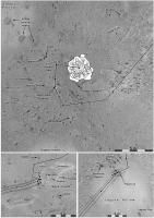
I am finishing up work on my Mars Atlas vol. 1 (up to Mars Express) and looking ahead at Vol. 2 (MER to present). All the text is done in draft form, so it's illustrations I am looking at. This is an experimental version of a map of early Spirit operations. The whole route would be mapped at larger scale (lower resolution) but sites of interest will be covered like this. Placenames are a problem. They were for Phoenix as well. Supposedly, they are accessible via the Analyst's Notebook at PDS, but that is filled with inconsistencies, with uncertainty regarding the identity of the named feature, etc. And looking ahead, I see that later in the mission most names are omitted from the Analyst's notebook. (Mission Ops people! Do us a favor, please keep and make available a proper record of the names you assign!) Phil
-------------------- ... because the Solar System ain't gonna map itself.
Also to be found posting similar content on https://mastodon.social/@PhilStooke Maps for download (free PD: https://upload.wikimedia.org/wikipedia/comm...Cartography.pdf NOTE: everything created by me which I post on UMSF is considered to be in the public domain (NOT CC, public domain) |
|
|
|
|
|
|
Apr 23 2011, 06:09 PM
Post
#34
|
|
|
Member Group: Members Posts: 194 Joined: 3-January 10 Member No.: 5156 |
QUOTE (Phil Stooke @ Apr 23 2011, 05:15 PM)  I am finishing up work on my Mars Atlas vol. 1 (up to Mars Express) and looking ahead at Vol. 2 (MER to present). All the text is done in draft form, so it's illustrations I am looking at. This is an experimental version of a map of early Spirit operations. The whole route would be mapped at larger scale (lower resolution) but sites of interest will be covered like this. Wonderfull news. I really like maps, and I really like this mission. Is there any release date of this Mars atlas? QUOTE (Phil Stooke @ Apr 23 2011, 05:15 PM) Placenames are a problem. They were for Phoenix as well. Supposedly, they are accessible via the Analyst's Notebook at PDS, but that is filled with inconsistencies, with uncertainty regarding the identity of the named feature, etc. And looking ahead, I see that later in the mission most names are omitted from the Analyst's notebook. Yes, I tried to make a list of the analyzed objects for Wikipedia. A full list of analyzed object would be useless, and which object would be really relevant to know about? So I gave up this list. -------------------- Need more input ...
|
|
|
|
|
Apr 23 2011, 06:22 PM
Post
#35
|
|
|
Solar System Cartographer Group: Members Posts: 10162 Joined: 5-April 05 From: Canada Member No.: 227 |
I will submit it to the publisher at the end of this year for release late next year. Phil http://publish.uwo.ca/~pjstooke/marsatlas.htm -------------------- ... because the Solar System ain't gonna map itself.
Also to be found posting similar content on https://mastodon.social/@PhilStooke Maps for download (free PD: https://upload.wikimedia.org/wikipedia/comm...Cartography.pdf NOTE: everything created by me which I post on UMSF is considered to be in the public domain (NOT CC, public domain) |
|
|
|
|
Apr 23 2011, 10:04 PM
Post
#36
|
|
|
Administrator Group: Admin Posts: 5172 Joined: 4-August 05 From: Pasadena, CA, USA, Earth Member No.: 454 |
QUOTE (Phil Stooke @ Apr 23 2011, 09:15 AM) Placenames are a problem... I'm curious how you're going about trying to figure out place names, in the absence of good historical records, because periodically I have to try to go back and figure out what something was called (or, more commonly, do the reverse action, finding an image of a place knowing only its name). I would usually begin by looking at the Pancam database to see if there was a targeted observation of the place of interest, at the rover updates on the mission website to see if it was mentioned in there, and at Salley's stories. Where else can you locate this information? Also, on MER there's a distinction between named locations and objects, and the names for the specific spots at those locations or objects where in-situ observations were made -- I hope you're not trying to track down all the names for those? This information is surely in some JPL database somewhere. I'd guess that if you had a specific set of things that were stumping you, a rover driver might be able to dig around and answer your questions, but that list could get kind of long for a 7-year mission.... -------------------- My website - My Patreon - @elakdawalla on Twitter - Please support unmannedspaceflight.com by donating here.
|
|
|
|
|
Apr 23 2011, 10:21 PM
Post
#37
|
|
|
Solar System Cartographer Group: Members Posts: 10162 Joined: 5-April 05 From: Canada Member No.: 227 |
Here are the Analysts' notebooks:
http://an.rsl.wustl.edu/mer/ And here are the site maps: http://an.rsl.wustl.edu/mer/merbrowser/bro...=map&m=MERA Select a site, play with the map dimensions, and you get a map of named features. You're right, I don't want every name, and I am mainly looking for names of objects like a rock or hollow, not a remote-sensing or IDD target. But it's not always easy to tell which object a name refers to. Phil -------------------- ... because the Solar System ain't gonna map itself.
Also to be found posting similar content on https://mastodon.social/@PhilStooke Maps for download (free PD: https://upload.wikimedia.org/wikipedia/comm...Cartography.pdf NOTE: everything created by me which I post on UMSF is considered to be in the public domain (NOT CC, public domain) |
|
|
|
|
Apr 3 2014, 03:34 PM
Post
#38
|
|
|
Member Group: Members Posts: 311 Joined: 31-August 05 From: Florida & Texas, USA Member No.: 482 |
Evidence for a Noachian-aged ephemeral lake in Gusev crater, Mars
summary: alteration of Comanche is consistent with low-temperature evaporites from near-surface water-rock solutions and equivalent to nearby Algonquin outcrops. http://geology.gsapubs.org/content/42/4/359.abstract |
|
|
|
|
Apr 8 2014, 05:35 PM
Post
#39
|
|
|
Member Group: Members Posts: 194 Joined: 3-January 10 Member No.: 5156 |
QUOTE (Marz @ Apr 3 2014, 04:34 PM) Evidence for a Noachian-aged ephemeral lake in Gusev crater, Mars Here the paper from lpsc of 2014: http://www.hou.usra.edu/meetings/lpsc2014/pdf/1739.pdf -------------------- Need more input ...
|
|
|
|
|
Apr 21 2014, 12:33 PM
Post
#40
|
|
|
Member Group: Members Posts: 282 Joined: 18-June 04 Member No.: 84 |
Just wondering here
 , but if mission planners had Mars Reconnaissance Orbiter - HiRISE and CRISM data in particular available to them when they were selecting a landing site for Spirit, do you think they would have selected a different site to Gusev Crater? , but if mission planners had Mars Reconnaissance Orbiter - HiRISE and CRISM data in particular available to them when they were selecting a landing site for Spirit, do you think they would have selected a different site to Gusev Crater?
|
|
|
|
|
Apr 21 2014, 01:39 PM
Post
#41
|
|
|
Founder Group: Chairman Posts: 14432 Joined: 8-February 04 Member No.: 1 |
That's a virtually unplayable and pointless game of what-if. The majority of the MER landing site selection process was driven by engineering anyway.
|
|
|
|
 |

|
Lo-Fi Version | Time is now: 16th May 2024 - 12:03 PM |
|
RULES AND GUIDELINES Please read the Forum Rules and Guidelines before posting. IMAGE COPYRIGHT |
OPINIONS AND MODERATION Opinions expressed on UnmannedSpaceflight.com are those of the individual posters and do not necessarily reflect the opinions of UnmannedSpaceflight.com or The Planetary Society. The all-volunteer UnmannedSpaceflight.com moderation team is wholly independent of The Planetary Society. The Planetary Society has no influence over decisions made by the UnmannedSpaceflight.com moderators. |
SUPPORT THE FORUM Unmannedspaceflight.com is funded by the Planetary Society. Please consider supporting our work and many other projects by donating to the Society or becoming a member. |
|