Printable Version of Topic
Click here to view this topic in its original format
Unmanned Spaceflight.com _ Spirit _ The West Valley Route
Posted by: Tesheiner Mar 18 2009, 12:00 PM
Here're the latest navcam pictures taken during sol 1850: http://nasa.exploratorium.edu/mars/spirit/navcam/2009-03-18/
Spirit is no longer stuck, but I think the attempt to go on top of HP via the NE path is finished and we are going to the West Valley. A pancam mosaic of the western route is planned for tosol.
Posted by: BrianL Mar 18 2009, 12:15 PM
Wagons ho! Yee-haw! 
Posted by: RoverDriver Mar 18 2009, 01:21 PM

t I think the attempt to go on top of HP via the NE path is finished and we are going to the West Valley. A pancam mosaic of the western route is planned for tosol.
That is correct. We are now trying to head west. Now, where's the on ramp for the I-40? ;-)
Paolo
Posted by: JayB Mar 20 2009, 02:21 PM
A nice DD from the latest batch of images
http://sidfishes.wordpress.com/?attachment_id=73
edit: sorry should have posted in West valley thread --- moved (thx 
Posted by: fredk Mar 20 2009, 11:02 PM
The weather at Gusev is looking a bit worse according to http://marsrovers.jpl.nasa.gov/mission/status_spiritAll.html#sol1845
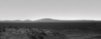
Posted by: Astro0 Mar 21 2009, 05:59 AM
Looks dusty out west. 
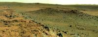
Sol 1851
|
Posted by: climber Mar 21 2009, 10:58 AM
Nice, Astro.
Is that more or less the drive direction?
Posted by: Tesheiner Mar 21 2009, 12:16 PM
By the right side of that mosaic, I would say. Next move is planned for today (sol 1854).
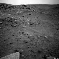
Posted by: Astro0 Mar 21 2009, 12:21 PM
Sol1850 Navcan pan.
I'll leave the drive direction to the tracking data gurus.
Tesh is right, it's a fair bet that it's straight ahead and then take a left at the next corner.
Posted by: RoverDriver Mar 21 2009, 01:38 PM
I'll leave the drive direction to the tracking data gurus.
Tesh is right, it's a fair bet that it's straight ahead and then take a left at the next corner.
Ok, let's do that then. ;-)
Paolo
Posted by: Ipparchus Mar 21 2009, 04:14 PM
Does anyone of you have any altitude and hazard maps of the Goddard-Von Braun area (red for dangerous areas etc)? The maps of this area make me feel quite pessimistic about the ability of Spirit to reach and study these targets. Von Braun has a high tilt (it seems to be difficult to climb it) and Goddard is a crater-shaped target and its tilt and soil slipperiness may make it a difficult to reach target and maybe a sand trap when Spirit tries to get out of it. If she fails to reach and study these targets what other options does she have (what other interesting targets are in this area)? 

Posted by: Geert Mar 21 2009, 05:42 PM
Problem with all these maps is that you have to work on a very small area and way below the resolution of most instruments (except HiRISE), which simply means that there is not so much data to crunch on and that greatly effects the accuracy of any predictions.
Variance map I posted earlier already, only increased it a bit to show von Braun / Goddard. Red shows area's with large variance in HiRISE brightness which might indicate a rough surface and thus dangerous driving. Blue is slightly better but still dangerous and lightgreen is the least bad.
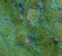
|
Below map is maybe interesting, this shows terrain type if I also take into account relative brightness in HiRISE (I would prefer to use CRISM for this, but it won't work on such a small scale). In this case colors do NOT have a specific meaning but they are only used to mark terrain with the same characteristics (brightness and variance). This means that there is a chance that all terrain with the same color, will show approximately the same driving characteristics.
|
Once again, don't assign any specific meaning to the colors themselves in above image, colors only note area's with the same characteristics, so if Spirit has been driving on terrain with a certain color, and futher on there is terrain with the same color, you might get the same driving experience there. Wish there was more available data (especially on hights/slopes/composition/etc) but apart from HiRISE almost all instruments have not enough resolution to produce trustworthy results in such a small area.
In the end it will be the eyes of Spirit itself with give the most information, together offcourse with the experience of the drivers.
Posted by: Astro0 Mar 22 2009, 02:50 AM
Astro0 said - "I'll leave the drive direction to the tracking data gurus."
Rover Driver said - "Ok, let's do that then."
Astro0 says: What I meant to say is that "I'll leave the educated guesses responding to a question about the drive direction to the tracking data gurus, and the ACTUAL driving we will whole-heartedly support and watch in admiring back-seat silence to the Expert MER Driving Team".
Posted by: RoverDriver Mar 22 2009, 06:13 AM
Rover Driver said - "Ok, let's do that then."
Astro0 says: What I meant to say is that "I'll leave the educated guesses responding to a question about the drive direction to the tracking data gurus, and the ACTUAL driving we will whole-heartedly support and watch in admiring back-seat silence to the Expert MER Driving Team".
What I meant to say is that the drive direction you were suggesting was exactly the intended (and now executed) path for the Sol 1854 drive ;-)
Paolo
Posted by: Tesheiner Mar 22 2009, 07:28 AM
> ... and now executed...
13m westwards and downslope. That's the longest drive for Spirit since a lot of time! Keep going.
Posted by: Tesheiner Mar 22 2009, 09:04 AM
Nice DD caught on action in today's navcam mosaic. 
|
Posted by: dilo Mar 22 2009, 10:13 AM
Wow! and is also a big one! 
Posted by: Tesheiner Mar 22 2009, 10:36 AM
Indeed. Anybody wants to give a try on calculating its diameter?
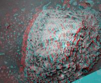
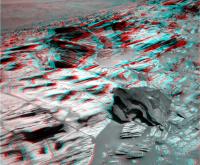
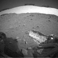
Posted by: Stu Mar 22 2009, 05:25 PM
Whoah... that's one seriously interesting rock Spirit was just looking at...
|

Posted by: mhoward Mar 22 2009, 05:42 PM
Was waiting for someone to post that. She had it in IDD range, but it looks like she decided to pass. Got places to go, apparently.
Posted by: eoincampbell Mar 22 2009, 05:53 PM
Sorry if discussed before, but are the DDs considered a threat as well as a benefactor to Spirit ?
Would one have enough force to dislodge or even keel over our rover?
I seem to remember a discussion concerning how "lightweight" the DDs were despite
their spectacular appearance... can't find that thread just now...
thanks in advance
Eoin
Posted by: fredk Mar 22 2009, 07:03 PM
Looking at some orbital images and trying to identify some features at comparable distances, I estimate that devil was about 1400 m away. That gives a diameter of very roughly 130 m. It could be quite a bit bigger if farther, smaller if closer.
I really hope that as we move closer to the plains we will be more likely to get hit by strong wind gusts. I understand that even a direct hit by a DD would be harmless to the rover, but would no doubt restore us to a showroom-floor sparkling-clean deck!
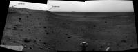
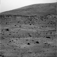
Posted by: jamescanvin Mar 22 2009, 07:12 PM
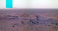
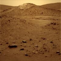
Beautiful view towards the west on sol 1852.
http://www.nivnac.co.uk/mer/index.php/spirit-sol-1852-western-route
James
Posted by: ngunn Mar 22 2009, 07:53 PM
Can we see the dust devil (or another one) there too? (Farther away, fainter, and a bit to the right of its position in the navcam view.)
Posted by: mhoward Mar 22 2009, 08:29 PM
There was a dust devil on the right side of that mosaic; it's subtle in this terrific natural-color version. Not related to the big one, though, since it was taken at a different time.
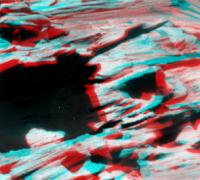
Posted by: SpaceListener Mar 23 2009, 01:38 AM
|
|
That picture shows a
. Hope that Spirit will be hit so by there.
Posted by: AndyG Mar 23 2009, 10:12 AM
And for the Father Dougal's amongst us: http://www.youtube.com/watch?v=GmU_q5xrnto

Andy
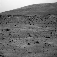
Posted by: ustrax Mar 23 2009, 01:46 PM
Indeed a beauty James! Have a doubt here, visiting your site, you make reference to Thera crater...I must be missing something here but aren't we looking in the opposite direction of it?

Posted by: Oersted Mar 23 2009, 02:04 PM
Would one have enough force to dislodge or even keel over our rover?
I seem to remember a discussion concerning how "lightweight" the DDs were despite
their spectacular appearance... can't find that thread just now...
thanks in advance
Eoin
The atmospheric pressure on Mars is only about one-hundredth of that on Earth, so no way a dust devil could tilt the rover. But if one could dislodge some of the dust on the panels that would be very welcome!
Posted by: MahFL Mar 23 2009, 02:09 PM
I hope the old girl is not out of breath after driving 13 m !
Posted by: jamescanvin Mar 23 2009, 02:29 PM
Yes your right - I was confused and in a hurry. Need more sleep...
Thanks for the complement and correction.
James
EDIT: Am I right in thinking that it is in fact, Grissom Hill?
Posted by: ustrax Mar 23 2009, 03:01 PM
Yes, you're right, that's Grissom and I must have entered in another dimension...one where ustrax corrects James... 
Posted by: dburt Mar 23 2009, 10:01 PM
Agreed. From that single image, it appears to have rock inclusions as well as numerous holes (vesicles) in it. I wonder if it might represent an ejected chunk of highly vesicular impact melt, rather than of lava. Hard to say...
-- HDP Don
Posted by: climber Mar 23 2009, 10:19 PM
If I read Eduardo's route map correctly we're about 5 meters north from Sol 767 drive trajectory.
I cannot see any weels marks
Posted by: James Sorenson Mar 23 2009, 11:24 PM
I cannot see any weels marks
It looks like Mars does not like her surface disturbed, WARNING: SHE WILL ERASE!!!
.
Posted by: dvandorn Mar 24 2009, 12:18 AM
Especially since it has rather obvious layering, which happens to lie parallel to the ground right now. Likely a serendipitous attitude.
The holes could be vesicles, or they could be remnants of inclusions that have either fallen out of the matrix or eroded out of it. The matrix is so highly eroded, especially in planes around its structural layering, that it's not easy to tell.
Looking at the rock in the anaglyph, I dearly want to turn it on its side and look into the crevices, to see the actual thickness of the layering and to try and see if there is any constructional relationship (i.e., alternating hard and soft layers) that would account for the rather obvious layer peel-aways.
-the other Doug
Posted by: dvandorn Mar 24 2009, 12:24 AM
. I have to say, I'm surprised that any of the tracks from either MER are still obvious, after that global dust storm they endured. I think it says a lot about the deposition mechanisms that some tracks have been erased, some partially erased, and some hardly erased at all. And that while some seem to have been swept clean, others are fully or partially buried.
There are obviously dust traps and dust scourers set up in the ground-level microclimate by the landforms and such; I wish we understood them well enough to be able to maneuver poor Spirit into a scouring location, ASAP!
-the other Doug
Posted by: Tesheiner Mar 24 2009, 06:33 AM
Its not the first time we address this topic about the lost tracks. While making my latest mosaic on this thread I was looking for that same old path too without luck.
Right about the NW corner we should (well... I hope) see some older wheel marks from when she was investigating HP for the very first time.
Posted by: Tesheiner Mar 24 2009, 10:07 AM
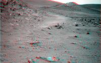
We are approaching the NW corner! Have a look to the latest mosaic made with today's navcam pictures (sol 1856).

|
BTW, a quick check to the rover's data tells us Spirit moved 21m! What a difference, if we compare with the (frustrating) attempts by the NE.
Posted by: jamescanvin Mar 24 2009, 10:28 AM
Nice.
I think I'm right in thinking that the two large dark rocks on the 'corner' of HP from this viewpoint are those at 'Gibson' where Spirit first arrived on sol 746/8.
EDIT: here is an old mosaic of mine from back then, showing the rocks I'm talking about.
http://www.nivnac.co.uk/mer/index.php/a746
Posted by: ustrax Mar 24 2009, 11:20 AM
13+21 not bad for a "crippled" rover...
That's our girl!
Posted by: MahFL Mar 24 2009, 12:49 PM
Can we have a route map update ?
Posted by: Tesheiner Mar 24 2009, 12:57 PM
Take it easy! It's lunch time here in Spain.
http://www.unmannedspaceflight.com/index.php?s=&showtopic=44&view=findpost&p=138326
Not so fast. This is the easy part mainly because we're driving downslope. If you have a look to the further route to Von Braun with Google Mars, the terrain becomes more complicated. It would be great to see these 10+ or 20+ in the future but I'm not so confident.
Posted by: RoverDriver Mar 24 2009, 01:34 PM
BTW, a quick check to the rover's data tells us Spirit moved 21m! What a difference, if we compare with the (frustrating) attempts by the NE.
Actually the data I have tells me 25.8m. A new record for driving with 5 wheels.
Paolo
Posted by: JayB Mar 24 2009, 02:18 PM
With these great long drags, is there any concern that we'll start wearing through the stuck wheel? I assume the aluminum is anodized and that would certainly help with abrasion resistance, but only to a point.
Probably not in the short term so I guess that's probably something to worry about for next year when we head for the rim of Gusev
Posted by: john_s Mar 24 2009, 02:43 PM
I'm imagining the thought experiment of taking one of those wheels and dragging it through some rocky dirt with 10 kg of weight on it (which I think is about the right load). Because we've only gone a few hundred meters(?) total since the wheel froze, my instincts agree with JayB that it would get nice and shiny but probably wouldn't suffer major structural damage.
John.
Posted by: MahFL Mar 24 2009, 04:43 PM
Ah a 3 hour lunch and a siesta ?
Posted by: Tesheiner Mar 24 2009, 05:13 PM
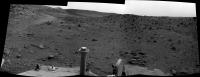
Not now but during summer vacations maybe.
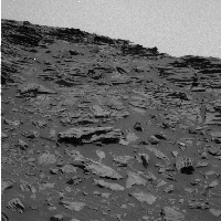
Back on topic: here's an annotated version of my previous mosaic pointing at some nearby features: Tsiolkovsky and Von Braun.
|
Posted by: RoverDriver Mar 24 2009, 05:23 PM
John.
Since Sol A 779 we drove about 859 m. I doubt the RF wheel has worn out significantly. It definitely is not like http://www.youtube.com/watch?v=MjNWzPfGWrU.
Paolo
Posted by: Floyd Mar 24 2009, 06:59 PM
That is a great movie Paolo, I memember watching it live on TV. It was very scary when you didn't know it would turn out.
Posted by: climber Mar 24 2009, 07:27 PM
Whoa! I didn't thought you could drive so strait on 5 weels
|
Posted by: ElkGroveDan Mar 24 2009, 07:47 PM
It looks like Spirit's trying to build a canal.
Posted by: climber Mar 24 2009, 07:51 PM
Schiaparelli, get out of Dan's body!
Posted by: Stu Mar 24 2009, 09:07 PM
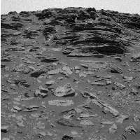
Lovely detail and depth of field in this new view as R2 - sorry, Spirit - heads through the Valley...
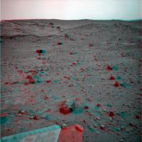
|
Posted by: Oersted Mar 24 2009, 09:18 PM
That is a keeper! - Classic image of the trenching action, and a shadow of Spirit thrown in for good measure.
Posted by: Astro0 Mar 24 2009, 09:31 PM
Nearly back to the original http://www.unmannedspaceflight.com/index.php?showtopic=1896&view=findpost&p=58801 spot!
I wonder if our footprints are still there?
Posted by: climber Mar 24 2009, 09:48 PM
Thanks Stu, we definitively need your (beautiful) anaglyphs there. Looks much more challenging tho

Posted by: BrianL Mar 24 2009, 10:01 PM
Well, if we can abrade it down to a nice, smooth surface, doesn't that solve part of the problem?
Posted by: RoverDriver Mar 24 2009, 11:05 PM
...
We have refined a set of self correcting arcs that seem to work quite well on this type of terrain. It gets more complicated when the terrain is not very uniform and less firm. The Sol 1854 and 1856 drives seem to have been on quite benign terrain.
Paolo
Posted by: ElkGroveDan Mar 24 2009, 11:22 PM
Probably just a few remains of shrimp tails and a couple of empty Fosters cans that you guys brought from Down Under.
Posted by: john_s Mar 25 2009, 12:25 AM
Paolo
Amazing video! I guess physics is a bit different at 200 mph than at 0.1 mph.
I wonder if anyone has considered going out in the arroyo at JPL and actually trying the wheel-dragging experiment? Could be a fun lunchtime project, though only if there are rover wheels, or equivalents, available for sacrifice...
John.
Posted by: Geert Mar 25 2009, 12:32 AM
I wonder if Mars will manage to erase this.
Posted by: dvandorn Mar 25 2009, 12:46 AM
There goes the concept of guarding against terrestrial contamination on Mars!
-the other Doug
Posted by: RoverDriver Mar 25 2009, 01:57 AM
I wonder if anyone has considered going out in the arroyo at JPL and actually trying the wheel-dragging experiment? Could be a fun lunchtime project, though only if there are rover wheels, or equivalents, available for sacrifice...
John.
Just outside the ISIL (the sandbox where we have the engineering model) there is a paved parking lot. I drove the testbed both in the Opportunity and Spirit configurations. In both configurations it sends chills down my spine. Sure, the different gravity field makes quite a difference, still it is not a pretty sight (or sound). In case you ask, this was done when I did the testing of driving with the IDD unstowed.
Paolo
Posted by: RoverDriver Mar 25 2009, 02:02 AM
No questions about it. Give it 30-50 years and all tracks from both vehicles will be erased. Even Purgatory and Tyrone. The RAT holes will last longer. Hopefully someONE will see them in person before they get erased. It is quite intimidating thinking that the holes I helped drill on Mars will last quite a bit more than I will.
Paolo
Posted by: Tesheiner Mar 25 2009, 09:24 AM
This is from http://marsandme.blogspot.com/2009/03/spirit-sol-80.html i.e. five years ago:
"... Basically the entire extended mission will be devoted to exploring the Columbia Hills. Of course, first we have to get there, or try to. They're planning 60 sols, plus 30 contingency sols, for that. Over the next few days, they'll try to work out how long it will take to drive there, and how long Spirit is likely to last. This will tell them how much time they have left over to do science at random targets of interest along the way."
Posted by: MahFL Mar 25 2009, 12:43 PM
Paolo
I think you reached perfection. Bravo !
Posted by: MahFL Mar 25 2009, 12:45 PM
This is a nice view.
http://qt.exploratorium.edu/mars/spirit/pancam/2009-03-25/2P290963279EFFB0HMP2352L2M3.JPG
Posted by: ElkGroveDan Mar 25 2009, 02:00 PM
Even on Earth you can find chiseled graffiti from hundreds of years ago in very exposed soft rocks. I can imagine a rat hole in basalt on Mars lasting a thousand years.
http://www.waymarking.com/waymarks/WM18ZQ
Posted by: fredk Mar 25 2009, 02:34 PM
Just to be clear, that's not the rim of Gusev, it's Grissom Hill and a few other features well within Gusev. But it is a spectacular view!
Posted by: Oersted Mar 25 2009, 03:26 PM
The stuck wheel hasn't (just) been a problem, but has been the reason for probably the most important discovery from Spirit so far!
Posted by: ilbasso Mar 25 2009, 05:52 PM
...or from 4,600 years ago...
http://i407.photobucket.com/albums/pp155/texwardo/Cairo%202009/IMG_3734.jpg
Posted by: climber Mar 25 2009, 06:14 PM
15.000 years: http://www.culture.gouv.fr/fr/arcnat/lascaux/en/index3.html
Posted by: ilbasso Mar 25 2009, 06:35 PM
Although maybe a little better protected in the cave! And we couldn't get the MERs down in a cave anyway...they're getting precious little sunlight as it is.
Posted by: HughFromAlice Mar 25 2009, 07:20 PM
I've often wondered how long it would take to erase the wheel tracks! Knowing the rate at which they are being erased in different soil types, wind regimes etc could give a lot of very interesting info on geological time frames. In fact, just from the tracks themselves there must be a lot of info (additional to the dragged wheel discoveries).
Is anyone studying this - any papers on it - earlier comments in UMSF - or any one got any comments on this?
Posted by: RoverDriver Mar 25 2009, 07:28 PM
Is anyone studying this - any papers on it - earlier comments in UMSF - or any one got any comments on this?
We are getting OT here, so if the Admins want to remove this post please do so. After Opportunity left Duck Bay we stopped at a location where tracks from sol 950-952 and 1291 were visible. The 95x tracks were very degraded from the dust storm of July-August 2007. I believe NAVCAMs and PANCAMS were taken of those tracks and probably this was the best opportunity (no pun intended) to study the track appearance in time.
Paolo
Posted by: fredk Mar 25 2009, 08:34 PM
There were great pictures and some discussion in the Leaving Victoria Crater thread, http://www.unmannedspaceflight.com/index.php?s=&showtopic=5372&view=findpost&p=124921
Also, we saw Spirit's tracks start to get obscured after the big dust storm, check out the thread http://www.unmannedspaceflight.com/index.php?s=&showtopic=4309&view=findpost&p=94798
Posted by: Astro0 Mar 25 2009, 11:29 PM
Back in the West Valley...
An enhanced view of Grissom Hill and beyond.
|
Posted by: ustrax Mar 26 2009, 08:09 AM
Hmm...here wondering...how far is that?
Posted by: jamescanvin Mar 26 2009, 08:35 AM
About 7.5km from the landing site.
http://marsrovers.nasa.gov/gallery/press/spirit/20040127a/HorizonHillsApollo_br2.jpg
Add maybe 1km to that from our current position.
http://marsrovers.nasa.gov/gallery/press/spirit/20040127a/GusevMapApollo_br2.jpg
A little far for a 5 wheeled rover I'd say. 
Posted by: Tesheiner Mar 26 2009, 08:59 AM
... producing 230 Wh/day. A bit difficult, yes.
Now, back to the current activities, tosol drive was about 12 meters SSW. Pictures should be in the web soon.
Posted by: mhoward Mar 26 2009, 03:03 PM
http://www.flickr.com/photos/marscat/3387755856/sizes/l/
Navcam anaglyph mosaic facing east, sol 1858. 180x90 degree cylindrical projection.
http://mmb.unmannedspaceflight.com/MERA1858NavcamAnaglyph.mov (2.9MB)
Looks like the rover drivers have some challenging terrain ahead.
Posted by: Tesheiner Mar 26 2009, 03:06 PM
This navcam picture is pointing to the site Spirit was during the first science campaing.
http://nasa.exploratorium.edu/mars/spirit/navcam/2009-03-26/2N291311184EFFB0LTP0747L0M1.JPG
Compare it with James' mosaic http://www.unmannedspaceflight.com/index.php?s=&showtopic=5901&view=findpost&p=138320.
Posted by: jamescanvin Mar 26 2009, 03:26 PM
Might also be a good time to repost the full Gibson Pan:
http://www.nivnac.co.uk/mer/index.php/a748
Posted 26/02/2006 - 37 months ago. Back when Spirit was young a sprightly and able to climb HP here.
And the colour anaglyph
http://www.nivnac.co.uk/mer/index.php/a0748glyph
Posted by: BrianL Mar 26 2009, 03:34 PM
Well, at least one rover is on the move. I really hate it when they let the scientists out of their cages.
Posted by: Tesheiner Mar 26 2009, 04:17 PM
<back-seat mode on>
The West Valley has an E-W slope, perpendicular to the planned path, so I would suggest to keep Spirit as much as possible to the left (near HP) to avoid losing altitude.
<back-seat mode off>
Posted by: Marz Mar 26 2009, 06:17 PM
I'd agree that hugging Home Plate's base seems like the best drive path through west valley. However, is Tiolkovsky a different composition from Home Plate, or is it part of the same formation that is just split by the valley? If it's different, maybe it's worth closer examination?
Posted by: RoverDriver Mar 26 2009, 07:26 PM
The West Valley has an E-W slope, perpendicular to the planned path, so I would suggest to keep Spirit as much as possible to the left (near HP) to avoid losing altitude.
<back-seat mode off>
That's what we will try to do. The thing to balance is the soil type. Near HP base there are several locations where fine dust has accumulated and as we have seen this type of terrain can lead to trouble.
Paolo
Posted by: climber Mar 26 2009, 08:03 PM
IIRC, one of the reason for not using the West Valley Route was because we didn't have enough visual informations as compared to crossing HP or using the East route. Not mentioning the laters were shorter, etc...
Once again, looking at Eduardo's map, I'd said that I guess we have very good coverage (even from to of HP) around Gibson then again around Tartarus; this leads to sol 1363 drive that will join sol 1350 way point.
Either I missunderstood or this is not enough to call the route "known enough" for a Rover Driver standard.
Anyway, even if we can use the pictures we have down to sol 1350 way point or so, this will cover half the distance to Von Braun.
Posted by: climber Mar 26 2009, 08:18 PM
By the way, here is a link from Ant103 new and very nice web site that shows a part of the route: http://www.astrosurf.com/merimages/Spirit/Panoramas_couleur/Medres/Sur%20Home%20Plate%20Sol758-medres.jpg
Posted by: Ant103 Mar 27 2009, 01:11 AM
Hé hé hé Climber
My version of the West Valley route in color of the Sol 1851
http://www.astrosurf.com/merimages/spirit-2009.html#last
Posted by: RoverDriver Mar 27 2009, 05:42 AM
Once again, looking at Eduardo's map, I'd said that I guess we have very good coverage (even from to of HP) around Gibson then again around Tartarus; this leads to sol 1363 drive that will join sol 1350 way point.
Either I missunderstood or this is not enough to call the route "known enough" for a Rover Driver standard.
Anyway, even if we can use the pictures we have down to sol 1350 way point or so, this will cover half the distance to Von Braun.
Of all the routes to VB/G the west valley route was the one that had most coverage which indicated some narrow passages (meaning good driving terrain in some areas might be narrow). Aerial imagery seem to indicate that the terrain N and NW of VB can be difficult to traverse. Unfortunately there is no way to get surface imaging before the rover actually gets there. ;-)
And then you know that rover drivers don't ever have enough data about traversability. Not even after driving on it. ;-)
Paolo
Posted by: climber Mar 28 2009, 08:09 PM
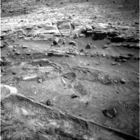
I think I've found sol 743 weels tracks
Visible for a few meters before and after these two black rocks in the first 1/4 from the back of the picture a little bit on the right from the center. Agree?
|
Posted by: Tesheiner Mar 28 2009, 09:30 PM
Good catch, climber!
Really, really difficult to see but they are actually there.
|
http://qt.exploratorium.edu/mars/spirit/pancam/2009-03-28/2P291398034EFFB0LTP2355R2M1.JPG
Posted by: alan Mar 28 2009, 10:09 PM
Posted 26/02/2006 - 37 months ago. Back when Spirit was young a sprightly and able to climb HP here.
And the colour anaglyph
James, did you do a color 3D version of the West Valley Pan, sols 1366-1369?
Posted by: Tesheiner Mar 29 2009, 10:02 AM
Today was driving sol and I just checked the pancam web to find out that Spirit did another 20+ meters move, definitely entering the West Valley.
Looking forward the pictures to confirm it. Meanwhile, I'll make a preliminary route map update... http://www.unmannedspaceflight.com/index.php?s=&showtopic=44&view=findpost&p=138535.
Posted by: Floyd Mar 29 2009, 02:02 PM
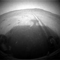
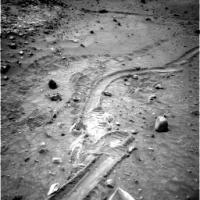
The Images are down and look at this http://qt.exploratorium.edu/mars/spirit/forward_hazcam/2009-03-29/2F291581504EFFB0OAP1214R0M1.JPG.
[Temp residence: Old Swan Hotel, Harrogate, North Yorkshire]
Posted by: fredk Mar 29 2009, 03:31 PM
Nice job spotting the tracks, climber! I think what helps their visibility here is that we're looking straight "up" the tracks, so they are heavily foreshortened, so a long stretch of tracks is compressed into a short span of the image.
The exposed white stuff shows nicely again how we completely missed this material during our previous pass through here in the mid sol 700's with six good wheels. Given their interest in the white stuff we exposed on the north side of HP, I wonder if we'll be pausing for a bit to take a closer look here?
Posted by: JayB Mar 29 2009, 04:03 PM
" look at this White Trench. "
that's an amazing shot... what is that... 15-20 meters. wow
Given how valuable the broken wheel has turned out to be wonder if the MSL team has decided to add another piece of equipment ... the DATT (Drive Actuated Trenching Tool)
(actually I'm serious.. a stick that drags while driving would seem to be a really good idea)
Posted by: Doc Mar 29 2009, 04:13 PM
It seems the distribution of the white material is more widespread than originally thought (maybe it surrounds all of HP). It would be interesting to see if Goddard is also surrounded by the material if indeed it is a volcanic feature.
Posted by: Phil Stooke Mar 29 2009, 07:59 PM
I'm responding to Alan's route map, but like a good UMSFer I'm posting it here to keep chat out of the map thread.
Alan, your map is especially useful, I think, for its view of the slopes ahead of us. It looks as if a drive on the WEST side of von Braun would drop the rover too much, so it might have trouble coming back up on the south side (not to mention, the south side would be bad for sun until deep summer). The best route might be to get around Home Plate and then try to get into the valley between VB and Goddard. I've always thought that the stratigraphy at the SW corner of Home Plate might be the most complete section - it appears to be the highest part of the edge. If it's not too blanketed with debris we might see layering better there than at the NW corner.
Of course, we need the overhead map as well... an oblique view like this loses too many places behind the topography.
EDIT: fredk (next post) was of course right - WEST side of VB. I corrected it above. I was looking in the wrong direction... duh...
Phil
Posted by: fredk Mar 29 2009, 09:08 PM
Just to be clear, I assume you mean a drive on the west side would drop the rover too much.
It sounds like a good strategy. Basically, since we can presumably always travel downslope, it makes sense to keep as high as you can for as long as you can (as Tesheiner mentioned regarding the drive through West Valley). That way we always can head downslope once we're done with the higher regions.
I don't recall hearing it at the time, but this would've been another advantage of the "over HP" route - we would've ended up quite high. Of course that route turned out to be not doable.
Posted by: Oersted Mar 29 2009, 09:34 PM
They will be able to just put the brakes on one wheel I hope, and will use MSL trenching, I hope, if, sorry, WHEN she lands safely on Mars.
That is indeed an amazing white trench Spirit just dug there. I guess it will be visible with HiRise! Hope they'll sniff it.
Posted by: mhoward Mar 29 2009, 10:42 PM
http://www.flickr.com/photos/marscat/3396051421/sizes/l/
Pancam anaglyph view south, Spirit sol 1861
Posted by: Astro0 Mar 29 2009, 11:14 PM
In the anaglyph it looks like that on either side of the potential drive path there are some small hollows.
Tartarus Warning!!!!  Maybe not, but this is going to present some interesting times for the MER Precision Driving Team.
Posted by: alan Mar 30 2009, 12:18 AM
Some views of the potential Tarturi
from sol 758
|
and from sol 1374

|
Posted by: alan Mar 30 2009, 12:26 AM
And a look ahead to the other side of West Valley and the path to von Braun
|
|
ETA: from sol 1350
Posted by: RoverDriver Mar 30 2009, 03:10 AM
Tartarus Warning!!!!
Maybe not, but this is going to present some interesting times for the MER Precision Driving Team.Yep. I think the 20+ meter drives are a thing of the past. We'll see where and how far we can go now. Keep your eyes peeled.
Paolo
Posted by: Shaka Mar 30 2009, 05:48 AM
...peeled and perspicacious, Paolo!
Unless we spot some dusty puddles in our path, I'd say we should just brush the edge of the HP talus exposures with our 'easterly wheels' (starboard side?). There the fine sediments should be shallowest - least likely to swallow us up  - and keep us close to the HP strata we want to study. Of course, it's possible that some PIs will want to plow up the deep sand in the middle of West Valley looking for 'delicious siliceous deposits'. (De gustibus non disputandum est.)
But if we get bogged down, we should all be allowed to say "We told you so!"
Posted by: Astro0 Mar 30 2009, 06:19 AM
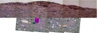
Marked in red, a best estimate of the Sol1861 rover position. Any takers?

|
Astro0
Posted by: Geert Mar 30 2009, 07:05 AM

|
This is about the closest I can get while still convincing myself that I'm not only tracking garbage.
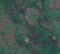
Above image is made by combining 2 HiRISE images (to as much as possible eliminate shadows and garbage) and then asking the computer to mark area's with similar average relative brightness and variance. Resolution is 12.5 cm/pixel and grid is 3 meters.
Note the colors do NOT have any meaning in themselves, they only mark area's which 'look' the same to the software, in other words colors mark areas which have the same average brightness and the same variance. Keep in mind that slopes will also result in differences in brightness, so an east-facing slope will often get a different color from a west-facing slope even if it is in fact the same 'sand'.
I think what we can say is that we have been driving on 'brown' and 'dark purple' without getting stuck, so that's probably okay, but there is some 'lightblue' ahead which we have never driven on with only a small strip of 'okay' brown passage. "Unknown" colors MIGHT be dangerous or at least require attention.

|
On a scale of 25 cm/pix but using the same color-set this is the remaining area from West Valley to VB/GD, once again colors are only used to mark terrain with the same average brightness and variance but have no meaning in themselves. In order to mark colors as 'dangerous' or 'safe' I would have to check all measured terrain with terrain where Spirit has been driving previously and them mark it with a value-indicator (more or less what Mike has been doing for Oppy on Meridiani) and even then you can only state something about 'known' terrain.
Posted by: jamescanvin Mar 30 2009, 07:47 AM
No, just the 2D colour: http://www.nivnac.co.uk/mer/index.php/a1366
I'll try and do a 3D version as we are heading back that way. It was only taken using one filter with the right pancam so colour 3D will be tough, but at least it is R1 (blue) so it's not impossible.
Posted by: jamescanvin Mar 30 2009, 08:03 AM
Geert, I'm not sure that analysis shows meaningful differences in terrain. You seem to have ended up with a similar range of colours for both the terrain on top of HP and that surrounding it - something we know from ground truth to not be the case.
Posted by: djellison Mar 30 2009, 09:46 AM
Sorry Geert - I'm with James. Your analysis doesn't achieve anything when compared to ground-truth.
Doug
Posted by: Ant103 Mar 30 2009, 09:59 AM
Distant dust devils captured on Sol 1856

|
Posted by: Geert Mar 30 2009, 11:00 AM
I was afraid of that myself also already, as mentioned earlier its almost impossible to do anything meaningful from orbital images at such small ranges, you end up chasing ghosts ;-)
The only truth will need to come from the eyes of the rover itself.
Posted by: Stu Mar 30 2009, 11:37 AM
Phew! It's not just me then! A few times I've looked at them and thought "But if that colour is meant to be rocky, how come it doesn't look rocky on the pictures?" then thought maybe I was just being dumb and missing something slap-across-the-face obvious or just not interpreting the images correctly. But for some time now I've been thinking that - and I mean absolutely no disrespect here to the people who spend so much time working so hard on making them - these "terrain mapping" images are now a little bit irrelevent, especially when it's stated that the colours don't actually represent any ground truth.
Posted by: MahFL Mar 30 2009, 01:00 PM
Visible for a few meters before and after these two black rocks in the first 1/4 from the back of the picture a little bit on the right from the center. Agree?
By "back" do you mean bottem ? if so then thats the front ! right ?....lol. Took me a while to spot them, as I was looking in the wrong place.
Posted by: Geert Mar 30 2009, 01:29 PM
Colors can only mean one position has the same relative brightness and the same variance as an other position with the same color, there is absolutely no way they can say anything more be course that information simply is not in the HiRISE data. CRISM and THEMIS tell you a LOT more about the surface, but both have a resolution which is far and far less then what we need here, so you can't use them in this case. I gave it a try to see if there was any way we could get any information from HiRISE when working on this small scale but I was already very skeptical about it, it was a nice exercise in chasing ghosts
Posted by: Stu Mar 30 2009, 01:42 PM
It was definitely worth a try, yep! Not taking anything away from the effort or intentions. I think we can leave those particular ghosts alone now tho, and just enjoy the spectacular real views
Speaking of which, hoping we're soon going to get a second look at my very favourite martian rock, McKay (lower right), last seen around Sol 747...
|
Posted by: climber Mar 30 2009, 03:43 PM
I thought I had to give hard time to "you" since I had such hard time to spot them
Actually, this was a kind of "team work" since I'll never have found them if I didn't know where to look i.e. without the route map
Posted by: Stu Mar 30 2009, 03:50 PM
I was going to say this dirt was "disturbed" but it looks positively deranged to me...
http://stugallery.files.wordpress.com/2009/03/spirit-mar-30b.jpg
Posted by: Ipparchus Mar 30 2009, 04:16 PM
Does anybody know if the rovers could, still, operate after the batteries' failure? Sqyures had said that " their lifetime is 6 to 7 years, theoretically"... Could the rovers hold on in the next martian winter and how long after that?
Posted by: mhoward Mar 30 2009, 04:33 PM
http://www.flickr.com/photos/marscat/3399215938/sizes/o/
Pancam false color, Spirit sol 1848
The multi-colored soil in this one makes me sit up and wonder what's going on here. (With no science background and no real data, though, my actual reaction is closer to "ooh, pretty.")
Posted by: climber Mar 30 2009, 05:04 PM
Well, as the french humorist Pierre Dac would have said (approx translation): when I see what I see and I when I know what I know, I'm glad to think what I think.
Posted by: ElkGroveDan Mar 30 2009, 05:16 PM
Are you sure we aren't looking at a Nevada mountainside? This looks a whole lot like some of the excavation pits (in REAL color) that I saw two weeks ago in Esmeralda Co.
Posted by: fredk Mar 30 2009, 05:19 PM
That was a stunning outcrop. I'd like to see if some of the most precarious, narrow pinnacles of rock are still standing, such as this one towards the top of your image:
|
My guess is it would take very many dust storms to bring even the thinnest of these guys down.
Posted by: BrianL Mar 30 2009, 05:41 PM
I'm completely confused now (be nice!).
Is http://nasa.exploratorium.edu/mars/spirit/navcam/2009-03-29/2N291579346EFFB0OAP1985L0M1.JPG the likely direction of travel (which I thought would keep them close to HP), or is Spirit heading toward http://nasa.exploratorium.edu/mars/spirit/navcam/2009-03-29/2N291579688EFFB0OAP1985L0M1.JPG, which seems more in line with the current direction of travel? Or am I totally disoriented?
Posted by: climber Mar 30 2009, 05:49 PM
We can only drive backward. Does this help?
Posted by: fredk Mar 30 2009, 05:56 PM
I'd say the first image you posted. We should be sticking close to HP if we can.
Posted by: RoverDriver Mar 30 2009, 06:05 PM
Is http://nasa.exploratorium.edu/mars/spirit/navcam/2009-03-29/2N291579346EFFB0OAP1985L0M1.JPG the likely direction of travel (which I thought would keep them close to HP), or is Spirit heading toward http://nasa.exploratorium.edu/mars/spirit/navcam/2009-03-29/2N291579688EFFB0OAP1985L0M1.JPG, which seems more in line with the current direction of travel? Or am I totally disoriented?
The general drive direction is south (the first image), but we are not sure we can drive in that direction. The rock that is about 5 meters behind the rover and is visible in the NAVCAM frame is too big to go over or straddle, so we have to go around it. In the meantime we will stop for a few sols to sniff what the RF wheel has dug up.
Paolo
Posted by: BrianL Mar 30 2009, 06:26 PM
Which sol was this taken on? Sorry, I lack the talent that lets people look at their surroundings and deduce their position on a map.
Posted by: Stu Mar 30 2009, 06:43 PM
If you like those, you'll LOVE these...
|
Posted by: climber Mar 30 2009, 07:24 PM
Rolling hills, DD, weels tracks, we are .... in Arica North Chile january this year.
I couldn't catch the best DD, the one that realy looked like what Spirit shows us these days, but I was impressed how the scenary looked so "familiar"

|
Posted by: Tesheiner Mar 30 2009, 07:52 PM
Familiar, indeed. What about in B&W?

|
Mmm, this looks to be one of those mosaics taken at the southern side of HP. May I say sol 1350 or so?
Posted by: Ant103 Mar 30 2009, 08:10 PM
Very familiar Climber
And what about a little "navcam raw jpegisation" ?

|
Posted by: climber Mar 30 2009, 08:49 PM
Thanks Eduardo and Damien!
I'm sure Paolo would have prefered getting this kind of terrain to get to VB
Posted by: alan Mar 30 2009, 11:43 PM
Sol 1350, there were also two pancam mosaics taken on sols 1349 and 1351 as part of a long baseline stereo pair.
Posted by: Zeke4ther Mar 31 2009, 04:49 AM
Cooool!
Posted by: climber Mar 31 2009, 04:54 PM
I have the feeling that this could become one of the emblematic pictures of the whole Mer missions: http://nasa.exploratorium.edu/mars/spirit/navcam/2009-03-31/2N291756808EFFB0OAP1951L0M1.JPG
Posted by: jamescanvin Mar 31 2009, 06:11 PM
As requested.
http://www.nivnac.co.uk/mer/index.php/a1366_glyph
Posted by: mhoward Mar 31 2009, 06:34 PM
That's too cool, James. Tonight I'm going to have to try to whip up some anaglyph perspective views of West Valley from the PDS images, to offset the coolness. (Adding: I mean that in that sense that anything I produce will probably be less cool, if only because it won't be in color.)
Posted by: briv1016 Mar 31 2009, 06:43 PM
Here we go again. (bright soil)
http://marsrovers.jpl.nasa.gov/gallery/press/spirit/20090330a.html
Posted by: djellison Mar 31 2009, 07:01 PM
A couple of fairy crude anims of recent driving (one large, one small)

|

|
Posted by: climber Mar 31 2009, 07:35 PM
The rear weels (the one that drive first) do not appear to be sinking at the actual position.
The RF sank much more than a few meters before.
The LF didn't sink at any stage.
This is not consistent to me. Any idea?
Posted by: mhoward Mar 31 2009, 07:40 PM
Here we go again, indeed: http://www.planetary.org/blog/article/00001900/
Posted by: djellison Mar 31 2009, 08:02 PM
$@&*
Keep an eye on http://www.msss.com/msss_images/latest_weather.html
Posted by: elakdawalla Mar 31 2009, 08:03 PM
Be careful: "planet-encircling" and "global" are different animals. So far the evidence only shows dust activity in the south, though it's creeping northward. Global circulation patterns are disturbed, but so far the dust is confined to the south. And this hasn't been corroborated by image data yet.
Posted by: imipak Mar 31 2009, 09:11 PM

How strong is the correlation between atmospheric temperature increases and dust storms?
Posted by: Deimos Apr 1 2009, 03:25 PM
Spirit has seen elevated opacity (>1) for 2 weeks now. It's about 1.2 and falling, but you can't extrapolate the trends on the ground in storms. BTW, Opportunity has seen over 1.5 optical depths in the same time frame, and also is at 1.2 and falling.
Posted by: mhoward Apr 1 2009, 05:03 PM
http://www.flickr.com/photos/marscat/3404945784/sizes/o/in/photostream/
http://www.flickr.com/photos/marscat/3404134933/sizes/l/
"Kit Carson" - Pancam L257 false color, Spirit sol 1864
(I know the Pancam doesn't match up perfectly with the Navcam background; this is just a quick MMB screen grab)
Posted by: fredk Apr 1 2009, 11:49 PM
From the latest Planetary Society update:
I had wondered about that sequence of pancam images looking to the NW, for example:
http://marsrovers.jpl.nasa.gov/gallery/all/2/p/1859/2P291398034EFFB0LTP2355L2M1.JPG
On another topic, I love this little hill off to the west:
http://marsrovers.jpl.nasa.gov/gallery/all/2/p/1860/2P291490241ESFB0LTP2561L5M1.JPG
I'm sure the more geologically-minded can correct me, but perhaps the odd rocks at the very peak are remnants of a harder material that originally capped the hill von Braun-style, and has almost completely eroded away now?
Posted by: Tesheiner Apr 2 2009, 06:14 AM
http://marsrovers.jpl.nasa.gov/gallery/all/2/p/1860/2P291490241ESFB0LTP2561L5M1.JPG
"Pioneer Mound", it's named.
Posted by: climber Apr 3 2009, 09:24 PM
This is the big rock avoidance manoeuvre (see Paolo post) which also put us on much firm soil as opposed to the "sandy" area closer to HP.
This assume that we're going to rotate ~90° around the RF: http://nasa.exploratorium.edu/mars/spirit/navcam/2009-04-03/2N292023025EFFB0OZP0703L0M1.JPG and then strait for a few meters.
Back seat driver guess...
Edited: I'm in a Ustrax's mood so, here is my real guess

|
Posted by: mhoward Apr 3 2009, 10:37 PM
http://www.flickr.com/photos/marscat/3409677219/sizes/o/
132x82 degree anaglyph cylindrical projection, Spirit sol 1866, looking due south.
Posted by: RoverDriver Apr 3 2009, 10:51 PM
[quote name='climber' post='138729' date='Apr 3 2009, 02:24 PM']
...
Back seat driver guess...
Edited: I'm in a Ustrax's mood so, here is my real guess
...
That's a pretty good guess! As a hint, unless we really have to, we try to have drive segments that are as straight as possible. The reason is that whenever you have a turn, not only you need to make sure you turn the correct amount, but also that the rover is in the correct position to turn. We have means to check these things of course, but they are expensive, they require the use of Visual Odometry which runs pretty slow.
Paolo
Posted by: mhoward Apr 3 2009, 11:05 PM
Paolo, I always wondered, is it difficult to keep her driving straight on this kind of terrain, especially minus one working wheel? Does she tend to veer off? I mean obviously the last few drives looked very good, but now it looks like we might be getting back to some seriously challenging terrain again.
Posted by: eoincampbell Apr 4 2009, 12:01 AM
Would Spirit be able to peek over and image much of Tartarus and tracks, or what's left of them?
Posted by: RoverDriver Apr 4 2009, 05:09 PM
It is not really difficult, now that we have a sequence already built that keeps the rover on track. The RF wheel makes the rover drift to the right. The exact amount of the drift depends on the terrain we are driving. There an instrument on board the rover, called IMU (Inertial Measurement Unit) that keeps track of the rover attitude (roll, pitch and heading). While the rover moves the IMU measures the change in heading. After a step the rover compares its own heading vs the desired direction and applies a heading correction for the next step. This driving technique works even without VO and while the sequence is not very easy to understand, it works quite fast for Martian standards, theoretically about 80m/h.
From time to time we adjust the heading correction values depending on the terrain, but pretty much the sequence stays the same.
Paolo
Posted by: RoverDriver Apr 4 2009, 05:10 PM
I'm not so sure *I* would like to see Tartarus again
!!Paolo
Posted by: mhoward Apr 4 2009, 05:48 PM
Thanks, Paolo; that makes sense. With respect to Tartarus, I think it's above Spirit's eye level now, but I could be wrong. Looking forward with some trepidation to see what happens in West Valley...
Posted by: fredk Apr 4 2009, 06:14 PM
Long-baseline stereo view looking at Pioneer Mound and the plains beyond, sols 1859 and 1861:

|
As usual, movement is not exactly orthogonal to the line of sight, so there are distortions that are difficult to correct. Eyestrain/headaches may result!
Posted by: climber Apr 4 2009, 09:21 PM
May be this illustrate Paolo explanations:
|
|
Posted by: Ant103 Apr 4 2009, 09:35 PM
The view of Pioneer Mound on Sol 1865, in normal and stereo
http://www.astrosurf.com/merimages/Spirit/2009/2P291928347EFFB0OAP2553LCoul.jpg
http://www.astrosurf.com/merimages/Spirit/2009/2P291928347EFFB0OAP2553LCoul-ana.png
Posted by: mhoward Apr 5 2009, 08:41 PM
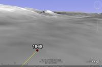
It was hard not to post this in the route map thread, but it looks like Spirit's sol 1868 went very well! I'm happy, because considering it was a bit uphill, plus it seems like just the other day she was wallowing in sand - well, I wasn't expecting this one to go nearly so well. Here's a little celebratory screen grab based on the tracking data - I'm not sure how exact this is yet, the Navcams will help.
http://www.flickr.com/photos/marscat/3415879582/sizes/o/
BTW, love the color anaglyph, Ant.
P.S. I'm raising a glass to the MER team right now. Nice drive!
Posted by: Stu Apr 5 2009, 08:45 PM
Great drive! That's our gal!
Passed this interesting rock on the way...

|
Posted by: climber Apr 5 2009, 09:00 PM
Spirit has covered about 1/3 of the distance to VB since the decision to use the west valley has been taken.
Even if troubles could come ahead, I was not expecting such a fast pace. Good on you rover drivers.
Posted by: fredk Apr 5 2009, 09:21 PM
Good news indeed! And we now have our final destination in view of even hazcam:
http://qt.exploratorium.edu/mars/spirit/rear_hazcam/2009-04-05/2R292205857EFFB0S0P1311R0M1.JPG
Posted by: Tesheiner Apr 5 2009, 09:31 PM
And don't forget she's doing all that with less then 250 Wh!
> Passed this interesting rock on the way...
Named after http://en.wikipedia.org/wiki/Álvar_Núñez_Cabeza_de_Vaca.
Posted by: RoverDriver Apr 5 2009, 09:57 PM
Even if troubles could come ahead, I was not expecting such a fast pace. Good on you rover drivers.
Don't get excited. The most difficult part is still to come. We knew that this terrain was relatively easy. Good that this week I'm switching to the other side of the planet.
Paolo
Posted by: dot.dk Apr 5 2009, 10:04 PM
So you're saying that there is a rover that needs a DRIVER soon?
Posted by: Floyd Apr 6 2009, 10:18 PM
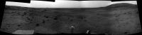
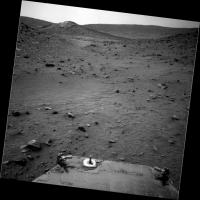
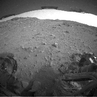
Behold Von Braun--http://qt.exploratorium.edu/mars/spirit/pancam/2009-04-06/2P292281357EFFB100P2359L2M1.JPG. Path forward looks quite reasonable.
Posted by: Stu Apr 6 2009, 11:14 PM
Wow... looking at this there are some seriously - SERIOUSLY - exciting views to come...

|
Posted by: elakdawalla Apr 6 2009, 11:23 PM
Quick'n'dirty pan. Spirit's getting fun again!

|
--Emily
Posted by: centsworth_II Apr 7 2009, 12:24 AM
The most -- maybe the only -- interesting part of Von Braun is its cap. But I'm worried that Spirit won't be able to get to it.
Posted by: fredk Apr 7 2009, 12:59 AM
Anyone know if sol 1869 was supposed to be a drive sol? We had F and R hazcam frames, but no movement.
Posted by: RoverDriver Apr 7 2009, 01:11 AM
--Emily
She's always fun to drive! Anybody can put a brick on the accelerator, but to harness 250Wh into something useful, that takes skills! ;-) ;-)
Paolo
Posted by: RoverDriver Apr 7 2009, 01:12 AM
Well, even if we get half way to the cap we might get some interesting remote sensing measurements.
Paolo
Posted by: elakdawalla Apr 7 2009, 01:54 AM
Been reading Scott's blogs lately?
From http://marsandme.blogspot.com/2009/04/spirit-sol-87.html...I'm not into the whole inter-rover rivalry thing, but that cracks me up.
Posted by: tedstryk Apr 7 2009, 02:34 AM
Paolo
And hopefully they can find a broken off piece of the cap somewhere if it can't make it.
In the mean time, it would be really cool to take a color version of that panorama looking up the valley - the composition is phenomenal!
Posted by: Astro0 Apr 7 2009, 03:35 AM
Tedstryk - "...it would be really cool to take a color version of that panorama looking up the valley..."
Cheat colour version.
|
Yes, hopefully a quick colour panorama will come along.
Imagine the views yet to come
Posted by: centsworth_II Apr 7 2009, 06:30 AM
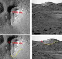
I flipped the HiRise image of Von Braun to compare it with the Pan Cam shot.
Hopefully we will find that the slope up to the edge of the cap is not as bad as it looks in the Pan Cam image.
If Spirit could get to the red "X", the view of the cliff may rival Opportunity's views of Cape Verde.
|
Posted by: Tesheiner Apr 7 2009, 08:04 AM
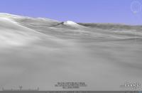
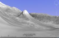
Not so sure.
Here're a few simulated views taken from Google Earth. The first one is from near the current position (see navcam for comparision) while the second and third ones were taken some meters to the south where West Valley opens wide to the open space between HP and VB/G. The third and last simulated view has 3x vertical exageration and I would call this terrain ... "sporty".
|
|
|
|
Posted by: Stu Apr 7 2009, 08:50 AM
Another "cheat colour" pic...
|
Posted by: Ant103 Apr 7 2009, 12:43 PM
Wow, nice "cheat color" version Stu and Astro0
I'm wondering too if they will take a color view of this landscape, it's a nice place.
The navcam pano of the Sol 1869
http://www.astrosurf.com/merimages/Spirit/2009/Sol1869-pano.jpg
And an anaglyph version
http://www.astrosurf.com/merimages/Spirit/2009/Sol1869-pano-ana.jpg
Posted by: jamescanvin Apr 7 2009, 01:26 PM
The PDT says no - driving again tosol (1870)
Posted by: climber Apr 7 2009, 01:35 PM
I agree that it's vey challenging terrain.
First we have to avoid the sandy area in front of us. It seams then to go a bit downslope for a while but, looking at the route map, I think getting to the foot of VB will be challenging. Then, which side to go? West rim seams a better slope to climb than East rim but, as Goddard is on the East...
Now, as we'll get to the narrow part of the West valley soon, I hope we'll get a solar panel clean up there since the "air" has to acclerate a bit to pass this area.
Posted by: mhoward Apr 7 2009, 01:57 PM
http://www.flickr.com/photos/marscat/3421380414/sizes/l/
Spirit sol 1869 view
Posted by: PaulM Apr 7 2009, 05:53 PM
The most likely reason for taking the next color pan will be to give Spirit something to do when it next gets stuck. I would therefore be happiest if no more color pans are taken until Spirit is within MiniTes range of Von Braun.
Posted by: climber Apr 7 2009, 07:17 PM
Following Paolo's remark regarding the available power, does somebody know how much energy's needed to get the full color panorama we're talking about?
Thanks
Posted by: fredk Apr 7 2009, 07:50 PM
Another drive tosol:
http://qt.exploratorium.edu/mars/spirit/navcam/2009-04-07/2N292380548EFFB159P0691R0M1.JPG
And check out the dust devil hiding behind Tsiolkovsky hill to our west:
http://qt.exploratorium.edu/mars/spirit/navcam/2009-04-07/2N292281039EFFB100P0703R0M1.JPG
Posted by: fredk Apr 7 2009, 08:01 PM
Sol 1870 stereo navcam view:
|
Posted by: Tesheiner Apr 7 2009, 08:08 PM
... and the navcam mosaic.
|
Posted by: alan Apr 7 2009, 08:47 PM
Where to next? Dusty patch on the left, lots of rocks in the center, go to the right?
Posted by: ustrax Apr 7 2009, 09:49 PM
Seing Spirit roving brings me to tears...
Posted by: lyford Apr 7 2009, 10:44 PM
At Doug's talk at JPL he made mention of how eagle eyed the UMSF crew were with the comment (I am paraphrasing) "If anything moves on Mars, we'll catch it. - even Spirit." It seems like she was parked for so long, with only incremental changes in location.
It's almost overwhelming to see whole new views from Spirit - I am so glad our rover is living up to its name again.
Posted by: Shaka Apr 8 2009, 01:33 AM
Seriously, Rui, how can you boldly ride like a conquistador, if your eyes are always full of tears?
Posted by: climber Apr 8 2009, 07:38 AM
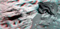
Using anaglyph I can see this one:

|
Posted by: djellison Apr 8 2009, 10:07 AM
It would be a miracle to get to that sort of location given her lack of mountain-goat ability. AND....late evening shadowing on the arrays....eek
Doug
Posted by: climber Apr 8 2009, 11:58 AM
I wonder if trying to climb "spiraling" instead of straith as was done to get back to HP would help.
This will loook a bit like the traverse to get to Larry's lookout: http://www.unmannedspaceflight.com/index.php?showtopic=44&st=86
Now, which way would be the best regarding the RF (and sun illumination,etc...): going clockwise or counter clockwise?
Posted by: djellison Apr 8 2009, 12:48 PM
Larrys Lookout, remember, we had 6 wheel drive - and that was a many-hundreds-of-metres zig zag.
At VB-we're looking at maybe 10-20m to zig-zag. If it were me trying - I'd just about circle the thing, then zig zag the best approach to the northern face.
Posted by: SpaceListener Apr 8 2009, 02:42 PM
The knowing that Spirts has 5 wheels. One is fixed. The best terrain for this kind driving is rolling on surface with least sand and stone since they provide greater friction to roll. Hence, the best driving is going in zigzaging avoiding these obstacles. The surface with least sand and stones will provide to Spirit greater slope angle capability to climb.
Posted by: climber Apr 8 2009, 04:04 PM
We're coming from the North, don't we? So you're talking about a full circle?
Personaly, I'll go for the west ridge: from West to East...
Posted by: Tesheiner Apr 8 2009, 08:00 PM
Few images in the latest batch, but enough to confirm the mobility info from the PDT: today's drive was around 6m towards southeast.
Now, if Mike could post an MMB panorama with a virtual rover on it...
Posted by: mhoward Apr 8 2009, 08:18 PM
Yes; an interesting move. Can't say that I understand it yet, but hey, it's movement.
http://www.flickr.com/photos/marscat/3424946634/sizes/l/
Posted by: fredk Apr 8 2009, 09:44 PM
It seems like a reasonable move to me. We talked before about how it makes sense to hug the side of HP as closely as we can during the drive through West Valley, to maintain as much elevation as possible. It looks like the plan will be to try to cross the smooth sandy patch up ahead at the base of HP. We can't cross sandy terrain that's at too much of an incline, but I'd guess that this patch is pretty close to level.
As for the approach to VB, I'd argue for the same thing: keep to the east as much as possible, so we have as much elevation as we can when we hit VB. In fact, with luck, if the slopes and surfaces are OK, we may be able to drive right up to Goddard (possibly even entering it on its SE side), and then continue switch-back style up VB, getting close to the cap rock:

|
This sketch was based on the orbital anaglyph, trying to keep high and follow not too steep paths. But I have no quantitative idea of what these slopes are like. The operative words in all this are "with luck"!
Posted by: mhoward Apr 8 2009, 10:12 PM
I think you're perhaps right, fredk.
Here's another view of the sol 1871 position, this time as seen from the sol 1869 position.
http://www.flickr.com/photos/marscat/3425182468/sizes/l/
Posted by: ngunn Apr 8 2009, 10:16 PM
I think you've got that exactly right. Von Braun may be inaccessible, but Goddard should be OK (maybe even providing a new 'winter haven' on the drive-on-and-tilt-off principle). The science may be the same at both sites. Anyhow it makes historical sense - Tsiolkovsky, Goddard, von Braun in that order.
Posted by: Astro0 Apr 8 2009, 10:53 PM

|
Certainly this path looks inviting compared to the rocky road on the right.
That's what probably scares me about it.
Tread carefully Spirit!
Posted by: ElkGroveDan Apr 8 2009, 11:07 PM
As one who has hiked, biked and driven on desert terrain, I'd say keep left, or go way to the right among the rocks. If I was in an off-road vehicle in this scene I'd put it to the floor and hit that sandy stretch going into a left turn, wheels spinning, and send that sand flying into the air off to the right, to the hoots and cheers of the people in the vehicle behind me. i.e. it looks soft, and it looks deep.
Posted by: Shaka Apr 9 2009, 12:42 AM
I'm telling the Sierra Club about you, Dan'l! Bashing up our wilderness areas like that.
Back OT, Didn't the MER mappers produce a nice topographic map of the Home Plate area a year or two ago. I don't think it included the Von Braun region, but I could be wrong. How about it, Paolo? Have you drivers got definite numbers to guide our approach?
Posted by: RoverDriver Apr 9 2009, 06:33 AM
Back OT,
Didn't the MER mappers produce a nice topographic map of the Home Plate area a year or two ago. I don't think it included the Von Braun region, but I could be wrong. How about it, Paolo? Have you drivers got definite numbers to guide our approach?We have the NAVCAM panoramas that were captured along the route from the south valley to WH3. We also have the nice DEM from USGS (publicly available) to guide us through. Unfortunately we do not have surface imagery near Goddard and Von Braun. HiRISE is an incredibly useful tool, but Spirit obstacles (small rocks, sand traps etc..) cannot realy be seen from orbit, so we really have to have surface imaging.
The next few drives will be challenging, but there will be more difficult terrain ahead of us.
I was not part of the driving team during this drive but if I can read between the lines (tracks?) I believe they gave priority to maintaining elevation. One thing we have learned: Spirit has quite a bit of difficulty in climbing, so once you lost elevation you will have to pay a high price to get it back.
Regarding spiraling around VB, I don't think that would work. The rover would make progress sure but the side slip would not allow the rover to gain elevation. The slopes around VB are quite steep. But first let's try to get there. Keep your eyes on the road.
Paolo
Posted by: Tesheiner Apr 9 2009, 07:15 AM
So, maybe what we are seeing is an attempt to circumnav the sand patch by the left (east) side, almost touching HP's slope?
> I believe they gave priority to maintaining elevation.
The mobility info from previous drives tells the rover is now around 70-80cm higher than before the move.
Posted by: Geert Apr 9 2009, 11:25 AM
If you look at the very useful projection from Astro0 http://www.unmannedspaceflight.com/index.php?showtopic=44&view=findpost&p=138924 it looks to me like if you continue hugging the site of homeplate (which indeed seems the most logical thing to do) you will end up at a quite nasty sudden rocky patch (hidden from view from the present navcams as it slopes down at bit?) which does not look very good. To avoid it you would need to turn downslope a bit, but the sand over there looks even worse..
It seems almost impossible to get much drive-info from HiRISE, no matter how wonderful its resolution but you need to pancam and navcam images to make sense of what you are looking at.
Posted by: jamescanvin Apr 9 2009, 11:55 AM
It doesn't look that bad to me - and being downhill, it shouldn't be a problem for Spirit to cross IMO.
Posted by: fredk Apr 9 2009, 03:32 PM
I agree the rocky ledge up ahead at the end of the sandy patch doesn't look bad. As James said, it will be downhill for us, as you can see in this anaglyph view from sol 1350:

|
Posted by: climber Apr 9 2009, 04:30 PM
Do you know if this is the altitude difference between start and end of drive or the positive total taking in account ups and downs during the drive (like the odometry)?
Posted by: Tesheiner Apr 9 2009, 05:50 PM
The former.
Posted by: RoverDriver Apr 9 2009, 07:50 PM
If I understand the question correctly, the rover position and attitude are integrated over time. That is, the rover propagates the commanded motion by using the IMU data to determine istantaneously the rover position and attitude. Whenever we use Visual Odometry, this would affect the position only, not the attitude. The IMU is much more accurate than VO.
Paolo
Posted by: Fran Ontanaya Apr 10 2009, 08:47 AM
Von Braun seems to have a quite aerodynamic shape. Maybe the airflow could be modelled to hunt for cleaning events.
Posted by: Tesheiner Apr 10 2009, 10:29 AM
I see a color pancam mosaic (named "Home Plate survey") in the plans for the following sols, meaning that we will spend the Easter stopped here. And speaking about cleaning events, I'm wondering if this stop may be related to an attempt to find some breeze flowing here.
Posted by: BrianL Apr 10 2009, 01:34 PM
Or they just want the Easter long weekend off. Not that there's anything wrong with that.
Posted by: fredk Apr 10 2009, 03:04 PM
Thanks for the info, Tesheiner. So this is another reason to drive close to the side of HP. Let's hope for a spectacular pan...
Posted by: Stu Apr 10 2009, 08:33 PM
Little off-topic, sorry, but this is set at Spirit's current location, and I honestly can't think where else to put it...
http://cumbriansky.wordpress.com/2009/04/10/rover-hugger (fiction)
Posted by: CosmicRocker Apr 11 2009, 01:21 AM
Posted by: Phil Stooke Apr 11 2009, 01:57 AM
...and this is just the navcam. They should try to climb up here and get back on top.
Phil
http://qt.exploratorium.edu/mars/spirit/navcam/2009-04-10/2N292471894EFFB188P1985R0M1.JPG
Posted by: Shaka Apr 11 2009, 04:52 AM
Not possible here, but they should try to get within reach of the lowest in situ strata so we can resume our study of the history of HP.
Posted by: ElkGroveDan Apr 11 2009, 05:59 AM
Just wow! If I came across that scene in the Mojave desert I would go split those layers looking for trilobites.
Posted by: mhoward Apr 11 2009, 01:45 PM
Here's the sol 1871 Navcam anaglyph mosaic (360x90 equirectangular facing south):
http://www.flickr.com/photos/marscat/3430866741/sizes/l/
And I recommend the (headache-inducing but worth it) http://mmb.unmannedspaceflight.com/MERA1871NavcamAnaglyph.mov (1.4 MB).
Adding: and, if you don't have red-blue glasses or can't use them, here's the http://mmb.unmannedspaceflight.com/MERA1871NavcamLeft.mov (1.3 MB)
Posted by: Tesheiner Apr 11 2009, 08:03 PM
I could spend hours looking to this VR mosaics. Looking forward the color pancam ...
Now wait! What's the rover doing in the foreground! Wasn't Spirit supposed to be after the ridge beyond Von Braun?
Posted by: brellis Apr 12 2009, 05:47 AM
Regarding the http://qt.exploratorium.edu/mars/spirit/navcam/2009-04-10/2N292471894EFFB188P1985R0M1.JPG Phil posted:
What process causes the steady vertical scattering of rocks in this pic? It looks like a Ben & Jerry concoction.
Posted by: jamescanvin Apr 13 2009, 03:35 PM
Pioneer Mound in 3D colour:
http://www.nivnac.co.uk/mer/index.php/pioneer_mound
And for those without 3D glasses, a 2D version:
http://www.nivnac.co.uk/mer/index.php/pioneer_mound
(Both thumbnails link to the same blog entry)
James
Posted by: Floyd Apr 13 2009, 10:05 PM
Great image. Must have taken the Zen West Valley Caretaker a long time to rake the sand scallops into alternating north/south and east/west patterns.
Posted by: dburt Apr 14 2009, 03:28 AM
Inasmuch as most of the pieces appear to be layered and thus similar to the rocks cropping out above them on the slope, I would guess the process of gravity. In other words, they might be broken pieces of talus, such as one would find towards the foot any steep outcrop. This would make them different from most of the other random pieces of meltrock and lava distributed across the surface. Most of those other rocks were probably scattered as a direct result of explosive cratering by meteorite impacts.
--HDP Don
Posted by: dburt Apr 14 2009, 03:33 AM
And if I came across it on Mars I couldn't be certain whether I was looking at a scene from Gusev or Meridiani.
In either place, I'd probably go looking for spherules. -- HDP Don
Posted by: Tesheiner Apr 14 2009, 07:32 AM
Moved posts related to the reboots to a new thread here: http://www.unmannedspaceflight.com/index.php?showtopic=5954
Posted by: fredk Apr 16 2009, 03:05 PM
http://marsrovers.jpl.nasa.gov/newsroom/pressreleases/20090415a.html, including a marci image (and a few words about Spirit's reboot problem).
Posted by: Tesheiner Apr 23 2009, 11:09 AM
It's good to post again in this thread.
Spirit is on its sol 1886 and the imaging sequences planned for today are:
01886::p0693::03::6::0::0::6::0::12::navcam_3x1_az_162_3_bpp
01886::p1212::07::2::0::0::2::0::4::front_haz_ultimate_2_bpp_pri15
01886::p1254::00::2::0::0::2::0::4::front_hazcam_fault_pri15_4bpp
01886::p1312::09::2::0::0::2::0::4::ultimate_rear_hazcam_2_bpp_pri15
01886::p1354::01::2::0::0::2::0::4::rear_haz_fault_pri15_4bpp
01886::p1911::09::2::0::0::2::0::4::navcam_1x1_az_270_1_bpp_pri_27
01886::p1921::06::2::0::0::2::0::4::navcam_1x1_az_90_1_bpp_pri_27
01886::p2129::01::4::4::0::0::2::10::pancam_cal_target_L257R2
01886::p2369::19::24::0::0::24::2::50::pancam_6x1_HP_outcrop_L257R2
01886::p2370::19::8::0::0::8::2::18::pancam_4x1_drive_dir_L2R2
01886::p2600::12::2::2::0::0::2::6::pancam_tau
It's a driving sol. Knock on wood!
Posted by: SFJCody Apr 23 2009, 01:53 PM
Well, Opportunity had bad luck... so I'm guessing that means Spirit will get some good luck!
Posted by: Phil Stooke Apr 24 2009, 01:35 AM
There's only so much to go around. I found a $10 bill in a parking lot, Spirit went haywire.
Phil
Posted by: ilbasso Apr 24 2009, 08:00 PM
I think I may have inadvertently stolen the luck from both rovers. A 60-ft tree in my back yard blew down yesterday. It grazed the corner of my house, taking out the gutter and downspout, and the top came to rest less than 3 feet from my neighbor's house. A couple of feet in either direction and there would have been major property damage to one house or the other!
At least Spirit and Opportunity don't need to watch out for falling trees!
Posted by: BrianL Apr 24 2009, 09:38 PM
Well, lucky for them they didn't land near http://mmmgroup.altervista.org/e-trees.html.
Posted by: Poolio Apr 25 2009, 12:33 AM
Well, if no one else is going to mention it...
It was all sunshine and daisies at Gusev today. Spirit http://www.jpl.nasa.gov/news/news.cfm?release=2009-074 today, and she's had a fairly significant http://marsrovers.nasa.gov/mission/status_spiritAll.html#sol1879... 306 whr! The last time she cracked the 300 mark was about the time she escaped Tartarus.
I'm beginning to take that "conservation of luck" thing seriously...
Posted by: alan Apr 25 2009, 12:54 AM
In the stamp posted on the tracking site it looks like a turn in place to face the direction of the next drive.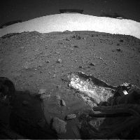
Posted by: Fran Ontanaya Apr 25 2009, 01:46 PM
Just curious. Some of the highest natural radioactive grounds are related to volcanic springs. Is there any way Spirit could tell about the local radiation levels?
Posted by: RoverDriver Apr 25 2009, 08:00 PM
Unfortunately none of the on-board instruments seem to be sensitive enough to measure the radiation levels. We have plenty of components that can be affected, but none that can determine the nature and intensity of the radiation. At least, this is what I was told whn asked about it last week.
Paolo
Posted by: peter59 Apr 25 2009, 08:51 PM
We wait for a series of excellent images.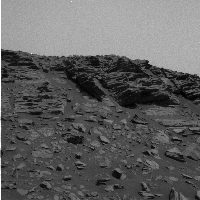
Posted by: alan Apr 26 2009, 02:57 PM
Wait? What is this wait you speak of?
|
|
false color hand stitched from stamps
Posted by: mhoward Apr 26 2009, 03:13 PM
Even in stamp form, that's really something.
Now somebody go kick the server that's jammed, please. (Lightly.)
Posted by: alan Apr 26 2009, 09:59 PM
Even with the move between the mosaics still sort of fit together
|
Posted by: Tesheiner Apr 27 2009, 11:20 AM
Some "stamps" from the latest drive (sol 1889). It looks like the drive ended due to excessive slippage.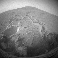
Here are similar shots from the previous site (sol 1886) for comparision.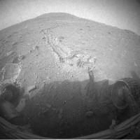
Posted by: BrianL Apr 27 2009, 12:03 PM
We've seen this movie enough times now to know how it ends. Yes, I'm a pessimist, but we get that way for a reason. 
Posted by: djellison Apr 27 2009, 01:27 PM
After a few sols of trying, they will get out of the problem and continue.
It happened at Tartarus, it happened after WH3, it happened on the way to McCool hill, it happened near Larry's Lookout, it happens again and again, it even happened at Purgatory and other places at Meridiani. Yet every time, they've got out.
So yeah - we know how it ends, it ends great. There is no just cause for pessimism.
Posted by: fredk Apr 27 2009, 02:18 PM
Remember that in this part of the West Valley route, we would have to move somewhat uphill if we got closer to HP, and downhill away from HP. It looks to me from those thumbnails like the latest move was somewhat towards HP, so we might expect difficulty. They seem to be attempting to get up onto the smooth, sandy patch up ahead just below HP. Even if they can't do that, there are potential routes farther from HP that wouldn't mean as much (if any) climbing.
Posted by: climber Apr 27 2009, 03:23 PM
...
So yeah - we know how it ends, it ends great. There is no just cause for pessimism.
Posted by: Tesheiner Apr 27 2009, 03:58 PM
This is just a guess, but I think they attempted a move due south not climbing at all. But since Spirit is laterally tilted (roll axis) it means more force is applied to the left side wheels and that could be the reason why we see the LF wheel digging the soil. My 2c.
Posted by: marsophile Apr 27 2009, 05:15 PM
Paolo
I would guess the number of streaks in the camera images might indicate relative changes in the amount of radiation, but not a measure of the absolute intensity if there is nothing to calibrate it to. Perhaps comparing the streak count in Spirit to that of Opportunity might give some rough measure of differences in radiation between the two sites?
Posted by: BrianL Apr 27 2009, 05:43 PM
Just to clarify my earlier message, I didn't mean to give the impression that I thought we were stuck and can't get moving again. What I'm wondering is, is there any traversable path to VB&G? Spirit seems to repeatedly get to a point where the door just gets slammed shut and she has to try a new route. It happened at WH3, and at various points around HP, now it seems to be happening again through the West Valley. Yes, perhaps a jump to the left and a step to the right is all she needs to start moving forward again. Hope so. But if not, route options are becoming scarcer than Martian trees. OK, I'll try to be an optimist but are you sure you want me in the optimist camp? 'Cause I generally get proven wrong.
Posted by: Marz Apr 27 2009, 07:11 PM
Does a cosmic ray leave a different pattern of streak on CCDs than alpha rays? Are alpha rays even able to penetrate the lens/covering to reach the CCD? I always assumed CCD streaks were entirely caused by cosmic rays and therefore their frequency of occurrence would be more a map of solar wind than anything indigenous to Mars?
It would be interesting to scan historical images for streaks and compare them statistically somehow (is exposure time based on the filter used, or is it constant)? Any other data mining ideas from 5+ years of lander data?
Posted by: centsworth_II Apr 27 2009, 07:17 PM
Are cosmic rays even a component of solar wind, or are they strictly from sources outside of the solar system?
Posted by: tty Apr 27 2009, 08:00 PM
At least here on Earth (galactic) cosmic rays are unusually strong just now, since sun activity is exceptionally low. This weakens the solar wind and increases the amount of cosmic radiation that reaches the Earth. I imagine it would have the same effect on Mars, perhaps even more, since it is farther from the Sun.
Posted by: RoverDriver Apr 27 2009, 08:25 PM
That would work, but only as far as the camera is integrating, which could be done during the night, and am not sure we can afford nighttime activity.
Paolo
Posted by: RoverDriver Apr 27 2009, 08:27 PM
I'm not an expert on this topic, but on Mars there is no magnetic field to speak of, therefore the amount of radiation that is received on the surface should be proportional to the radiation above the atmosphere, shouldn't it?
Paolo
Posted by: stevesliva Apr 27 2009, 09:26 PM
Would probably depend on the angle of incidence... in that an alpha won't cause a streak, but a cosmic ray might not cause one either.
Any other unhardened memory element could also conceivably measure the rate of alpha/cosmic ray particles. In semiconductor parlance, it's called SER, for soft error rate. As the RAD-whatever computer is hardened, though, they've done their best to minimize SER. If there is some instrument memory somewhere that's not rad-hard, you could start sampling it. But engineers have generally done their best to avoid memories that would see any SER rate that would be measurably different from one place to another. If the flash isn't especially hardened, and there's a way to monitor errors, that could work, but it is also probably designed NOT to do this.
Posted by: PaulM Apr 28 2009, 11:53 AM
I think that the program flash is most probably "especially hardened".
However this got me thinking about what a rover does if a test of the checksum of its executable image fails during power up? I understand that a rover has two executable images stored in flash. This is to allow a rover to run an old executable image whilst building a new executable image in flash. I presume that if the latest executable image fails its checksum test on power up then the rover runs the older executable image instead?
This made me wonder what would happen if a checksum failure was to occur after 2010? The very latest rover executble image has a fix in it to allow commands from Earth with a date stamp of greater than 31-DEC-2009 to be accepted. What I wondered was, whether a rover running its old executable image after 2009 would still be able to accept commands from Earth?
Does the old executable image need to be patched to accept date stamps of greater than 31-DEC-2009?
Posted by: fredk Apr 28 2009, 01:57 PM
Sol 1888 pancam images up:
http://qt.exploratorium.edu/mars/spirit/pancam/2009-04-28/2P293976979EFFB1AUP2372L7M1.JPG
Posted by: Tesheiner Apr 28 2009, 02:36 PM
Good kick!
Now, to complete the "maintenance work", I wish they fill the gap since 21-Apr. I mean, all pictures downlinked since that time are still missing.
Posted by: mhoward Apr 28 2009, 04:08 PM
Are we sure those pictures were downlinked? I wonder if they could have been lost due to Spirit's issues.
Posted by: Tesheiner Apr 28 2009, 04:37 PM
Actually, the gap starts after the 11-Apr. There's a big bunch of pictures missing.
Posted by: tty Apr 28 2009, 06:31 PM
Yes, and it is this radiation that increases when the solar wind is weak. The solar wind is a plasma (though a thin one) and therefore has a magnetic field that prevents some of the galactic cosmic radiation from penetrating into the inner solar system.
Posted by: fredk Apr 28 2009, 08:12 PM
Looks like the gap has been filled:
http://qt.exploratorium.edu/mars/spirit/pancam/2009-04-28/
Posted by: mhoward Apr 28 2009, 09:15 PM
Hooray! This is about all I have time for for the next month, but:
http://www.flickr.com/photos/marscat/3484457520/sizes/l/
Pancam mosaic; Spirit sols 1886 and 1888.
Posted by: Stu Apr 28 2009, 09:19 PM
Couple'a anaglyphs here...
http://stugallery.wordpress.com/2009/04/28/spirit-stalks-towards-von-braun
Posted by: alan Apr 29 2009, 12:33 AM
mosaic from sol 1886
|
|
Posted by: Zeke4ther Apr 29 2009, 03:18 AM
Beautiful as always!
Posted by: CosmicRocker Apr 29 2009, 04:53 AM
What a sight to behold. Thanks Mike and Alan. We've been waiting a long time for that view. I hope Spirit can get closer to some of those lower beds.
Posted by: Shaka Apr 29 2009, 05:09 AM
OooooooooooWOW! Deeeeeeeep exposures on the far right!
gotta have it, tom.
Posted by: Tesheiner Apr 29 2009, 08:11 AM
Spirit is struggling to move out of this place. Tosol's drive (1891) had the wheels still digging in the soil.
http://nasa.exploratorium.edu/mars/spirit/rear_hazcam/2009-04-28/2R294075825EFFB1BUP1354R0M1.JPG -> http://nasa.exploratorium.edu/mars/spirit/rear_hazcam/2009-04-29/2R294253680EFFB1C6P1312R0M1.JPG
http://nasa.exploratorium.edu/mars/spirit/forward_hazcam/2009-04-28/2F294075759EFFB1BUP1254R0M1.JPG -> http://nasa.exploratorium.edu/mars/spirit/forward_hazcam/2009-04-29/2F294253614EFFB1C6P1212R0M1.JPG

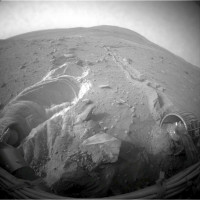


Posted by: climber Apr 29 2009, 08:35 AM
I told you where drive: http://www.unmannedspaceflight.com/index.php?s=&showtopic=5901&view=findpost&p=138875
Seriously, if rear weels are stucked, we have to push RF or rotate around it, right? To rotate, rear weels have to move one direction or the other. Can we do so in this position or do we have a push a bit to get more room?
Posted by: djellison Apr 29 2009, 08:39 AM
Remember - we're driving backwards - so if you wanted to rotate the 'back' around (which is the front) - you've only got one wheel to do it with.
I know what I might try. Just a backward (same direction we're already going) drive of, say, 5m - but with NEITHER front wheel turning. Drag both of them, the bust one, and the working FL wheel. If you look at the trenches they're digging, it might suggest that the FL churning up could be part of the problem. The rear wheels are damn close to some good terrain I think. Just a little pop up there and we're off again
Posted by: Tesheiner Apr 29 2009, 08:47 AM
Here's a navcam mosaic taken after tosol's drive, pointing west and covering the whole area opposite to HP.
|
|
Let's see if Paolo can give us some tidbits.
What I can tell, based on the pointing of the above mosaic and a similar pancam one, is that the focus now seems to be to the west and not due south. In other words, they might attempt driving by the west side of the west valley, avoiding this sand patch by the right.
Posted by: Stu Apr 29 2009, 09:53 AM
Churn... churn... churn...

|
Posted by: fredk Apr 29 2009, 01:42 PM
Thanks for all the images, guys. The recent front hazcams are stunning, aren't they, with that white soil being dug up by the LF wheel? And notice that the stuck RF wheel hasn't exposed any white. Is this because the white soil is too deep for the RF to expose, but the LF has dug down far enough? Or is the white soil localized horizontally?
I'd guess the latter, based on the images, since in the rightmost (in the images) wall of the LF trench, it looks like there is white soil immediately below the surface.
Posted by: Daba Apr 29 2009, 03:24 PM
Hi!
This seems to me like layers in the trench or... could be just dust deposits from the wheel movement. What do you think?
http://nasa.exploratorium.edu/mars/spirit/forward_hazcam/2009-04-29/2F294253614EFFB1C6P1212R0M1.JPG
Posted by: Tesheiner Apr 29 2009, 04:03 PM
First of all let me say that this trench/deposit was not due to the last drive but to the previous one during sol 1889. See here: http://nasa.exploratorium.edu/mars/spirit/forward_hazcam/2009-04-28/2F294075759EFFB1BUP1254R0M1.JPG
Now, back to the question I would say it's due to the wheels movement, actually because that drive (and almost all of them) was not a continuous wheel spin from start to end but stepwise. Spin the wheels, stop, spin again, stop, spin, ...
Posted by: climber Apr 29 2009, 04:52 PM
I don't want to open up another far rim - near rim debate here but it seams to me that we can see a white edge on Goddard on this pancam picture I only can match with a far rim white edge on the the route map picture.
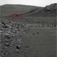
|
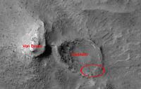
|
...and YES, I'm again a farimer
Posted by: Phil Stooke Apr 29 2009, 05:37 PM
http://marsrovers.jpl.nasa.gov/gallery/all/2/p/1351/2P246299936EFFAVMAP2405L2M1.JPG
That's from Sol 1351, showing this area from a higher viewpoint. We are not looking into Goddard at all, it is the rocky ridge behind the area you circled. The layered outcrop you are looking at is on the northeast side of von Braun.
Phil
Posted by: jamescanvin Apr 29 2009, 06:12 PM
There is still more to come of this, but I couldn't resist. Mmmm Rocks...
http://www.nivnac.co.uk/mer/index.php/a1886
Anaglyph
http://www.nivnac.co.uk/mer/index.php/a1886
(Both image link to the same blog entry)
James
Posted by: Tesheiner Apr 29 2009, 07:41 PM
GREAT news!!! Just found this on Scott's (Maxwell) twitter page: http://twitter.com/marsroverdriver
Spirit's solar panels are the cleanest they've been in 550 sols.
One piece of good news from Spirit: energy's up to 371 W-hr/sol! This is up from less than 250 in January. She's less starved, at least.
Posted by: djellison Apr 29 2009, 08:33 PM
Consider this. This takes the maybe 25 whrs of 'useable' energy above survival - and makes it 6x bigger
Posted by: dburt Apr 29 2009, 08:45 PM
James
Mmmm, very, very nice rocks, despite the talus (loose fallen rock) obscuring most of the lower part of the exposure. Thanks for the great panoramas. Note the somewhat gravelly (lapilli-bearing in geo-jargon) layer visible to the lower right and the low angle cross-bedding present throughout. As for the rest of Home Plate, this layered sequence appears to consist of surge beds deposited by impact cratering or explosive volcanism.
The steeply dipping layered rocks visible on the Von Braun and Goddard structures probably are surge beds too.
--HDP Don
Posted by: stevesliva Apr 29 2009, 09:00 PM
Dude, that's totally scree and not talus.
Posted by: climber Apr 29 2009, 09:32 PM
Spirit's solar panels are the cleanest they've been in 550 sols.
One piece of good news from Spirit: energy's up to 371 W-hr/sol! This is up from less than 250 in January. She's less starved, at least.
Great great news indeed. Both You & I kinda "predict" the cleaning,didn't we?
Could be a coincidence since the season is the most favorable, but I hold with my theory that the place where Spirit stands right now is the best around for a Ventury effect cleaning i.e. atmosphere acceleration between two "narrow" ridges in this case.
Posted by: djellison Apr 29 2009, 09:56 PM
Just being around any sort of complex terrain I think is going to work wonders. Consider the biggest cleaning event of all - that was up near Larrys Lookout. Other BIG cleans were on the opposite side of HP from here.
Posted by: dburt Apr 29 2009, 10:29 PM
Umm. For the uninitiated, definition of "scree" from Glossary of Geology, 5th Ed., p. 580, American Geological Institute: "A term commonly used in Great Britain as a loose equivalent of talus in all of its senses..." So you say tomahto and scree, and I say tomayto and talus. You can learn a lot on this forum.
-- HDP Don
Posted by: stevesliva Apr 29 2009, 10:44 PM
Scree comes up in hiking guides when describing what you're going to be walking on on certain mountain slopes. I've always thought of it as onomatopoeia, which might be why it comes up in that context. Screeeeeeeeeeeeee. It's the sound effect in my mind when I'm watching rocks tumbling away and envisioning myself following. I guess it might also be the noise a stuck rover wheel makes.
Posted by: eoincampbell Apr 30 2009, 04:52 AM
Would any new/alternate driving strategies be considered by virtue of this recent power boost?
In other words, is Von Braun/Goddard THE ultimate goal, as long as Spirit can use it's known potential?
Or, would new directions come with even greater wind cleaning events?
I have been in awe after this latest driving excursion, unbelievable.
Thank you MER A team.
Eoin
Posted by: Stu Apr 30 2009, 05:21 AM
You want scree? We've got scree here in Cumbria...!
http://www.geolsoc.org.uk/gsl/education/rockcycle/page3715.html
Posted by: centsworth_II Apr 30 2009, 05:45 AM
Whatever the power situation, as long as Spirit is still alive Von Braun/Goddard is the next goal. It will be time to overwinter again before that area has been fully explored. If Spirit survives another winter(!!!), then it may be time to look further... two Earth years from now.
Posted by: climber Apr 30 2009, 07:57 AM
I think you're basicaly right. Anyway, Larry's loukout stand at a path, even if wide, and that the best place for wind acceleration. Another place in Earth mountains where wind acceleration is evident is near ridges and, quite often at the very top itself. Do you remember if this occured near Everest's?
A bit OT but, speaking of Everest, I'm following every day Scott Parazinski's attempt right now to "our" Everest ...as well as "The Other Scott" every sol blog.
Powered by Invision Power Board (http://www.invisionboard.com)
© Invision Power Services (http://www.invisionpower.com)