Reprocessing Historical Images, Looking for REALLY big challenges? |

  |
Reprocessing Historical Images, Looking for REALLY big challenges? |
 May 14 2005, 09:42 PM May 14 2005, 09:42 PM
Post
#31
|
|
 Interplanetary Dumpster Diver  Group: Admin Posts: 4404 Joined: 17-February 04 From: Powell, TN Member No.: 33 |
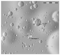
QUOTE (Bjorn Jonsson @ May 12 2005, 10:57 PM) This is extremely impressive, IMHO especially peter59's work with the Mariner 6 & 7 images. I have also been processing some old images, mainly from the Voyagers: http://www.mmedia.is/bjj/images/ I have more that I'll put online someday. I have also scanned all Pioneer 10 & 11 images I could find. Many of these I have not seen online. I will probably add these to my website one day but I would just love to have these in digital form instead of scanned. Modern computers and software can do miracles, what I've seen here is much better than NASA's processing a few decades (!) ago. I also recently downloaded all of the Mariner 10 images and have been playing with them. BTW are the earlier Mariner (4, 6 and 7) imaging datasets not available online - only on CDs ?  I have two projects of my own underway. First, I have some Surveyor 7 stuff that I am scanning that I intend to process. Secondly, I have some digital data for two or three Pioneer images from Saturn (I say two or three because there is one shot that may be a fragment of one of the other two - I need to check carefully). The problem is that it is in paper form, so this will take a lot of work. -------------------- |
 |
 
|
|
May 17 2005, 03:27 AM
Post
#32
|
|
|
Member Group: Members Posts: 123 Joined: 21-February 05 Member No.: 175 |
.
|
|
|
|
|
May 17 2005, 06:29 AM
Post
#33
|
|
 Senior Member Group: Members Posts: 3419 Joined: 9-February 04 From: Minneapolis, MN, USA Member No.: 15 |
QUOTE (GregM @ May 16 2005, 10:27 PM) <snip> I have always felt that Pioneer 10 & 11 never has recieved the attention or accolades that they deserved. The first spacecraft to Jupiter and Saturn for heaven's sakes! Part of the reason for that was that the imaging was very tricky, and never really processed very well compared with what could be done with today's technology. The problem was more that the imagery was crude and nearly an afterthought -- it was crude by the standards of the time in which it was built. The Pioneers were limited in that they were primarily fields-and-particles sensors. The magnetometers, especially, worked a lot better on a spinning spacecraft. And it's really tricky to develop a stationary, pointable scan platform on a spinning spacecraft. The Voyagers managed it, but they're bigger, better spacecraft than the earlier Pioneers. So, since it was just cost- and weight-prohibitive to equip Pioneer with a stationary scan platform, the best they could do to provide imagery was to place a photometer on it and have the Pioneer's own spin scan the photometer through its field of view, one line per rev. The photometer was "nodded" on each scan to get an adjacent line. That kind of imaging is rather inherently crude and low-resolution. It needed an awful lot of correction, because of precession of the spacecraft spin and the distance the spacecraft traveled relative to its target during the time it took to build up a single image. But it was a HECK of a lot better than nothing! -the other Doug -------------------- The trouble ain't that there is too many fools, but that the lightning ain't distributed right. -Mark Twain
|
|
|
|
|
May 17 2005, 01:26 PM
Post
#34
|
|||
|
Solar System Cartographer Group: Members Posts: 10153 Joined: 5-April 05 From: Canada Member No.: 227 |
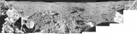
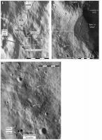
I promised earlier that I would post something from Surveyor 7 - and now I have to as I see Ted is about to trump me! So here are two images from Surveyor 7:
s7a.jpg is a detail, half the original resolution of my full pan but very heavily jpegged to make it small enough to post. s7b.jpg is the full pan, reduced enormously in size. The full pan is about 10,500 pixels wide. These were made by scanning ten prints of mosaic sections, joining them and removing the frame to frame tonal variations and other defects. Incredibly, in some areas it was even possible to correct mosaicking errors in the originals. I have also made true full-resolution pans of a small area by scanning individual frames and mosaicking by hand. I will post something from that another time. Phil
-------------------- ... because the Solar System ain't gonna map itself.
Also to be found posting similar content on https://mastodon.social/@PhilStooke Maps for download (free PD: https://upload.wikimedia.org/wikipedia/comm...Cartography.pdf NOTE: everything created by me which I post on UMSF is considered to be in the public domain (NOT CC, public domain) |
||
|
|
|
||
|
May 17 2005, 03:24 PM
Post
#35
|
|
 Senior Member Group: Members Posts: 2530 Joined: 20-April 05 Member No.: 321 |
QUOTE (GregM @ May 16 2005, 08:27 PM) That's awsome. I have always felt that Pioneer 10 & 11 never has recieved the attention or accolades that they deserved. The first spacecraft to Jupiter and Saturn for heaven's sakes! Part of the reason for that was that the imaging was very tricky, and never really processed very well compared with what could be done with today's technology. Voyager, Galileo, and Cassini came along and suddenly everyone forgot the Pioneers, but there is something very special to being the first. If cameras existed 500 years ago, everyone would be interested in Columbus' landfall images, not nearso Vespucis'. Why should this be any different? Well, Jupiter and Saturn didn't change much between 1972 and 1981, so the subject matter is absolutely fixed in the spacecraft case. You might consider Voyager to be showing you precisely the Pioneer view, only clearer! But that said, Pioneer passed way below Jupiter's orbital plane, which makes those images unique, and Pioneer 11 I remember fondly for the quirk that it returned images of the shady side of Saturn's rings, making the B ring appear dark, and giving the whole shot a feeling of newness quite different than Earth-based photos of Saturn. It made me nostalgic for Pioneer 11 when Cassini returned its first pictures of the shady side of the rings, with that same profile of a bright A, dark B, bright C. |
|
|
|
| Guest_BruceMoomaw_* |
May 17 2005, 06:32 PM
Post
#36
|
|
Guests |
If I remember correctly, Voyager 2 also got some backside shots of Saturn's rings. Nor must we forget that one remarkable close-in shot Pioneer 11 got which, by pure luck, simultaneously revealed the existence of the F Ring and confirmed the existence of a 10th moon of Saturn (since both Janus and what would later be named Epimetheus were only suspected, not confirmed, in the photos taken of Saturn when its rings were edge-on in 1966). As an added stroke of pure chance, Pioneer then flew within only a few thousand km of Epimetheus (I don't know precisely how close) -- close enough for its radiation detectors to clearly sense the wake that the moon was plowing in Saturn's radiation belts. As I recall, it was the timing of this event which enabled them later to determine that it was also Epimetheus, not Janus, that had turned up in the image.
Both moons' existence was confirmed just a few months later by ground-based photos during the planet's next period of edge-on ring views -- which finally cleared up the long-lasting annoying question of Saturn's possible 10th and 11th moons by revealing that Janus' orbit had been miscalculated by Dollfus in 1966 and that it was (to astronomers' amazement) co-orbital with Epimetheus. The same photos revealed another major surprise: Helene, the first Lagrange moon discovered in the Solar System. As for Pioneer's still-unmatched overhead shots of Jupiter's polar regions: the Juno orbiter, if it's selected for New Frontiers, will include a camera for views of Jovian polar weather patterns -- although its PI tells me that it's as much for PR as for real science. |
|
|
|
|
May 17 2005, 07:38 PM
Post
#37
|
|
|
Interplanetary Dumpster Diver Group: Admin Posts: 4404 Joined: 17-February 04 From: Powell, TN Member No.: 33 |
Phil, I am nowhere near trumping you. It will be a month before I have anything to show, and my project is much less ambitious - just to clean up a few frames. As for the Pioneer data, it should be added that the scans were only 6-bit.
-------------------- |
|
|
|
|
May 17 2005, 07:39 PM
Post
#38
|
|
 Senior Member Group: Members Posts: 2488 Joined: 17-April 05 From: Glasgow, Scotland, UK Member No.: 239 |
Phil:
Very, very nice! Now, the $64,000 question (probably easily answered with someone with an eye for sun angles and knowledge of the landing point): Which way are we pointing? And are the rim mountains of Tycho (or any other large crater) visible, or what? -------------------- Remember: Time Flies like the wind - but Fruit Flies like bananas!
|
|
|
|
|
May 17 2005, 07:41 PM
Post
#39
|
|||
|
Senior Member Group: Members Posts: 3419 Joined: 9-February 04 From: Minneapolis, MN, USA Member No.: 15 |
QUOTE (Phil Stooke @ May 17 2005, 08:26 AM) I promised earlier that I would post something from Surveyor 7 - and now I have to as I see Ted is about to trump me! So here are two images from Surveyor 7: s7a.jpg is a detail, half the original resolution of my full pan but very heavily jpegged to make it small enough to post. s7b.jpg is the full pan, reduced enormously in size. The full pan is about 10,500 pixels wide. These were made by scanning ten prints of mosaic sections, joining them and removing the frame to frame tonal variations and other defects. Incredibly, in some areas it was even possible to correct mosaicking errors in the originals. I have also made true full-resolution pans of a small area by scanning individual frames and mosaicking by hand. I will post something from that another time. Phil
Phil, is there anywhere you can post the full-resolution images (even temporarily) where we can link to them? I would *really* like to see them at full resolution... *smile*... -the other Doug -------------------- The trouble ain't that there is too many fools, but that the lightning ain't distributed right. -Mark Twain
|
||
|
|
|
||
|
May 17 2005, 08:01 PM
Post
#40
|
|
|
Senior Member Group: Members Posts: 3419 Joined: 9-February 04 From: Minneapolis, MN, USA Member No.: 15 |
QUOTE (Bob Shaw @ May 17 2005, 02:39 PM) Phil: Very, very nice! Now, the $64,000 question (probably easily answered with someone with an eye for sun angles and knowledge of the landing point): Which way are we pointing? And are the rim mountains of Tycho (or any other large crater) visible, or what? The following comes from my recollection of the supporting text in the NASA publication "Exploring Space with a Camera," where the landing point and orientation of the lander were discussed in detail. The "mountain range" visible at the horizon in Phil's first image *may* be the northeast rim of Tycho. It may also be the ejecta ridges concentric to the rim. Surveyor VII landed about 40 km northeast of the main rim. The topography is *still* poorly-enough understood that it's not clear whether or not the ridges of ejecta would break its line-of-sight to the uplifted rim. But the mountains visible on the horizon are in the right direction to be the actual rim -- if the rim sticks up high enough to be visible from 40 km away. -the other Doug -------------------- The trouble ain't that there is too many fools, but that the lightning ain't distributed right. -Mark Twain
|
|
|
|
|
May 17 2005, 08:05 PM
Post
#41
|
|
|
Solar System Cartographer Group: Members Posts: 10153 Joined: 5-April 05 From: Canada Member No.: 227 |
The detail looks west and north, and the full pan has north roughly at the center and south at each end. The whole area is 30 km north of the rim crest of Tycho, in rolling topography, so you never see too far. Prominent hills north of the spacecraft, seen in these views, extend along a ridge from about 5 km away to 20 km maximum at the north point on the horizon (just a little hilltop among lots of others). So all these hills are on the Tycho ejecta blanket and no discrete large crater rims are visible.
The full size datasets will eventually end up on the Photojournal (current plan). Until then and the publication of my book I will not be making them public. (Though Ted has some!) Phil -------------------- ... because the Solar System ain't gonna map itself.
Also to be found posting similar content on https://mastodon.social/@PhilStooke Maps for download (free PD: https://upload.wikimedia.org/wikipedia/comm...Cartography.pdf NOTE: everything created by me which I post on UMSF is considered to be in the public domain (NOT CC, public domain) |
|
|
|
|
May 17 2005, 09:02 PM
Post
#42
|
|
|
Senior Member Group: Members Posts: 2488 Joined: 17-April 05 From: Glasgow, Scotland, UK Member No.: 239 |
Thanks, guys!
-------------------- Remember: Time Flies like the wind - but Fruit Flies like bananas!
|
|
|
|
|
May 17 2005, 11:27 PM
Post
#43
|
|
|
Interplanetary Dumpster Diver Group: Admin Posts: 4404 Joined: 17-February 04 From: Powell, TN Member No.: 33 |
QUOTE (Phil Stooke @ May 17 2005, 08:05 PM) The detail looks west and north, and the full pan has north roughly at the center and south at each end. The whole area is 30 km north of the rim crest of Tycho, in rolling topography, so you never see too far. Prominent hills north of the spacecraft, seen in these views, extend along a ridge from about 5 km away to 20 km maximum at the north point on the horizon (just a little hilltop among lots of others). So all these hills are on the Tycho ejecta blanket and no discrete large crater rims are visible. The full size datasets will eventually end up on the Photojournal (current plan). Until then and the publication of my book I will not be making them public. (Though Ted has some!) Phil I could share them, but Phil would have to kill me 
-------------------- |
|
|
|
|
May 18 2005, 01:37 PM
Post
#44
|
|||||
|
Solar System Cartographer Group: Members Posts: 10153 Joined: 5-April 05 From: Canada Member No.: 227 |
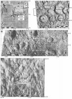
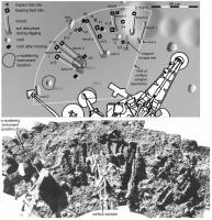
I am attaching a set of maps which portray the Surveyor 7 location all the way from regional scales to the immediate vicinity of the lander. They are considerably reduced in size and quality from the originals to make them postable. This "zooming in" method of portraying a site is what I am doing for every mission.to the Moon... and later Mars.
The Tycho rim is 30 km south of the lander, but the size of boulders on the southern horizon makes it very clear that the horizon in that direction is VERY close... only tens of meters away. There is no chance the rim crest of Tycho is visible. You can't rely on the older reports. Incidentally, similar kinds of arguments show that the position usually mapped as the Luna 9 landing site can't be correct either. I move it at least 20 km NNE of its usual mapped site, on very strong evidence from the surface images themselves. Phil
-------------------- ... because the Solar System ain't gonna map itself.
Also to be found posting similar content on https://mastodon.social/@PhilStooke Maps for download (free PD: https://upload.wikimedia.org/wikipedia/comm...Cartography.pdf NOTE: everything created by me which I post on UMSF is considered to be in the public domain (NOT CC, public domain) |
||||
|
|
|
||||
|
May 18 2005, 02:41 PM
Post
#45
|
|
 Member Group: Members Posts: 255 Joined: 4-January 05 Member No.: 135 |
Very nice, Phil.
Chris |
|
|
|
|

|
Lo-Fi Version | Time is now: 28th April 2024 - 04:02 PM |
|
RULES AND GUIDELINES Please read the Forum Rules and Guidelines before posting. IMAGE COPYRIGHT |
OPINIONS AND MODERATION Opinions expressed on UnmannedSpaceflight.com are those of the individual posters and do not necessarily reflect the opinions of UnmannedSpaceflight.com or The Planetary Society. The all-volunteer UnmannedSpaceflight.com moderation team is wholly independent of The Planetary Society. The Planetary Society has no influence over decisions made by the UnmannedSpaceflight.com moderators. |
SUPPORT THE FORUM Unmannedspaceflight.com is funded by the Planetary Society. Please consider supporting our work and many other projects by donating to the Society or becoming a member. |
|