
Subsurface Voids, CO2, H2O, Dust cycles |

  |
Subsurface Voids, CO2, H2O, Dust cycles |
| Guest_Steve39_* |
 Jul 14 2008, 08:43 PM Jul 14 2008, 08:43 PM
Post
#1
|
|
Guests |
Hello My name is Steve and I had some questions about this image in relation to the current model of current conditions on Mars.
I am new and I understand that some of the greatest minds reside here. I would like to start a discussion on this visible data if possible. To summarize my position of the image, voids created by CO2 sublimation from beneath. The compression and associated gas release produced the movement of surface features visible. This seems reasonable. The layering and current surface ice at the polar cap in spite of seasonal dust deposition, post CO2 sublimation, without another source of H2O seems unreasonable. I would be grateful for any help to reconcile this Thanks in advance, Steve Image from Hortonheardawho 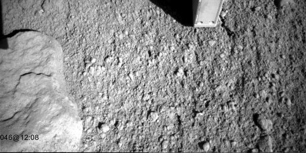 |
 |
 
|
|
Jul 14 2008, 10:29 PM
Post
#2
|
|
|
Member  Group: Members Posts: 233 Joined: 21-April 05 Member No.: 328 |
Steve, I'm not one of UMSF's "greatest minds" -- just a spear carrier -- but I will try responding to your post regarding the apparent deflation of the surface when Phoenix sticks a fork in it (definitely interesting!). And my response to your question is another question: could you elaborate on "the layering and current surface ice at the polar cap in spite of seasonal dust deposition, post CO2 sublimation, without another source of H2O seems unreasonable."?
|
|
|
|
| Guest_Steve39_* |
Jul 14 2008, 10:57 PM
Post
#3
|
|
Guests |
QUOTE (glennwsmith @ Jul 14 2008, 10:29 PM)  Steve, I'm not one of UMSF's "greatest minds" -- just a spear carrier -- but I will try responding to your post regarding the apparent deflation of the surface when Phoenix sticks a fork in it (definitely interesting!). And my response to your question is another question: could you elaborate on "the layering and current surface ice at the polar cap in spite of seasonal dust deposition, post CO2 sublimation, without another source of H2O seems unreasonable."? My point was this image makes sense. We have dust deposition on top of sublimating water ice and CO2 ice. Layers have been seen in the trench that would show periods of more or less ice or dust. At the end of the day we should have dust on top and we do. The satellite images show a bright white ice pack on the northern cap post CO2 sublimation. This would mean that in the summer the ice would be exposed to global dust storms and deposition. Without replenishment of atmospheric water vapor another layer could not form as equilibrium would be reached and past. Atmospheric dust would prevail. In other words the caps should be covered in dust as a result of atmospheric drying process. Respectfully, Steve39 |
|
|
|
|
Jul 15 2008, 05:56 AM
Post
#4
|
|
 Senior Member Group: Members Posts: 2228 Joined: 1-December 04 From: Marble Falls, Texas, USA Member No.: 116 |
I'm not a member of the "greatest minds" club, either, but I'll take a shot at describing what we see here. That surface movement is an excellent observation, but I am not certain it tells us a lot about Martian climate or weather, or history. It seems to me that at the poles we see evidence of the dynamic interplay of large dust storms and winter ice deposition. You might expect that interplay to create alternating layers of dust, sand and various ices.
You would expect to find more ices closer to the actual poles, and more dust and other rock particles as you move away from the poles. That would seem to explain the satellite observations of these interestingly layered poles. QUOTE The satellite images show a bright white ice pack on the northern cap post CO2 sublimation. But wasn't it also bright white prior to sublimation?We have seen quite a few images from machines we have sent to Mars, and which have disturbed the surface there. If I had to hazard a guess regarding the soil movement we see here, I would suggest that the tool simply broke a very weakly salt-cemented surface crust as it pressed downwardly on it. It is not so much a "subsurface void" as it is soil porosity, but that kind of gets into semantics.  -------------------- ...Tom
I'm not a Space Fan, I'm a Space Exploration Enthusiast. |
|
|
|
| Guest_Steve39_* |
Jul 15 2008, 10:42 AM
Post
#5
|
|
Guests |
Thanks for responding Gentlemen,
QUOTE But wasn't it also bright white prior to sublimation? If you cut off the deposition of new water ice then the top layer would be exposed to the atmospheric dust year after year and a dust layer would be started. It would appear the Northern Polar region has a history of this. This would mean alternating periods of water Ice and dust deposition for a long history on Mars. I guess what started my mind going was the Phoenix team stated the depth in the surface material that water ice would be stable. This means that the dust layer at the poles could cut off sublimation. If that is the case then a new source of water vapor would be needed for the next water ice layer. The porosity as you stated may be more common on Mars polar regions due to various ices being involved. QUOTE I would suggest that the tool simply broke a very weakly salt-cemented surface crust as it pressed downwardly on it. A crust for sure. Good observation. Steve39 |
|
|
|
| Guest_Steve39_* |
Jul 16 2008, 03:44 PM
Post
#6
|
|
Guests |
Gentlemen,
May I elaborate. This image shows obvious layers in the polar cap. I am trying to reconcile this image with the image from the Phoenix site for greater understanding of the current process on Mars. I think it would be reasonable to say that this process has been going on for a long-long time. There must be a change in conditions between new ice deposition Now I will propose a few hypotheses out for further discussion. A. It got warmer and dryer with new dust deposition. The problem with this is if the depth of water ice stability at the Phoenix site is just a few cms then the source of water vapor from the poles would be cut off. For these layers to be visible from this altitude with such compression then a depth of at least a few cms would be reasonable. This would mean that a new water vapor source would be needed for the next layer. B. It got colder and dryer. This opens up the door for CO2 to be a primary or secondary constituent in the separation layer. This would explain the eruption sites along the edge of the scarp and potential catalyst for avalanche activity. We know that water under extreme pressure can become ice at temperature well above 0C. I have researched and found no such data for CO2. I would think that it would behave the same. In such a scenario the sublimation process at the polar region would be cut off and a new water vapor source would be needed. I propose the following theory based on surface data from the Phoenix site. Rover sites and MRO imagery. The current Hydro-cycle on Mars is a collaboration of polar sublimation and subsurface eruptions of both liquid and gas emission on both a mega and micro-scale. The satellite data shows areas of floods and water erosion to numerous to mention. I believe there could be a correlation between extreme warm and cold periods that would need a mega-scale eruption to start the next phase of the hydro-cycle. The images from the rover sites could be explained by fines being expelled by subsurface gas that could also be the source of planetary water vapor in the northern hemisphere of Mars. If you request I will post some of these images. Fines in a dry environment can display fluvial characteristics and be confused with liquid. I would like to say Thank you in advance for allowing me to share my thoughts on this controversial subject of the Mars hydro-cycle. At this time I will stand down and allow you guys to discuss freely these theories. I will not take offence and will take each response on its merits and ideology. I believe the unmanned probes to be a data source that should allow us to have a greater understanding of the Universe. Respectfully, Steve39 
|
|
|
|
|
Jul 16 2008, 04:05 PM
Post
#7
|
|
|
Founder Group: Chairman Posts: 14431 Joined: 8-February 04 Member No.: 1 |
QUOTE (Steve39 @ Jul 16 2008, 04:44 PM) The images from the rover sites could be explained by fines being expelled by subsurface gas that could also be the source of planetary water vapor in the northern hemisphere of Mars. Could you go into more detail here - we have two quite different landing sites with Meridiani and Gusev. Very different materials structured in rather different ways. Conretions, layering, cross bedding, sulphates, vugs and so on. How does what you propose, explain those features. Doug |
|
|
|
|
Jul 16 2008, 04:11 PM
Post
#8
|
|
 Senior Member Group: Members Posts: 3419 Joined: 9-February 04 From: Minneapolis, MN, USA Member No.: 15 |
Well, Steve -- not that I doubt the presence of frozen volatiles under the footpads at the Phoenix site (obviously!), but I don't see any landform indications of what has been designated "layered polar terrain" at the landing site.
There is no doubt that water and other volatiles are trapped in the ground at the latitude where Phoenix sits, but I don't see any evidence thus far that this latitude sees the ongoing, annual, dynamic deposition of layering that is seen closer to the poles, where the image you posted is from. Layering may well have happened here long ago, at times when the various ices were deposited here more robustly, but for right now, I'm thinking that we're not actually laying down new layers of ice and soil every year at this site. My take on the cycle seen at this latitude is that a seasonal layer of CO2 ice is laid down every year, which completely sublimates every spring. Whatever thin veneer of water ice that may exist in mid-spring after the CO2 ice goes away simply sublimates away, itself, as summer approaches. It's then carried in the air down to the other pole, where it's laid down in similar transient veneers near the south pole. As seasons change, that water makes a grand traverse from one pole to the other, with the maximum amount of water "in transit," carried in the Martian atmosphere, at equinox. I just don't see landform indications that annual deposition of new permanent layering is actually happening at the Phoenix site. Further north, yes... but not here. -the other Doug -------------------- The trouble ain't that there is too many fools, but that the lightning ain't distributed right. -Mark Twain
|
|
|
|
| Guest_Steve39_* |
Jul 16 2008, 04:31 PM
Post
#9
|
|
Guests |
QUOTE (djellison @ Jul 16 2008, 04:05 PM) Could you go into more detail here - we have two quite different landing sites with Meridiani and Gusev. Very different materials structured in rather different ways. Conretions, layering, cross bedding, sulphates, vugs and so on. How does what you propose, explain those features. Doug Doug, It is indeed an honor to talk with you. The Opportunity site has shown areas of obvious gas emission and some may interpret as liquid flows, Image 1. . This image is from a few sols ago as we approach the cliff face. I will post the vent and context image, image 2. Image 1 is from raw data feed. Image 2 from hortonheardawho. Again this is a water vapor source IMO in relation to the current Mars hydro-cycle, geology not withstanding. Respectfully, Steve39 Image 1  Image 2 
|
|
|
|
|
Jul 16 2008, 04:40 PM
Post
#10
|
|
|
Senior Member Group: Members Posts: 3419 Joined: 9-February 04 From: Minneapolis, MN, USA Member No.: 15 |
Ummm... no. The images you're looking at in Meridiani show a *very* slow flow of fines along the sloped lower wall of Victoria.
The Martian hydrological cycle has been well characterized from orbit. It does not include jets of water vapor coming out of cracks in near-equatorial surfaces. Remember, there are a lot of dry flow features on Mars. Don't mistake every little flow feature as an indication of flowing water or gasses. -the other Doug -------------------- The trouble ain't that there is too many fools, but that the lightning ain't distributed right. -Mark Twain
|
|
|
|
| Guest_Steve39_* |
Jul 16 2008, 04:55 PM
Post
#11
|
|
Guests |
QUOTE (dvandorn @ Jul 16 2008, 04:40 PM) Ummm... no. The images you're looking at in Meridiani show a *very* slow flow of fines along the sloped lower wall of Victoria. The Martian hydrological cycle has been well characterized from orbit. It does not include jets of water vapor coming out of cracks in near-equatorial surfaces. Remember, there are a lot of dry flow features on Mars. Don't mistake every little flow feature as an indication of flowing water or gasses. -the other Doug The other Doug, I have been studying Mars for a while and there are numerous vents in the equatorial region IMO. This is another and I have several more. The bottom line is we need a moisture source if and when the polar ice cap is cut off. I am just trying to reconcile the visible data. You may be correct in your interpretation, but these features exist. We have layers at the cap so we have changes in environmental influence so say the satellite images. Respectfully, Steve39 
|
|
|
|
|
Jul 16 2008, 05:22 PM
Post
#12
|
|
|
Founder Group: Chairman Posts: 14431 Joined: 8-February 04 Member No.: 1 |
I'm afraid the line you're taking is bordering on pseudoscience. I would suggest that other fora are probably better suited to the discussion you're after. |
|
|
|
|

|
Lo-Fi Version | Time is now: 19th April 2024 - 10:44 AM |
|
RULES AND GUIDELINES Please read the Forum Rules and Guidelines before posting. IMAGE COPYRIGHT |
OPINIONS AND MODERATION Opinions expressed on UnmannedSpaceflight.com are those of the individual posters and do not necessarily reflect the opinions of UnmannedSpaceflight.com or The Planetary Society. The all-volunteer UnmannedSpaceflight.com moderation team is wholly independent of The Planetary Society. The Planetary Society has no influence over decisions made by the UnmannedSpaceflight.com moderators. |
SUPPORT THE FORUM Unmannedspaceflight.com is funded by the Planetary Society. Please consider supporting our work and many other projects by donating to the Society or becoming a member. |
|


