Opportunity Route Map |

  |
Opportunity Route Map |
 Oct 21 2005, 01:43 AM Oct 21 2005, 01:43 AM
Post
#811
|
|
 Senior Member  Group: Moderator Posts: 3431 Joined: 11-August 04 From: USA Member No.: 98 |
QUOTE (dilo @ Oct 20 2005, 11:07 PM) I'm absolutely not sure about Sol618 location (very few features visible), so any suggestion/help is welcome!  I think she went north from point n. Slightly west but basically north. If you look I think there's some duplicate bedrock features between the west end of your map and the edge of the bedrock north from n, if that makes sense. |
 |
 
|
|
Oct 21 2005, 02:47 AM
Post
#812
|
|
|
Solar System Cartographer Group: Members Posts: 10153 Joined: 5-April 05 From: Canada Member No.: 227 |
mhoward is right. The small roughly triangular area of rock just above 'o' is also shown at the upper left corner of the mosaic section above 'n'. If the newest section of the mosaic is shifted to the northeast it will be corrected.
Phil -------------------- ... because the Solar System ain't gonna map itself.
Also to be found posting similar content on https://mastodon.social/@PhilStooke Maps for download (free PD: https://upload.wikimedia.org/wikipedia/comm...Cartography.pdf NOTE: everything created by me which I post on UMSF is considered to be in the public domain (NOT CC, public domain) |
|
|
|
|
Oct 21 2005, 02:51 AM
Post
#813
|
|
|
Senior Member Group: Members Posts: 1636 Joined: 9-May 05 From: Lima, Peru Member No.: 385 |
Dilo, your last mapping position of Oppy is correct. I have checked navcam from Oct 20, 2005. Now she is heading toward south according to the forward hazcam (bottom of pictures looks the big ripples) and rear hazcam (the bedrock ends).
Rodolfo |
|
|
|
|
Oct 21 2005, 03:50 AM
Post
#814
|
|
|
Senior Member Group: Members Posts: 2998 Joined: 30-October 04 Member No.: 105 |
This is my projected route map for Oppy over the next few Sols. The dotted Blue line was the first guesstimate of the probable path from a month back, the dotted Red line is the confirmed path (usually per Dilo) and the dashed Blue line is my current guess on Oppy's route for the next couple of Sols.
I think she will go to the south end of the FourLane outcrop and examine the different bedrock exposure there and then head north and west around the dune area. --Bill -------------------- |
|
|
|
|
Oct 21 2005, 09:39 AM
Post
#815
|
||
|
Senior Member Group: Moderator Posts: 4279 Joined: 19-April 05 From: .br at .es Member No.: 253 |
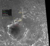
Dilo,
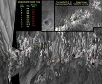
About sol 618, here below is your route map with some annotations (in green) following mhoward and Phil Stooke comments. You will also find another annotation regarding sol 616 position for which I already made a previous comment; it's lost somewhere among all yesterday posts.
Edited: That previous post is here. |
|
|
|
|
|
|
Oct 22 2005, 09:27 AM
Post
#816
|
|
 Senior Member Group: Members Posts: 2492 Joined: 15-January 05 From: center Italy Member No.: 150 |
Thanks for your helping efforts! I will implement all corrections in my next map.
Now I'm preparing images from Sol618/619, to be stitched, reprojected and joined... is a slow/delicate job, while now Oppy is sending 2 panoramas each Sol! So have a little patience, pls. 
-------------------- I always think before posting! - Marco -
|
|
|
|
|
Oct 23 2005, 06:00 AM
Post
#817
|
||
|
Senior Member Group: Members Posts: 2492 Joined: 15-January 05 From: center Italy Member No.: 150 |
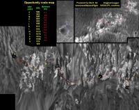
Now map seems ok, but... where the hell is going Oppy?!?
Can someone explain to MER people that Erebus is to South? Very strange strategy  , can someone explain it? , can someone explain it?
Attached thumbnail(s)
-------------------- I always think before posting! - Marco -
|
|
|
|
|
|
|
Oct 23 2005, 08:46 AM
Post
#818
|
|
|
Senior Member Group: Members Posts: 2998 Joined: 30-October 04 Member No.: 105 |
Dilo, Oppy is following a projected path closely. Attached is my "guesstimated" route and as can be seen, Oppy is traveling northward and around that dune complex. This is going to be a difficult part of the journey since she will have to thread a path between a dozen purgatory traps.
I've added an image taken a couple of Sols ago that is looking northwestward and shows the projected path around a low dunefield north of the big dunefield (edit). --Bill -------------------- |
|
|
|
|
Oct 23 2005, 04:57 PM
Post
#819
|
|
|
Senior Member Group: Members Posts: 1636 Joined: 9-May 05 From: Lima, Peru Member No.: 385 |
The change of strategy of route is probably to avoid the big ripples. I seems like that the Oppy will circumven these big ripples following around the projected blue lines from Harris's picture.
It seems like that the Oppy drivers has no exprience of dunes' driving and hence his driving style is of risk avoidance. On the contrary, the Spirit's rover driver looks like they have mountain hiking's experience so their driving style is realist to MER capabilities. I think we have missed lots of opportunities to learn more science terms around the Erebus' northen rims. I have no idea about the exact position of Mogollon rim where Squyers has told in his boletin at Athenea Web page. It looks to be at the southern most rim of Erebus crater?  Rodolfo |
|
|
|
|
Oct 23 2005, 07:22 PM
Post
#820
|
|||
|
Senior Member Group: Members Posts: 2492 Joined: 15-January 05 From: center Italy Member No.: 150 |
Thanks Bill/RNeuhaus, now strategy appear more understable to me...
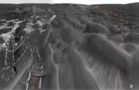
In fact, looking carefully to Sol619 panorama, there are some higher ripples toward Erebus, evident if we make a vertical exageration (5x, horizontal angle is about 145deg).
I traced probable path in order to avoid them but, from the very last images (Sol621) I have impression that there was some further drive toward Nord... This is an updated "bird's eye" view of Erebus/Victoria complex, containing the updated route map.
-------------------- I always think before posting! - Marco -
|
||
|
|
|
||
|
Oct 23 2005, 07:41 PM
Post
#821
|
|
|
Senior Member Group: Members Posts: 2998 Joined: 30-October 04 Member No.: 105 |
Rodolfo--
The Mogollon Rim features are named after geological/geomorphological features in the USA state of Arizona. The outcrop "Payson" is named after a town there. It's pronounced "mow-gee-yon", Spanish pronunciation of an American Indian word. The Mogollon Rim is on the west-southwest rim of Erebus. An annotated MOC image is attached. I think that the Oppy drivers are being cautious since the sand in these ripples can become treacherous with no warning of bad conditions. Dilo-- Great use of that ziggy-zag navcam image. Shows where we were and where we're going. --Bill -------------------- |
|
|
|
|
Oct 23 2005, 08:00 PM
Post
#822
|
|
 Member Group: Members Posts: 531 Joined: 24-August 05 Member No.: 471 |
QUOTE (RNeuhaus @ Oct 23 2005, 06:57 PM) I have no idea about the exact position of Mogollon rim where Squyers has told in his boletin at Athenea Web page. It looks to be at the southern most rim of Erebus crater? Labelled southern Erebus rim: Rodolfo  High Resolution: http://xs48.xs.to/pics/05395/Sol_592_Oppor...90_Labelled.jpg (478 KB) -------------------- - blue_scape / Nico -
|
|
|
|
| Guest_Sunspot_* |
Oct 24 2005, 12:08 PM
Post
#823
|
|
Guests |
Whoah..... you can really see how far north they've gone int he latest navcam images.
http://marsrovers.jpl.nasa.gov/gallery/all...RP1655R0M1.HTML |
|
|
|
|
Oct 24 2005, 01:12 PM
Post
#824
|
||
|
Senior Member Group: Moderator Posts: 4279 Joined: 19-April 05 From: .br at .es Member No.: 253 |
Yes, and based on last pancams I think Oppy will go N (probably NW) even more.
Dilo, I fear that it will be quite difficult to match the vertical projections together without the reference of the outcrops. What do you think? Until Oppy don't reach the next patch of rock, I will try to pinpoint the rover position based on the headings to that little crater looking west. Here below is a first trial based on sol 621 data (the base image is the same I used some weeks ago when talking about possible paths to Mogollon).
The headings can be obtained from pancam images 1P183318548EFF63IRP2406L2M1 and 1P183318548EFF63IRP2406R2M1. That shot was taken with the camera pointed exactly at -90º (info from pancam tracking web) so the headings to the crater rim are: 90 + 2.01º and 90 - 3.07º. Rover positions using this method may have significant errors, but at least they are not cummulative. Edited: Simply disregard this post. I've just downloaded the missing navcam images for sol 621, and a quick parallax measurement places that drive on the 15m range -- a half of what I calculated with the headings to the crater. |
|
|
|
|
|
|
Oct 24 2005, 02:00 PM
Post
#825
|
|
|
Senior Member Group: Members Posts: 1636 Joined: 9-May 05 From: Lima, Peru Member No.: 385 |
Thanks to Bill ad SigurRosfan About Mogollon, Payson and Vermillion ubications. Now, the Oppy is heading with a new objective: "reach as fast and safe as possible to Mogollon" This mean JPL gugs are no longer interested to visit any other thing on the way to Mogollon's rim.
According to the previous Erebus's picture, I see that the northern-west sides there are less vertical (North-South) shadow lines. This mean that the land has ripples less pronounced height so that zone would be flatter to traverse before heading to south that would be rather easy travesing by following between valleys that run from North - South. Rodolfo |
|
|
|
|

|
Lo-Fi Version | Time is now: 30th April 2024 - 07:11 PM |
|
RULES AND GUIDELINES Please read the Forum Rules and Guidelines before posting. IMAGE COPYRIGHT |
OPINIONS AND MODERATION Opinions expressed on UnmannedSpaceflight.com are those of the individual posters and do not necessarily reflect the opinions of UnmannedSpaceflight.com or The Planetary Society. The all-volunteer UnmannedSpaceflight.com moderation team is wholly independent of The Planetary Society. The Planetary Society has no influence over decisions made by the UnmannedSpaceflight.com moderators. |
SUPPORT THE FORUM Unmannedspaceflight.com is funded by the Planetary Society. Please consider supporting our work and many other projects by donating to the Society or becoming a member. |
|