Google Lunar X Prize |

  |
Google Lunar X Prize |
 Jun 18 2008, 03:40 PM Jun 18 2008, 03:40 PM
Post
#91
|
|
 The Poet Dude  Group: Moderator Posts: 5551 Joined: 15-March 04 From: Kendal, Cumbria, UK Member No.: 60 |
Thanks for that, Astroblogger, really appreciate your feedback on this very important issue. Good to know that you're aware of the concerns many people have, and are open to input from them.

-------------------- |
 |
 
|
|
Jun 18 2008, 08:13 PM
Post
#92
|
|
 Dublin Correspondent Group: Admin Posts: 1799 Joined: 28-March 05 From: Celbridge, Ireland Member No.: 220 |
One of our favourite PI's gets involved in the Google Lunar X-Prize - Alan Stern to join The Odyssey Moon project in a part time consulting role.
|
|
|
|
|
Jun 19 2008, 01:10 AM
Post
#93
|
|
|
Solar System Cartographer Group: Members Posts: 10145 Joined: 5-April 05 From: Canada Member No.: 227 |
Thanks for this, Astroblogger. This is a very flat site, and I would see few problems with approaches from either the east or the west. A landing west of the LM would not be far from a secondary crater cluster called Cat's Paw - its rim was visible as a low hill on the horizon in Apollo 11 panoramas. That would make a nice target as well, climbing the gentle slopes of the crater rim to enjoy the views from the top, including a look back at Tranquillity Base in the distance. And Surveyor 5 isn't far away, though its position is a little uncertain.
Phil -------------------- ... because the Solar System ain't gonna map itself.
Also to be found posting similar content on https://mastodon.social/@PhilStooke NOTE: everything created by me which I post on UMSF is considered to be in the public domain (NOT CC, public domain) |
|
|
|
|
Jun 19 2008, 04:43 AM
Post
#94
|
|
 Senior Member Group: Members Posts: 3419 Joined: 9-February 04 From: Minneapolis, MN, USA Member No.: 15 |
The only thing we need to be reasonably careful of, landing close to Tranquility Base, is to make *certain* that even if your targeting is a bit off, you don't run the risk of blasting the historic area with rocket exhaust or pelting it with dust blown by said exhaust.
From the various sources that came out of Apollo, I'd have to think that we can model the closest safe distances from the historic site that you can allow overflights (at various altitudes) and landings. -the other Doug -------------------- The trouble ain't that there is too many fools, but that the lightning ain't distributed right. -Mark Twain
|
|
|
|
|
Jun 20 2008, 03:17 AM
Post
#95
|
||
|
Member Group: Members Posts: 808 Joined: 10-October 06 From: Maynard Mass USA Member No.: 1241 |
Here is a map of the Apollo 11 site superimposed on a baseball diamond
<credit to Bruce Wyman of the Denver Art Museum and NASA>
Cheers -------------------- CLA CLL
|
|
|
|
|
|
|
Jul 8 2008, 08:53 PM
Post
#96
|
||
|
Solar System Cartographer Group: Members Posts: 10145 Joined: 5-April 05 From: Canada Member No.: 227 |
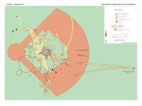
Using some ideas already discussed here - including an idea from nprev - I have put together this poster (grossly reduced to fit on here) for the NASA Lunar Science Conference at Ames in two weeks.
Phil Edit: I have updated the poster. And fixed the attachment problem...
-------------------- ... because the Solar System ain't gonna map itself.
Also to be found posting similar content on https://mastodon.social/@PhilStooke NOTE: everything created by me which I post on UMSF is considered to be in the public domain (NOT CC, public domain) |
|
|
|
|
|
|
Jul 8 2008, 09:22 PM
Post
#97
|
|
|
Merciless Robot Group: Admin Posts: 8783 Joined: 8-December 05 From: Los Angeles Member No.: 602 |
Looks great, Phil!
Very honored by your acknowledgement; thanks, happy to help!
-------------------- A few will take this knowledge and use this power of a dream realized as a force for change, an impetus for further discovery to make less ancient dreams real.
|
|
|
|
|
Jul 9 2008, 05:58 AM
Post
#98
|
|
|
Senior Member Group: Members Posts: 3419 Joined: 9-February 04 From: Minneapolis, MN, USA Member No.: 15 |
Very nice, Phil!
Just one caution (and I know, this is so obtuse it's beyond belief) -- your southwest "safe" landing zone at the Descartes site, located just west of Survey Ridge and just north of Wreck and Stubby, was reported by Young and Duke to be a pretty deep depression in the local lurrain. While the sides of this old depression are shallower than the sides of the larger craters in the area, the topo maps are a little misleading. Survey Ridge (just west of the return leg of the EVA-2 plot) was a very steep slope on its east side, and at the one point where the crew could look over to the other side (south of the beginning of the ridge), they estimated the western side of the ridge dipped down quite a bit further than the east side they traversed. This general impression is also borne out by the pans taken from up the side of Stone Mountain. Unfortunately, their plan to climb to the top of the ridge and head back north along it had to be scrapped when they discovered the power to the rover's rear wheels was off. With only the front wheels powered, the rover was actually unable to climb the east side of the ridge, even angled north along it. Tells you just how steep that ridge actually was. (Good thing that, at their next stop, the crew found the power problem to the rear wheels was due to a circuit breaker misconfiguration...) -the other Doug -------------------- The trouble ain't that there is too many fools, but that the lightning ain't distributed right. -Mark Twain
|
|
|
|
|
Jul 9 2008, 09:01 AM
Post
#99
|
|
 Member Group: Members Posts: 593 Joined: 20-April 05 Member No.: 279 |
Good stuff, Phil. However, I have an issue with the preservation of tracks and footprints.
In the UK we have organisations such as English Heritage and Historic Scotland to protect historical sites from the blatant effects of vandalism and trophy-hunting, and to (gently) control access by members of the public in order to preserve the sites as much as possible for posterity. Preservation for posterity naturally implies "future visitors"...yet a trip to Stonehenge or Skara Brae is many magnitudes easier for anyone on the planet than a trip to the lunar surface, and it's likely to stay that way for generations: possibly to a time when footprints and tracks are considerably degraded. I'm all for the preservation of the material artifacts - they're in an environment which should allow them considerably more longevity than most Earth-based equivalents - but I'd personally draw the line at staying clear of tracks. We know, for example, that there's no "first footprint" we can gaze at in awe in some future decade: it was trampled by Aldrin just a few minutes later, and all subsequent prints near the LM presumably (largely) blasted away during lift-off. Why not treat these sites just like normal, historical, "built sites" on Earth: take care of the artifacts, look but don't touch, only take photos, only leave (new) footprints..? Andy |
|
|
|
|
Jul 9 2008, 11:14 AM
Post
#100
|
|
|
Solar System Cartographer Group: Members Posts: 10145 Joined: 5-April 05 From: Canada Member No.: 227 |
I don't suggest tracks or footprints should be inviolable for all time, only that they should be avoided if possible and until the regulatory regime is defined. In other words, keep GLXP rovers off the tracks for now. I just edited the poster and replaced the file.
Phil -------------------- ... because the Solar System ain't gonna map itself.
Also to be found posting similar content on https://mastodon.social/@PhilStooke NOTE: everything created by me which I post on UMSF is considered to be in the public domain (NOT CC, public domain) |
|
|
|
|
Sep 8 2008, 09:11 PM
Post
#101
|
||
|
Solar System Cartographer Group: Members Posts: 10145 Joined: 5-April 05 From: Canada Member No.: 227 |
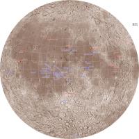
I posted a map earlier showing previous landing or impact sites, and then a GLXP site proposal map.
Now I'm adding a map showing all known landing or impact sites on the nearside. It's off topic a bit (though GLXP teams interested in the heritage prize might like it) but I thought people might like to see it. A few are VERY uncertain, especially the Luna 2 upper stage and Lunar Orbiter 4. Phil
-------------------- ... because the Solar System ain't gonna map itself.
Also to be found posting similar content on https://mastodon.social/@PhilStooke NOTE: everything created by me which I post on UMSF is considered to be in the public domain (NOT CC, public domain) |
|
|
|
|
|
|
Sep 9 2008, 01:39 AM
Post
#102
|
|
 Member Group: Members Posts: 753 Joined: 23-October 04 From: Greensboro, NC USA Member No.: 103 |
Great map, Phil, thanks for posting! I had not seen anything that had all of the impact sites shown. I thought it was especially interesting to see how clustered the S-IVB impacts were. I did not know that they all hit in essentially the same general area, which I find intriguing since the launches from Earth were at different phases of the moon.
-------------------- Jonathan Ward
Manning the LCC at http://www.apollolaunchcontrol.com |
|
|
|
|
Sep 9 2008, 10:50 AM
Post
#103
|
|
|
Solar System Cartographer Group: Members Posts: 10145 Joined: 5-April 05 From: Canada Member No.: 227 |
I did this partly because I don't know of any other map that shows everything.
The background is a composite of USGS relief and Clementine albedo. later, I'll get around to adding other text, grid labels and so on. Phil -------------------- ... because the Solar System ain't gonna map itself.
Also to be found posting similar content on https://mastodon.social/@PhilStooke NOTE: everything created by me which I post on UMSF is considered to be in the public domain (NOT CC, public domain) |
|
|
|
|
Sep 9 2008, 10:51 AM
Post
#104
|
|
 Senior Member Group: Members Posts: 3648 Joined: 1-October 05 From: Croatia Member No.: 523 |
That's a keeper, Phil!
*looks around for a high quality printer* -------------------- |
|
|
|
|
Sep 9 2008, 04:41 PM
Post
#105
|
||
|
Solar System Cartographer Group: Members Posts: 10145 Joined: 5-April 05 From: Canada Member No.: 227 |
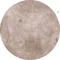
This is the farside map. Of course, these are very heavily compressed to fit here. The originals are 4000 by 4000 pixels.
I have done this because we are going to get a lot of new points soon. In the next year there should be 4 new impacts (Chandrayaan's MIP, Kaguya's Rstar subsatellite, LCROSS (2 events but one point on the map) and Kaguya itself about 6 months after its primary mision ends. Kaguya's Vstar satellite will remain in orbit for about a decade. After that there will be various other end of mission impacts, the ILN landers, and Chandrayaan 2, Selene 2, Chang-e 2 etc., and whatever comes from the GLXP (link to thread topic slipped in at the last minute!) Please point out any omissions or (shudder) errors. Phil
-------------------- ... because the Solar System ain't gonna map itself.
Also to be found posting similar content on https://mastodon.social/@PhilStooke NOTE: everything created by me which I post on UMSF is considered to be in the public domain (NOT CC, public domain) |
|
|
|
|
|
|

|
Lo-Fi Version | Time is now: 18th April 2024 - 11:18 AM |
|
RULES AND GUIDELINES Please read the Forum Rules and Guidelines before posting. IMAGE COPYRIGHT |
OPINIONS AND MODERATION Opinions expressed on UnmannedSpaceflight.com are those of the individual posters and do not necessarily reflect the opinions of UnmannedSpaceflight.com or The Planetary Society. The all-volunteer UnmannedSpaceflight.com moderation team is wholly independent of The Planetary Society. The Planetary Society has no influence over decisions made by the UnmannedSpaceflight.com moderators. |
SUPPORT THE FORUM Unmannedspaceflight.com is funded by the Planetary Society. Please consider supporting our work and many other projects by donating to the Society or becoming a member. |
|