Solander Point, Sol 3387 - 3511 (August 4, 2013 - December 12, 2013) |

  |
Solander Point, Sol 3387 - 3511 (August 4, 2013 - December 12, 2013) |
 Aug 27 2013, 09:55 AM Aug 27 2013, 09:55 AM
Post
#46
|
||
|
Senior Member  Group: Members Posts: 2820 Joined: 22-April 05 From: Ridderkerk, Netherlands Member No.: 353 |
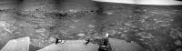
Sol 3389 the Navcam panoramic view.
Jan van Driel
|
|
 |
 
|
|
|
Aug 27 2013, 09:59 AM
Post
#47
|
||
|
Senior Member Group: Members Posts: 2820 Joined: 22-April 05 From: Ridderkerk, Netherlands Member No.: 353 |
and the last one.
Sol 3389. Looking back. Jan van Driel
|
|
|
|
|
|
|
Aug 28 2013, 06:08 PM
Post
#48
|
||
|
Senior Member Group: Moderator Posts: 4279 Joined: 19-April 05 From: .br at .es Member No.: 253 |
Here's part of a "post-drive" navcam mosaic shot on sol 3410.
|
|
|
|
|
|
|
Aug 29 2013, 06:45 PM
Post
#49
|
||
|
Senior Member Group: Members Posts: 2820 Joined: 22-April 05 From: Ridderkerk, Netherlands Member No.: 353 |
The Navcam L0 panoramic view on Sol 3410.
Jan van Driel
|
|
|
|
|
|
|
Aug 30 2013, 06:34 PM
Post
#50
|
||
 Senior Member Group: Moderator Posts: 3431 Joined: 11-August 04 From: USA Member No.: 98 |
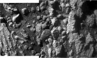
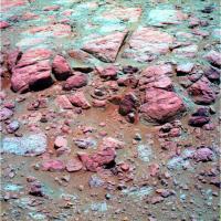
"Coal Island", Sol 3412. After taking these Pancam images she turned around and advanced slightly toward the target.
Attached thumbnail(s)
|
|
|
|
|
|
|
Aug 30 2013, 10:50 PM
Post
#51
|
|
|
Senior Member Group: Members Posts: 1043 Joined: 17-February 09 Member No.: 4605 |
So is "Coal Island" the outcrop of what, from a distance, looks as if it could be more vesicular basalt, or the transition from planar to cross stratified laminae in the left image?
|
|
|
|
|
Aug 31 2013, 12:33 PM
Post
#52
|
||
|
Senior Member Group: Members Posts: 2820 Joined: 22-April 05 From: Ridderkerk, Netherlands Member No.: 353 |
Sol 3412 the L0 navcam view.
Jan van Driel
|
|
|
|
|
|
|
Aug 31 2013, 09:15 PM
Post
#53
|
||
|
Solar System Cartographer Group: Members Posts: 10153 Joined: 5-April 05 From: Canada Member No.: 227 |
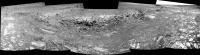
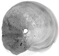
This is the sol 3410 panorama posted by jvandriel (Thanks!) in a circular version. It gives a nice view of the tracks and surrounding features.
Phil
-------------------- ... because the Solar System ain't gonna map itself.
Also to be found posting similar content on https://mastodon.social/@PhilStooke Maps for download (free PD: https://upload.wikimedia.org/wikipedia/comm...Cartography.pdf NOTE: everything created by me which I post on UMSF is considered to be in the public domain (NOT CC, public domain) |
|
|
|
|
|
|
Aug 31 2013, 10:00 PM
Post
#54
|
||
|
Solar System Cartographer Group: Members Posts: 10153 Joined: 5-April 05 From: Canada Member No.: 227 |
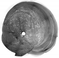
Another circular view from jvandriel's nice panoramas - this is sol 3407.
Phil
-------------------- ... because the Solar System ain't gonna map itself.
Also to be found posting similar content on https://mastodon.social/@PhilStooke Maps for download (free PD: https://upload.wikimedia.org/wikipedia/comm...Cartography.pdf NOTE: everything created by me which I post on UMSF is considered to be in the public domain (NOT CC, public domain) |
|
|
|
|
|
|
Sep 2 2013, 04:25 PM
Post
#55
|
||
|
Senior Member Group: Members Posts: 1074 Joined: 21-September 07 From: Québec, Canada Member No.: 3908 |
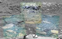
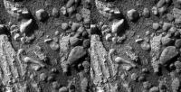
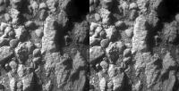
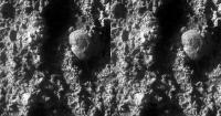
Two sol 3415 MI images stitched together:
|
|
|
|
|
|
|
Sep 3 2013, 11:24 AM
Post
#56
|
||
|
Senior Member Group: Members Posts: 1074 Joined: 21-September 07 From: Québec, Canada Member No.: 3908 |
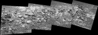
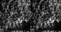
Sol 3416 pancam mosaic (Coal Island):
|
|
|
|
|
|
|
Sep 3 2013, 11:26 PM
Post
#57
|
|||
|
Member Group: Members Posts: 866 Joined: 15-March 05 From: Santa Cruz, CA Member No.: 196 |
they seem to be doing some stereo imaging by pitching the camera vertically.. a new technique? i hadn't noticed this before. I rotated the images ccw with shadows down here as that goes easier on the eyes at least for these Sol 3415 crosseyes.
i see 'leg-o-lamb' on the left ?! |
||
|
|
|
||
|
Sep 4 2013, 03:18 PM
Post
#58
|
||
|
Solar System Cartographer Group: Members Posts: 10153 Joined: 5-April 05 From: Canada Member No.: 227 |
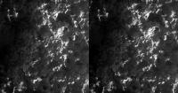
False color (very false) of the scarp from sol 3417. Interesting little 'red' pebbles here and there. Not really red of course.
Phil
-------------------- ... because the Solar System ain't gonna map itself.
Also to be found posting similar content on https://mastodon.social/@PhilStooke Maps for download (free PD: https://upload.wikimedia.org/wikipedia/comm...Cartography.pdf NOTE: everything created by me which I post on UMSF is considered to be in the public domain (NOT CC, public domain) |
|
|
|
|
|
|
Sep 5 2013, 12:49 AM
Post
#59
|
||||
|
Member Group: Members Posts: 866 Joined: 15-March 05 From: Santa Cruz, CA Member No.: 196 |
A few more interesting cross-eyes (ccw90 rotated)
Sol3378-->
|
|||
|
|
|
|||
|
Sep 5 2013, 03:08 AM
Post
#60
|
|
 Senior Member Group: Members Posts: 4246 Joined: 17-January 05 Member No.: 152 |
I'm sure many of us were surprized at how close we got to Mulla Mulla. It turns out it really was a close call. From the latest PS update:
QUOTE While navigating the boulder field in mid-August, Opportunity apparently came frighteningly close to running into a boulder called Mulla Mulla. "It was a near miss," said Bill Nelson... "We could have easily collided with the rock and damaged the rover. Through sheer luck, we didn't." As it turned out, Opportunity didn't even so much suffer a scrape... But it might have been mission catastrophic... and it happened because of human error. "This is an operational error and it's a big deal," said Callas. As a result, the incident generated what is known as an Incident Surprise Anomaly (ISA) report. "We want to thoroughly understand why our process didn't catch it, because it should have. The issue stemmed from a mis-positioning of the 'keep out' zone around the rock. "In hindsight, if you look at it, you go - 'Oh yeah that 'keep out' zone wasn't positioned correctly.' But no one caught that," Callas said. Yikes! |
|
|
|
|

|
Lo-Fi Version | Time is now: 27th April 2024 - 02:16 AM |
|
RULES AND GUIDELINES Please read the Forum Rules and Guidelines before posting. IMAGE COPYRIGHT |
OPINIONS AND MODERATION Opinions expressed on UnmannedSpaceflight.com are those of the individual posters and do not necessarily reflect the opinions of UnmannedSpaceflight.com or The Planetary Society. The all-volunteer UnmannedSpaceflight.com moderation team is wholly independent of The Planetary Society. The Planetary Society has no influence over decisions made by the UnmannedSpaceflight.com moderators. |
SUPPORT THE FORUM Unmannedspaceflight.com is funded by the Planetary Society. Please consider supporting our work and many other projects by donating to the Society or becoming a member. |
|