Opportunity Route Map |

  |
Opportunity Route Map |
 Feb 20 2015, 06:31 AM Feb 20 2015, 06:31 AM
Post
#3331
|
|
|
Founder  Group: Chairman Posts: 14431 Joined: 8-February 04 Member No.: 1 |
42,195 will be the Marathon line. Not far at all

|
 |
 
|
|
Feb 20 2015, 04:45 PM
Post
#3332
|
||
|
Solar System Cartographer Group: Members Posts: 10150 Joined: 5-April 05 From: Canada Member No.: 227 |
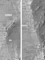
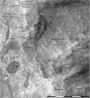
Here's a summary of our activities on Cape Tribulation:
Phil
-------------------- ... because the Solar System ain't gonna map itself.
Also to be found posting similar content on https://mastodon.social/@PhilStooke NOTE: everything created by me which I post on UMSF is considered to be in the public domain (NOT CC, public domain) |
|
|
|
|
|
|
Feb 20 2015, 04:49 PM
Post
#3333
|
||
|
Solar System Cartographer Group: Members Posts: 10150 Joined: 5-April 05 From: Canada Member No.: 227 |
... and an update of the last detailed map. The white squares are sites of in situ observations (any combination of APXS and MI activities with the arm)
Phil
-------------------- ... because the Solar System ain't gonna map itself.
Also to be found posting similar content on https://mastodon.social/@PhilStooke NOTE: everything created by me which I post on UMSF is considered to be in the public domain (NOT CC, public domain) |
|
|
|
|
|
|
Feb 28 2015, 10:14 PM
Post
#3334
|
||
|
Solar System Cartographer Group: Members Posts: 10150 Joined: 5-April 05 From: Canada Member No.: 227 |
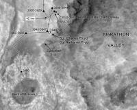
We just moved away from the cliffs and down towards the valley on sol 3945. I only have a very vague idea about location and path, so this will be corrected later.
Phil
-------------------- ... because the Solar System ain't gonna map itself.
Also to be found posting similar content on https://mastodon.social/@PhilStooke NOTE: everything created by me which I post on UMSF is considered to be in the public domain (NOT CC, public domain) |
|
|
|
|
|
|
Mar 4 2015, 12:58 AM
Post
#3335
|
||
|
Solar System Cartographer Group: Members Posts: 10150 Joined: 5-April 05 From: Canada Member No.: 227 |
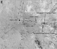
Update to sol 3948, making quite a big correction to the previous position now we have a full pan down.
Phil
-------------------- ... because the Solar System ain't gonna map itself.
Also to be found posting similar content on https://mastodon.social/@PhilStooke NOTE: everything created by me which I post on UMSF is considered to be in the public domain (NOT CC, public domain) |
|
|
|
|
|
|
Mar 18 2015, 03:56 PM
Post
#3336
|
||
|
Solar System Cartographer Group: Members Posts: 10150 Joined: 5-April 05 From: Canada Member No.: 227 |
Another move - looks like we are on our way down to the valley now. The position is only approximate at the moment.
Phil
-------------------- ... because the Solar System ain't gonna map itself.
Also to be found posting similar content on https://mastodon.social/@PhilStooke NOTE: everything created by me which I post on UMSF is considered to be in the public domain (NOT CC, public domain) |
|
|
|
|
|
|
Mar 22 2015, 02:46 PM
Post
#3337
|
||
|
Solar System Cartographer Group: Members Posts: 10150 Joined: 5-April 05 From: Canada Member No.: 227 |
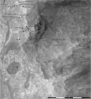
Down in the valley at last! This location is good, but the path is conjectural until I know more. EDIT - replaced with a good path from a useful tweet... thanks, Mike.
Phil
-------------------- ... because the Solar System ain't gonna map itself.
Also to be found posting similar content on https://mastodon.social/@PhilStooke NOTE: everything created by me which I post on UMSF is considered to be in the public domain (NOT CC, public domain) |
|
|
|
|
|
|
Mar 22 2015, 03:01 PM
Post
#3338
|
||
|
Solar System Cartographer Group: Members Posts: 10150 Joined: 5-April 05 From: Canada Member No.: 227 |
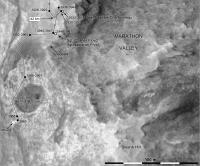
And a detailed map of the area around our last stop.
Phil
-------------------- ... because the Solar System ain't gonna map itself.
Also to be found posting similar content on https://mastodon.social/@PhilStooke NOTE: everything created by me which I post on UMSF is considered to be in the public domain (NOT CC, public domain) |
|
|
|
|
|
|
Mar 24 2015, 10:16 PM
Post
#3339
|
|
|
Member Group: Members Posts: 866 Joined: 15-March 05 From: Santa Cruz, CA Member No.: 196 |
NASA's Opportunity Mars Rover Passes Marathon Distance http://www.jpl.nasa.gov/news/news.php?feature=4521
"There was no tape draped across a finish line, but NASA is celebrating a win. The agency's Mars Exploration Rover Opportunity completed its first Red Planet marathon Tuesday -- 26.219 miles (42.195 kilometers) - with a finish time of roughly 11 years and two months"................ |
|
|
|
|
Mar 25 2015, 12:03 AM
Post
#3340
|
||
|
Solar System Cartographer Group: Members Posts: 10150 Joined: 5-April 05 From: Canada Member No.: 227 |
Update to sol 3968.
Phil
-------------------- ... because the Solar System ain't gonna map itself.
Also to be found posting similar content on https://mastodon.social/@PhilStooke NOTE: everything created by me which I post on UMSF is considered to be in the public domain (NOT CC, public domain) |
|
|
|
|
|
|
Mar 25 2015, 09:49 AM
Post
#3341
|
|
|
Senior Member Group: Members Posts: 2920 Joined: 14-February 06 From: Very close to the Pyrénées Mountains (France) Member No.: 682 |
If we add Spirit ride, MER proogram is short of 75m for roving 50 km (42195 + 7780)

-------------------- |
|
|
|
|
Mar 25 2015, 09:59 PM
Post
#3342
|
||
|
Solar System Cartographer Group: Members Posts: 10150 Joined: 5-April 05 From: Canada Member No.: 227 |
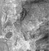
Another move to approach Athens, the light-toned outcrop.
Phil
-------------------- ... because the Solar System ain't gonna map itself.
Also to be found posting similar content on https://mastodon.social/@PhilStooke NOTE: everything created by me which I post on UMSF is considered to be in the public domain (NOT CC, public domain) |
|
|
|
|
|
|
Apr 5 2015, 12:22 AM
Post
#3343
|
||
|
Solar System Cartographer Group: Members Posts: 10150 Joined: 5-April 05 From: Canada Member No.: 227 |
I've made a few modifications to the map... not sure I have the Speckled Hill-Swann Hill business sorted out yet.
Phil
-------------------- ... because the Solar System ain't gonna map itself.
Also to be found posting similar content on https://mastodon.social/@PhilStooke NOTE: everything created by me which I post on UMSF is considered to be in the public domain (NOT CC, public domain) |
|
|
|
|
|
|
Apr 24 2015, 12:47 PM
Post
#3344
|
||
|
Solar System Cartographer Group: Members Posts: 10150 Joined: 5-April 05 From: Canada Member No.: 227 |
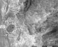
Update to sol 3998, moving up to the edge of Spirit of St. Louis. This is only based on reported distance and direction as I have no images yet.
Phil
-------------------- ... because the Solar System ain't gonna map itself.
Also to be found posting similar content on https://mastodon.social/@PhilStooke NOTE: everything created by me which I post on UMSF is considered to be in the public domain (NOT CC, public domain) |
|
|
|
|
|
|
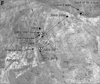
Apr 26 2015, 10:12 PM
Post
#3345
|
||
|
Solar System Cartographer Group: Members Posts: 10150 Joined: 5-April 05 From: Canada Member No.: 227 |
Update to sol 4000 - amazing! The latest positions may not be quite right as I still don't have images. Maps like these made from reprojected panoramas will contain relief distortions which I can't remove at this stage.
Phil
-------------------- ... because the Solar System ain't gonna map itself.
Also to be found posting similar content on https://mastodon.social/@PhilStooke NOTE: everything created by me which I post on UMSF is considered to be in the public domain (NOT CC, public domain) |
|
|
|
|
|
|

|
Lo-Fi Version | Time is now: 23rd April 2024 - 08:45 PM |
|
RULES AND GUIDELINES Please read the Forum Rules and Guidelines before posting. IMAGE COPYRIGHT |
OPINIONS AND MODERATION Opinions expressed on UnmannedSpaceflight.com are those of the individual posters and do not necessarily reflect the opinions of UnmannedSpaceflight.com or The Planetary Society. The all-volunteer UnmannedSpaceflight.com moderation team is wholly independent of The Planetary Society. The Planetary Society has no influence over decisions made by the UnmannedSpaceflight.com moderators. |
SUPPORT THE FORUM Unmannedspaceflight.com is funded by the Planetary Society. Please consider supporting our work and many other projects by donating to the Society or becoming a member. |
|