Charon Surface Observations: NH Post-Encounter Phase, 1 Aug 2015- TBD |

  |
Charon Surface Observations: NH Post-Encounter Phase, 1 Aug 2015- TBD |
 Aug 1 2015, 06:02 PM Aug 1 2015, 06:02 PM
Post
#1
|
|
|
Merciless Robot  Group: Admin Posts: 8784 Joined: 8-December 05 From: Los Angeles Member No.: 602 |
This topic is for images and discussion of same received after 1 Aug 2015.
-------------------- A few will take this knowledge and use this power of a dream realized as a force for change, an impetus for further discovery to make less ancient dreams real.
|
 |
 
|
|
Aug 2 2015, 07:49 AM
Post
#2
|
|
 Junior Member Group: Members Posts: 82 Joined: 13-July 15 Member No.: 7579 |
QUOTE (fredk @ Aug 2 2015, 07:50 PM)  What makes you say that? Yes, frame was taken 2015-07-16 03:44:20 UTC, more than a day after encounter. Post deleted. Sorry for my mistake. |
|
|
|
|
Aug 2 2015, 02:50 PM
Post
#3
|
|
 Senior Member Group: Members Posts: 4247 Joined: 17-January 05 Member No.: 152 |
QUOTE (Gennady Ionov @ Aug 2 2015, 08:49 AM) the Sun is behind the Charon's disc What makes you say that? The size of Charon in that post-encounter frame is roughly similar to its size in this frame: http://pluto.jhuapl.edu/soc/Pluto-Encounte...0x632_sci_1.jpg That pre-encounter frame was taken more than a day before closest approach, so the post-encounter frame had to be taken roughly a day after closest approach. But the Charon-sun occultation occured only 2h 15m after closest approach. So the sun must be outside the frame on that Charon crescent image. |
|
|
|
|
Aug 2 2015, 03:56 PM
Post
#4
|
|
 Member Group: Members Posts: 244 Joined: 2-March 15 Member No.: 7408 |
The picture fredk linked was taken from a range of 1,462,006 km, according to the metadata file.
The crescent image was taken from a range of 1,986,740 km, according to the metadata file, and since apparent diameter has a simple, inverse relationship with distance, Charon should be about 73.6% the size it was in the image fredk linked. Not that that adds anything to the conversation |
|
|
|
|
Aug 4 2015, 06:21 PM
Post
#5
|
|
|
Junior Member Group: Members Posts: 82 Joined: 13-July 15 Member No.: 7579 |
QUOTE (JRehling @ Aug 4 2015, 11:04 PM) Checking the orbital positions, there were Charonshine opportunities for imaging Pluto on July 14, July 20, etc. and Plutoshine opportunities for imaging Charon on July 17, July 23, etc. If we get some regional albedo information for the mid-southern latitudes, that would be great. A bonus would be if we get some details and/or could see if Charon has a dark region at the other pole, too. I'd love to see something like the Saturnshine images of Iapetus, but I'm not getting my hopes up. Yes! I hope that Charon has a dark region at the southern pole, because I believe that Mordor Regio resulted from leakage of ice from the equator in the relaxation process of Charon nonsphericity during deceleration of rotation. |
|
|
|
|
Aug 6 2015, 08:53 PM
Post
#6
|
|
 Senior Member Group: Members Posts: 1887 Joined: 20-November 04 From: Iowa Member No.: 110 |
|
|
|
|
|
Aug 7 2015, 12:41 AM
Post
#7
|
|
|
Senior Member Group: Members Posts: 2998 Joined: 30-October 04 Member No.: 105 |
This appears to be a ~ half-size (5000px wide vs 9520px wide) of the previously-released PIA19866 with no new data added, for those who have the earlier map.
http://photojournal.jpl.nasa.gov/catalog/PIA19866 --Bill -------------------- |
|
|
|
|
Aug 10 2015, 04:25 PM
Post
#8
|
||
 IMG to PNG GOD Group: Moderator Posts: 2251 Joined: 19-February 04 From: Near fire and ice Member No.: 38 |
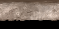
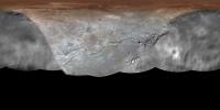
Here is an updated version of my map of Charon. The main changes are the addition of color (areas where no color was available are colorized) and the addition of a single 400 m/pixel image. Compared to the official map, there are some positional errors (typically ~10 pixels; more near the pole) but they do not affect the overall appearance of the map. Longitude 0 is at the left edge of the map.
I'll probably redo the map completely at higher resolution later this year. |
|
|
|
|
|
|
Aug 10 2015, 04:54 PM
Post
#9
|
|
 Senior Member Group: Members Posts: 1639 Joined: 5-March 05 From: Boulder, CO Member No.: 184 |
Nice map. I appreciate in particular the images are blended more smoothly at the boundaries than we often see in the official versions.
-------------------- Steve [ my home page and planetary maps page ]
|
|
|
|
|
Aug 18 2015, 05:21 PM
Post
#10
|
|
|
Senior Member Group: Members Posts: 2998 Joined: 30-October 04 Member No.: 105 |
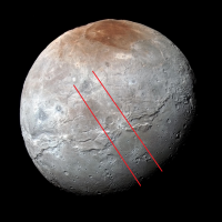
Charon is turning out to be a delightfully complex and fascinating world. It has a polar crater-caldera, a system of lineations with a complex equatorial fracture system, a cratering history and a north-south dichotomy as well as seasonal frosts. Much more than the little Pluto tag-along we were thinking it was.
I am doing a presentation on the Geomorphology of Charon. As always, it is a work-in-progress, so check back: LORRI-MVIC combined imagery https://univ.smugmug.com/New-Horizons-Missi...2B%20MVIC-L.png Preliminary Geomorph of Charon https://univ.smugmug.com/New-Horizons-Missi...orph-v1.0-L.png --Bill -------------------- |
|
|
|
|
Sep 10 2015, 06:41 PM
Post
#11
|
|
|
Senior Member Group: Members Posts: 1887 Joined: 20-November 04 From: Iowa Member No.: 110 |
Upgraded image released
QUOTE This image of Pluto's largest moon Charon, taken by NASA's New Horizons spacecraft 10 hours before its closest approach to Pluto on July 14, 2015 from a distance of 290,000 miles (470,000 kilometers), is a recently downlinked, much higher quality version of a Charon image released on July 15. I wonder if this means other LORRI images currently posted will be replaced by less compressed versions tomorrow. |
|
|
|
|
Sep 10 2015, 07:03 PM
Post
#12
|
||
 Member Group: Members Posts: 423 Joined: 13-November 14 From: Norway Member No.: 7310 |
Charon's north pole looks to me like it could have a relatively young surface - or just having craters as dark as their surroundings?
-------------------- |
|
|
|
|
|
|
Sep 10 2015, 07:19 PM
Post
#13
|
|
|
Senior Member Group: Members Posts: 1583 Joined: 14-October 05 From: Vermont Member No.: 530 |
NH Blog post today about how the red pole may be tholins left behind after some of Pluto's atmosphere freezes onto Charon's dark pole, only to sublimate away leaving behind trace tholins:
https://blogs.nasa.gov/pluto/2015/09/09/new...arons-red-pole/ |
|
|
|
|
Sep 11 2015, 07:34 PM
Post
#14
|
|
 Member Group: Members Posts: 796 Joined: 27-February 08 From: Heart of Europe Member No.: 4057 |
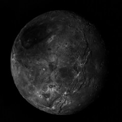
Colorized image of Charon from the newly published images.
2 stacked images colorized using MVIC data. Resolution 2.3 km/pix. 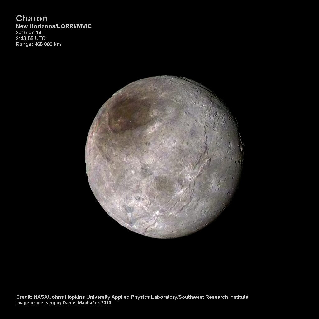
-------------------- |
|
|
|
|
Sep 11 2015, 09:29 PM
Post
#15
|
|
|
Senior Member Group: Members Posts: 3516 Joined: 4-November 05 From: North Wales Member No.: 542 |
QUOTE (stevesliva @ Sep 10 2015, 08:19 PM) NH Blog post today about how the red pole may be tholins left behind after some of Pluto's atmosphere freezes onto Charon's dark pole, only to sublimate away leaving behind trace tholins: Nice theory. If correct this must be a very slow or no longer active process as we see a few bright impact craters punched into it. Wonderful image NH/machi. 
|
|
|
|
|
Sep 25 2015, 07:16 PM
Post
#16
|
|
|
Senior Member Group: Members Posts: 1887 Joined: 20-November 04 From: Iowa Member No.: 110 |
new images as the LORRI site
http://pluto.jhuapl.edu/soc/Pluto-Encounte...er=downlinkDate |
|
|
|
|
Sep 25 2015, 07:25 PM
Post
#17
|
|
|
Member Group: Members Posts: 423 Joined: 13-November 14 From: Norway Member No.: 7310 |
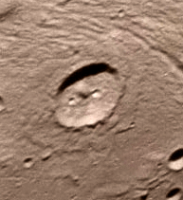
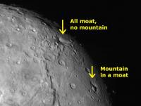
Baby mountain-in-a-moat?
 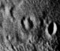 (notice the difference to the similar-sized crater next to it) In general, quite a lot of mountainous structures on those plains. -------------------- |
|
|
|
|
Sep 25 2015, 08:08 PM
Post
#18
|
||
|
Junior Member Group: Members Posts: 82 Joined: 13-July 15 Member No.: 7579 |
QUOTE (Gennady Ionov @ Aug 3 2015, 07:30 PM) Another interesting feature of relief: small dimples. I suppose that it is an analogue of the dunes in the desert, caused not by the wind but solar irradiation conditions. Oriented to the Sun the north side evaporates and on the shady south sides condensation occurs. Thus, the instability of a flat surface develops and slowly creeping dunes to the south (when in the northern hemisphere is summer). Therefore, the perpendicular meridians orientation of formations can be observed. It looks like the similar dunes seen on Charon. Dunes caused by instability of flat surface due to instability under slanting rays of the sun. At least Charon dunes definitely can not be caused by wind.
|
|
|
|
|
|
|
Sep 25 2015, 08:56 PM
Post
#19
|
|
|
Senior Member Group: Members Posts: 2998 Joined: 30-October 04 Member No.: 105 |
QUOTE (Alan) new images as the LORRI site They do have the Additn'l Info as "LORRI rider on P_MPAN_1 scan observation", and there is an button to show by release date, but I don't see any _release_date_ info on the images. Have I missed something? and a reminder of my NH Charon geomorph image: https://univ.smugmug.com/New-Horizons-Missi...omorph-v1.0.png --Bill -------------------- |
|
|
|
|
Sep 25 2015, 09:01 PM
Post
#20
|
|
|
Member Group: Members Posts: 890 Joined: 18-November 08 Member No.: 4489 |
|
|
|
|
|
Sep 25 2015, 09:07 PM
Post
#21
|
|
 Lord Of The Uranian Rings Group: Members Posts: 798 Joined: 18-July 05 From: Plymouth, UK Member No.: 437 |
-------------------- |
|
|
|
|
Sep 25 2015, 09:38 PM
Post
#22
|
|
|
Junior Member Group: Members Posts: 48 Joined: 10-September 06 Member No.: 1129 |
Charon looks far less cratered than Callisto, Ceres, Mimas, Tethys, Dione, Rhea, and Iapetus (plus Umbriel, Titania, and Oberon based on lower resolution images).
Perhaps we're looking at a surface age closer to that of Ganymede, Miranda, and Ariel? |
|
|
|
|
Sep 26 2015, 07:02 AM
Post
#23
|
|
|
Member Group: Members Posts: 306 Joined: 4-October 14 Member No.: 7273 |
My attempt at stitching together the Charon mosaic that was uploaded on the raw website today. Tried my hand at colorizing it with the MVIC image taken on July 13. I had to warp the image to align with low resolution + Charon's rotation making that difficult, so color features should be taken with a *huge* grain of salt.
|
|
|
|
|
Sep 26 2015, 08:42 AM
Post
#24
|
|
 Member Group: Members Posts: 810 Joined: 3-June 04 From: Brittany, France Member No.: 79 |
Really nice work Justin !
-------------------- |
|
|
|
|
Sep 26 2015, 04:21 PM
Post
#25
|
||
|
Member Group: Members Posts: 423 Joined: 13-November 14 From: Norway Member No.: 7310 |
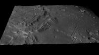
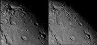
With the latest high-resolution imagery down, it really looks like there is significant topography at the north pole (there certainly is on the horizon). Using jccwrt's work above (rotated to make north up(wards)), it's tempting to interpret this part as a mountain range (perhaps encircling the entire northernmost area), entering and leaving the field of view on the right side in this image:
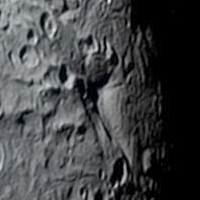
I also found this crater interesting, since it appeared kind of shallow - as if something had happened to its floor: 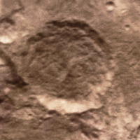 And of course there is this crater (to the right), which looks completely filled in: 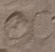 Dome? 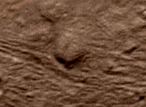 Landslides from some of the big cliffs:  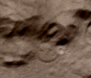 (look impact-related) -------------------- |
|
|
|
|
|
|
Sep 26 2015, 06:13 PM
Post
#26
|
|
|
Senior Member Group: Members Posts: 2998 Joined: 30-October 04 Member No.: 105 |
It seems that Charon has Cerean topography, especially the "flowage" and "slumpage" features.
And my take on Mordor (the Polar Feature) is that it appears to be a caldera/crater. Ref my "Pluto/Charon" and "Ceres" pages linked below. What strange little worlds. --Bill -------------------- |
|
|
|
|
Sep 26 2015, 11:37 PM
Post
#27
|
||
|
Member Group: Members Posts: 306 Joined: 4-October 14 Member No.: 7273 |
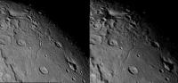
QUOTE (neo56 @ Sep 26 2015, 02:42 AM) Really nice work Justin ! Thank you! QUOTE (Habukaz @ Sep 26 2015, 10:21 AM) With the latest high-resolution imagery down, it really looks like there is significant topography at the north pole (there certainly is on the horizon). Using jccwrt's work above (rotated to make north up(wards)), it's tempting to interpret this part as a mountain range (perhaps encircling the entire northernmost area), entering and leaving the field of view on the right side in this image. It could be a mountain range. My first thought was that it was another large fissure system seen edge on. Of course, at the scale of some of these, there's functionally not much difference!  It is interesting that it is "walling in" some of the darker terrain around the north pole - I wonder if it's either creating a cold trap that keeps the north pole in winter darkness for a little longer. It is interesting that it is "walling in" some of the darker terrain around the north pole - I wonder if it's either creating a cold trap that keeps the north pole in winter darkness for a little longer.As for the infilled crater, it looks pretty old and degraded, so there's a possibility that it could just be infilled with ejecta from other impacts. That said it's on relatively flat terrain so there might have been some mare-like flow into the crater. Hopefully we'll get another hi-res image to get some context to the eastern rim of that crater. This crater (directly north of Moat Mountain) looks interesting, could be a potential terrace impact. Looks relatively young, too. Some of the ejecta is covering nearby tectonic features.
|
|
|
|
|
|
|
Sep 29 2015, 03:30 PM
Post
#28
|
|
|
Senior Member Group: Members Posts: 2998 Joined: 30-October 04 Member No.: 105 |
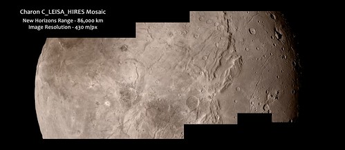
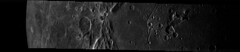
These latest Charon images, five in a montage-able series described as "LORRI rider on C_LEISA_HIRES scan" are a great improvement on the initial Charon images.
When these images hit PDS as verified and calibrated etc they should be better than these initial jpeg'd public offerings, so there is room for improvement. But with later data transfer from NH, should there be higher resolution images of this series to look forward to? And could there be other images north and south of these to give a montage of the entire hemisphere or was this one track pretty much it? Still, these images show astounding detail and amazing features on this little world. Take a look: https://univ.smugmug.com/New-Horizons-Missi...haron/i-wQNMfhT --Bill -------------------- |
|
|
|
|
Sep 29 2015, 04:16 PM
Post
#29
|
|
|
Member Group: Members Posts: 306 Joined: 4-October 14 Member No.: 7273 |
According to machi's table of planned LORRI observations it appears there was a scan across Charon at 170 m/px resolution. As for the C_LEISA_HIRES observation, there were apparently 12 shots planned in this sequence. I'm not sure if that means that this will cover the entire globe of Charon or if there were just multiple images taken to increase SNR like some of the LORRI observations of Pluto. Considering that this is a ride-along observation, I'd guess the latter.
|
|
|
|
|
Sep 29 2015, 04:20 PM
Post
#30
|
|
|
Senior Member Group: Members Posts: 1887 Joined: 20-November 04 From: Iowa Member No.: 110 |
There was a mosaic taken at 175,000 km which should cover the entire hemisphere at a resolution 0.87km/px ,similar to the 16 frame mosaic of Pluto posted a couple of weeks ago; an MVIC color image from 76,000 km, resolution 1.5km/px; and a narrow pass from 34,000 km, resolution 0.17km/px, with a concurrent MVIC image at 0.66km/px.
|
|
|
|
|
Sep 29 2015, 11:53 PM
Post
#31
|
|
|
Senior Member Group: Members Posts: 2998 Joined: 30-October 04 Member No.: 105 |
Still, that is good. The recent images have so much going on. Later images transmitted and images on-the-ground-but-going-to PDS can only sweeten things.
https://univ.smugmug.com/New-Horizons-Missi..._5x1--annot.png --Bill -------------------- |
|
|
|
|
Oct 1 2015, 05:06 PM
Post
#32
|
|
 Member Group: Members Posts: 568 Joined: 20-April 05 From: Silesia Member No.: 299 |
-------------------- Free software for planetary science (including Cassini Image Viewer).
http://members.tripod.com/petermasek/marinerall.html |
|
|
|
|
Oct 1 2015, 05:07 PM
Post
#33
|
||
|
Junior Member Group: Members Posts: 80 Joined: 14-February 04 Member No.: 32 |
QUOTE (peter59 @ Oct 1 2015, 12:06 PM) And more details:
Attached thumbnail(s)
-------------------- - Lars
|
|
|
|
|
|
|
Oct 1 2015, 05:18 PM
Post
#34
|
|
|
Member Group: Members Posts: 423 Joined: 13-November 14 From: Norway Member No.: 7310 |
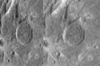
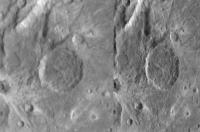
Didn't notice this one earlier. Curious feature:
 moat without a mountain. -------------------- |
|
|
|
|
Oct 1 2015, 07:47 PM
Post
#35
|
||
|
Senior Member Group: Members Posts: 1887 Joined: 20-November 04 From: Iowa Member No.: 110 |
My estimate of the highest resolution track
|
|
|
|
|
|
|
Oct 1 2015, 08:08 PM
Post
#36
|
|
|
Member Group: Members Posts: 220 Joined: 13-October 05 Member No.: 528 |
What is the highest resolution we expect? I recall reading it in a journal article that I no longer have a link to. Something around 140 M/pixel is what comes to mind.
|
|
|
|
|
Oct 1 2015, 11:29 PM
Post
#37
|
|
|
Senior Member Group: Members Posts: 2998 Joined: 30-October 04 Member No.: 105 |
Whoa. Great images today for us Charon-ites.
Good color: http://pluto.jhuapl.edu/Multimedia/Science...mp;image_id=323 The hi-res track with color: http://pluto.jhuapl.edu/Multimedia/Science...mp;image_id=324 Charon and Pluto: http://pluto.jhuapl.edu/Multimedia/Science...mp;image_id=325 A CGI riff: http://pluto.jhuapl.edu/Multimedia/Science...mp;image_id=326 And of course, that '70's Gold to hum along with, by The Knack: "My Charona": www.youtube.com/watch?v=g1T71PGd-J0 I'll be up for air by Sunday...  --Bill -------------------- |
|
|
|
|
Oct 2 2015, 11:42 AM
Post
#38
|
|
|
Member Group: Members Posts: 137 Joined: 16-June 15 Member No.: 7507 |
Does anyone know, at what point on Charon's surface is the center of the Pluto-facing side?
|
|
|
|
|
Oct 2 2015, 12:49 PM
Post
#39
|
|
|
Senior Member Group: Members Posts: 2998 Joined: 30-October 04 Member No.: 105 |
Zero lat, zero longitude?
-------------------- |
|
|
|
|
Oct 2 2015, 01:43 PM
Post
#40
|
|
|
Member Group: Members Posts: 910 Joined: 4-September 06 From: Boston Member No.: 1102 |
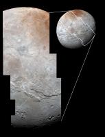
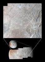
That would certainly be a logical convention for mapping... and I believe the correct one. The caption to the first Charon map released by nasa was:
Global map of Charon as of July 30, 2015. The map is in simple cylindrical projection, with zero longitude (the Pluto-facing direction) in the center. It includes all available resolved images of the moons surface captured between July 7-14, 2015 on the anti-Pluto facing hemisphere. Image credit: NASA / Johns Hopkins University Applied Physics Laboratory / Southwest Research Institute. -------------------- |
|
|
|
|
Oct 3 2015, 02:24 AM
Post
#41
|
|
 Senior Member Group: Members Posts: 1431 Joined: 26-July 08 Member No.: 4270 |
Could you add a link? (If you did, I can't see it from my device).
-------------------- -- Hungry4info (Sirius_Alpha)
|
|
|
|
|
Oct 3 2015, 05:41 AM
Post
#42
|
|
 Senior Member Group: Members Posts: 2173 Joined: 28-December 04 From: Florida, USA Member No.: 132 |
QUOTE (Hungry4info @ Oct 2 2015, 10:24 PM) Could you add a link? (If you did, I can't see it from my device). Is it the map linked in posts 6 and 7 of this thread? |
|
|
|
|
Oct 3 2015, 12:24 PM
Post
#43
|
|
|
Member Group: Members Posts: 910 Joined: 4-September 06 From: Boston Member No.: 1102 |
Yes, the maps in posts #6 & #7. Link
-------------------- |
|
|
|
|
Oct 3 2015, 01:06 PM
Post
#44
|
|
|
Senior Member Group: Members Posts: 1431 Joined: 26-July 08 Member No.: 4270 |
Got it. I thought you were suggesting there was a newer map that included the most recently released imagery.
-------------------- -- Hungry4info (Sirius_Alpha)
|
|
|
|
|
Oct 3 2015, 04:25 PM
Post
#45
|
|
|
Member Group: Members Posts: 910 Joined: 4-September 06 From: Boston Member No.: 1102 |
The recently released image is so beautiful, I'm not really looking forward to seeing it embedded in a cylindrical map with the low resolution fuzz all around...
-------------------- |
|
|
|
|
Oct 3 2015, 05:31 PM
Post
#46
|
||
 Member Group: Members Posts: 714 Joined: 3-January 08 Member No.: 3995 |
Interesting texture:
|
|
|
|
|
|
|
Oct 3 2015, 06:07 PM
Post
#47
|
|
|
Senior Member Group: Members Posts: 2920 Joined: 14-February 06 From: Very close to the Pyrénées Mountains (France) Member No.: 682 |
This one is from Apollo 11, rigth?
-------------------- |
|
|
|
|
Oct 4 2015, 10:08 PM
Post
#48
|
|
 Member Group: Members Posts: 146 Joined: 23-August 06 From: Vriezenveen, Netherlands Member No.: 1067 |
Has anyone made an updated map for Charon?
|
|
|
|
|
Oct 5 2015, 04:41 AM
Post
#49
|
||
 Member Group: Members Posts: 290 Joined: 29-December 05 From: Ottawa, ON Member No.: 624 |
It almost looks like this island broke apart from the mainland, was carried off and then listed in the Great Melt of the southern hemisphere.
Note how some of the parts fit, similar to South America and Africa.
|
|
|
|
|
|
|
Oct 5 2015, 04:11 PM
Post
#50
|
||
|
Newbie Group: Members Posts: 4 Joined: 29-June 15 Member No.: 7535 |
(Newbie here.) This track is not an image artefact, is it? The lower right corner indicates its location.
|
|
|
|
|
|
|
Oct 5 2015, 05:25 PM
Post
#51
|
|
|
Member Group: Members Posts: 244 Joined: 2-March 15 Member No.: 7408 |
QUOTE (TSC @ Oct 5 2015, 12:11 PM) (Newbie here.) This track is not an image artefact, is it? The lower right corner indicates its location. I don't think it's an artefact. It's hard to tell at this resolution, but it looks like a catena/crater chain to me. Not sure how common that should be this far out. |
|
|
|
|
Oct 5 2015, 06:56 PM
Post
#52
|
|
|
Senior Member Group: Members Posts: 2998 Joined: 30-October 04 Member No.: 105 |
QUOTE (HSchirmer @ Oct 5 2015, 11:20 AM) Not sure it's a clean fit, and it could also be a fissure where both edges erode back from the newly exposed surface... Yep, whenever I see that feature my first thought is that it's a wee crustal plate that has broken off and is drifting away. But then I look at it and although the "fit" of the break is good, it just doesn't "feel" right. Probably what I'll do is create an enlarged and enhanced view of that feature and put it out it for public review. I suspect that it is not so much a fracture and a drift as it is a landslide feature. I note that there is a similar set of fractures to the west making possibly a new "incipient allochthon". What a strange little world. --Bill -------------------- |
|
|
|
|
Oct 5 2015, 08:12 PM
Post
#53
|
||
|
Senior Member Group: Members Posts: 1639 Joined: 5-March 05 From: Boulder, CO Member No.: 184 |
QUOTE (CAP-Team @ Oct 4 2015, 10:08 PM) Has anyone made an updated map for Charon? Good question - here is a quick one at 4K resolution...
-------------------- Steve [ my home page and planetary maps page ]
|
|
|
|
|
|
|
Oct 5 2015, 09:24 PM
Post
#54
|
|
|
Member Group: Members Posts: 890 Joined: 18-November 08 Member No.: 4489 |
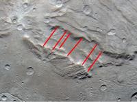
some alternate views of the rift and crater chain
sun set at a 45 deg elevation 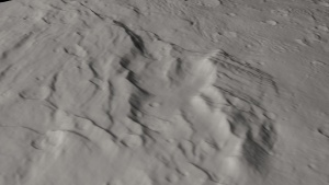  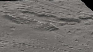  the chain 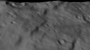 
|
|
|
|
|
Oct 5 2015, 09:32 PM
Post
#55
|
||
|
Senior Member Group: Members Posts: 3516 Joined: 4-November 05 From: North Wales Member No.: 542 |
QUOTE (Steve G @ Oct 5 2015, 05:41 AM) It almost looks like this island broke apart from the mainland, was carried off and then listed in the Great Melt of the southern hemisphere. Note how some of the parts fit, similar to South America and Africa.
The detached block is definitely tilted, suggesting it has moved, so I agree with the idea that it was once more horizontal and belonged to the northern 'continent'. As has been pointed out it may not have drifted horizontaly enough to produce the wide gap we now see. It is obviously fractured and different parts of it are tilted at different angles so to me it's not surprising that there isn't a perfect match up with the 'continental' boundary. I think as a general idea your suggestion runs. |
|
|
|
|
|
|
Oct 5 2015, 10:57 PM
Post
#56
|
||
|
Senior Member Group: Members Posts: 1639 Joined: 5-March 05 From: Boulder, CO Member No.: 184 |
Yes that block looked pretty interesting ever since the farther away images.
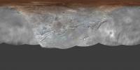
Here is a slightly cleaner map compared with what I posted earlier this afternoon.
-------------------- Steve [ my home page and planetary maps page ]
|
|
|
|
|
|
|
Oct 7 2015, 04:23 PM
Post
#57
|
|
|
Merciless Robot Group: Admin Posts: 8784 Joined: 8-December 05 From: Los Angeles Member No.: 602 |
MOD NOTE: 7 posts about N2 ice & putative polar caps moved to the Pluto System Speculation thread.
-------------------- A few will take this knowledge and use this power of a dream realized as a force for change, an impetus for further discovery to make less ancient dreams real.
|
|
|
|
|
Oct 9 2015, 03:54 AM
Post
#58
|
|
|
Senior Member Group: Members Posts: 2998 Joined: 30-October 04 Member No.: 105 |
QUOTE Here is a slightly cleaner map... That is great. And the "Beyond Here Lie Dragons" are looking fuzzier and fuzzier with each improvement of "Terra Cognito". Sadly, soooo tantalizing... I took this latest map and carefully selected the fuzzy area and applied an unsharp mask to bring out detail. It may have helped, but it's still a lost cause. I 'spect that a dondavis will need to go into the blurred areas and do "an artistic impression" of what they should ought to look like while we're waiting for a New Horizon's Orbiter. --Bill -------------------- |
|
|
|
|
Oct 9 2015, 04:02 PM
Post
#59
|
|
 Member Group: Members Posts: 227 Joined: 13-October 09 From: Olympus Mons Member No.: 4972 |
There is this map that could be included from occulations on Solarviews
http://solarviews.com/cap/pluto/charoncyl2.htm The low resolution areas of the NH map and Mordor appear well on it along with the bright area on the west side of the Pluto facing hemisphere. There is also big area of brightness on the southern hemisphere on it. Maybe there is an opposite colored "Mordor" there. -------------------- "Thats no moon... IT'S A TRAP!"
|
|
|
|
|
Oct 9 2015, 04:33 PM
Post
#60
|
|
 Senior Member Group: Members Posts: 2530 Joined: 20-April 05 Member No.: 321 |
QUOTE (Bill Harris @ Oct 8 2015, 08:54 PM) I took this latest map and carefully selected the fuzzy area and applied an unsharp mask to bring out detail. It may have helped, but it's still a lost cause. It's interesting to consider, generically, the spatial distribution of areal units on different worlds: If you see half the world, do you see all of the major areal types and morphological phenomena represented? Usually, the answer is yes. Some exceptions: Ishtar on Venus, the nearside maria on the Moon, Valles Marineris on Mars, the northern plains on Mars, the "ring of fire" around the Pacific on Earth, the northern seas on Titan, the active south polar region on Enceladus If you only saw the hemisphere "anti-" each of those things, you'd have no inkling of them represented in your data. Often, you'd have a lesser version of them, such as the farside maria on the Moon as a stand-in for the much broader nearside maria, but in some cases, you have no analogue at all. Still, these cases are the minority, so the odds are, we've seen the important stuff on Pluto and Charon already, with more of the same on the other side. But there's no guarantee of that, and we may have missed something crucial a Pluto equivalent of Tharsis or a Charon equivalent of Ishtar |
|
|
|
|
Oct 9 2015, 07:08 PM
Post
#61
|
|
|
Senior Member Group: Members Posts: 1887 Joined: 20-November 04 From: Iowa Member No.: 110 |
New images of Charon now at LORRI site http://pluto.jhuapl.edu/soc/Pluto-Encounte...Date&page=1
|
|
|
|
|
Oct 9 2015, 07:54 PM
Post
#63
|
|
 Senior Member Group: Members Posts: 3648 Joined: 1-October 05 From: Croatia Member No.: 523 |
QUOTE (Herobrine @ Oct 9 2015, 09:14 PM) All of the images are described as "Tight-deadband 2-sigma LORRI mosaic of Charon" The last 6 images you listed are not of Charon, they are described as : QUOTE This image may look blank but it actually contains a resolved image of Plutos smallest moon, Styx.
-------------------- |
|
|
|
|
Oct 9 2015, 09:07 PM
Post
#64
|
|
|
Member Group: Members Posts: 244 Joined: 2-March 15 Member No.: 7408 |
@ugordon Oops. Good catch. You are correct. The last 6 are described as "LORRI 2nd Portion" (in the same metadata field I used for the other description) and identified as "U_TBD_1_02". I was in a hurry to put together the below image and only checked a random half of the metadata files (managed to miss the Styx ones every time
).Here's a hand-stitched mosaic of the 11 Charon images.  (2400x2400, ~1.4 MiB) |
|
|
|
|
Oct 9 2015, 10:05 PM
Post
#65
|
|
|
Member Group: Members Posts: 796 Joined: 27-February 08 From: Heart of Europe Member No.: 4057 |
Stereo images of Charon using new LORRI images and older MVIC image.
Resolution is ~870 m/pix. Extremely interesting topography. 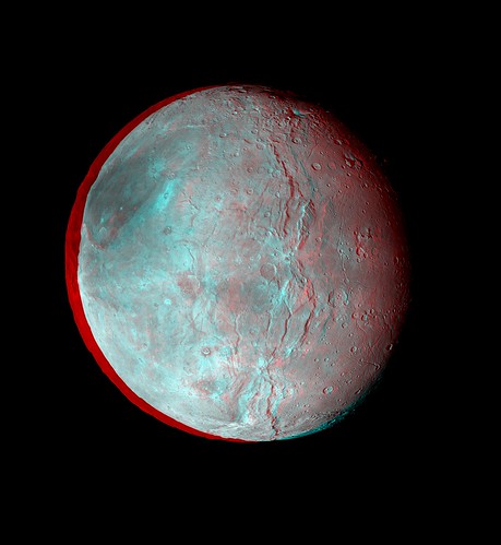 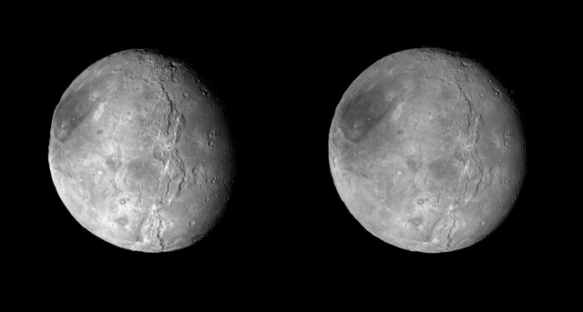 -------------------- |
|
|
|
|
Oct 10 2015, 01:42 PM
Post
#66
|
|
|
Member Group: Members Posts: 137 Joined: 16-June 15 Member No.: 7507 |
I think you've got your stereo backwards, it looks concave.
|
|
|
|
|
Oct 10 2015, 03:21 PM
Post
#67
|
|
|
Member Group: Members Posts: 148 Joined: 9-August 11 From: Mason, TX Member No.: 6108 |
QUOTE (Nafnlaus @ Oct 10 2015, 08:42 AM) I think you've got your stereo backwards, it looks concave. Cross-eyed looks fine to me... the canyons have depth. Behind the polar cap the terrain itself is definitely lumpy and somewhat excavated. I think that is a real feature. -------------------- --
Don |
|
|
|
|
Oct 10 2015, 03:55 PM
Post
#68
|
||
|
Member Group: Members Posts: 714 Joined: 3-January 08 Member No.: 3995 |
If y'all keep doing that cross-eyed method, your eyes will stay like that.
Anyway, Alan Stern retweeted this from Corey Powell:
https://twitter.com/coreyspowell/status/652757094387593216 'Moat without a mountain' next to a 'mountain with a moat'. I noticed that before but hadn't given it much thought. On second thought, quite interesting.... |
|
|
|
|
|
|
Oct 10 2015, 09:54 PM
Post
#69
|
|
|
Member Group: Members Posts: 315 Joined: 1-October 06 Member No.: 1206 |
Are these moats and mountains all within that moon-spanning spreading tectonic/rift zone?
Just asking. If so what implications might that have? P |
|
|
|
|
Oct 10 2015, 10:27 PM
Post
#70
|
|
|
Member Group: Members Posts: 137 Joined: 16-June 15 Member No.: 7507 |
QUOTE (MarsInMyLifetime @ Oct 10 2015, 03:21 PM) Cross-eyed looks fine to me... the canyons have depth. Behind the polar cap the terrain itself is definitely lumpy and somewhat excavated. I think that is a real feature. The whole moon looks concave, like looking into a bowl. |
|
|
|
|
Oct 10 2015, 11:02 PM
Post
#71
|
|
|
Senior Member Group: Members Posts: 4247 Joined: 17-January 05 Member No.: 152 |
The anaglyph is correct (for standard red/left and cyan/right glasses). The crosseyed is also correct. Maybe you're trying to view it parallel? That would invert the stereo.
|
|
|
|
|
Oct 10 2015, 11:37 PM
Post
#72
|
|
|
Member Group: Members Posts: 137 Joined: 16-June 15 Member No.: 7507 |
QUOTE (fredk @ Oct 10 2015, 10:02 PM) The anaglyph is correct (for standard red/left and cyan/right glasses). The crosseyed is also correct. Maybe you're trying to view it parallel? That would invert the stereo. Don't know what you mean by "view it parallel" - I'm just crossing my eyes and aligning the two images. Either way, it's not a big deal, I've always found these sort of images to not be that useful. |
|
|
|
|
Oct 11 2015, 01:03 AM
Post
#73
|
|
|
Junior Member Group: Members Posts: 71 Joined: 3-February 11 Member No.: 5800 |
The anaglyph works for me and looks fantastic.
|
|
|
|
|
Oct 11 2015, 02:09 AM
Post
#74
|
|
|
Senior Member Group: Members Posts: 2998 Joined: 30-October 04 Member No.: 105 |
QUOTE (Gladstoner) Moat without a mountain' next to a 'mountain with a moat'. I noticed that before but hadn't given it much thought. On second thought, quite interesting.... The Moat-Mountain/Moat series of features seem to be developing into a lineation ("Argo Chasma") to the north and east, separate from the "dichotomy rifts" ("Serenity chasma" and "Macross chasma"). That fuzzy area of the non-flyby hemisphere is so tantalizing. --Bill -------------------- |
|
|
|
|
Oct 11 2015, 12:10 PM
Post
#75
|
|
|
Member Group: Members Posts: 796 Joined: 27-February 08 From: Heart of Europe Member No.: 4057 |
QUOTE (Nafnlaus @ Oct 10 2015, 03:42 PM) I think you've got your stereo backwards, it looks concave. It's anaglyph and cross-eye and both work as intended. If you have problem with cross-eye version, you can try StereoPhoto Maker and swap left and right images. StereoPhoto Maker also allows easy viewing at 100% size. -------------------- |
|
|
|
|
Oct 13 2015, 12:16 AM
Post
#76
|
||||
|
IMG to PNG GOD Group: Moderator Posts: 2251 Joined: 19-February 04 From: Near fire and ice Member No.: 38 |
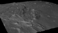
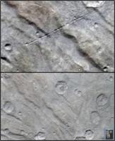
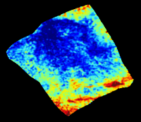
I have been experimenting with generating a DEM of Charon from a stereo pair. The resulting DEM is extremely crude and noisy, my software isn't very sophisticated and the JPG compression artifacts mess things up but at least I'm getting something that may be interesting. Here is a color coded DEM in simple cylindrical projection generated using images lor_0299175643_0x630_sci_4.jpg and lor_0299168728_0x630_sci_3.jpg together with an image showing the terrain convered by the DEM:
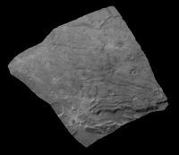
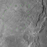
The are some errors due to the fact that I don't know the exact viewing geometry of the source images (the accuracy to which I could reverse engineer it is limited). The DEM is also noisy and low-res but it can be used to make crude estimates of relative elevation differences. For example the big crater at the left edge is probably 1-1.5 km deep. The depression/'canyon' at bottom and extending to the right edge is probably ~2.5 km deep but this is somewhat difficult to estimate due to noise in the DEM and the depth may also be variable. But what's really interesting is that the DEM reveals a possible gentle, large scale depression (the big blue area). I can't completely rule out that the southern edge of this feature could be an artifact caused by inaccurate viewing geometry but a more probable explanation is that this is a real feature. Here is one of the two images I used to make the DEM with the very approximate boundary of the possible depression indicated with green dots:
I think it should be possible to generate considerably better DEMs than this one, even when JPG source images are used. I have been looking for software (mainly free/open source stuff) to use instead of what I'm using now. I don't know yet what's going to come out of that but a lot has happened in this field since I originally wrote my (crude) stereo software several years ago. |
|||
|
|
|
|||
|
Oct 13 2015, 02:41 AM
Post
#77
|
||
|
Member Group: Members Posts: 890 Joined: 18-November 08 Member No.: 4489 |
for low frequency heights like that the sfs i use is mostly useless
it is good on hi-frequency data like the rift on the right for this stereo is needed then run the sfs from ASP on the Gtiff from stereo-pipline ( a hi-breed sfs with the stereo using the spice data ) this is what i get -- good for wrapping around a sphere mesh for 3d shading but--- has problems a 8 bit height map for " lor_0299175643_0x630_sci_4.jpg"
the lower half of the creator is ??? iffy maybe ??? some what visible in mine but that is only in a side by side with your green dots |
|
|
|
|
|
|
Oct 13 2015, 10:05 AM
Post
#78
|
||
|
Member Group: Members Posts: 796 Joined: 27-February 08 From: Heart of Europe Member No.: 4057 |
QUOTE (Bjorn Jonsson @ Oct 13 2015, 02:16 AM) But what's really interesting is that the DEM reveals a possible gentle, large scale depression (the big blue area). I can't completely rule out that the southern edge of this feature could be an artifact caused by inaccurate viewing geometry but a more probable explanation is that this is a real feature. I see major parts of your big blue area as depression but I think that circular shape is partly caused by artifacts. I think that central part (ridges) has different origin. My interpretation is that depressions are probably part of the same event which caused southern hemisphere resurfacing. Here is quick graphics which shows boundaries of different areas. Blue boundary is edge of resurfaced southern hemisphere. Green boundary is continuation of this resurfacing event through central chasmata system. Red boundary shows edges of another depressions (they are visible in your DEM) which could be another part of the same southern hemisphere resurfacing event.
Attached thumbnail(s)
-------------------- |
|
|
|
|
|
|
Oct 13 2015, 02:56 PM
Post
#79
|
|
|
Senior Member Group: Members Posts: 2998 Joined: 30-October 04 Member No.: 105 |
Agreed. The green-dotted depression is probably not a depression and, from the surface morphology, appears to be flatish or possibly a slightly positive elevation. It is probably a result of activity in the area of "Ripley" crater. There many changes with some resurfacing and it seems to occur in episodic events. More and more details pop out with increases in resolution-- this is going to be an interesting little world to figure out.
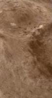
I'm looking forward to the Dawn team producing an elevation map. In the meantime, what are your feelings on the topography of "Mordor" macula? This feature does appear to be a depression, with the deepest rim being on the Pluto-side (left) and a shallower rim being on the anti-Pluto (right) side. I believe that feature will turn out to be the strangest of the strange on Charon. --Bill -------------------- |
|
|
|
|
Oct 13 2015, 06:01 PM
Post
#80
|
|||
|
Member Group: Members Posts: 866 Joined: 15-March 05 From: Santa Cruz, CA Member No.: 196 |
crosseye and parellel excerpt from Machi's stereo
yet another mystery wrapped in a connundrum, as if a cryovolcanic plug rose from one but why not the the other? although there is a minimountain just behind it. the fault line almost equidistant and perpendicular between the disparate moats mere coincidence?
|
||
|
|
|
||
|
Oct 16 2015, 05:23 PM
Post
#81
|
|
|
Member Group: Members Posts: 714 Joined: 3-January 08 Member No.: 3995 |
|
|
|
|
|
Oct 16 2015, 06:08 PM
Post
#82
|
||
 Senior Member Group: Moderator Posts: 3233 Joined: 11-February 04 From: Tucson, AZ Member No.: 23 |
Here's a quick mosaic of the C_MVIC_LORRI_CA images.
-------------------- &@^^!% Jim! I'm a geologist, not a physicist!
The Gish Bar Times - A Blog all about Jupiter's Moon Io |
|
|
|
|
|
|
Oct 16 2015, 08:04 PM
Post
#83
|
|
|
Member Group: Members Posts: 137 Joined: 16-June 15 Member No.: 7507 |
Okay, wow. If I only saw the right hand side of that I'd have thought it was Pluto! It's got the same sort of (what we've been presumling is sublimation pitting) that we see on Pluto - that's so neat! And it's not everywhere, either...
We also got the "three hills in a moat" terrain, our first closeup of one of the moats. Looks like a large chunk of the western side is slumping into it. A couple small areas also look to be slumped. The biggest moat there is polygonal - doesn't look like a crater at all. And there's some rather weird low-relief structures near its southern end and in the craters to the south - no idea what those might be. Kind of like something bubbled up there or something. |
|
|
|
|
Oct 16 2015, 08:51 PM
Post
#84
|
|
|
IMG to PNG GOD Group: Moderator Posts: 2251 Joined: 19-February 04 From: Near fire and ice Member No.: 38 |
QUOTE (Nafnlaus @ Oct 16 2015, 08:04 PM) Okay, wow. If I only saw the right hand side of that I'd have thought it was Pluto! It's got the same sort of (what we've been presumling is sublimation pitting) that we see on Pluto I'm sure I've seen very similar pitted terrain elsewhere (not including Pluto) and I'm trying to remember where. Probably on Mercury, the Moon or Mars. |
|
|
|
|
Oct 16 2015, 08:56 PM
Post
#85
|
|||
|
Member Group: Members Posts: 244 Joined: 2-March 15 Member No.: 7408 |
Extreme stereo view on Charon.
Parallel viewing:
Cross-Eye viewing:
|
||
|
|
|
||
|
Oct 16 2015, 09:59 PM
Post
#86
|
|
|
Senior Member Group: Members Posts: 3516 Joined: 4-November 05 From: North Wales Member No.: 542 |
I'm intrigued by the dark-splat-in-the-middle-of-a-bright-splat in this image. (It appears at the edge of Herobrine's 3D view above.) The dark splat is presumably more recent than the larger bright one. I think it unlikely that very differently toned materials were thrown out by the two events, so I come round to the idea that ejecta change colour with time in a non-monotonic way. They are dark at first before bleaching out, and only then dull down again to match the general tone of the surroundings. Any thoughts?
http://pluto.jhuapl.edu/soc/Pluto-Encounte...0x630_sci_4.jpg |
|
|
|
|
Oct 16 2015, 10:29 PM
Post
#87
|
|
|
Senior Member Group: Moderator Posts: 3233 Joined: 11-February 04 From: Tucson, AZ Member No.: 23 |
It could also be due to layering in the near-surface of Charon. IIRC the more distal, bright rays should come from material that was near the surface while the closer dark ones would result from ejects that originated at greater depths.
-------------------- &@^^!% Jim! I'm a geologist, not a physicist!
The Gish Bar Times - A Blog all about Jupiter's Moon Io |
|
|
|
|
Oct 16 2015, 10:56 PM
Post
#88
|
|
|
Senior Member Group: Members Posts: 3516 Joined: 4-November 05 From: North Wales Member No.: 542 |
Interesting, but I find it hard to believe that the bigger impact missed the dirt but the later smaller one found it.
Or are you saying that it was all exposed at once, with dark and light ejecta zones mapping the subsurface layers? |
|
|
|
|
Oct 17 2015, 12:04 AM
Post
#89
|
|
|
Member Group: Members Posts: 890 Joined: 18-November 08 Member No.: 4489 |
a few 3d renders from
http://pluto.jhuapl.edu/soc/Pluto-Encounter/index.php lor_0299180418_0x630_sci_3.jpg lor_0299180415_0x630_sci_4.jpg ---------- joined the two then created a heightmap from that 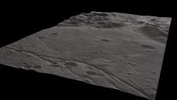 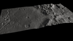 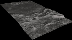 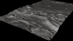 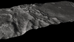  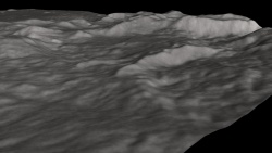
|
|
|
|
|
Oct 17 2015, 03:35 AM
Post
#90
|
|
 Member Group: Members Posts: 146 Joined: 22-November 14 From: Bormida (SV) - Italy Member No.: 7348 |
Here the last mosaics
  EDIT anaglyph 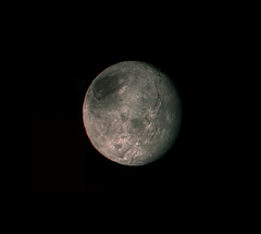
-------------------- |
|
|
|
|
Oct 17 2015, 06:42 PM
Post
#91
|
|
|
Member Group: Members Posts: 890 Joined: 18-November 08 Member No.: 4489 |
mosaic and crop of:
lor_0299180421_0x630_sci_3.jpg lor_0299180424_0x630_sci_3.jpg ----- the partially sunken mountain 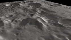 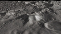 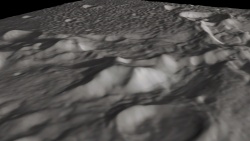 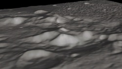 |
|
|
|
|
Oct 19 2015, 08:03 PM
Post
#92
|
|
 Member Group: Members Posts: 684 Joined: 24-July 15 Member No.: 7619 |
Here's an interesting bit of info, from our own (sorta) double planet,
Earth's tidal effects on the moon seem to determine the large scale orientation of lunar faults and scarps that result from cooling.  http://geology.gsapubs.org/content/43/10/851.full So, it is reasonable to surmise that cracks visible on Charon's crust now were influenced by Charons' rotation relative to Pluto in the past.... |
|
|
|
| Guest_MichaelPoole_* |
Oct 30 2015, 03:19 PM
Post
#93
|
|
Guests |
A probably young, ammonia rich crater has been found on Charon:
http://pluto.jhuapl.edu/News-Center/News-A...?page=20151029b |
|
|
|
|
Oct 30 2015, 11:48 PM
Post
#94
|
||
|
Solar System Cartographer Group: Members Posts: 10164 Joined: 5-April 05 From: Canada Member No.: 227 |
We really need the PDS versions of the night-side images to do anything useful, but you have to wonder if anything will show up.
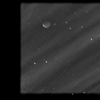
So here is a truly horrible image. It is a stack of ten of the early Pluto-shine images of Charon. They were averaged, then the average was subtracted from each frame separately, the bland result was stretched to a ridiculous degree, and the ten resulting frames were averaged again and merged into one layer. Does it show anything? Probably not. But I still hold out hope for the raw data! Phil
-------------------- ... because the Solar System ain't gonna map itself.
Also to be found posting similar content on https://mastodon.social/@PhilStooke Maps for download (free PD: https://upload.wikimedia.org/wikipedia/comm...Cartography.pdf NOTE: everything created by me which I post on UMSF is considered to be in the public domain (NOT CC, public domain) |
|
|
|
|
|
|
Oct 31 2015, 12:57 AM
Post
#95
|
|
|
Member Group: Members Posts: 890 Joined: 18-November 08 Member No.: 4489 |
Phil it is better than i expected
|
|
|
|
|
Oct 31 2015, 01:10 AM
Post
#96
|
|||
|
Member Group: Members Posts: 796 Joined: 27-February 08 From: Heart of Europe Member No.: 4057 |
It's a pity that most Charon's images are binned so resolution is very low.
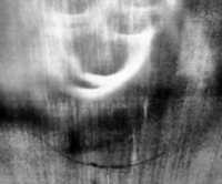
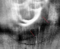
But is there something in the Plutoshine? It is! Dark side of the Charon! EDIT: I added 4× enlarged 90° rotated version after slightly better processing.
Attached thumbnail(s)
-------------------- |
||
|
|
|
||
|
Oct 31 2015, 01:37 AM
Post
#97
|
|||
 Member Group: Members Posts: 555 Joined: 27-September 10 Member No.: 5458 |
Best I could do in pulling anything out in a short time.
Lower right half, looks like there could be a few craters popping through. Could just be noise.
@Machi: Looks really great! -------------------- |
||
|
|
|
||
|
Oct 31 2015, 01:47 AM
Post
#98
|
|
|
Solar System Cartographer Group: Members Posts: 10164 Joined: 5-April 05 From: Canada Member No.: 227 |
"Phil it is better than i expected"
Actually, I just realized my strategy is removing the signal as well as the noise! What I did works properly with images like Clementine Long Wavelength Infrared, where the noise and hot pixels etc. are the same and can be subtracted, but the signal is different in each image. Here I am throwing the baby out with the bathwater, so to speak. Hmmm... need another strategy. Phil PS Machi - fantastic! -------------------- ... because the Solar System ain't gonna map itself.
Also to be found posting similar content on https://mastodon.social/@PhilStooke Maps for download (free PD: https://upload.wikimedia.org/wikipedia/comm...Cartography.pdf NOTE: everything created by me which I post on UMSF is considered to be in the public domain (NOT CC, public domain) |
|
|
|
|
Oct 31 2015, 04:54 AM
Post
#99
|
|
|
Senior Member Group: Members Posts: 2998 Joined: 30-October 04 Member No.: 105 |
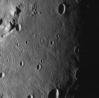
OTOH, I decided ot work with images that weren't already DOA. Here is a montage of the LORRI image set released a couple of weeks ago. Shows the "northern highland" and "southern plain" from a very different perspective than the near-encounter image sets we first saw.
The recently found "ammonia crater" ("Organa crater") is in the upper-left, partially obscured in a depression and the related "non-ammonia crater ("Skywalker crater") is just below center on the left, both near the limb. "Alice crater" is the large hummocky-floored crater in the "northern highland" and "Kirk crater" and "Clarke mons" are the features on the floor of the "southern plain" https://univ.smugmug.com/New-Horizons-Missi...pano--annot.jpg --Bill -------------------- |
|
|
|
|
Oct 31 2015, 04:02 PM
Post
#100
|
|
|
Senior Member Group: Members Posts: 4247 Joined: 17-January 05 Member No.: 152 |
Machi: that is very nice - did you use all available frames for the 4x view?
ZLD - don't those frames show Pluto, not Charon? |
|
|
|
|

|
Lo-Fi Version | Time is now: 19th May 2024 - 06:46 PM |
|
RULES AND GUIDELINES Please read the Forum Rules and Guidelines before posting. IMAGE COPYRIGHT |
OPINIONS AND MODERATION Opinions expressed on UnmannedSpaceflight.com are those of the individual posters and do not necessarily reflect the opinions of UnmannedSpaceflight.com or The Planetary Society. The all-volunteer UnmannedSpaceflight.com moderation team is wholly independent of The Planetary Society. The Planetary Society has no influence over decisions made by the UnmannedSpaceflight.com moderators. |
SUPPORT THE FORUM Unmannedspaceflight.com is funded by the Planetary Society. Please consider supporting our work and many other projects by donating to the Society or becoming a member. |
|