HiRISE and Mars Polar Lander |

  |
HiRISE and Mars Polar Lander |
| Guest_Sunspot_* |
 Dec 6 2006, 02:05 PM Dec 6 2006, 02:05 PM
Post
#1
|
|
Guests |
Looking at the images of the Spirit/Opportunity landing site, it seems many of the features such as tracks and rocket blast markings have faded considerably often to the point of being invisible in the nearly three years since landing.
This had me thinking about the MGS images taken in the hope of finding MPL. Initially it was reported that MGS had spotted the lander, one image had a white spot/streak interpreted as the parachute and a dark patch with a spot in the centre not too far off, taken to be the blast zone of the rockets with the lander in the centre. However another image taken 5 years later seemed to discount this theory - the features had faded or changed significantly. BUT, seeing how much the rover sites have changed in an even shorter time, wouldn't the same happen to the MPL site in 5 years - perhaps to an even greater degree with the more extreme seasonal changes at that location. Also, the latest HiRISE images show just how difficult it has been to spot the landers on the surface with MGS, the Viking sites in particular. I hope HiRISE takes another look at this spot. Mars Polar Lander NOT Found, MSSS article: http://www.msss.com/mars_images/moc/2005/10/17/ |
 |
 
|
| Guest_Zvezdichko_* |
Dec 13 2007, 09:59 AM
Post
#2
|
|
Guests |
Digging up this thread. The Sun has returned to the south pole so maybe it's time to search for the Mars Polar Lander.
I wonder how climate changes described in an article yesterday have affected the hardware of MPL. |
|
|
|
|
Dec 13 2007, 04:55 PM
Post
#3
|
|
 Administrator  Group: Admin Posts: 5172 Joined: 4-August 05 From: Pasadena, CA, USA, Earth Member No.: 454 |
I think it's a good idea to collect links to HiRISE images that cross the MPL landing ellipse. For starters, here are the MOC pages that describe the search and show the search region:
http://www.msss.com/mars_images/moc/12_99_...arch/index.html http://www.msss.com/mars_images/moc/1_24_0...nder/index.html http://www.msss.com/mars_images/moc/oct_20...site/index.html These images unfortunately do not include any latitude/longitude information. However, here's a page from the MOLA team that does, suggesting that a useful box to consider is 75 to 77 south and 164 to 166 east. http://ssed.gsfc.nasa.gov/tharsis/mpl.html --Emily -------------------- My website - My Patreon - @elakdawalla on Twitter - Please support unmannedspaceflight.com by donating here.
|
|
|
|
|
Dec 13 2007, 11:52 PM
Post
#4
|
|
|
Member Group: Admin Posts: 468 Joined: 11-February 04 From: USA Member No.: 21 |
QUOTE (elakdawalla @ Dec 13 2007, 08:55 AM)  ...a useful box to consider is 75 to 77 south and 164 to 166 east. So far, it looks like there are at least 3 images inside that box: http://hirise.lpl.arizona.edu/PSP_002846_1040 color bands available (and a little whoops in the label..."Possible Phoenix Lander Landing Site"?) http://hirise.lpl.arizona.edu/PSP_003690_1035 red filter http://hirise.lpl.arizona.edu/PSP_004336_1035 red filter, heavily clouded over |
|
|
|
| Guest_Charles_* |
Feb 7 2008, 08:29 PM
Post
#5
|
|
Guests |
I am wondering if the MPL (Mars Polar Lander) did not crash but sank into the the ice. I read as one of the possible causes was that the landing sensor thought it landed.
Just my small thought. |
|
|
|
| Guest_Zvezdichko_* |
May 11 2008, 09:24 AM
Post
#6
|
|
Guests |
Help them find Mars Polar Lander!
article written by Mr. Phil Plait : http://www.badastronomy.com/bablog/2008/05...s-polar-lander/ and the publication on HiRISE website: http://hirise.lpl.arizona.edu/HiBlog/?p=134 Regards, Svetlio |
|
|
|
| Guest_Sunspot_* |
May 12 2008, 10:45 AM
Post
#7
|
|
Guests |
I do find it odd that absolutely no trace of Mars Polar Lander has been spotted within HiRISE images so far. If the failure scenario proposed by the investigation team is correct, the parachute deployed successfully, the heatshield was jettisoned and the lander separated from the backshell. All of those components are VERY striking in images of the MER landing sites, in fact you can see them without having to view the images at a "one to one" scale, you certainly didn't need to search for them.
How would several Martian polar winters have affected those components visibility, would they "weather " differently to those at lower latitudes such as Spirit and Opportunity, is that the reason they haven't been spotted I wonder? I suppose it's also possible that something else went wrong during EDL - the parachute failed to deploy for example. |
|
|
|
|
May 12 2008, 11:01 AM
Post
#8
|
|
|
Solar System Cartographer Group: Members Posts: 10229 Joined: 5-April 05 From: Canada Member No.: 227 |
Yesss... but we knew where those sites were! The descent images brought us very close, and the surface images clinched it. Here, we have no clue where to look across those vast images. Well, a clue, the target ellipses. But there's a lot of territory to search.
Phil -------------------- ... because the Solar System ain't gonna map itself.
Also to be found posting similar content on https://mastodon.social/@PhilStooke Maps for download (free PDF: https://upload.wikimedia.org/wikipedia/comm...Cartography.pdf NOTE: everything created by me which I post on UMSF is considered to be in the public domain (NOT CC, public domain) |
|
|
|
|
May 12 2008, 11:02 AM
Post
#9
|
|
 Senior Member Group: Members Posts: 3648 Joined: 1-October 05 From: Croatia Member No.: 523 |
QUOTE (Sunspot @ May 12 2008, 12:45 PM) I do find it odd that absolutely no trace of Mars Polar Lander has been spotted within HiRISE images so far. Has the entire landing ellipse even been covered by HiRise? If the image on the blog linked to above is anything to go by, about 2/3 of the landing ellipse is covered to this date. It's possible they looked at the "wrong" places to find it or it's possible it's there, but lost in some of that terrain - from what I've seen it's not exactly featureless in that MPL would jump out right at you. -------------------- |
|
|
|
|
May 12 2008, 11:14 AM
Post
#10
|
|
|
Founder Group: Chairman Posts: 14434 Joined: 8-February 04 Member No.: 1 |
It's parachute would.
|
|
|
|
| Guest_Sunspot_* |
May 12 2008, 12:08 PM
Post
#11
|
|
|
Guests |
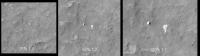
QUOTE (Phil Stooke @ May 12 2008, 12:01 PM) Yesss... but we knew where those sites were! The descent images brought us very close, and the surface images clinched it. Here, we have no clue where to look across those vast images. Well, a clue, the target ellipses. But there's a lot of territory to search. Phil Yes... but the point I was trying to make is that it wouldnt have taken long, "seconds" probably to identify the various components in the MER landing site images, even without images from the rovers on the ground. The parachutes are visible when the images are viewed at 25% scale, at 100% you can see the folds in them!!! It seems like we will need to search the MPL site at the single pixel scale. Spirit's parachute and Backshell are shown below at various scales.
Attached thumbnail(s)
|
|
|
|
|
|
| Guest_Zvezdichko_* |
May 12 2008, 12:57 PM
Post
#12
|
|
Guests |
Also, if you are unable to view the big jp2 images, you may start a quick search using the grayscale .jpg images. Rover tracks are visible, so you may be even able to spot the rocket blast zone of MPL.
|
|
|
|
|
May 12 2008, 01:23 PM
Post
#13
|
|
|
Solar System Cartographer Group: Members Posts: 10229 Joined: 5-April 05 From: Canada Member No.: 227 |
It's only easy if you know what you're looking for, and where to look. We know nothing about the state of the vehicle - I'm not sure we even know if the DS2 probes were deployed, though I might be wrong about that, not having looked it up. And we don't know where to look.
But put that aside... can anybody identify in HiRISE the feature initially interpreted as MPL in MOC images? I've only glanced, but not found it yet. Phil -------------------- ... because the Solar System ain't gonna map itself.
Also to be found posting similar content on https://mastodon.social/@PhilStooke Maps for download (free PDF: https://upload.wikimedia.org/wikipedia/comm...Cartography.pdf NOTE: everything created by me which I post on UMSF is considered to be in the public domain (NOT CC, public domain) |
|
|
|
| Guest_Sunspot_* |
May 12 2008, 04:54 PM
Post
#14
|
|
Guests |
QUOTE (Phil Stooke @ May 12 2008, 02:23 PM) It's only easy if you know what you're looking for, and where to look. We know nothing about the state of the vehicle Phil But if the failure scenario favoured by the investigation team is correct, the lander probably made it to the surface in one piece with the rest of the EDL hardware in the surrounding area. |
|
|
|
|
May 12 2008, 07:19 PM
Post
#15
|
|
|
Solar System Cartographer Group: Members Posts: 10229 Joined: 5-April 05 From: Canada Member No.: 227 |
That's true! But we don't know that's what happened, and one explanation for the difficulty in finding it would be...
Phil -------------------- ... because the Solar System ain't gonna map itself.
Also to be found posting similar content on https://mastodon.social/@PhilStooke Maps for download (free PDF: https://upload.wikimedia.org/wikipedia/comm...Cartography.pdf NOTE: everything created by me which I post on UMSF is considered to be in the public domain (NOT CC, public domain) |
|
|
|
|

|
Lo-Fi Version | Time is now: 27th September 2024 - 06:10 AM |
|
RULES AND GUIDELINES Please read the Forum Rules and Guidelines before posting. IMAGE COPYRIGHT |
OPINIONS AND MODERATION Opinions expressed on UnmannedSpaceflight.com are those of the individual posters and do not necessarily reflect the opinions of UnmannedSpaceflight.com or The Planetary Society. The all-volunteer UnmannedSpaceflight.com moderation team is wholly independent of The Planetary Society. The Planetary Society has no influence over decisions made by the UnmannedSpaceflight.com moderators. |
SUPPORT THE FORUM Unmannedspaceflight.com is funded by the Planetary Society. Please consider supporting our work and many other projects by donating to the Society or becoming a member. |
|