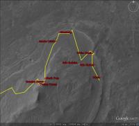
East side of Cape York, Sol 3040 - 3056 |

  |
East side of Cape York, Sol 3040 - 3056 |
 Aug 12 2012, 09:57 PM Aug 12 2012, 09:57 PM
Post
#1
|
||
|
Senior Member  Group: Moderator Posts: 4279 Joined: 19-April 05 From: .br at .es Member No.: 253 |
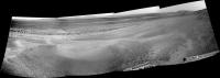
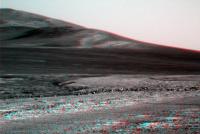
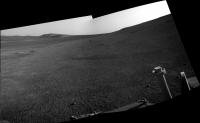
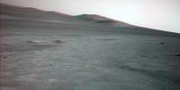
Well, my impression is that the trek south, crossing by the east side of Cape York, has started.
Here's a crude navcam mosaic taken on sol 3040. Don't you think this side of the planet is also beautiful?
|
|
 |
 
|
|
|
Aug 12 2012, 10:01 PM
Post
#2
|
|
|
Solar System Cartographer Group: Members Posts: 10164 Joined: 5-April 05 From: Canada Member No.: 227 |
That looks like the next little crater south of the Creek.
Phil -------------------- ... because the Solar System ain't gonna map itself.
Also to be found posting similar content on https://mastodon.social/@PhilStooke Maps for download (free PD: https://upload.wikimedia.org/wikipedia/comm...Cartography.pdf NOTE: everything created by me which I post on UMSF is considered to be in the public domain (NOT CC, public domain) |
|
|
|
|
Aug 12 2012, 10:06 PM
Post
#3
|
|
|
Senior Member Group: Moderator Posts: 4279 Joined: 19-April 05 From: .br at .es Member No.: 253 |
Exactly!
|
|
|
|
|
Aug 13 2012, 12:45 PM
Post
#4
|
|
|
Senior Member Group: Members Posts: 2920 Joined: 14-February 06 From: Very close to the Pyrénées Mountains (France) Member No.: 682 |
We're about 800m or half a mile (as Oppy flies) to Botany Bay.
-------------------- |
|
|
|
|
Aug 13 2012, 12:51 PM
Post
#5
|
||
|
Senior Member Group: Moderator Posts: 4279 Joined: 19-April 05 From: .br at .es Member No.: 253 |
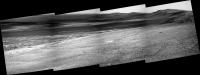
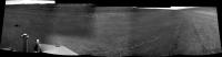
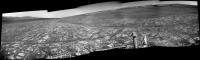
Here's the "drive direction" pancam mosaic from sol 3040. Path clear.
|
|
|
|
|
|
|
Aug 13 2012, 12:56 PM
Post
#6
|
|
 Member Group: Members Posts: 813 Joined: 8-February 04 From: Arabia Terra Member No.: 12 |
Cape York seems somehow... diminished. The flashiness of Gale has spoilt me for other parts of Mars!

|
|
|
|
|
Aug 13 2012, 01:32 PM
Post
#7
|
|
|
Senior Member Group: Members Posts: 2920 Joined: 14-February 06 From: Very close to the Pyrénées Mountains (France) Member No.: 682 |
Re drive direction. I don't know if they are little cliffs or just rocks but some interesting features can be already seens ahead.
-------------------- |
|
|
|
|
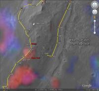
Aug 13 2012, 02:17 PM
Post
#8
|
|
|
Forum Contributor Group: Members Posts: 1372 Joined: 8-February 04 From: North East Florida, USA. Member No.: 11 |
QUOTE (SFJCody @ Aug 13 2012, 12:56 PM)  Cape York seems somehow... diminished. The flashiness of Gale has spoilt me for other parts of Mars! One of the reasons Gale was choosen, and I am sure it was a pretty low down on the list reason...., was the shear spectacular scenery Joe Public could get excited about at Gale. Still Endeavour is nice and when we climb up a bit it will get better. |
|
|
|
|
Aug 13 2012, 06:19 PM
Post
#9
|
|
 The Poet Dude Group: Moderator Posts: 5551 Joined: 15-March 04 From: Kendal, Cumbria, UK Member No.: 60 |
QUOTE (SFJCody @ Aug 13 2012, 01:56 PM) Cape York seems somehow... diminished. The flashiness of Gale has spoilt me for other parts of Mars! 'Diminished'? Hmmm. Tempting maybe to feel that way when we're suddenly faced with a jagged and undulating horizon curving around us, and a towering mountain looming right ahead of us, compared to the gentler hills and slopes of Endeavour. But if you catch yourself feeling that way just remember what Oppy went through to get here. Remember the trials and tribulations she overcame to reach this place. Remember her Lewis and Clark trek across Meridiani, driving from crater to crater, increasingly thick with dust. Then think of the months ahead for Oppy - driving down the flank of Cape York, then rolling off the Cape and across Botany Bay to the foot of Cape Tribulation, and then up...and up... until she's looking down on Endeavour, the crater she was never meant to reach. Then, trust me, the magic of Endeavour will return to you...  -------------------- |
|
|
|
|
Aug 13 2012, 06:25 PM
Post
#10
|
|
 Senior Member Group: Members Posts: 2228 Joined: 1-December 04 From: Marble Falls, Texas, USA Member No.: 116 |
Then too, Opportunity has a fair chance to spot clay minerals before Curiosity.

-------------------- ...Tom
I'm not a Space Fan, I'm a Space Exploration Enthusiast. |
|
|
|
|
Aug 13 2012, 06:26 PM
Post
#11
|
|
|
Senior Member Group: Members Posts: 1583 Joined: 14-October 05 From: Vermont Member No.: 530 |
^ Yeah! I actually didn't think "diminished" so much as, "It's awesome that we're seeing these two fantastic crater vistas at the same time."
|
|
|
|
|
Aug 13 2012, 10:06 PM
Post
#12
|
|
|
Member Group: Members Posts: 813 Joined: 8-February 04 From: Arabia Terra Member No.: 12 |
QUOTE (Stu @ Aug 14 2012, 04:19 AM) Then, trust me, the magic of Endeavour will return to you... Just a little humour really. Endeavour still has its not inconsiderable charms. I remain rightly astonished that a machine that all good sense told us would spend a few months trundling around around a sports stadium sized patch of one of the flattest places on Mars is now completely outside its landing ellipse and chasing clay minerals in the rim of a 20km crater with more hilliness than her EDL system was deemed suitable for. Long may whichever Martian deities smile on her continue to do so! |
|
|
|
|
Aug 14 2012, 02:04 AM
Post
#13
|
|
 Senior Member Group: Members Posts: 4247 Joined: 17-January 05 Member No.: 152 |
And that's a monster-sized MER landing ellipse, not one of those tiny MSL ones!
 I love this parting shot of the creek: http://qt.exploratorium.edu/mars/opportuni...0M1.JPG?sol3041 |
|
|
|
|
Aug 14 2012, 02:20 AM
Post
#14
|
|
 Newbie Group: Members Posts: 8 Joined: 21-April 12 Member No.: 6382 |
The recent drives seem to really bring out the crater rim. Seems a bit more distinctive then recent Pancam shots. Would be interesting to see the color composites from 3040+ of the area.
-------------------- |
|
|
|
|
Aug 14 2012, 07:52 PM
Post
#15
|
|||
|
Member Group: Members Posts: 178 Joined: 13-September 05 Member No.: 498 |
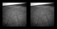
QUOTE (fredk @ Aug 13 2012, 07:04 PM) I love this parting shot of the creek: http://qt.exploratorium.edu/mars/opportuni...0M1.JPG?sol3041 That's a good one. Here's a x-eye view...
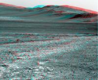
and here's one across the crater to show that Endeavour can stand comparison with Gale...
|
||
|
|
|
||
|
Aug 14 2012, 10:41 PM
Post
#16
|
|
|
Senior Member Group: Members Posts: 4247 Joined: 17-January 05 Member No.: 152 |
It looks like a drive SSE to the next little crater on 3042:
http://qt.exploratorium.edu/mars/opportuni...0M1.JPG?sol3042 |
|
|
|
|
Aug 14 2012, 11:39 PM
Post
#17
|
|
|
Solar System Cartographer Group: Members Posts: 10164 Joined: 5-April 05 From: Canada Member No.: 227 |
That's a nice one... do we have names for these two craters yet?
Phil -------------------- ... because the Solar System ain't gonna map itself.
Also to be found posting similar content on https://mastodon.social/@PhilStooke Maps for download (free PD: https://upload.wikimedia.org/wikipedia/comm...Cartography.pdf NOTE: everything created by me which I post on UMSF is considered to be in the public domain (NOT CC, public domain) |
|
|
|
|
Aug 15 2012, 08:25 AM
Post
#18
|
|
|
Senior Member Group: Moderator Posts: 4279 Joined: 19-April 05 From: .br at .es Member No.: 253 |
The one spot on sol 3040 was named "São Rafael". This last one just N of the current site has no name yet on the DB.
|
|
|
|
|
Aug 16 2012, 12:07 AM
Post
#19
|
|
|
Senior Member Group: Members Posts: 4247 Joined: 17-January 05 Member No.: 152 |
Our first look at the east-facing outcrops on the inboard side of CY:
http://qt.exploratorium.edu/mars/opportuni...6M1.JPG?sol3043 These are the kind of outcrops where the clays will hopefully be found, though probably farther south. |
|
|
|
|
Aug 16 2012, 02:39 AM
Post
#20
|
|
|
Member Group: Admin Posts: 976 Joined: 29-September 06 From: Pasadena, CA - USA Member No.: 1200 |
QUOTE (fredk @ Aug 15 2012, 05:07 PM) Our first look at the east-facing outcrops on the inboard side of CY: http://qt.exploratorium.edu/mars/opportuni...6M1.JPG?sol3043 These are the kind of outcrops where the clays will hopefully be found, though probably farther south. Darn it, now that the scenery begins to look interesting I'm on the side of the planet that looks a pancake! :-( Paolo -------------------- Disclaimer: all opinions, ideas and information included here are my own,and should not be intended to represent opinion or policy of my employer.
|
|
|
|
|
Aug 16 2012, 04:29 AM
Post
#21
|
||
 Member Group: Members Posts: 404 Joined: 5-January 10 Member No.: 5161 |
A bit more of a drop off than I expected. And that ever-shining beacon of a rock outcrop on the distant mountain!
|
|
|
|
|
|
|
Aug 16 2012, 08:28 AM
Post
#22
|
||
|
Senior Member Group: Moderator Posts: 4279 Joined: 19-April 05 From: .br at .es Member No.: 253 |
Some more info about the craters in the vicinity. This last one, seen on sol 3042, was named "Bérrio" so now it's clear that São Gabriel, São Rafael, and Bérrio were named after the ships of Vasco da Gama's armada on his first voyage to India.
|
|
|
|
|
|
|
Aug 16 2012, 02:34 PM
Post
#23
|
||
|
Senior Member Group: Members Posts: 4247 Joined: 17-January 05 Member No.: 152 |
QUOTE (walfy @ Aug 16 2012, 05:29 AM) A bit more of a drop off than I expected. Agreed. And dead centre in your anaglyph we can see what looks like another mini Whim Creek feature - a "notch" aligned roughly along the circumference of Endeavour:
If you use your imagination, you can find other similar features farther south. |
|
|
|
|
|
|
Aug 16 2012, 04:37 PM
Post
#24
|
|
|
Member Group: Members Posts: 362 Joined: 13-April 06 From: Malta Member No.: 741 |
I recall from CRISM data that there should be phyllosilicates somewhere along the eastern rim of Cape York. How far would Opportunity be from this point in reaching such rocks? Anyone has any idea?
|
|
|
|
|
Aug 16 2012, 05:10 PM
Post
#25
|
|
|
Senior Member Group: Members Posts: 4247 Joined: 17-January 05 Member No.: 152 |
The crism data is pretty low resolution, so the estimates I've heard are very roughly half way down CY.
|
|
|
|
|
Aug 16 2012, 05:22 PM
Post
#26
|
|
|
Member Group: Members Posts: 362 Joined: 13-April 06 From: Malta Member No.: 741 |
QUOTE (fredk @ Aug 16 2012, 06:10 PM) The crism data is pretty low resolution, so the estimates I've heard are very roughly half way down CY. a couple hundred metres away? |
|
|
|
|
Aug 16 2012, 05:26 PM
Post
#27
|
||
|
The Poet Dude Group: Moderator Posts: 5551 Joined: 15-March 04 From: Kendal, Cumbria, UK Member No.: 60 |
Colour view of the east-facing outcrops...
Go get 'em Oppy...
-------------------- |
|
|
|
|
|
|
Aug 16 2012, 09:07 PM
Post
#28
|
|
 Member Group: Members Posts: 754 Joined: 9-February 07 Member No.: 1700 |
Wow, it's going to get very interesting if Curiosity examines rocks from those time periods while Oppy is looking at equivalent examples a great distance away.
|
|
|
|
|
Aug 16 2012, 11:24 PM
Post
#29
|
|
|
Member Group: Members Posts: 507 Joined: 10-September 08 Member No.: 4338 |
QUOTE (Julius @ Aug 16 2012, 09:22 AM) a couple hundred metres away? It might be that we have already reached outcrops with some phyllosilicates, but the signatures are too weak to be detected by CRISM. The outcrop in view now seems to bear some similarity to those further down. |
|
|
|
|
Aug 17 2012, 02:50 AM
Post
#30
|
||
|
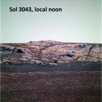
Member Group: Members Posts: 808 Joined: 10-October 06 From: Maynard Mass USA Member No.: 1241 |
Here are some rocky outcrops on Cape York (Sol 3043) as Oppy and JPL continue the exploration southward at Endevour Crater. The dusty red draped rocks are very inviting...
... In the lower center, is that a gypsum precipitate ? -------------------- CLA CLL
|
|
|
|
|
|
|
Aug 17 2012, 05:32 AM
Post
#31
|
|
|
Senior Member Group: Members Posts: 2998 Joined: 30-October 04 Member No.: 105 |
That would be my guess, too. I've seen a couple of gypsum veins on this leg of the traverse.
Interesting outcrop area. --Bill -------------------- |
|
|
|
|
Aug 17 2012, 05:18 PM
Post
#32
|
||
|
Senior Member Group: Members Posts: 4247 Joined: 17-January 05 Member No.: 152 |
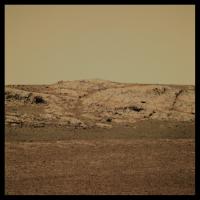
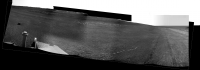
The east side of CY is turning out to be very scenic:
|
|
|
|
|
|
|
Aug 17 2012, 11:10 PM
Post
#33
|
|
|
Member Group: Admin Posts: 976 Joined: 29-September 06 From: Pasadena, CA - USA Member No.: 1200 |
QUOTE (Stu @ Aug 16 2012, 10:26 AM) Colour view of the east-facing outcrops... .... Go get 'em Oppy... Stu SS and I just spend a good 10 minutes in awe at this image. Really cool! Paolo -------------------- Disclaimer: all opinions, ideas and information included here are my own,and should not be intended to represent opinion or policy of my employer.
|
|
|
|
|
Aug 17 2012, 11:43 PM
Post
#34
|
|
|
The Poet Dude Group: Moderator Posts: 5551 Joined: 15-March 04 From: Kendal, Cumbria, UK Member No.: 60 |
Wow, thanks Paolo, great to know that!
-------------------- |
|
|
|
|
Aug 18 2012, 02:10 PM
Post
#35
|
|
 Member Group: Members Posts: 495 Joined: 12-February 12 Member No.: 6336 |
I'd say thank you for those images also. I do appreciate your work guys!
|
|
|
|
|
Aug 19 2012, 04:37 AM
Post
#36
|
|
|
Senior Member Group: Members Posts: 4247 Joined: 17-January 05 Member No.: 152 |
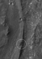
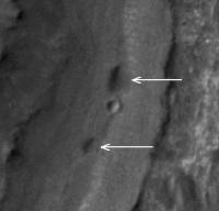
Maybe a meteorite?
http://qt.exploratorium.edu/mars/opportuni...0M1.JPG?sol3046 It's been a while since we've encountered one. |
|
|
|
|
Aug 19 2012, 04:49 AM
Post
#37
|
|
|
Merciless Robot Group: Admin Posts: 8784 Joined: 8-December 05 From: Los Angeles Member No.: 602 |
Maybe. Could be a whole lot of other more mundane things, though. Wonder if they'll think it's worth a stop.
-------------------- A few will take this knowledge and use this power of a dream realized as a force for change, an impetus for further discovery to make less ancient dreams real.
|
|
|
|
|
Aug 19 2012, 09:05 AM
Post
#38
|
|
|
Senior Member Group: Members Posts: 2920 Joined: 14-February 06 From: Very close to the Pyrénées Mountains (France) Member No.: 682 |
QUOTE (fredk @ Aug 19 2012, 06:37 AM) Maybe a meteorite? http://qt.exploratorium.edu/mars/opportuni...0M1.JPG?sol3046 It's been a while since we've encountered one. Hide it, quick, quick, before Stu notice it Anyway, looking at Eduardo's map, it seams we already passed the outcrop area. Doesn't mean we cannot get back there since SS and Paolo... -------------------- |
|
|
|
|
Aug 19 2012, 09:41 AM
Post
#39
|
|
|
The Poet Dude Group: Moderator Posts: 5551 Joined: 15-March 04 From: Kendal, Cumbria, UK Member No.: 60 |
QUOTE (climber @ Aug 19 2012, 10:05 AM) Hide it, quick, quick, before Stu notice it Too late, already seen it and already planning to add it to the "Meteorites of Meridiani" collection over at the Road to Endeavour Meteorite Museum! -------------------- |
|
|
|
|
Aug 19 2012, 09:44 AM
Post
#40
|
|
|
Senior Member Group: Moderator Posts: 4279 Joined: 19-April 05 From: .br at .es Member No.: 253 |
QUOTE (climber @ Aug 19 2012, 11:05 AM) ... it seams we already passed the outcrop area. Not really. That picture is from a new position (yesterday's drive) which is not yet on the map. Tactical decisions about what to do next will not be taken until tomorrow. |
|
|
|
|
Aug 19 2012, 05:10 PM
Post
#41
|
||
|
Senior Member Group: Moderator Posts: 4279 Joined: 19-April 05 From: .br at .es Member No.: 253 |
QUOTE (fredk @ Aug 19 2012, 06:37 AM) Maybe a meteorite? http://qt.exploratorium.edu/mars/opportuni...0M1.JPG?sol3046 It's been a while since we've encountered one. Here's the navcam mosaic of this nice site. A meteorite(?) ahead and a gypsum vein just behind.
BTW, this was a loooong 100m drive! |
|
|
|
|
|
|
Aug 19 2012, 07:44 PM
Post
#42
|
|
|
Member Group: Admin Posts: 976 Joined: 29-September 06 From: Pasadena, CA - USA Member No.: 1200 |
QUOTE (Tesheiner @ Aug 19 2012, 10:10 AM) ... BTW, this was a loooong 100m drive! SS was SOWG chair on Friday. I wonder if this has anything to do with it  Paolo -------------------- Disclaimer: all opinions, ideas and information included here are my own,and should not be intended to represent opinion or policy of my employer.
|
|
|
|
|
Aug 19 2012, 08:41 PM
Post
#43
|
||
|
Member Group: Members Posts: 194 Joined: 3-January 10 Member No.: 5156 |
Added a little more drama by rotating Tesheiners by 6.5 degrees, so that the far horizon is flat. I think Oppy is driving on the steep slope of Cape York, so this view may give a hint how it is feeling to stand there.
EDIT: Why does this meteorite not roll down?
Attached thumbnail(s)
-------------------- Need more input ...
|
|
|
|
|
|
|
Aug 20 2012, 12:26 PM
Post
#44
|
|
|
Member Group: Members Posts: 252 Joined: 27-April 05 Member No.: 365 |
Article on Opportunity, including pic of Ashley Stroupe planning a drive.
Curiosity is new Mars star, but Opportunity's still knocking |
|
|
|
|
Aug 20 2012, 02:21 PM
Post
#45
|
|
|
Senior Member Group: Members Posts: 4247 Joined: 17-January 05 Member No.: 152 |
QUOTE (MoreInput @ Aug 19 2012, 08:41 PM) Why does this meteorite not roll down? I think you've answered the question yourself - 5 or 10 degrees is not very steep. |
|
|
|
|
Aug 21 2012, 02:55 AM
Post
#46
|
||
 Member Group: Members Posts: 107 Joined: 29-January 09 Member No.: 4589 |
Here's the L2 panorama from sol 3044.
-------------------- Protein structures and Mars fun - http://www.flickr.com/photos/nick960/
|
|
|
|
|
|
|
Aug 22 2012, 12:19 AM
Post
#47
|
|
|
Member Group: Members Posts: 813 Joined: 8-February 04 From: Arabia Terra Member No.: 12 |
A drive sol on 3049. If this is another 100m+er they'll put themselves about halfway down Cape York.
|
|
|
|
|
Aug 22 2012, 12:21 PM
Post
#48
|
||
|
Junior Member Group: Members Posts: 27 Joined: 6-August 12 From: Leeds, Yorkshire, UK Member No.: 6469 |
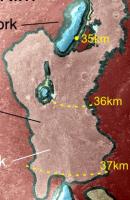
Now that Oppy is rolling again, she's getting close to 35km total odometry. That's 95% of the current 37km record for the longest distance of surface travel of any extra-terrestrial vehicle, set by the Russian rover Lunokhod 2 in 1973.
This quick sketch (cropped from a NASA Geological Map) shows that Oppy will reach 36km around Nobby's Head, and set a new record somewhere near the base of Solander Point. Although Oppy has just raced over 100m/sol, putting the record in theory within 20 sols, there's bound to be interesting targets along the way. An average of 25m/sol means the record will be broken on sol 3130. Anyone else care to hazard a guess?
|
|
|
|
|
|
|
Aug 22 2012, 12:39 PM
Post
#49
|
|
|
Junior Member Group: Members Posts: 27 Joined: 6-August 12 From: Leeds, Yorkshire, UK Member No.: 6469 |
QUOTE (Antonb @ Aug 22 2012, 01:21 PM) That's 95% of the current 37km record By the way, I do hope that breaking this record is on the list of remaining targets for Oppy to achieve. She richly deserves to hold this distance record, and it throws the gauntlet down to Curiosity just as her own wheels start to roll. |
|
|
|
|
Aug 22 2012, 12:54 PM
Post
#50
|
|
|
Senior Member Group: Members Posts: 2920 Joined: 14-February 06 From: Very close to the Pyrénées Mountains (France) Member No.: 682 |
Thank you Antonb. For the one that looks for more infos, see in "Statistics thread (post #223)": http://www.unmannedspaceflight.com/index.p...3705&st=210
-------------------- |
|
|
|
|
Aug 22 2012, 01:14 PM
Post
#51
|
||
 Senior Member Group: Members Posts: 2173 Joined: 28-December 04 From: Florida, USA Member No.: 132 |
QUOTE (Antonb @ Aug 22 2012, 08:39 AM) By the way, I do hope that breaking this record is on the list of remaining targets for Oppy to achieve.... In achieving the stated science goal of studying Cape Tribulation, Opportunity will surpass 40km. "...the planned exploration route goes south along the rim fragment "Solander Point," to "Cape Tribulation," where clay minerals have been detected."
http://www.nasa.gov/mission_pages/mer/mult...y/pia13708.html |
|
|
|
|
|
|
Aug 22 2012, 01:27 PM
Post
#52
|
|
|
Junior Member Group: Members Posts: 27 Joined: 6-August 12 From: Leeds, Yorkshire, UK Member No.: 6469 |
QUOTE (centsworth_II @ Aug 22 2012, 02:14 PM) In achieving the stated science goal of studying Cape Tribulation, Opportunity will surpass 40km. That's excellent, many thanks, I hadn't seen that. (BTW, I apologise for my faux pas on guessing, which I've been made aware of. It won't happen again.) |
|
|
|
|
Aug 22 2012, 02:04 PM
Post
#53
|
|
|
Senior Member Group: Members Posts: 4247 Joined: 17-January 05 Member No.: 152 |
Remember that there potentially are clays not far away here on CY, which are our primary goal. If we found something, you can bet we'd spend a long time studying them. So it's extremely hard to predict when we'd hit the distance record.
|
|
|
|
|
Aug 22 2012, 04:18 PM
Post
#54
|
|
|
Senior Member Group: Moderator Posts: 4279 Joined: 19-April 05 From: .br at .es Member No.: 253 |
QUOTE (SFJCody @ Aug 22 2012, 02:19 AM) A drive sol on 3049. If this is another 100m+er they'll put themselves about halfway down Cape York. 40m, according to the "telemetry". Can't verify that with the navcams because they look "underexposed" (JPEG stretching thing) and are of no use. I though they would stop to have a look at the rock (meteorite?) or the vein but that was not the case. However, it looks like there are some pancam shots on the downlink queue: Muruntau (the vein), Goldstrike (the rock) and a color mosaic of Shoemaker Ridge. |
|
|
|
|
Aug 22 2012, 04:42 PM
Post
#55
|
|
|
Member Group: Admin Posts: 976 Joined: 29-September 06 From: Pasadena, CA - USA Member No.: 1200 |
QUOTE (Tesheiner @ Aug 22 2012, 08:18 AM) 40m, according to the "telemetry". Can't verify that with the navcams because they look "underexposed" (JPEG stretching thing) and are of no use. I though they would stop to have a look at the rock (meteorite?) or the vein but that was not the case. However, it looks like there are some pancam shots on the downlink queue: Muruntau (the vein), Goldstrike (the rock) and a color mosaic of Shoemaker Ridge. The odometry for B 3049 is about 40.8 meters. The drive was intended to be longer but I think we failed the second slip check because the terrain is so featureless that VO did not have anything to latch on and there are no rover tracks left because the soil is so hard. It doesn't look to me that glare in the NAVCAM was a problem (no glare in the VO Navcam thumbnails). Paolo -------------------- Disclaimer: all opinions, ideas and information included here are my own,and should not be intended to represent opinion or policy of my employer.
|
|
|
|
|
Aug 22 2012, 05:10 PM
Post
#56
|
|
|
Senior Member Group: Moderator Posts: 4279 Joined: 19-April 05 From: .br at .es Member No.: 253 |
Oh, I was refering to the "post-drive" navcam mosaic images not the ones used for VO. They look too dark, at least the public JPEGs, to register the mosaic with the map background and "refine" the current position.
|
|
|
|
|
Aug 22 2012, 05:42 PM
Post
#57
|
|
|
Senior Member Group: Members Posts: 4247 Joined: 17-January 05 Member No.: 152 |
QUOTE (RoverDriver @ Aug 22 2012, 04:42 PM) there are no rover tracks left because the soil is so hard Wow, those tracks sure are hard to see: http://qt.exploratorium.edu/mars/opportuni...0M1.JPG?sol3049 Made even harder by low sun (conspiring with tilt of surface here), perhaps. |
|
|
|
|
Aug 22 2012, 07:27 PM
Post
#58
|
|
|
Member Group: Admin Posts: 976 Joined: 29-September 06 From: Pasadena, CA - USA Member No.: 1200 |
QUOTE (Tesheiner @ Aug 22 2012, 09:10 AM) Oh, I was refering to the "post-drive" navcam mosaic images not the ones used for VO. They look too dark, at least the public JPEGs, to register the mosaic with the map background and "refine" the current position. Yes, the post drive NAVCAM are really dark because the SUN is shining into the field of view. What I meant to say is that the VO failure should not be attributed to glare. Sorry I was in a hurry to go and see the excitement of the first drive on the other side of the planet. ;-) Paolo -------------------- Disclaimer: all opinions, ideas and information included here are my own,and should not be intended to represent opinion or policy of my employer.
|
|
|
|
|
Aug 23 2012, 03:56 AM
Post
#59
|
|
|
Newbie Group: Members Posts: 4 Joined: 14-August 12 Member No.: 6557 |
Forgive me if this has already been posted (I did a quick search but can't seem to track down the specific posts), but I have a question about the glare. Has there been any publications or information NASA has published about the effects of glare on the visual odometry for Opportunity or Spirit? Has this been much of an issue on Mars for MER visodom? I have an understanding why glare affects feature tracking, I'm more interested in how it has affected Oppy or Spirit specifically. I'm in the process of writing a research proposal and this information would be very valuable. Even if it's just something qualitative to get the wheels turning, no pun intended
Thanks.Rob |
|
|
|
|
Aug 23 2012, 06:22 AM
Post
#60
|
|
|
Member Group: Admin Posts: 976 Joined: 29-September 06 From: Pasadena, CA - USA Member No.: 1200 |
I have never seen any VO image that was affected by glare from either rover. And tosol VO failure is not due to glare either. Typically we point the cameras down at about 30 deg below the horizon to
have a good view of the tracks. With such a low elevation angle it is difficult to have glare. Even Autonav pointing is pretty low as well. Here, as I was saying earlier, there were no features to track (remember the on-board processing uses 256x256 pixel images) and there were no track markings on the ground. Even if we had pointed teh NAVCAMs straight down it would have been likely that VO would have failed. The glare in the post-drive NAVCAMs is mostly due to the dust deposition on the lens. Post drive NAVs are usually taken at -17 deg elevation and in early afternoon. Leave a digital camera for 8+ years in the desert, lens cap off, then try to take a picture late in the afternoon while pointing the camera at the horizon to the West. Assuming the shutter release still works after 8 years, that is. One of the optical engineers (Reg Wilson) published a paper on the effects of dust deposits on the lens and CCD sensor. I don't have a reference, but if you look up Reg Wilson on the JPL web site very likely he has that paper listed. Paolo -------------------- Disclaimer: all opinions, ideas and information included here are my own,and should not be intended to represent opinion or policy of my employer.
|
|
|
|
|
Aug 23 2012, 10:44 AM
Post
#61
|
|
|
Member Group: Members Posts: 813 Joined: 29-December 05 From: NE Oh, USA Member No.: 627 |
Have we ever been on such hard ground?
Lower dust fraction possibly exposing clays minerals making then faintly visible from orbit? Craig |
|
|
|
|
Aug 23 2012, 02:05 PM
Post
#62
|
|
|
Member Group: Admin Posts: 976 Joined: 29-September 06 From: Pasadena, CA - USA Member No.: 1200 |
QUOTE (belleraphon1 @ Aug 23 2012, 02:44 AM) Have we ever been on such hard ground? Lower dust fraction possibly exposing clays minerals making then faintly visible from orbit? Craig We have been on really hard packed soil but usually we leave at least some markings. Here we are leaving hardly any! Never seen anything like it. Paolo -------------------- Disclaimer: all opinions, ideas and information included here are my own,and should not be intended to represent opinion or policy of my employer.
|
|
|
|
|
Aug 23 2012, 03:34 PM
Post
#63
|
|
|
Member Group: Members Posts: 507 Joined: 10-September 08 Member No.: 4338 |
In reply 430 in the Exploration of Cape York thread of the MarsRoverBlog open forum, Hortonheardawho has an animation showing tracks that apparently faded in the space of only 3 minutes.
|
|
|
|
|
Aug 23 2012, 05:32 PM
Post
#64
|
||
|
Senior Member Group: Moderator Posts: 4279 Joined: 19-April 05 From: .br at .es Member No.: 253 |
Here's (part of) the mosaic taken by the navcam on sol 3049 i.e. the current position. There's a piece of ejecta (?) on sight, better seen on this pancam picture.
|
|
|
|
|
|
|
Aug 23 2012, 05:55 PM
Post
#65
|
|||
|
Senior Member Group: Members Posts: 4247 Joined: 17-January 05 Member No.: 152 |
This is another cool view. And we're starting to get a better look at the two dark smudges coming up:
In stereo, you can see that they're depressions, but very different from the crater in between them:
Perhaps they're related to Whim Creek? And a closeup of Goldstrike (meteorite?) is down too: http://qt.exploratorium.edu/mars/opportuni...2M1.JPG?sol3049 |
||
|
|
|
||
|
Aug 23 2012, 06:05 PM
Post
#66
|
|
|
Member Group: Admin Posts: 976 Joined: 29-September 06 From: Pasadena, CA - USA Member No.: 1200 |
QUOTE (marsophile @ Aug 23 2012, 07:34 AM) In reply 430 in the Exploration of Cape York thread of the MarsRoverBlog open forum, Hortonheardawho has an animation showing tracks that apparently faded in the space of only 3 minutes. Thanks for pointing me to this forum. I was not aware of it. The animation seems to be relative to Sol 3044, so it is the same kind of material we are currently driving on and there are barely any tracks visible. Oppy is driving on cement! Paolo -------------------- Disclaimer: all opinions, ideas and information included here are my own,and should not be intended to represent opinion or policy of my employer.
|
|
|
|
|
Aug 23 2012, 09:14 PM
Post
#67
|
|
|
Senior Member Group: Members Posts: 1583 Joined: 14-October 05 From: Vermont Member No.: 530 |
The yellow forum had the unfortunate tendency to degenerate into xenopomorphizing rocks. High noise to signal.
|
|
|
|
|
Aug 24 2012, 10:51 AM
Post
#68
|
|
|
Member Group: Members Posts: 813 Joined: 29-December 05 From: NE Oh, USA Member No.: 627 |
QUOTE (marsophile @ Aug 23 2012, 10:34 AM) In reply 430 in the Exploration of Cape York thread of the MarsRoverBlog open forum, Hortonheardawho has an animation showing tracks that apparently faded in the space of only 3 minutes. Thanks Paolo and marsophile for your replies. Was not aware of the forum above either. Wow.... what a fascinating change! |
|
|
|
|
Aug 24 2012, 12:01 PM
Post
#69
|
|
|
Newbie Group: Members Posts: 4 Joined: 14-August 12 Member No.: 6557 |
QUOTE (RoverDriver @ Aug 23 2012, 02:22 AM) I have never seen any VO image that was affected by glare from either rover. And tosol VO failure is not due to glare either. Typically we point the cameras down at about 30 deg below the horizon to have a good view of the tracks. With such a low elevation angle it is difficult to have glare. Even Autonav pointing is pretty low as well. Here, as I was saying earlier, there were no features to track (remember the on-board processing uses 256x256 pixel images) and there were no track markings on the ground. Even if we had pointed teh NAVCAMs straight down it would have been likely that VO would have failed. The glare in the post-drive NAVCAMs is mostly due to the dust deposition on the lens. Post drive NAVs are usually taken at -17 deg elevation and in early afternoon. Leave a digital camera for 8+ years in the desert, lens cap off, then try to take a picture late in the afternoon while pointing the camera at the horizon to the West. Assuming the shutter release still works after 8 years, that is. One of the optical engineers (Reg Wilson) published a paper on the effects of dust deposits on the lens and CCD sensor. I don't have a reference, but if you look up Reg Wilson on the JPL web site very likely he has that paper listed. Paolo Thanks for the reply Paolo, very useful information. I wonder, when operating the rover are lighting conditions a constraint on the time period it may drive (I'd think at some point the images become too dark to operate visual odometry properly), or if other things restrict it before it comes to that, like power? Very interesting to see that the rover is barely leaving any tracks! I love that 8+ years later Opportunity is still amazing us. Rob |
|
|
|
|
Aug 24 2012, 02:25 PM
Post
#70
|
|
|
Member Group: Members Posts: 813 Joined: 29-December 05 From: NE Oh, USA Member No.: 627 |
QUOTE (belleraphon1 @ Aug 24 2012, 05:51 AM) Thanks Paolo and marsophile for your replies. Was not aware of the forum above either. Wow.... what a fascinating change! In an attempt to keep my own SNR level up (sometimes hard) could the change seen from the Opportunity image 398419876 to 398420030 be just a lighting or filter effect? Fading Wheel tracks???? http://qt.exploratorium.edu/mars/opportuni...H0F0006R0M1.JPG http://qt.exploratorium.edu/mars/opportuni...H2F0006L0M1.JPG Some mornings I really need to curb my enthusiasm. Craig |
|
|
|
|
Aug 24 2012, 02:46 PM
Post
#71
|
|
|
Senior Member Group: Members Posts: 4247 Joined: 17-January 05 Member No.: 152 |
Better to compare the two left frames or the two right frames to minimize viewing angle differences:
http://qt.exploratorium.edu/mars/opportuni...0M1.JPG?sol3044 http://qt.exploratorium.edu/mars/opportuni...0M1.JPG?sol3044 I'd be surprized if this was a lighting effect, since at midday the sun's pretty high, and the effect we're seeing is not too far below the horizon, so not where you'd be catching reflections from the sun. Plus the two frames are only a couple of minutes apart. And they have identical filters. IIRC, we have seen similar things over longer intervals after wind gusts. So one guess is we had a good strong gust between these two frames almost erase the tracks. BTW, another lovely shadow-reaching-into-the-crater shot: http://qt.exploratorium.edu/mars/opportuni...0M1.JPG?sol3051 |
|
|
|
|
Aug 24 2012, 02:53 PM
Post
#72
|
|
|
Senior Member Group: Members Posts: 2173 Joined: 28-December 04 From: Florida, USA Member No.: 132 |
QUOTE (fredk @ Aug 24 2012, 10:46 AM) ...one guess is we had a good strong gust between these two frames almost erase the tracks.... Any sign of a cleaning event on the solar panels?
|
|
|
|
|
Aug 24 2012, 03:05 PM
Post
#73
|
|
|
Member Group: Members Posts: 813 Joined: 29-December 05 From: NE Oh, USA Member No.: 627 |
Thanks fredk....
just not used to what seems (to me) such an abrupt change. Craig |
|
|
|
|
Aug 24 2012, 03:54 PM
Post
#74
|
|
|
Member Group: Admin Posts: 976 Joined: 29-September 06 From: Pasadena, CA - USA Member No.: 1200 |
QUOTE (neorobo @ Aug 24 2012, 04:01 AM) Thanks for the reply Paolo, very useful information. I wonder, when operating the rover are lighting conditions a constraint on the time period it may drive (I'd think at some point the images become too dark to operate visual odometry properly), or if other things restrict it before it comes to that, like power? Very interesting to see that the rover is barely leaving any tracks! I love that 8+ years later Opportunity is still amazing us. Rob Lighting conditions have never been an issue for driving as we typically try to drive "blind" (no VO or Autonav). Lighting conditions are usually always analyzed when using the MI as we try to avoid frames where part of the target is in direct sunlight and part is in shadow. If it is required, we sometimes change the IDD configuration to use a different wrist position and very rarely we have moved teh time when the IDD sequence begins to have more favorable Sun position. This is what happened so far but I guess that our current position it might not be a bad idea to think about lighting conditions for driving as well. Paolo -------------------- Disclaimer: all opinions, ideas and information included here are my own,and should not be intended to represent opinion or policy of my employer.
|
|
|
|
|
Aug 24 2012, 06:18 PM
Post
#75
|
|
|
Founder Group: Chairman Posts: 14432 Joined: 8-February 04 Member No.: 1 |
QUOTE (fredk @ Aug 24 2012, 07:46 AM) So one guess is we had a good strong gust between these two frames almost erase the tracks. Looking at this near concrete like surface - it reminds me of desert pavement - ( http://www2.mcdaniel.edu/Biology/wildameri...sertgeolgy.html ) - lots of strong winds over time blow away what little dust is there and leave behind small pebbles etc settled into an almost hard packed surface. Those winds I'd bet are fairly consistently high, what with a tens of miles run up from the East. Thus - rover drives over a surface that's not been touched by anything but wind for Gy's - and pushes a few pebbles down, pushes a bit of dirt around. That wind is, very quickly, going to get that dirt out of there and 'rebuild' back to the pavement formation where the dirt is now hidden from the wind between the pebbles. We saw it happen on tracks we re-visited outside Endurance crater - but here it's just happened much quicker. |
|
|
|
|
Aug 24 2012, 06:55 PM
Post
#76
|
|
|
Member Group: Members Posts: 813 Joined: 29-December 05 From: NE Oh, USA Member No.: 627 |
Thanks all for the comments.
It is just incredible to me that we have these phenomenal machines that MOVE into new environments. Wow again. Luv this! |
|
|
|
|
Aug 24 2012, 10:19 PM
Post
#77
|
|
|
Member Group: Members Posts: 813 Joined: 29-December 05 From: NE Oh, USA Member No.: 627 |
I know that MOC and HRISE have shown us how dynamic Mars really is. Polar avalanches and moving dunes and CO2 evaporation at the S. Pole.
Just did not expect to see quick changes in Opportunity images. Here we are on the east rim of an ancient crater that has seen (as Doug pointed out) G-years of wind erosion. And Oppy caught that process in the act. How evocative is that! Stu, I think there is a poem here. Irony is that I have always thought Mars is more active than we give him credit. then we see direct evidence of that and I question it. Man.... I love these rovers and orbiters and all the people who make this happen. And THIS forum.... Craig |
|
|
|
| Guest_Oersted_* |
Aug 27 2012, 10:51 AM
Post
#78
|
|
Guests |
Isn´t Horton a member of this forum too? I´d love for him to post his anim gif here as well. (Don´t really feel like following two different forums...)
|
|
|
|
|
Aug 27 2012, 04:07 PM
Post
#79
|
|
|
Member Group: Admin Posts: 976 Joined: 29-September 06 From: Pasadena, CA - USA Member No.: 1200 |
QUOTE (djellison @ Aug 24 2012, 10:18 AM) ... Those winds I'd bet are fairly consistently high, what with a tens of miles run up from the East. ... Hey, winds, how a bout a dust cleaning? Power is still at the same level we have been having for the past 10 Sols or so. Dust factor has not changed! Paolo -------------------- Disclaimer: all opinions, ideas and information included here are my own,and should not be intended to represent opinion or policy of my employer.
|
|
|
|
|
Aug 27 2012, 05:19 PM
Post
#80
|
|
|
Senior Member Group: Members Posts: 4247 Joined: 17-January 05 Member No.: 152 |
Well, here we are at about the midpoint down CY, and look at all the pretty gypsummy-looking veins:
http://qt.exploratorium.edu/mars/opportuni...2M1.JPG?sol3054 http://qt.exploratorium.edu/mars/opportuni...0M1.JPG?sol3054 |
|
|
|
|
Aug 27 2012, 05:51 PM
Post
#81
|
|
|
Solar System Cartographer Group: Members Posts: 10164 Joined: 5-April 05 From: Canada Member No.: 227 |
Finally we may have one big enough for a brushing.
Phil -------------------- ... because the Solar System ain't gonna map itself.
Also to be found posting similar content on https://mastodon.social/@PhilStooke Maps for download (free PD: https://upload.wikimedia.org/wikipedia/comm...Cartography.pdf NOTE: everything created by me which I post on UMSF is considered to be in the public domain (NOT CC, public domain) |
|
|
|
|
Aug 27 2012, 06:43 PM
Post
#82
|
||
|
The Poet Dude Group: Moderator Posts: 5551 Joined: 15-March 04 From: Kendal, Cumbria, UK Member No.: 60 |
Is that "Knobby's Head" starting to appear over the end of the Cape now..?
-------------------- |
|
|
|
|
|
|
Aug 27 2012, 06:47 PM
Post
#83
|
||
|
Senior Member Group: Moderator Posts: 4279 Joined: 19-April 05 From: .br at .es Member No.: 253 |
I think so!
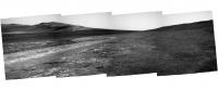
Here's my take on the navcam mosaic. Man, I really like this place.
|
|
|
|
|
|
|
Aug 27 2012, 06:47 PM
Post
#84
|
|
|
Solar System Cartographer Group: Members Posts: 10164 Joined: 5-April 05 From: Canada Member No.: 227 |
Yep, looks like it is.
Phil -------------------- ... because the Solar System ain't gonna map itself.
Also to be found posting similar content on https://mastodon.social/@PhilStooke Maps for download (free PD: https://upload.wikimedia.org/wikipedia/comm...Cartography.pdf NOTE: everything created by me which I post on UMSF is considered to be in the public domain (NOT CC, public domain) |
|
|
|
|
Aug 27 2012, 07:52 PM
Post
#85
|
|
|
Senior Member Group: Members Posts: 2920 Joined: 14-February 06 From: Very close to the Pyrénées Mountains (France) Member No.: 682 |
QUOTE (RoverDriver @ Aug 27 2012, 06:07 PM) Hey, winds, how a bout a dust cleaning? Power is still at the same level we have been having for the past 10 Sols or so. Dust factor has not changed! Paolo Don't worry, be Oppy
-------------------- |
|
|
|
|
Aug 28 2012, 01:41 AM
Post
#86
|
|
|
Senior Member Group: Members Posts: 2228 Joined: 1-December 04 From: Marble Falls, Texas, USA Member No.: 116 |
QUOTE (RoverDriver @ Aug 27 2012, 11:07 AM) ... Dust factor has not changed! I guess we can't assume that wind erased the rover track after all.QUOTE (Tesheiner @ Aug 27 2012, 01:47 PM) ... Man, I really like this place. No kidding. I wouldn't mind sticking around here for a while, but I think we have at least 2 or 3 more drives before we get to the phyllosilicate area.-------------------- ...Tom
I'm not a Space Fan, I'm a Space Exploration Enthusiast. |
|
|
|
|
Aug 28 2012, 07:28 AM
Post
#87
|
|
|
Member Group: Members Posts: 404 Joined: 5-January 10 Member No.: 5161 |
Those veins are very bright. Are these bright rocks thought to be of the same make as the Homestake rock? They seem much brighter here, totally blown highlights. I don't recall seeing anything like it.
|
|
|
|
|
Aug 29 2012, 10:35 AM
Post
#88
|
|
|
The Poet Dude Group: Moderator Posts: 5551 Joined: 15-March 04 From: Kendal, Cumbria, UK Member No.: 60 |
Looks like Oppy has started to drive uphill, towards some ridges higher up...
http://qt.exploratorium.edu/mars/opportuni...IWP1211L0M1.JPG She's on the trail of something, maybe...?
-------------------- |
|
|
|
|
Aug 29 2012, 10:55 AM
Post
#89
|
||
|
Senior Member Group: Moderator Posts: 4279 Joined: 19-April 05 From: .br at .es Member No.: 253 |
The name of some imaging sequences from today say something about it.
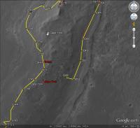
03056::p1957::13::6::0::0::4::0::10::nav_2x1_site_vein_2bpp_pri57 03056::p2555::30::8::8::0::0::2::18::pancam_sinuous_vein_L257R12467 And just a quick snapshot from GE to put in context. I will properly update the map thread later on.
BTW, we crossed the 35km mark during today's drive. |
|
|
|
|
|
|
Aug 29 2012, 11:09 AM
Post
#90
|
|
|
Senior Member Group: Members Posts: 2920 Joined: 14-February 06 From: Very close to the Pyrénées Mountains (France) Member No.: 682 |
QUOTE (Tesheiner @ Aug 29 2012, 12:55 PM) BTW, we crossed the 35km mark during today's drive. Nice, but this happened a mere 100m from the 34km mark  Now, only 900m to catch up with Apollo 17 rover and 2 km to break Lunakhod 2 leading mark! Go Oppy go and tell us what those veins are. -------------------- |
|
|
|
|
Aug 29 2012, 01:50 PM
Post
#91
|
|
|
Senior Member Group: Members Posts: 4247 Joined: 17-January 05 Member No.: 152 |
QUOTE (Tesheiner @ Aug 29 2012, 11:55 AM) The name of some imaging sequences from today say something about it. Those should have been taken before the 3056 drive, when we were still at the 3053 location surrounded by all the pretty veins. Since we've moved inland tosol, I'm guessing that we're going after the putative clays, since we're now halfway along CY. I know who I'm rooting for to reach the clays first!
|
|
|
|
|
Aug 29 2012, 02:05 PM
Post
#92
|
||
|
The Poet Dude Group: Moderator Posts: 5551 Joined: 15-March 04 From: Kendal, Cumbria, UK Member No.: 60 |
QUOTE (fredk @ Aug 29 2012, 02:50 PM) I'm guessing that we're going after the putative clays, since we're now halfway along CY. I know who I'm rooting for to reach the clays first! Well, she's heading towards these...
... so maybe it's prospecting time... -------------------- |
|
|
|
|
|
|
Aug 29 2012, 08:28 PM
Post
#93
|
||
|
Member Group: Members Posts: 404 Joined: 5-January 10 Member No.: 5161 |
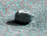
The rock from sol 3049 makes for a nice 3D.
|
|
|
|
|
|
|
Aug 29 2012, 09:12 PM
Post
#94
|
|
|
Senior Member Group: Moderator Posts: 4279 Joined: 19-April 05 From: .br at .es Member No.: 253 |
QUOTE (fredk @ Aug 29 2012, 03:50 PM) Those should have been taken before the 3056 drive, when we were still at the 3053 location surrounded by all the pretty veins. Checked it and the pancam shot was taken at the previous site but the navcam was shot "mid-drive" more or less around the 35km mark. |
|
|
|
|
Aug 29 2012, 10:17 PM
Post
#95
|
|
 Senior Member Group: Members Posts: 3419 Joined: 9-February 04 From: Minneapolis, MN, USA Member No.: 15 |
Just have a curiosity (small C) -- if we do get to some phyllosilicates, what does Oppy have left to bring to bear for examination?
I imagine we can at least brush the rock surface and the APXS should still give us some good data. And we can take some MI images. But is the Mossbauer capable of getting good spectra anymore? And if not, how much info can we get with what we got left? Again, just curious. -the other Doug -------------------- The trouble ain't that there is too many fools, but that the lightning ain't distributed right. -Mark Twain
|
|
|
|
|
Aug 29 2012, 11:27 PM
Post
#96
|
|
|
Senior Member Group: Members Posts: 4247 Joined: 17-January 05 Member No.: 152 |
After the attempt at a looooong MB integration at Greeley this winter, they decided that it was no longer useful, IIRC.
|
|
|
|
|
Aug 30 2012, 12:40 AM
Post
#97
|
|
|
Member Group: Members Posts: 507 Joined: 10-September 08 Member No.: 4338 |
QUOTE (dvandorn @ Aug 29 2012, 02:17 PM) if we do get to some phyllosilicates, what does Oppy have left to bring to bear for examination? The APXS will give elemental composition, and the MI morphology, but that may not be enough for a definitive identification. In the long run, comparison of the weak signature at Cape York with the strong signature at Cape Tribulation may be very suggestive, i.e., If there is some distinctive feature at Cape York, and a lot more of it at Cape Tribulation, then Oppy may have identified something that is correlated with the phyllosilicates. Curiosity can then investigate similar features with its full complement of instruments. |
|
|
|
|
Aug 30 2012, 06:08 AM
Post
#98
|
||
|
Junior Member Group: Members Posts: 52 Joined: 1-March 11 From: Houston, USA Member No.: 5860 |
Tesheiner's map from post #89 overlaid with the CRISM data from http://www.planetary.org/blogs/emily-lakda.../2011/3134.html .
|
|
|
|
|
|
|
Aug 30 2012, 07:36 AM
Post
#99
|
|
|
Solar System Cartographer Group: Members Posts: 10164 Joined: 5-April 05 From: Canada Member No.: 227 |
The full set of filters in mutispectral images will help as well, though I don't know how much in this context.
Phil -------------------- ... because the Solar System ain't gonna map itself.
Also to be found posting similar content on https://mastodon.social/@PhilStooke Maps for download (free PD: https://upload.wikimedia.org/wikipedia/comm...Cartography.pdf NOTE: everything created by me which I post on UMSF is considered to be in the public domain (NOT CC, public domain) |
|
|
|
|
Aug 30 2012, 12:13 PM
Post
#100
|
||
|
Senior Member Group: Moderator Posts: 4279 Joined: 19-April 05 From: .br at .es Member No.: 253 |
A 12m "bump" was executed on sol 3057.
Here's the "post-drive" navcam mosaic.
|
|
|
|
|
|
|

|
Lo-Fi Version | Time is now: 20th May 2024 - 05:09 AM |
|
RULES AND GUIDELINES Please read the Forum Rules and Guidelines before posting. IMAGE COPYRIGHT |
OPINIONS AND MODERATION Opinions expressed on UnmannedSpaceflight.com are those of the individual posters and do not necessarily reflect the opinions of UnmannedSpaceflight.com or The Planetary Society. The all-volunteer UnmannedSpaceflight.com moderation team is wholly independent of The Planetary Society. The Planetary Society has no influence over decisions made by the UnmannedSpaceflight.com moderators. |
SUPPORT THE FORUM Unmannedspaceflight.com is funded by the Planetary Society. Please consider supporting our work and many other projects by donating to the Society or becoming a member. |
|