MRO-HiRISE, interesting images |

  |
MRO-HiRISE, interesting images |
 Jan 11 2017, 10:50 AM Jan 11 2017, 10:50 AM
Post
#31
|
|
|
Member  Group: Members Posts: 923 Joined: 10-November 15 Member No.: 7837 |
There is a to-scale astronaut in the following image...
 -------------------- |
 |
 
|
|
Jan 11 2017, 06:48 PM
Post
#32
|
|
|
Member Group: Members Posts: 205 Joined: 14-April 06 From: Seattle, WA Member No.: 745 |
Found her!
Thanks for this challenge. Great way to inspect this incredible terrain. (Or should that Arerrain?) |
|
|
|
|
Jan 12 2017, 12:49 AM
Post
#33
|
|
|
Member Group: Members Posts: 923 Joined: 10-November 15 Member No.: 7837 |
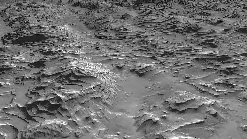
So it turns out that this area is Domoni crater and the nice folk at PIRL let me know that HiRISE had full coverage so I was able to extend the scene in 3D to provide the following images...
   using these assets... http://www.uahirise.org/dtm/dtm.php?ID=ESP_016490_2315 http://www.uahirise.org/dtm/dtm.php?ID=ESP_016846_2320 http://www.uahirise.org/dtm/dtm.php?ID=ESP_016213_2315 -------------------- |
|
|
|
|
Jan 12 2017, 02:15 PM
Post
#34
|
|
|
Member Group: Members Posts: 715 Joined: 22-April 05 Member No.: 351 |
Thank you for sharing these!
-------------------- |
|
|
|
|
Jan 13 2017, 01:57 PM
Post
#35
|
|
|
Member Group: Members Posts: 923 Joined: 10-November 15 Member No.: 7837 |
Click thru for a video tour of Domoni Crater...
-------------------- |
|
|
|
|
Jan 13 2017, 09:37 PM
Post
#36
|
|
|
Member Group: Members Posts: 923 Joined: 10-November 15 Member No.: 7837 |
-------------------- |
|
|
|
|
Jan 14 2017, 07:54 AM
Post
#37
|
|
|
Member Group: Members Posts: 923 Joined: 10-November 15 Member No.: 7837 |
-------------------- |
|
|
|
|
Jan 14 2017, 08:56 AM
Post
#38
|
|
 Senior Member Group: Members Posts: 2431 Joined: 30-January 13 From: Penang, Malaysia. Member No.: 6853 |
QUOTE (Sean @ Jan 14 2017, 03:54 PM)  Layers.... These are great Sean, have subscribed to email alerts this sub-forum so I dont miss any  Fingers crossed there is enough data that will enable you to create a few of Gale crater. If I could be permitted to throw an idea your way, maybe one of the entire path from landing from an elevated camera position, with tags on the ground for the rovers position every 50 sols or so? (just thinking out loud) Probably a big ask
|
|
|
|
|
Jan 14 2017, 09:56 AM
Post
#39
|
|
|
Member Group: Members Posts: 923 Joined: 10-November 15 Member No.: 7837 |
QUOTE (PaulH51 @ Jan 14 2017, 08:56 AM) These are great Sean, have subscribed to email alerts this sub-forum so I dont miss any Fingers crossed there is enough data that will enable you to create a few of Gale crater. If I could be permitted to throw an idea your way, maybe one of the entire path from landing from an elevated camera position, with tags on the ground for the rovers position every 50 sols or so? (just thinking out loud) Probably a big ask I'm working on Gale but its a big job and I want to do it justice... I'm filing the edges off the workflow with these posts. -------------------- |
|
|
|
|
Jan 14 2017, 09:59 AM
Post
#40
|
|
|
Member Group: Members Posts: 923 Joined: 10-November 15 Member No.: 7837 |
Can you spot the astronaut in this image?
 ( Answer is in the subsequent image on Flickr ) -------------------- |
|
|
|
|
Jan 15 2017, 02:46 PM
Post
#41
|
|
|
Member Group: Members Posts: 923 Joined: 10-November 15 Member No.: 7837 |
-------------------- |
|
|
|
|
Jan 15 2017, 03:17 PM
Post
#42
|
|
 Senior Member Group: Members Posts: 1669 Joined: 5-March 05 From: Boulder, CO Member No.: 184 |
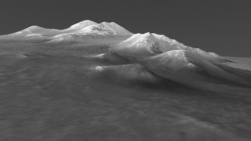
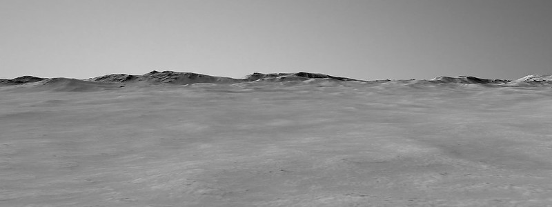
Amazing how much detail there is in all of these DTMs that Sean is bringing to life. I'm curious about what the brighter material is near some of the higher terrain. Nice to see an atmosphere showing up in the background. I wonder if future plans might also consider the effects of the atmosphere between the observer and the terrain?
-------------------- Steve [ my home page and planetary maps page ]
|
|
|
|
|
Jan 15 2017, 03:56 PM
Post
#43
|
|
|
Member Group: Members Posts: 923 Joined: 10-November 15 Member No.: 7837 |
Its on the list Steve. Although given the limited coverage of the area I wonder how much atmos to add.
-------------------- |
|
|
|
|
Jan 15 2017, 04:28 PM
Post
#44
|
|
|
Senior Member Group: Members Posts: 1669 Joined: 5-March 05 From: Boulder, CO Member No.: 184 |
Interesting question Sean. For a ballpark answer I would suggest that we can estimate an overall optical depth tau (~0.5) and dust scale height of 11km. This means the extinction coefficient at elevations near the ground would be 0.5/11km or 4.55 * 10^-5 m^-1 (tapering off exponentially as we go upward). From this both the inscatter and outscatter can be determined in the path between the observer and point on the terrain.
The impact might be subtle in the foreground, though becoming more noticeable for distant features in the background when looking near the sun. -------------------- Steve [ my home page and planetary maps page ]
|
|
|
|
|
Jan 15 2017, 05:05 PM
Post
#45
|
|
|
Member Group: Members Posts: 923 Joined: 10-November 15 Member No.: 7837 |
Thanks for your response Steve. Horizon haze is on the to do list as a priority.
-------------------- |
|
|
|
|

|
Lo-Fi Version | Time is now: 24th September 2024 - 04:32 PM |
|
RULES AND GUIDELINES Please read the Forum Rules and Guidelines before posting. IMAGE COPYRIGHT |
OPINIONS AND MODERATION Opinions expressed on UnmannedSpaceflight.com are those of the individual posters and do not necessarily reflect the opinions of UnmannedSpaceflight.com or The Planetary Society. The all-volunteer UnmannedSpaceflight.com moderation team is wholly independent of The Planetary Society. The Planetary Society has no influence over decisions made by the UnmannedSpaceflight.com moderators. |
SUPPORT THE FORUM Unmannedspaceflight.com is funded by the Planetary Society. Please consider supporting our work and many other projects by donating to the Society or becoming a member. |
|