Asteroid approach, Science operations begin! |

  |
Asteroid approach, Science operations begin! |
 Mar 20 2020, 10:04 AM Mar 20 2020, 10:04 AM
Post
#106
|
|
|
Member  Group: Members Posts: 435 Joined: 14-December 15 Member No.: 7860 |
|
 |
 
|
|
Mar 20 2020, 04:08 PM
Post
#107
|
|
|
Solar System Cartographer Group: Members Posts: 10149 Joined: 5-April 05 From: Canada Member No.: 227 |
Marcin600 - yes, I just noticed the mosaic has been released without names. When I can get to it I will put it in my map.
Phil -------------------- ... because the Solar System ain't gonna map itself.
Also to be found posting similar content on https://mastodon.social/@PhilStooke NOTE: everything created by me which I post on UMSF is considered to be in the public domain (NOT CC, public domain) |
|
|
|
|
Mar 20 2020, 10:13 PM
Post
#108
|
|
|
Member Group: Members Posts: 435 Joined: 14-December 15 Member No.: 7860 |
QUOTE (Phil Stooke @ Mar 20 2020, 05:08 PM)  Marcin600 - yes, I just noticed the mosaic has been released without names. When I can get to it I will put it in my map. Phil I get it (I gave the link just in case). Me and many people are waiting for your works - they are always perfect !  Marcin Ps. Is it possible to make polar projections (maps) from the materials you have so far from OSIRIS-REx? |
|
|
|
|
Mar 21 2020, 08:05 PM
Post
#109
|
||
|
Solar System Cartographer Group: Members Posts: 10149 Joined: 5-April 05 From: Canada Member No.: 227 |
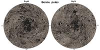
Polar projections...
These are not full polar hemispheres, they extend from 60 degrees N and S to the pole. Later I will make versions with grids, and full polar hemispheres. These are using the new mosaic. Phil -------------------- ... because the Solar System ain't gonna map itself.
Also to be found posting similar content on https://mastodon.social/@PhilStooke NOTE: everything created by me which I post on UMSF is considered to be in the public domain (NOT CC, public domain) |
|
|
|
|
|
|
Mar 22 2020, 04:47 AM
Post
#110
|
||
|
Member Group: Members Posts: 435 Joined: 14-December 15 Member No.: 7860 |
QUOTE (Phil Stooke @ Mar 21 2020, 09:05 PM) Polar projections...
These are not full polar hemispheres, they extend from 60 degrees N and S to the pole. Later I will make versions with grids, and full polar hemispheres. These are using the new mosaic. Phil Wow! How fast!  You're the best! You're the best!
|
|
|
|
|
|
|
Mar 25 2020, 03:52 AM
Post
#111
|
|
|
Senior Member Group: Members Posts: 2511 Joined: 13-September 05 Member No.: 497 |
Here's some more info about Natural Feature Tracking.
https://www.nasa.gov/feature/goddard/2020/b...hine-as-beacons Somehow, this blurb completely omits describing the camera being used for NFT or the organization that built it.  As far as I can tell, the plan is still to execute the first TAG rehearsal in April. At some point we may want a new thread. -------------------- Disclaimer: This post is based on public information only. Any opinions are my own.
|
|
|
|
|
Mar 28 2020, 09:27 PM
Post
#112
|
||
|
Solar System Cartographer Group: Members Posts: 10149 Joined: 5-April 05 From: Canada Member No.: 227 |
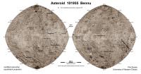
Here is a new map using the recently-released mission map as background.
Phil
-------------------- ... because the Solar System ain't gonna map itself.
Also to be found posting similar content on https://mastodon.social/@PhilStooke NOTE: everything created by me which I post on UMSF is considered to be in the public domain (NOT CC, public domain) |
|
|
|
|
|
|
Mar 31 2020, 08:57 PM
Post
#113
|
|
|
Solar System Cartographer Group: Members Posts: 10149 Joined: 5-April 05 From: Canada Member No.: 227 |
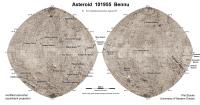
https://astrogeology.usgs.gov/news/nomencla...roved-for-bennu
A new set of names for Bennu's rocks, added to those already given. I will get them on the map as time permits. Nice to see Thorondor among them, me being a Tolkien addict from way back. Phil -------------------- ... because the Solar System ain't gonna map itself.
Also to be found posting similar content on https://mastodon.social/@PhilStooke NOTE: everything created by me which I post on UMSF is considered to be in the public domain (NOT CC, public domain) |
|
|
|
|
Mar 31 2020, 09:32 PM
Post
#114
|
||
|
Solar System Cartographer Group: Members Posts: 10149 Joined: 5-April 05 From: Canada Member No.: 227 |
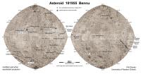
Time permitted. New map, new names.
Phil
-------------------- ... because the Solar System ain't gonna map itself.
Also to be found posting similar content on https://mastodon.social/@PhilStooke NOTE: everything created by me which I post on UMSF is considered to be in the public domain (NOT CC, public domain) |
|
|
|
|
|
|
Apr 4 2020, 06:42 PM
Post
#115
|
||
|
Solar System Cartographer Group: Members Posts: 10149 Joined: 5-April 05 From: Canada Member No.: 227 |
OK, now I'm adding the locations of the three particle ejection events reported so far.
Phil
-------------------- ... because the Solar System ain't gonna map itself.
Also to be found posting similar content on https://mastodon.social/@PhilStooke NOTE: everything created by me which I post on UMSF is considered to be in the public domain (NOT CC, public domain) |
|
|
|
|
|
|
Apr 5 2020, 12:40 PM
Post
#116
|
|
|
Member Group: Members Posts: 140 Joined: 20-November 07 Member No.: 3967 |
Hmm. Three. And all in the same hemisphere. Ain't that kinda curious . . .
Three debris fields . . . hmm again: Let's abstract the situation: Three relatively closely spaced points on a roughly spherical object make a triangle. Now toy with it . . . connect each point with the center of its opposing side to find the triangle's centroid (where the lines intersect inside the triangle); extending those lines across [around?] the opposite hemisphere determines another point of intersection. Use this antipodal intersection point to interrupt the surface and "unpeel" it along those extended medians a little bit——say 30 arc-degrees so we stay well distant from the debris fields——and use that extent of unpeeling-the-orange to create a Constant-Scale Natural Boundary map well suited to comprehensively study the debris fields and their interactions if any. Alternatively, assuming no access to CSNB software, use 1) the antipodal point as the edge of an azimuthal equidistant projection to get a standard map crudely suitable for the same purpose, with severe distortion causing trouble only within say 30º of the map's edge. This won't be a problem if semi-orbital dust transport is not in play. The severe edge distortion can be eliminated by 2) an Oblique Peirce Quincuncial projection centered on the nearside centroid, rotated so the cross is a best fit with the medians. You'll get four far-side 45º "flaps" instead of the three 30º flaps you'd get with CSNB, so expect some map-edge interruption of the debris fields if semi-orbital dust transport is occurring. This could be minimized by 3) Setting up a digital 3-D model and glancing back and forth between it and either of the imperfect conventional maps and——assuming you've got above-average short-term memory——thereby sniffing out airborne debris interactions if any. Just thinking out loud while Sopranos S2 E13 loads . . . |
|
|
|
|
Apr 7 2020, 03:13 PM
Post
#117
|
|
|
Member Group: Members Posts: 103 Joined: 3-February 20 From: Paris (France) Member No.: 8747 |
Greetings to you all,
Looking back on two recent images of Bennu proposed by Marcin: http://www.unmannedspaceflight.com/index.p...st&id=45133 http://www.unmannedspaceflight.com/uploads...99384_thumb.png I'm not a geologist, but I know the cleavages and cleavage planes in mineralogy or crystallography, the sometimes surprising forms that nature offers us and all things proper to cause our perplexity. For the case of these geometric forms on this scale, present on a rubble pile, does anyone have explanations, hypotheses or even ideas that would distance us from mere chance? Are you aware of other similar examples in the large catalogue of spatial imaging of asteroids? |
|
|
|
|
Apr 7 2020, 10:09 PM
Post
#118
|
|
 Member Group: Members Posts: 699 Joined: 3-December 04 From: Boulder, Colorado, USA Member No.: 117 |
Straight-line fractures ("joints") are pretty common on Earth- here's one example. They are a natural result of tectonic or other stresses in homogeneous rocks, and are different from the cleavage patterns you see in single crystals. The interesting question is what type of stresses (impact? thermal?) might do this on an asteroid surface.
John |
|
|
|
|
Apr 8 2020, 08:20 AM
Post
#119
|
|
 Senior Member Group: Members Posts: 2530 Joined: 20-April 05 Member No.: 321 |
Bennu originated as a fragment of a larger body, so both the breakup event and the possible forces within the parent body seem to be more likely sources of fractures than anything that would occur in a body the size of Bennu.
|
|
|
|
|
Apr 8 2020, 10:44 AM
Post
#120
|
|
|
Member Group: Members Posts: 103 Joined: 3-February 20 From: Paris (France) Member No.: 8747 |
QUOTE (john_s @ Apr 7 2020, 11:09 PM) Straight-line fractures ("joints") are pretty common on Earth- here's one example. They are a natural result of tectonic or other stresses in homogeneous rocks, and are different from the cleavage patterns you see in single crystals. The interesting question is what type of stresses (impact? thermal?) might do this on an asteroid surface. John Thank you very much John for your answer. The Earth example you give us to see is spectacular and I know of others quite similar for our planet: https://upload.wikimedia.org/wikipedia/comm..._Damaraland.JPG http://cirquedebarrosa.free.fr/Images/robdiaclase6.JPG But the context and the training processes are well known, there is no mystery. I never thought of comparing the large rock fractures on Bennu with crystalline cleavages. I was simply referring to natural geometries. It is the observation that you make at the end of your intervention, specific to asteroids, that intrigues me. The question can indeed be asked about the type of stress but perhaps also about the type of rock involved (or at least some of its characteristics). |
|
|
|
|

|
Lo-Fi Version | Time is now: 23rd April 2024 - 05:22 AM |
|
RULES AND GUIDELINES Please read the Forum Rules and Guidelines before posting. IMAGE COPYRIGHT |
OPINIONS AND MODERATION Opinions expressed on UnmannedSpaceflight.com are those of the individual posters and do not necessarily reflect the opinions of UnmannedSpaceflight.com or The Planetary Society. The all-volunteer UnmannedSpaceflight.com moderation team is wholly independent of The Planetary Society. The Planetary Society has no influence over decisions made by the UnmannedSpaceflight.com moderators. |
SUPPORT THE FORUM Unmannedspaceflight.com is funded by the Planetary Society. Please consider supporting our work and many other projects by donating to the Society or becoming a member. |
|