Opportunity Route Map |

  |
Opportunity Route Map |
 Aug 23 2006, 07:14 AM Aug 23 2006, 07:14 AM
Post
#1816
|
||
|
Senior Member  Group: Moderator Posts: 4279 Joined: 19-April 05 From: .br at .es Member No.: 253 |
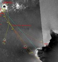
And here is part of my route map where I activated the layers showing the heading lines I usually use to double-check a sol's position.
The ones for sol 914 were taken from the navcams (using APG) while the lines for 916 are derived from a polar projection of the latest "drive direction" pancam mosaic. There is a clear discrepancy, at least when using this basemap image, and as I said before I'll try to correct this part of the route when we get closer to Epsilon (if we continue driving towards it).
|
|
 |
 
|
|
|
Aug 23 2006, 11:30 AM
Post
#1817
|
|
|
Junior Member Group: Members Posts: 77 Joined: 27-June 04 From: Queensland Australia Member No.: 90 |
At this rate, we'll be at the rim by next weekend
 A quick word of appreciation from a long-term lurker, Tesheiner. I'm sure that I'm not the only one who checks this thread religiously every day. I appreciate how much you've refined your MER tracking techniques over the last two years. The question is what shall we all do once the MER rovers finally grind to a halt? Is there life after MER? |
|
|
|
|
Aug 23 2006, 12:13 PM
Post
#1818
|
|
 Member Group: Members Posts: 136 Joined: 13-October 05 From: Malibu, CA Member No.: 527 |
QUOTE (Aldebaran @ Aug 23 2006, 04:30 AM)  Is there life after MER? Yep... but it'll have two missing bright spots. I've been, and most everyone else here, has been having a great time watching one of the most interesting adventures in the history of mankind - two, not just one, little machines crawling around on a planet (old moon, it seems) for now more than two years. It has been a time full of drama, discovery, and surprise. A steady stream of pictures that have amazed and confounded. I'll sure miss it all when these two little machines are finally retired somewhere. One consolation - there'll be the next set of exploratory vehicles - bigger, faster and packing new abilities that'll keep us glued to the pictures they send to us. |
|
|
|
|
Aug 23 2006, 12:14 PM
Post
#1819
|
|
 Member Group: Members Posts: 656 Joined: 20-April 05 From: League City, Texas Member No.: 285 |
QUOTE (Tesheiner @ Aug 23 2006, 02:14 AM) And here is part of my route map where I activated the layers showing the heading lines I usually use to double-check a sol's position. The ones for sol 914 were taken from the navcams (using APG) while the lines for 916 are derived from a polar I'm curious as to what software you're using to do the overlays. Photoshop? Or something custom? One thing that caught me by surprise, and shouldn't have, is that I had expected the hillocks to be useful navigational references once we got out onto the annulus, and of course being about the same height or less as the annulus, they're not. Makes me wish sometimes that the rovers carried sets of little flags that they could plant at various sites, just to provide a subsequent reference target Perhaps a can of fluorescent orange spray paint to mark rocks with on the MSL? (okay, orange might be a bad choice...)
|
|
|
|
|
Aug 23 2006, 12:22 PM
Post
#1820
|
|
|
Member Group: Members Posts: 656 Joined: 20-April 05 From: League City, Texas Member No.: 285 |
QUOTE (Aldebaran @ Aug 23 2006, 06:30 AM) Is there life after MER? I'm thinking that it's perhaps premature to assume that Victoria is where it ends, at least for Oppy. At this point it is not inconceivable that Oppy may later head off to the east and visit that big crater whose northern rim forms the Twin Peaks. It's not dramatically further away than we've already driven, and Oppy seems pretty healthy. Otherwise there's some interesting geography to the south. And of course there's Spirit and a thorough exploration of the environs of Home Plate coming up. Next of course there's Phoenix, which will almost certainly overlap with MER point (though a relatively brief overlap). MSL seems a long way off though :/ |
|
|
|
|
Aug 23 2006, 01:04 PM
Post
#1821
|
|
|
Senior Member Group: Moderator Posts: 4279 Joined: 19-April 05 From: .br at .es Member No.: 253 |
QUOTE (algorimancer @ Aug 23 2006, 02:14 PM) I'm curious as to what software you're using to do the overlays. Photoshop? Or something custom? I had no Photoshop available when I started tracking the rovers position last year, so I searched for no $$$ tools and found Serif PhotoPlus. I've been using this suite (I'm currently using v6) since then with the idea to change to Photoshop when possible. Now I have photoshop too, but I found it's not directly possible to migrate the map (not the results I post here, but the original file with *all* the different layers -- background maps, ground features, route, future path, [hidden] polar projections and heading lines, etc.) from one tool to the other one, so I continue using Serif PhotoPlus. QUOTE (sattrackpro @ Aug 23 2006, 02:13 PM) One consolation - there'll be the next set of exploratory vehicles - bigger, faster and packing new abilities that'll keep us glued to the pictures they send to us. My consolation too, BUT I'm afraid the data availability we have with MER will be unique. I hope they repeat the same successful approach with the next rover but I'm not so sure. |
|
|
|
|
Aug 23 2006, 08:41 PM
Post
#1822
|
||
|
Senior Member Group: Moderator Posts: 4279 Joined: 19-April 05 From: .br at .es Member No.: 253 |
Latest route map (sol 917).
|
|
|
|
|
|
|
Aug 24 2006, 12:02 AM
Post
#1823
|
|
 Senior Member Group: Moderator Posts: 3233 Joined: 11-February 04 From: Tucson, AZ Member No.: 23 |
From that route map, it looks like Opportunity crossed into some lighter (or differently textured) terrain sometime during sol 917. Is this reflected in the images from that sol?
-------------------- &@^^!% Jim! I'm a geologist, not a physicist!
The Gish Bar Times - A Blog all about Jupiter's Moon Io |
|
|
|
|
Aug 24 2006, 12:05 AM
Post
#1824
|
|
 Member Group: Members Posts: 809 Joined: 11-March 04 Member No.: 56 |
QUOTE (volcanopele @ Aug 24 2006, 12:02 AM) From that route map, it looks like Opportunity crossed into some lighter (or differently textured) terrain sometime during sol 917. Is this reflected in the images from that sol? I thought that was the much smoother terrain that was seen in the rear hazcam images -- flat, no ripples. |
|
|
|
|
Aug 24 2006, 12:12 AM
Post
#1825
|
|
|
Member Group: Members Posts: 656 Joined: 20-April 05 From: League City, Texas Member No.: 285 |
Once again, here's my take on the current Oppy position, referenced from my earlier wide baseline estimate of Hawking Rock's position.
[edit: filled-in the rest of the web path] http://www.clarkandersen.com/R1500822_NWVi..._Hawking917.PNG Again, the white crosses are from Tesheiner's Sol 916 and Sol 917 route map positions (Tesheiner and I are diverging a bit more than we were yesterday). The colored pixels are offsetted estimates of Hawking's position. For sol 917, I measure Hawking to be 22.6 +/- 1.8 meters from Oppy, at a bearing of -138.2 degrees azimuth. Unfortunately all I have to work with are navcam images, there are no pancam images of Hawking  This would be a good time for someone to whip-up a planar projection of the Sol 917 navcam panorama. Overlaying that projection onto the route map may finally allow us to clinch Hawking's position to within about a meter, which will have a nice trickle-down effect on prior and subsequent route map positions. |
|
|
|
|
Aug 24 2006, 01:23 AM
Post
#1826
|
||
|
Solar System Cartographer Group: Members Posts: 10151 Joined: 5-April 05 From: Canada Member No.: 227 |
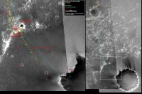
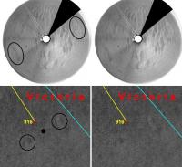
Since there has been some uncertainty about recent positions, I thought I should explain my 916 location. This is how I arrived at it:
This is my 916 polar and part of Tesheiner's map. The circled features indicate the rover location - as I see it. These identifications are always a bit suspect. I haven't done 917 yet. Phil -------------------- ... because the Solar System ain't gonna map itself.
Also to be found posting similar content on https://mastodon.social/@PhilStooke Maps for download (free PD: https://upload.wikimedia.org/wikipedia/comm...Cartography.pdf NOTE: everything created by me which I post on UMSF is considered to be in the public domain (NOT CC, public domain) |
|
|
|
|
|
|
Aug 24 2006, 02:05 AM
Post
#1827
|
|
|
Member Group: Members Posts: 307 Joined: 16-March 05 Member No.: 198 |
I notice that JPL's website have updated their maps of Opportunity's progress as far as Sol 914.
====== Stephen |
|
|
|
|
Aug 24 2006, 07:21 AM
Post
#1828
|
|
|
Senior Member Group: Moderator Posts: 4279 Joined: 19-April 05 From: .br at .es Member No.: 253 |
QUOTE (Phil Stooke @ Aug 24 2006, 03:23 AM) This is my 916 polar and part of Tesheiner's map. The circled features indicate the rover location - as I see it. These identifications are always a bit suspect. I haven't done 917 yet. Nice match, Phil. And when comparing your estimation with the one I've got measuring headings to Epsilon and VC rim features (see red heading lines on this previous post) it looks they fit quite well. That seems to be the right position for sol 916. For 917, I have a "preliminary" correction based on headings (references are Epsilon and Hawking) and it places the rover about 32m SE of the position plotted on my last route map update. It looks like we'll reach Epsilon in two sols (919?), then it will be time to "fine tune" the whole route segment since sol 914. |
|
|
|
|
Aug 24 2006, 12:36 PM
Post
#1829
|
|
|
Senior Member Group: Members Posts: 2998 Joined: 30-October 04 Member No.: 105 |
QUOTE I'm curious as to what software you're using to do the overlays. Photoshop? Or something custom? I use Paintshop Pro (PSP), which is full-featured and reasonably-priced. They have a website, and I think that you can download a demo version for evaluation. --Bill -------------------- |
|
|
|
|
Aug 24 2006, 12:51 PM
Post
#1830
|
|
|
Founder Group: Chairman Posts: 14432 Joined: 8-February 04 Member No.: 1 |
|
|
|
|
|

|
Lo-Fi Version | Time is now: 25th April 2024 - 11:17 AM |
|
RULES AND GUIDELINES Please read the Forum Rules and Guidelines before posting. IMAGE COPYRIGHT |
OPINIONS AND MODERATION Opinions expressed on UnmannedSpaceflight.com are those of the individual posters and do not necessarily reflect the opinions of UnmannedSpaceflight.com or The Planetary Society. The all-volunteer UnmannedSpaceflight.com moderation team is wholly independent of The Planetary Society. The Planetary Society has no influence over decisions made by the UnmannedSpaceflight.com moderators. |
SUPPORT THE FORUM Unmannedspaceflight.com is funded by the Planetary Society. Please consider supporting our work and many other projects by donating to the Society or becoming a member. |
|