Galileo images and mosaics of Europa |

  |
Galileo images and mosaics of Europa |
 Mar 12 2013, 03:38 AM Mar 12 2013, 03:38 AM
Post
#121
|
|
 Junior Member  Group: Members Posts: 20 Joined: 9-October 12 Member No.: 6697 |
Wow, Bjorn, that is beautiful! Really makes me want to go through the Galilean imagery and play around. Can't wait to see the final product!
-------------------- |
 |
 
|
|
Mar 13 2013, 07:08 PM
Post
#122
|
|
|
Member Group: Members Posts: 241 Joined: 16-May 06 From: Geneva, Switzerland Member No.: 773 |
Wow, really great job ! A stupid question: is it possible to overlay color data from lower resolution color pictures or are they of too low resolution ?
Thanks again for these amazing pictures. Marc. |
|
|
|
|
Mar 13 2013, 09:03 PM
Post
#123
|
|
 Lord Of The Uranian Rings Group: Members Posts: 798 Joined: 18-July 05 From: Plymouth, UK Member No.: 437 |
That's a lovely mosaic Bjorn: it really highlights some of the very subtle European topography, particularly the arc-like 'trenches' near the terminator.
-------------------- |
|
|
|
|
Dec 8 2013, 09:56 PM
Post
#124
|
|||||||
 IMG to PNG GOD Group: Moderator Posts: 2250 Joined: 19-February 04 From: Near fire and ice Member No.: 38 |
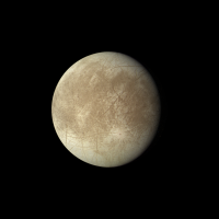
It is well known that Galileo's color coverage of Europa is severly limited. I've been processing all of the Galileo color coverage that is useful for colorizing a huge (16384x8192 pixels) simple cylindrical map of Europa I'm working on. What I'm posting here are some of the more useful images. I'm still working on the well known E14 data so a color mosaic from that is not included. There is also a single 1.2 km/pixel color observation from E12 but it is extremely noisy and I'm not sure I'll get anything useful enough from it.
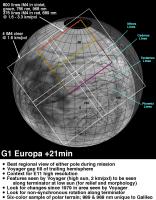
Very early in its mission, during the G1 non-targeted Europa flyby, Galileo obtained the best Europa color coverage of the entire mission in terms of the number of filters used. This is a planning image that appeared on the Galileo website. All of the data was downlinked and without gaps:
As shown above, only about 50% of the red image was downlinked. Fortunately, synthetic red images created from green and 756 nm images are remarkably accurate, the error compared to a real red image is typically ~1% or less. To get true color it's also necessary to create synthetic blue from green and violet. Here is a true color image from red (lower half), synthetic red (upper half), green and synthetic blue:
There is a well known false color image from these Galileo observations that can be seen here. A few more Galileo true (or approximately true) color images, in all cases RGB from an infrared image, green and violet. The G2 image from 968 nm, green and violet images with small gaps in some of the source images filled using data from another filter:
A C9 image from 756 nm, green and violet with small gaps filled as in G2:
A C10 image from 756 nm, green and violet with small gaps filled as in G2:
And finally a G28 image from 756 nm, green and violet. The color in this image is a bit strange and I haven't corrected it. I think the camera's calibration may have changed late in the mission and at least one thing definitely changed. From approximately orbit 26 the images appear less sharp than earlier.
In some cases I posted versions of these image several years ago but these new versions should be significantly better. In particular there is now no pinkish color around Pwyll in the C10 image. And BTW: One unexpected 'discovery' I made while working on these is that a complete set of Galileo SPICE kernels apparently isn't available, for example the frames (FK) kernels are missing. I spent a lot of time searching but without finding a complete set of kernels. This was a big surprise to me. |
||||||
|
|
|
||||||
|
Dec 8 2013, 11:44 PM
Post
#125
|
|
|
Senior Member Group: Members Posts: 2511 Joined: 13-September 05 Member No.: 497 |
QUOTE (Bjorn Jonsson @ Dec 8 2013, 02:56 PM)  a complete set of Galileo SPICE kernels apparently isn't available, for example the frames (FK) kernels are missing...This was a big surprise to me. Galileo predates the frames kernel concept, and it seems likely that no one has been motivated to go back and build them from scratch (we didn't have FKs for most of MGS either, but they were generated in 2007.) Some of that information is in the I kernels for the various Galileo instruments, though I didn't look at the C kernels to understand which frame(s) were in there. Historically image processing was done with the Euler angles in each image file. -------------------- Disclaimer: This post is based on public information only. Any opinions are my own.
|
|
|
|
|
Dec 11 2013, 03:44 AM
Post
#126
|
|
 Junior Member Group: Members Posts: 78 Joined: 29-December 05 Member No.: 623 |
Bjorn,
These are beautiful! There is one more not to forget: a color Europa mosaic on I33. Ted Stryk shows it here: http://planetimages.blogspot.com/2005/09/i...-snapshots.html Cheers, -vexgizmo |
|
|
|
|
Jan 2 2014, 04:32 PM
Post
#127
|
|||||
|
IMG to PNG GOD Group: Moderator Posts: 2250 Joined: 19-February 04 From: Near fire and ice Member No.: 38 |
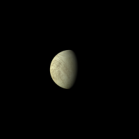
Here is the I33 color image, the range is 1.9 million km. It's from 756 nm, green and violet. As in the G28 image in my previous post the color was probably a bit strange but here I attempted to correct it. I used the C10 color composite as a guide but I still have some doubts about the resulting color. Here the green image has been multiplied by 0.92 and the synthetic blue image by 0.98. The original images were rather blurry so the final image has been sharpened quite a bit:
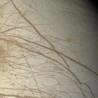
And now two observations from the G7 flyby, one of the better non-targeted Europa flybys. Here is an approximately true color image of Tyre Macula from a distance of 30,000 km. It's created from from 968 nm, green and violet images. This is from AI8 summation mode images so the resolution is ~600 m/pixel. North is up. A fairly well known false color version from the same data can be seen here. But here is the true color image:
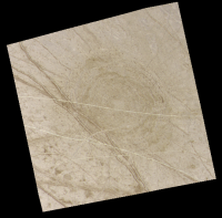
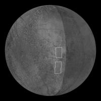
And here is a four frame mosaic from the G7ESAPEXCR observation. The resolution is ~500 m/pixel. Actually this observation consisted of five frames but only a tiny strip of frame three was downlinked. For context, lower resolution data is included. In general this terrain is relatively poorly imaged.
And here is a schematic global view showing the location of the G7ESAPEXCR observation. The subspaccraft longitude is ~115 degrees west. I used a slightly modified version of the USGS Europa map.
Processing the Galileo data can be horribly frustrating. I inevitably start thinking of what could have been. Galileo flew by Europa at a range of 25,000 km during the G7 orbit - and with relatively poorly imaged terrain in view. Under normal circumstances it could easily have imaged this entire terrain at 1 km/pixel or better - and at several wavelengths. Hundreds of images would have been acquired during the G7 Europa flyby. But due to the HGA failure this was not possible, only a tiny part of this terrain was imaged at 1 km/pixel or better. And the reality is that considering how disastrous the HGA loss was, what Galileo managed to do over its mission really was a miracle. |
||||
|
|
|
||||
|
Jan 11 2014, 10:48 PM
Post
#128
|
|
|
Member Group: Members Posts: 241 Joined: 16-May 06 From: Geneva, Switzerland Member No.: 773 |
I love these mosaics of Europa. I just realize that the upper image of the G7ESAPEXCR observation corresponds to the region observed by Galileo NIMS and where clay-like minerals have been detected:
http://www.nasa.gov/jpl/news/europa-clay-l...ml#.UtHIpUrpz7I A big impact structure should be localized just to the east, but no secundaries are visible. I have never seen the SSI and NIMS data associated, may be it would be interesting to superpose them. Regards, Marc. |
|
|
|
|
Jan 12 2014, 04:22 PM
Post
#129
|
|
 Senior Member Group: Members Posts: 2530 Joined: 20-April 05 Member No.: 321 |
Great images, Bjorn.
I wonder if a color model of Europa could be constructed that assumes that the composition (in terms of color, not necessarily chemically), locally, is always at some point on a continuum between icy and non-icy. Then the limited set of color images could be used to model the obviously complex photometry function of both the icy and non-icy terrain, and re-render any B/W images according to that model. It seems like in the case of Europa, a model that simple wouldn't be far from the mark. |
|
|
|
|
Jan 13 2014, 12:38 AM
Post
#130
|
|
|
IMG to PNG GOD Group: Moderator Posts: 2250 Joined: 19-February 04 From: Near fire and ice Member No.: 38 |
QUOTE (MarcF @ Jan 11 2014, 10:48 PM) A big impact structure should be localized just to the east, but no secundaries are visible. There is bright terrain just east of the upper part of the G7ESAPEXCR observation but the resolution there is low and it's not far from the limb in the best images that show it so it's difficult to tell what it is. QUOTE (JRehling @ Jan 12 2014, 04:22 PM) I wonder if a color model of Europa could be constructed that assumes that the composition (in terms of color, not necessarily chemically), locally, is always at some point on a continuum between icy and non-icy. Then the limited set of color images could be used to model the obviously complex photometry function of both the icy and non-icy terrain, and re-render any B/W images according to that model. It seems like in the case of Europa, a model that simple wouldn't be far from the mark. Interesting idea - this might work. The darker terrain is usually redder but it would probably be difficult not to confuse topographic shading with albedo variations unless the solar elevation angle is high (i.e. there are no shadows). It has occurred to me to 'cheat' (either manually in Photoshop or semi-automatically somehow) when colorizing hi-res B/W data with low-res color data. The problem is that the more reddish color of the narrow 'bands' can 'spill' into the adjacent bright terrain if there is a very big difference in resolution. This problem is especially severe in the leading hemisphere where I have to use the 12 km/pixel C9 data to colorize the 1 km/pixel I25 data. |
|
|
|
|
Jan 13 2014, 08:09 PM
Post
#131
|
|
 Senior Member Group: Members Posts: 1627 Joined: 5-March 05 From: Boulder, CO Member No.: 184 |
I've had fairly reasonable results in the past combining low res color (from Bjorn) and hi-res black and white as can be recalled here:
http://laps.noaa.gov/albers/sos/sos.html#EUROPA I've been thinking of redoing this mosaic if I can easily obtain the latest 8K or even higher USGS map of Europa. I understand the bleeding potential though. I wonder if somehow a local color table can be constructed to help with this, if you catch my drift. I'm not really that familiar with fancier methods of colorizing. Steve -------------------- Steve [ my home page and planetary maps page ]
|
|
|
|
|
Jan 15 2014, 12:08 AM
Post
#132
|
|
|
IMG to PNG GOD Group: Moderator Posts: 2250 Joined: 19-February 04 From: Near fire and ice Member No.: 38 |
QUOTE (scalbers @ Jan 13 2014, 08:09 PM) I've been thinking of redoing this mosaic if I can easily obtain the latest 8K or even higher USGS map of Europa. A 500 m/pixel (19631 x 9816 pixels) version is available at the USGS website and it should be geometrically very accurate. Interestingly, it doesn't include some observations that could have been used to increase the resolution in some parts of the map, for example the 14ESTYREHR01 and 14ESWEDGES01 observations and some of the G7 observations. I'm using all of these in the map I'm working on (which has now grown to 20000 x 10000 pixels). In total I expect to use approximately 200 Galileo and Voyager images. |
|
|
|
|
Jan 18 2014, 09:53 PM
Post
#133
|
|
|
Member Group: Members Posts: 890 Joined: 18-November 08 Member No.: 4489 |
-- this is BASED on the USGS map
if all you want there is a 8192x4096 color map in my celestia add on http://www.celestiamotherlode.net/creators...pa_2k_4k_8k.zip or if you do not mind untilling the 16384x8192 color map ( it is chopped into 512x512 px. tiles) http://www.celestiamotherlode.net/creators...paLevel_4P1.zip http://www.celestiamotherlode.net/creators...paLevel_4P2.zip http://www.celestiamotherlode.net/catalog/...p?addon_id=1176 if needed i could post a full sized image on my google drive |
|
|
|
|
Jan 20 2014, 03:08 PM
Post
#134
|
|
 Member Group: Members Posts: 495 Joined: 12-February 12 Member No.: 6336 |
@JohnVV: Once again I get reminded how much this moon cries out for exploration. At least for full mapping at decent resolution.
Just imagine a surface formed by the convection by warm and colder ice! In the areas where we got high resolution one can see some craters after all, the rate somewhat similar to Triton. Though the process that is thought to have eradicated craters on the latter is thought to have been transient yet quite dramatic. Meaning that the less obvious multi-ring impact features on both look similar at first glance yet do so for somewhat different reasons. So thank you for your work, including Bjorn Jonsson / scalbers of course also-it is good to have until we will have a mission to Europa. ( Since one orbiter for Triton is not even in the pipedram stage - unless we make a collective effort here to hijack BepiColombo.  ) )
|
|
|
|
|
Feb 11 2014, 09:30 PM
Post
#135
|
||
|
IMG to PNG GOD Group: Moderator Posts: 2250 Joined: 19-February 04 From: Near fire and ice Member No.: 38 |
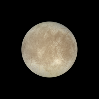
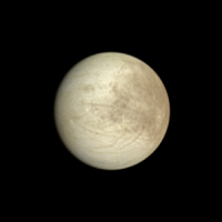
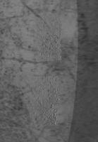
An approximately true color composite from 756 nm, green and violet. This is from images obtained during the E12 orbit.
Not exactly impressive but the source data is extremely noisy and getting rid of all of the noise is difficult without losing lots of details, especially in the narrow ridges near the terminator. The source images were obtained at a range of 135,000 km on December 16, 1997. North is up and the resolution is 1.4 km/pixel. The crater Pwyll is the dark spot above center and the western end of Agenor Linea is visible at lower right. |
|
|
|
|
|
|

|
Lo-Fi Version | Time is now: 23rd April 2024 - 03:18 PM |
|
RULES AND GUIDELINES Please read the Forum Rules and Guidelines before posting. IMAGE COPYRIGHT |
OPINIONS AND MODERATION Opinions expressed on UnmannedSpaceflight.com are those of the individual posters and do not necessarily reflect the opinions of UnmannedSpaceflight.com or The Planetary Society. The all-volunteer UnmannedSpaceflight.com moderation team is wholly independent of The Planetary Society. The Planetary Society has no influence over decisions made by the UnmannedSpaceflight.com moderators. |
SUPPORT THE FORUM Unmannedspaceflight.com is funded by the Planetary Society. Please consider supporting our work and many other projects by donating to the Society or becoming a member. |
|