Perseverance - Early Drives, Sols 14-72 |

  |
Perseverance - Early Drives, Sols 14-72 |
 Mar 7 2021, 12:05 PM Mar 7 2021, 12:05 PM
Post
#31
|
||
 Senior Member  Group: Members Posts: 2425 Joined: 30-January 13 From: Penang, Malaysia. Member No.: 6853 |
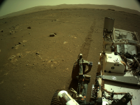
Sol 16, another drive
 L-Navcam looking back at the latest set of wheel tracks on Mars... L-Navcam looking back at the latest set of wheel tracks on Mars...
|
|
 |
 
|
|
|
Mar 7 2021, 12:16 PM
Post
#32
|
||
|
Member Group: Members Posts: 180 Joined: 31-January 05 From: Brittany (France) Member No.: 164 |
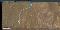
after the last sol 16 drive, Perseverance seems to be located here (marked on a mastcam Z sol 11 image)
-------------------- Erwann |
|
|
|
|
|
|
Mar 7 2021, 02:00 PM
Post
#33
|
||
|
Member Group: Members Posts: 102 Joined: 12-August 12 Member No.: 6540 |
Looks like the rover took a right turn during its Sol 16 drive:
https://mars.nasa.gov/mars2020/mission/where-is-the-rover/ |
|
|
|
|
|
|
Mar 7 2021, 04:34 PM
Post
#34
|
|
 Member Group: Members Posts: 290 Joined: 29-December 05 From: Ottawa, ON Member No.: 624 |
If you've noticed the weird donut-shaped raw images on the Skycam, here is a great link on how it works.
https://www.hou.usra.edu/meetings/lpsc2020/eposter/2282.pdf |
|
|
|
|
Mar 7 2021, 06:40 PM
Post
#35
|
|
|
Merciless Robot Group: Admin Posts: 8783 Joined: 8-December 05 From: Los Angeles Member No.: 602 |
New helicopter thread established.
-------------------- A few will take this knowledge and use this power of a dream realized as a force for change, an impetus for further discovery to make less ancient dreams real.
|
|
|
|
|
Mar 7 2021, 09:15 PM
Post
#36
|
||
|
Solar System Cartographer Group: Members Posts: 10146 Joined: 5-April 05 From: Canada Member No.: 227 |
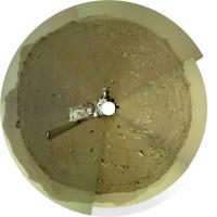
I am still trying to understand the Navcam geometry well enough to make panoramas. I put together a very simple one for sol 16 - horizon tier only - at low resolution. It's not perfect (not good enough to post) but good enough to make a circular view to check the sol 16 location on a HiRISE image. Only 5 Navcams are needed for a full panorama like this. It will be nice to see proper panoramas from our experts.
Phil
-------------------- ... because the Solar System ain't gonna map itself.
Also to be found posting similar content on https://mastodon.social/@PhilStooke NOTE: everything created by me which I post on UMSF is considered to be in the public domain (NOT CC, public domain) |
|
|
|
|
|
|
Mar 7 2021, 09:47 PM
Post
#37
|
||
|
Member Group: Members Posts: 180 Joined: 31-January 05 From: Brittany (France) Member No.: 164 |
QUOTE (Phil Stooke @ Mar 7 2021, 10:15 PM)  I am still trying to understand the Navcam geometry well enough to make panoramas. I put together a very simple one for sol 16 - horizon tier only - al low resolution. It's not perfect (not good enough to post) but good enough to make a circular view to check the sol 16 location on a HiRISE image. Only 5 Navcams are needed for a full panorama like this. It will be nice to see proper panoramas from our experts. Phil Phil, it is good enough to refine the previous location i gave for sol 16 drive
-------------------- Erwann |
|
|
|
|
|
|
Mar 8 2021, 01:31 AM
Post
#38
|
|
|
Member Group: Members Posts: 248 Joined: 25-February 21 From: Waltham, Massachussetts, U.S.A. Member No.: 8974 |
Odometer
https://mars.nasa.gov/mmgis-maps/M20/Layers...0_traverse.json has the traverse geojson data which are used on the Where is Perseverance ? map. The json data also include distances traveled per leg. In addition, it is possible to determine travel distance by measuring along the provided coordinates. Here is a table: CODE day: geojson measured sol 14: 6.25 6.38 sol 15: 36.39 36.53 sol 16: 27.43 28.78 All in meters. There is a small difference and I am not sure why. In any case, total travel sofar is 70m to 72m. -------------------- --
Andreas Plesch, andreasplesch at gmail dot com |
|
|
|
|
Mar 8 2021, 03:00 AM
Post
#39
|
|
|
Member Group: Members Posts: 362 Joined: 13-April 06 From: Malta Member No.: 741 |
Has it been decided where to send the rover on a north or south route?
|
|
|
|
|
Mar 8 2021, 04:12 AM
Post
#40
|
|
|
Solar System Cartographer Group: Members Posts: 10146 Joined: 5-April 05 From: Canada Member No.: 227 |
No. Helicopter operations come before the main traverse.
Phil -------------------- ... because the Solar System ain't gonna map itself.
Also to be found posting similar content on https://mastodon.social/@PhilStooke NOTE: everything created by me which I post on UMSF is considered to be in the public domain (NOT CC, public domain) |
|
|
|
|
Mar 8 2021, 10:58 AM
Post
#41
|
|
|
Senior Member Group: Members Posts: 2425 Joined: 30-January 13 From: Penang, Malaysia. Member No.: 6853 |
QUOTE (Andreas Plesch @ Mar 8 2021, 09:31 AM) Andreas, Nice link for the traverse path JSON. Many thanks I notice your animated traverse that you show elevation of the terrain around the rover. Perseverance elevation data is not available in the M20 interactive map geojson files, so I was wondering if you are aware of any external links to the other M20 traverse values such as pitch, roll etc values and especially elevation at each coordinate change that is made available in the Curiosity Rover interactive map geojson files? Elevation is not hugely interesting in this near flat plain, but it will be of great interest as the rover begins to climb onto the delta and beyond. Any links would be very welcome. regards, Paul |
|
|
|
|
Mar 8 2021, 03:24 PM
Post
#42
|
|
|
Member Group: Members Posts: 248 Joined: 25-February 21 From: Waltham, Massachussetts, U.S.A. Member No.: 8974 |
QUOTE (PaulH51 @ Mar 8 2021, 05:58 AM) Andreas, Nice link for the traverse path JSON. Many thanks I notice your animated traverse that you show elevation of the terrain around the rover. Perseverance elevation data is not available in the M20 interactive map geojson files, so I was wondering if you are aware of any external links to the other M20 traverse values such as pitch, roll etc values and especially elevation at each coordinate change that is made available in the Curiosity Rover interactive map geojson files? Elevation is not hugely interesting in this near flat plain, but it will be of great interest as the rover begins to climb onto the delta and beyond. Any links would be very welcome. regards, Paul The Where is the rover map uses a few more geojson files, see http://www.unmannedspaceflight.com/index.p...st&p=250647 . The way points geojson has yaw, pitch roll data. I just learned about the PDS PLACES database: http://www.unmannedspaceflight.com/index.p...st&p=250716 I think the geojson comes directly from there. There should be elevation (or Z data) but it is not provided in the geojson. I use the 1m HiRISE mosaic DEM linked from: https://astrogeology.usgs.gov/search/map/Ma...tTs0_lon0_first for querying elevation. The DEM and the imagery should be very well co-registered. In my animated traverse due to slight 3d perspective viewing the rover appears a little offset from the traverse since it is offset above ground level. If the geojson included elevation, I could use that as well. Regarding the odometer data, the distances from the geojson may be straight from the rover, using wheel rotations although the coordinates may also be straight from the rover (with subsequent conversion to latitude/longitude). I used projected, equirectangular coordinates to measure distances which is strictly speaking not quite correct but probably still ok at 18 degrees latitude. In any case, it could not explain a >1m discrepancy in distances. Perhaps the geojson distance is the straight line distance between way points, not along the path but this is inconsistent with the last leg which is almost perfectly straight and has the largest difference. -------------------- --
Andreas Plesch, andreasplesch at gmail dot com |
|
|
|
|
Mar 8 2021, 08:04 PM
Post
#43
|
||
|
Member Group: Members Posts: 102 Joined: 12-August 12 Member No.: 6540 |
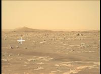
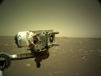
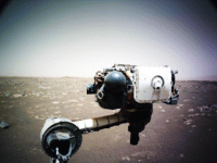
The Sol 17 raw images are online. There's a lot of images of the robotic arm.
Here's a good image of the business end of the arm, the coring drill, framed by a Martian landscape:
|
|
|
|
|
|
|
Mar 9 2021, 12:57 AM
Post
#44
|
||
|
Senior Member Group: Members Posts: 2425 Joined: 30-January 13 From: Penang, Malaysia. Member No.: 6853 |
Looks like we have arrived at a candidate Helipad. This posted on social media.
QUOTE Ive continued driving to scout a spot where Ill drop off the Mars Helicopter, if the area gets certified as a flight zone. So far, about 230 feet (70 meters) of wheel tracks behind me.
|
|
|
|
|
|
|
Mar 9 2021, 01:08 AM
Post
#45
|
||
|
Member Group: Members Posts: 248 Joined: 25-February 21 From: Waltham, Massachussetts, U.S.A. Member No.: 8974 |
The arm got a workout for each axis. Click to animate:
has a color equalize for each frame (the blueish sky is not real). -------------------- --
Andreas Plesch, andreasplesch at gmail dot com |
|
|
|
|
|
|

|
Lo-Fi Version | Time is now: 20th April 2024 - 03:59 AM |
|
RULES AND GUIDELINES Please read the Forum Rules and Guidelines before posting. IMAGE COPYRIGHT |
OPINIONS AND MODERATION Opinions expressed on UnmannedSpaceflight.com are those of the individual posters and do not necessarily reflect the opinions of UnmannedSpaceflight.com or The Planetary Society. The all-volunteer UnmannedSpaceflight.com moderation team is wholly independent of The Planetary Society. The Planetary Society has no influence over decisions made by the UnmannedSpaceflight.com moderators. |
SUPPORT THE FORUM Unmannedspaceflight.com is funded by the Planetary Society. Please consider supporting our work and many other projects by donating to the Society or becoming a member. |
|