Help with an LRO image |

  |
Help with an LRO image |
 Dec 12 2012, 03:15 AM Dec 12 2012, 03:15 AM
Post
#1
|
|
|
Newbie  Group: Members Posts: 17 Joined: 6-July 07 Member No.: 2698 |
Is there a way of getting this link without the gridlines? I have looked at NASA LRO site, the ASU LRO site and the Planetary Photojournal.
Am I missing something? |
 |
 
|
|
Dec 12 2012, 05:02 AM
Post
#2
|
|
 Administrator Group: Admin Posts: 5172 Joined: 4-August 05 From: Pasadena, CA, USA, Earth Member No.: 454 |
Is that part of the global WAC mosaic? http://wms.lroc.asu.edu/lroc/global_produc...0_mpp_global_bw
Edit: no, it's not, I found the original image at the LROC site and I realize it's higher-phase than the global mosaic. What you need to do is to go here: http://wms.lroc.asu.edu/lroc Zoom in to the area around Tycho, then click the "Toggle Layers" button to turn on the WAC layers. Then be patient; it takes a while for the site to retrieve the footprints. Then download data to your heart's content. I haven't messed with WAC data before; I think it's a weird different format from NAC data. I'm not sure if IMG2PNG can convert it or not. -------------------- My website - My Patreon - @elakdawalla on Twitter - Please support unmannedspaceflight.com by donating here.
|
|
|
|
|
Dec 12 2012, 07:02 AM
Post
#3
|
|
|
Senior Member Group: Members Posts: 2511 Joined: 13-September 05 Member No.: 497 |
QUOTE (elakdawalla @ Dec 11 2012, 10:02 PM)  Zoom in to the area around Tycho, then click the "Toggle Layers" button to turn on the WAC layers... Then download data to your heart's content. As far as I can tell, this gets you to the raw pushframe data, which is going to be a little tricky to work with. It seems only the global WAC mosaic has been archived, not any regionals at different phase angles. I'd email ASU and ask. -------------------- Disclaimer: This post is based on public information only. Any opinions are my own.
|
|
|
|
|
Dec 12 2012, 03:42 PM
Post
#4
|
||
|
Solar System Cartographer Group: Members Posts: 10151 Joined: 5-April 05 From: Canada Member No.: 227 |
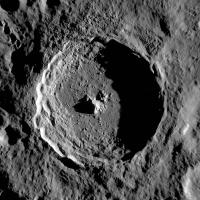
You mean like this? (I can email a less compressed version) Phil -------------------- ... because the Solar System ain't gonna map itself.
Also to be found posting similar content on https://mastodon.social/@PhilStooke Maps for download (free PD: https://upload.wikimedia.org/wikipedia/comm...Cartography.pdf NOTE: everything created by me which I post on UMSF is considered to be in the public domain (NOT CC, public domain) |
|
|
|
|
|
|
Dec 12 2012, 11:47 PM
Post
#5
|
|
 IMG to PNG GOD Group: Moderator Posts: 2250 Joined: 19-February 04 From: Near fire and ice Member No.: 38 |
QUOTE (elakdawalla @ Dec 12 2012, 05:02 AM) [snip] I haven't messed with WAC data before; I think it's a weird different format from NAC data. I'm not sure if IMG2PNG can convert it or not. IMG2PNG correctly converts the WAC data into something recognizable but yes, the format is weird and a bit more complicated to convert than most of the other data IMG2PNG can convert. |
|
|
|
|
Dec 13 2012, 02:55 PM
Post
#6
|
|
|
Solar System Cartographer Group: Members Posts: 10151 Joined: 5-April 05 From: Canada Member No.: 227 |
People who are interested in using WAC images might like this site:
http://moonscience.yolasite.com/lroc-wac.php It contains a gallery of processed WACs, many with spectaular low angle lighting. But in the text at the top of the gallery page, look at the link for a software utility to process the raw data. Phil -------------------- ... because the Solar System ain't gonna map itself.
Also to be found posting similar content on https://mastodon.social/@PhilStooke Maps for download (free PD: https://upload.wikimedia.org/wikipedia/comm...Cartography.pdf NOTE: everything created by me which I post on UMSF is considered to be in the public domain (NOT CC, public domain) |
|
|
|
|
Dec 14 2012, 04:09 PM
Post
#7
|
||
|
Newbie Group: Members Posts: 17 Joined: 6-July 07 Member No.: 2698 |
QUOTE (Phil Stooke @ Dec 12 2012, 09:42 AM)
You mean like this? (I can email a less compressed version) Phil Phil, That is exactly what I was looking for. Thanks Again! |
|
|
|
|
|
|
Dec 14 2012, 06:54 PM
Post
#8
|
|
|
Solar System Cartographer Group: Members Posts: 10151 Joined: 5-April 05 From: Canada Member No.: 227 |
If anyone is interested, I did not have access to the unannotated image. I just stripped out the grid using Photoshop and a bit of magic.
Phil -------------------- ... because the Solar System ain't gonna map itself.
Also to be found posting similar content on https://mastodon.social/@PhilStooke Maps for download (free PD: https://upload.wikimedia.org/wikipedia/comm...Cartography.pdf NOTE: everything created by me which I post on UMSF is considered to be in the public domain (NOT CC, public domain) |
|
|
|
|

|
Lo-Fi Version | Time is now: 26th April 2024 - 11:07 AM |
|
RULES AND GUIDELINES Please read the Forum Rules and Guidelines before posting. IMAGE COPYRIGHT |
OPINIONS AND MODERATION Opinions expressed on UnmannedSpaceflight.com are those of the individual posters and do not necessarily reflect the opinions of UnmannedSpaceflight.com or The Planetary Society. The all-volunteer UnmannedSpaceflight.com moderation team is wholly independent of The Planetary Society. The Planetary Society has no influence over decisions made by the UnmannedSpaceflight.com moderators. |
SUPPORT THE FORUM Unmannedspaceflight.com is funded by the Planetary Society. Please consider supporting our work and many other projects by donating to the Society or becoming a member. |
|