Printable Version of Topic
Click here to view this topic in its original format
Unmanned Spaceflight.com _ Cassini's ongoing mission and raw images _ Iapetus Far-Encounter between March 25 and April 18 2006
Posted by: TritonAntares Mar 14 2006, 01:04 PM
First of all, again the two existing encounter animations:
http://www.mmedia.is/bjj/misc/css_stuff/misc/iapetus_jan2006.avi
http://www.greuti.ch/cassini/japetus_april.avi
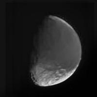
Nearest approach: 
Resolution about 3,6 km/pxl.
And some pre-info about upcoming encounters:
2006 Mar 25 to Apr 18: Apr 11 - 602.412 km; 14-3.6 km/pxl; medium to high phase, southern hemisphere as crescent
2006 Jun 17 to 27: Jun 23 - 1.343.000 km; 14-8.1 km/pxl; medium to low phase, sub-Saturn hemisphere
2006 Sep 08 to 09: Sep 02 - 1.816.000 km; ~20 km/pxl; zero phase (3 to 0.05 deg), sub-Saturn
2006 Nov 26: 1.997.000 km; 12 km/pxl; very low phase, sub-Saturn
2007 Feb 12 to 15: Feb 14 - 2.249.000 km; ~14 km/pxl; sub-Saturn; very low phase and eclipse
2007 Apr 14: 2.256.000 km
2007 Jun 22: 1.817.000 km; ~14 km/pxl; med. phase, trailing side
2007 Sep 03 to 09: 8.6-0.7 km/pxl; very high phase, western Cassini Regio
2007 Sep 10: 480-10-540 m/pxl; targeted flyby, trailing side
2007 Sep 11 to 17: 0.7-7.1 km/pxl; low phase (~33 deg) trailing side
2007 Sep 27: 15 km/pxl, low phase sub-Saturn+trailing side
2007 Nov 26: 1.371.000 km; 8.2 km/pxl; very high phase, north pole, possibly graylight
2008 Feb 13: 2.045.000 km; 14 km/pxl; high phase, north pole, possibly graylight
Days around Sep 10 belong to the targeted fly-by in about 1000 km distance,
others will only be some OPNAVs.
Bye.
Posted by: TritonAntares Mar 17 2006, 10:28 AM

http://www.mmedia.is/bjj/misc/css_stuff/misc/iapetus_jan2006.avi
http://www.greuti.ch/cassini/japetus_april.avi
...
I've forgotten a third one:
http://www.unmannedspaceflight.com/index.php?act=Attach&type=post&id=3841
Not so nice concerning the drawn textures, but showing dates and distance data.
I've tried to create an additional one with 'Celestia', but I came in trouble with zooming in from Cassini to Iapetus.


Also I did a mistake in using Steve Albers latest map. It's centered on 0°, not on 180° as 'Celestia' wants.
So I was quite surprised in seeing the equatorial ridge with its white mountains in prime focus at end of this month...


Is anyone able to convert it into the 180° seight? 1024 x 512 pixels would be sufficient.
Alternativly is this map from December:
|
'Terra incognita' is shown in black...
but not so nice as Steves' map.
Thx and Bye.
Posted by: angel1801 Mar 17 2006, 01:16 PM
http://www.unmannedspaceflight.com/index.php?act=Attach&type=post&id=3841
Not so nice concerning the drawn textures, but showing dates and distance data.
I've tried to create an additional one with 'Celestia', but I came in trouble with zooming in from Cassini to Iapetus.
Also I did a mistake in using Steve Albers latest map. It's centered on 0°, not on 180° as 'Celestia' wants.
So I was quite surprised in seeing the equatorial ridge with its white mountains in prime focus at end of this month...
Is anyone able to convert it into the 180° seight? 1024 x 512 pixels would be sufficient.
Alternativly is this map from December:
|
|
'Terra incognita' is shown in black...
but not so nice as Steves' map.
Thx and Bye.
I (out of interest as "Celestia" is referenced here alot), decided to download it. I was not happy with the textures they used for Saturn's moons, so I decided to use Steve Albers maps. And I can get them to work.
Here's how. Copy his maps to the "textures --> hires" folder and remove anything after the body's name on the file name. ie "Tethys_www_cyl_rgb" to just "Tethys". Do the same for all the other "Hires" textures. When you load Celestia, choose "Hires" mode and select the maps you have just loaded.
And to solve the problem with the maps being centered at 180W reather than 0W, just do a mental calculation to adjust for the problem.
ie To have the "The Great White Splat" (12S, 111W) centered on a Rhea Map, select -12 for latitide and 69 for longitude.
69 = -111 (=111W longitude) + 180
Another example "Tirawa" centered Rhea,
Latitude = 34.8 (34.8N)
Longitude = 28 (-152 + 180) [-152 = 152W]
Again using Rhea, "Evil Twin" (10N, 180W) would be imput as +10 latitude and 0 longitude.
I have collected a wonderful collection of Saturn's moons and and a variety of views. I have got polar views (centered on both north and south poles) for all of Saturn's moons that I have a good map for (provided by Steve Albers of course!)
Of course, the pole centered maps need no adjustment.
ie Dione centered 90N and 0W is simply entered unadjusted.
90 for latitude and any input longitude.
I hope this helps you.
Posted by: scalbers Mar 17 2006, 07:24 PM
Hi all,
It's true I use a map convention that's 180 degrees offset from Celestia. I actually routinely port my map updates into Celestia. To do this I (in a Linux environment) run the 'convert' utility with a "roll" option to offset the map. There may also be a way to make a Celestia animation that can be posted on the web, though it may be a bit tedious. Here are a couple of still images:
http://laps.noaa.gov/albers/sos/saturn/iapetus/iapetus_apr06_1.jpg
http://laps.noaa.gov/albers/sos/saturn/iapetus/iapetus_apr06_2.jpg
Posted by: angel1801 Mar 18 2006, 12:43 PM
It's true I use a map convention that's 180 degrees offset from Celestia. I actually routinely port my map updates into Celestia. To do this I (in a Linux environment) run the 'convert' utility with a "roll" option to offset the map. There may also be a way to make a Celestia animation that can be posted on the web, though it may be a bit tedious. Here are a couple of still images:
http://laps.noaa.gov/albers/sos/saturn/iapetus/iapetus_apr06_1.jpg
http://laps.noaa.gov/albers/sos/saturn/iapetus/iapetus_apr06_2.jpg
Is there a "roll" option for those who use Celestia only on Microsoft Windows? Can you write a script
in Celestia for Windows to compersate for it?
Posted by: helvick Mar 18 2006, 02:29 PM
in Celestia for Windows to compersate for it?
I don't think celestia can do this itself but you can also do this with any graphics editor that can load the files - just carefully split it in two and rejoin by hand.
I have a short Perl GD script that I can post that does it but you'd need Perl with the GD module installed for it to be of any use to you.
Posted by: scalbers Mar 18 2006, 02:54 PM
Angel1801,
It turns out that the 'convert' utility is independent of Celestia, so I simply run this prior to copying the file into my Celestia directory. Perhaps there's a similar utility available in the Windows environment, within Photoshop or something like that?
Another option is that I might be able to mirror some of my Celestia map versions to a web-accessable directory. Hopefully the disk space would be reasonable, though if that were an issue I could always run my 2-week purger on it (relative to when I update a given image). I'll think about this some more over the next few days.
Posted by: Phil Stooke Mar 18 2006, 06:27 PM
If you need to switch between maps centred at 0 and 180 longitude, the process is trivial in any image editing software like Photoshop. I would simply select the whole map, copy it and paste it over itself twice. One copy I push out half-way to the left, one half-way to the right, then zoom in and make sure they are exactly lined up with each other and with the middle column of pixels. Flatten and save.
Phil
Posted by: um3k Mar 19 2006, 04:51 AM
Phil
You can also use the "offset" filter. Just set it to offset it 1/2 the pixel width of the image to the right. (I hope that made sense. I'm a bit tired.)
Posted by: edstrick Mar 19 2006, 12:24 PM
I flipped the meridians in an Iapetus map a while back in photoshop by using the "Image / Canvas Size" command: I reduce the image by half horizontally, cropping the right side and saving the file as "left". I reload the image and then repeat the process, cropping the left side, saving it (for safety) as "right". I re-size the canvas to enlarge the right, open select and copy the "left" image and paste it in the blank "right" area. Probably need to "flatten" the composite image.
I've never figured out how to use layers and stuff worth a damn. Lazy.
Posted by: TritonAntares Mar 19 2006, 06:59 PM
Many thanks for the advices on converting the Iapetus-map from 0° to 180° center.
I will try when time allows...
Back to Iapetus...
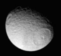
...I found these two 'old' Cassini images back from July 19, 2004:

|
Distance: ~ 2.9 Mio. km
Resolution: 17 km/pxl
A first hint on what we'll see in the upcoming far-encounter.
Visible is the bright southern rim of the big bassin in eastern CR
and the polar region with a large amount of craters below.
Actually what is the dark curved structure parallel to the terminator?
The eastern rim of another big bassin?
There also seems to be a greater structure - possibly a crater - left to the terminator south of this dark bow.
Bye.
Posted by: scalbers Mar 20 2006, 08:31 PM
Interesting images from back in 2004. I'll have to see whether they add any details beyond what I have in the map.
I have also placed some Celestia compatable versions of the Iapetus map on the web at this URL:
http://laps.noaa.gov/albers/sos/celestia
Posted by: TritonAntares Mar 20 2006, 11:03 PM
I tried this...
and easy going!
Here are 3 animations for the upcoming far-encounter using this texture:
Mar 25 to 31:
 iapetus_a.avi.html ( 215.5K )
: 1608
iapetus_a.avi.html ( 215.5K )
: 1608Apr 01 to 12:
iapetus_b.avi.html ( 425K )
: 1315Apr 12 to 18:
iapetus_c.avi.html ( 272K )
: 1320Just remove *.html and run the avi-files.
I prefer running them on a DIVX-player.
Bye.
Posted by: tedstryk Mar 22 2006, 09:27 PM
I will try when time allows...
Back to Iapetus...
...I found these two 'old' Cassini images back from July 19, 2004:
|
|
Distance: ~ 2.9 Mio. km
Resolution: 17 km/pxl
Yes...that is a sequence from slightly farther out than the one I used to make this super-res view I posted a while back.
http://img97.imageshack.us/my.php?image=iapapproach6hl5fn.jpg
Posted by: TritonAntares Mar 23 2006, 10:33 AM
The first Iapetus image of the upcoming far-encounter has been released by NASA/JPL:
Here an enlarged part: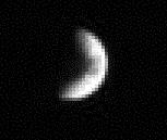
Date: March 16, 2006
Distance: 5.247.271 km (!)
Filters: CL1 & CL2
Enlargement: 3x
Don't know why they took it, probably an OPNAV.
Maybe they just wanted to know if this strange moon is still there...
... it is. 
Bye.
Posted by: Decepticon Mar 23 2006, 01:55 PM
To lazy to to check, is Iapetus in a proper orbit for saturnshine images?
Posted by: ugordan Mar 23 2006, 02:03 PM
There is no "proper" orbit for saturnshine images. Every orbit will carry the moon over Saturn's dayside eventually, if it's a circular orbit it will do so for half the orbital period. This is the time when the sub-saturnian hemisphere of the moon receives saturnshine. The brightness obviously depends upon distance from Saturn and the phase angle at which Saturn appears.
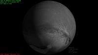
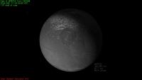
Posted by: TritonAntares Mar 24 2006, 11:25 AM
http://img97.imageshack.us/my.php?image=iapapproach6hl5fn.jpg
I created a simulated Iapetus view with Celestia for Jul 19, 2004:
|
|
Maybe I'll add an animation later.
When actually was your super-res taken?
Bye.
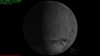
Posted by: tedstryk Mar 24 2006, 02:13 PM
|
|
|
|
Maybe I'll add an animation later.
When actually was your super-res taken?
Bye.
I will have to research that. I lost the work in my computer crash, and I only have the finished product because I posted it to this forum and downloaded it again...Without the original files, I can't say for certain which images I used, although I know I used an entire set and that it was the closest set I could find taken prior to orbit insertion.
Posted by: scalbers Mar 24 2006, 06:56 PM
I did a Celestia run for July 2004 and found that Cassini had a closest approach at about 0900 UT on July 13, and this just about matches Ted's super-res image! I am currently checking to see if this can add detail to my map. This image really does seem to have a lot of detail for 2330000km distance.
Ted, I was unable to spot the original images on the raw images page, so perhaps you had done your processing using PDS images?
Posted by: TritonAntares Mar 24 2006, 10:01 PM
Try this one:
http://saturn.jpl.nasa.gov/multimedia/images/raw/raw-images-details.cfm?feiImageID=7174
...and the following images.
Quite a lot of stuff I've never had a detailed look at...
Bye.
Posted by: Decepticon Mar 27 2006, 01:09 PM
Images stared coming in... http://saturn.jpl.nasa.gov/multimedia/images/raw/casJPGFullS19/N00056025.jpg
Posted by: TritonAntares Mar 27 2006, 02:05 PM
Hi,
yes, the first 18 images arrived.
Here two takeouts:
|
Date: 2006/03/25
Distance: 2.375.054 km
Filters: P60 and GRN
|
Date: 2006/03/26
Distance: 2.325.426 km
Filters: CL1 and CL2
Nothing spectecular, the same side as everytime...
Bye.
Posted by: TritonAntares Mar 28 2006, 06:24 PM
Hi,
another 9 images were published.
Here one takeout: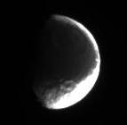
Date: 2006/03/27
Distance: 2.262.603 km
Filters: CL1 and CL2
Bye.
Posted by: TritonAntares Mar 29 2006, 11:26 AM
Hi,
http://www.geoinf.fu-berlin.de/projekte/cassini/cassini_gal_iap.php a Iapetus picture gallery from the German FU-Berlin.
Some images were unpublised until now.
Bye.
Posted by: Decepticon Mar 30 2006, 01:19 AM
Those night side images are just breath taking! 
Posted by: BruceMoomaw Mar 30 2006, 02:41 AM
Keep in mind that they're NOT the nightside; they're the dark side (Iapetus being the only moon that genuinely has one).
Posted by: tedstryk Mar 30 2006, 03:12 AM
Actually, in that series, there are several that are from the Saturnshine coverage.
Posted by: mchan Mar 30 2006, 04:21 AM
Hmm, I had never considered before that Pink Floyd was referring to Iapetus.
Posted by: TritonAntares Mar 30 2006, 07:54 AM
Hi,
ever seen this series?
|
This enormous southern bassin is really remarkable.
Remembers quite a bit of the large craters on Tethys:
|
Left: Melanthius
Right: Odysseus
---------------------------------------------------------------------------------------------------------------------------
Btw, 'Solar System Viewer' is now working with an updated Iapetus texture, finally...

Here five views from CASSINI:
|
|
|
|
|
Pretty improvement...
And one from Saturn today:
|
Luckily sunshine outshines saturnshine today...

Due to its bounded orbit you can recognize the saturnshine side of Iapetus.
Bye.
Posted by: TritonAntares Mar 30 2006, 06:15 PM
Hello,
another 9 images arrived from CASSINI.
Here one takeout:
Date: 2006/03/28
Distance: 2.188.203 km
Filters: CL1 and CL2
Bye.
Posted by: TritonAntares Apr 1 2006, 10:02 AM
Hi,
another 10 far-distance images were taken from Iapetus.
Here one takeout: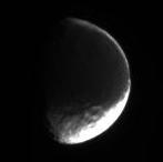
Date: 2006/03/29
Distance: 2.103.960 km
Filters: CL1 and CL2
Bye.
Posted by: Rob Pinnegar Apr 1 2006, 04:20 PM
This distant flyby could turn out to be pretty interesting. There look to be some interesting gradations in the colour of Cassini Regio in Iapetus south-leading quarter-sphere (demihemisphere?).
In a few of those distant shots TritonAntares has posted, you can see some of the bellyband mountains on the limb. Amazing how tall those things are.
Posted by: Michael Capobianco Apr 1 2006, 05:41 PM
I can't see the bellyband, but a few of these shots do show the Moat's central peak very clearly on the limb.
Michael
Posted by: Rob Pinnegar Apr 1 2006, 06:07 PM
Hmmm. You might be right about that one, Michael. I just sort of assumed that the peak on the limb was one of the bellyband peaks. It could very well be the Moat's central peak instead.
Posted by: TritonAntares Apr 1 2006, 08:26 PM
I always wondered about the trace of the bellyband in Iapetus eastern hemisphere.
It's so obvious in Steve Albers map:
|
|
I marked the supposed course of the bellyband in the above mentioned region south of the 'Snowman' of an enlarged map.
The central peak of 'Snowman A' is also encircled.
|
Compare with this image taken on Jan. 22, 2006, at a distance of approximately 1.3 million km:
|
You can easily see the enormous height of the Moat's central mountain.
But there is no hint due shadow casting for large mountains at the marked line of the supposed bellyband path,
but south of it seems to be a huge ridge (ellipse) casting a shadow to NNW like the inner crater rim of 'Snowman A'.
Therefore the bellyband in Iapetus eastern hemisphere must be quite low, if it exists at all
and this line in Steve Albers map is artifical there.
Bye.
Posted by: Michael Capobianco Apr 1 2006, 08:50 PM
[quote name='TritonAntares' date='Apr 1 2006, 03:26 PM' post='48836']
But there is no hint due shadow casting for large mountains at the marked line of the supposed bellyband path,
but south of it seems to be a huge ridge (ellipse) casting a shadow to NNW like the inner crater rim of 'Snowman A'.
Therefore the bellyband in Iapetus eastern hemisphere must be quite low, if it exists at all and this line in Steve Albers map is artifical there.
Yes. Although there is a suggestive bright line there, it seems to be just a coincidence. The ridge you highlight appears to be part of an interesting crosshatching of ridges to the south, although it's very hard to make out what's going on at these low resolutions.
Michael
Posted by: TritonAntares Apr 1 2006, 10:48 PM
Hello!
You mean this mysterious doublecross structure:
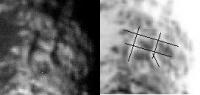
|
What is this?
Tectonic rifts and ridges caused by the 'Snowman'?
Something connected with the equatorial ridge?
Or...?
Bye.
Posted by: scalbers Apr 2 2006, 12:51 AM
Yes I agree the white line on the E edge of CR is a real albedo feature, though maybe a fortituous coincidence. The stereo imagery I had once shown didn't show any conclusive ridge there, though it might not completely be ruled out either. I am starting to reprocess some of the Saturnshine images in the hope of improving the noise reduction and resolution so that might help slightly. If I can add do this and find additional Saturnshine images from that encounter it could help both in the map and the stereo imaging.
The snowcapped peaks on the W side of CR do look more realistic as part of the bellyband.
All this to preface what are an interesting set of images coming in as we speak.
Posted by: Michael Capobianco Apr 2 2006, 03:18 AM
You mean this mysterious doublecross structure:
|
|
What is this?
Tectonic rifts and ridges caused by the 'Snowman'?
Something connected with the equatorial ridge?
Or...?
Tic Tac Toe board?
Michael
Posted by: ugordan Apr 2 2006, 10:34 AM
|
|
What is this?
Tectonic rifts and ridges caused by the 'Snowman'?
Something connected with the equatorial ridge?
Or...?
This reminds me of the discussion on You-Know-What looking hill on Mars that was identified in Viking imagery years ago.
Seems that you're really trying to pull out too much information out of such a low-res view. For all we know, higher resolution might make this nothing like a double-cross.
Even now, that lower horizontal line you marked seems to end in a small crater on the right (you did extend it into the crater itself) , while the upper line follows its outer rim. The right vertical line thus outlines the interior wall of the crater. Human eye often likes to see patterns when there aren't any.
Posted by: TritonAntares Apr 2 2006, 01:15 PM
Seems that you're really trying to pull out too much information out of such a low-res view. For all we know, higher resolution might make this nothing like a double-cross.
Even now, that lower horizontal line you marked seems to end in a small crater on the right (you did extend it into the crater itself) , while the upper line follows its outer rim. The right vertical line thus outlines the interior wall of the crater. Human eye often likes to see patterns when there aren't any.
You're definitely right, these low resolution images lead to misinterpretations. The double-cross is for sure some
artifical structure, pretenced by the human eye.
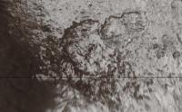
After a 'second look' at the region I could recognize 3 craters (one of them you mentioned), the southern rim of 'Snowman A', the horizontal structure south of it and two vertical structures (parts of the double-cross):
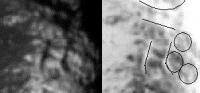
|
Due to dark shadow casting the three structures should be ridges...
Bye.
Posted by: Decepticon Apr 2 2006, 02:07 PM
Raws are up for April 1,2006
Posted by: TritonAntares Apr 2 2006, 06:56 PM
Hi,
yes, the next 18 images arrived.
Here two takeouts:
Date: 2006/03/30
Distance: 2.000.937 km
Filters: CL1 and CL2
Date: 2006/04/01
Distance: 1.867.635 km
Filters: CL1 and CL2
Probably a large mountain visible at the right rim...
CASSINI is slowly getting closer...
Bye.
Posted by: Phil Stooke Apr 3 2006, 02:08 AM
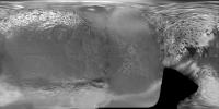
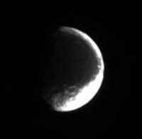
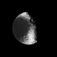
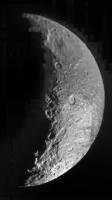
This is the latest view of Iapetus. It's a composite of six images from the latest batch, combined to reduce the JPEG artifacts and with a bit of selective contrast fiddling as well.
Phil
|
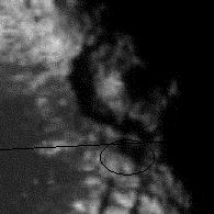
Posted by: Rob Pinnegar Apr 3 2006, 05:23 AM
Hey, what's that white curve-shaped feature near Iapetus' south pole? Have we seen that thing before?
At first glance, and using a bit of imagination, it looks like it could be a partial arc of a basin rim -- and there are some other nearby arc-like features that look as if they are also part of the same structure. However, I can't tell whether my eyes are playing tricks on me, and filling in the rest of the pseudo-rim where I want it to be.
Hard to believe it could actually be a basin -- surely something that large couldn't have been overlooked. What else could it be? Another mountain range perhaps?
Posted by: ugordan Apr 3 2006, 07:17 AM
I believe that's the south polar bright terrain, very overexposed here. We really haven't seen much of it in Cassini's images so far, but the hints in the New Years Eve flyby look like it's much brighter/cleaner ice than the (now well imaged) north pole.
This brightness dichotomy is stressing the ISS S/N ratio to the fullest, the team probably optimized for the Cassini Regio and that's why the south turned out so white. Contrast stretching might have played a role also.
Posted by: Decepticon Apr 3 2006, 12:32 PM
At first glance it looked like a chain of craters?
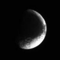
Posted by: Phil Stooke Apr 3 2006, 01:32 PM
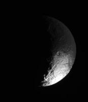
Another view of Iapetus from the latest sequence. Again, it's a stack of six images, each one enlarged, contrast stretched and sharpened.
Phil

|
Posted by: TritonAntares Apr 3 2006, 02:21 PM
At first glance, and using a bit of imagination, it looks like it could be a partial arc of a basin rim -- and there are some other nearby arc-like features that look as if they are also part of the same structure. However, I can't tell whether my eyes are playing tricks on me, and filling in the rest of the pseudo-rim where I want it to be.
Hard to believe it could actually be a basin -- surely something that large couldn't have been overlooked. What else could it be? Another mountain range perhaps?
This seems to be a former unknown structure, or say better a bad resolved one:
Here what is recognizable:

|
Left: part of Steve Albers map
Middle: Phils' stack of six images
Right: part of south polar projection
The white curve-shaped feature near Iapetus' south pole could be a crater chain or even some sort of graben.
Upcoming images will show this region in a better resolution.
Let's wait a few days...
Bye.
Posted by: TritonAntares Apr 3 2006, 03:53 PM
So,
another 10 far-distance images arrived lately.
The takeout:

|
Date: 2006/04/02
Distance: 1.639.462 km
Filters: CL1 and CL2
Bye.
Posted by: TritonAntares Apr 5 2006, 05:05 PM
Hello,
another 11 Iapetus far-distance images have been released lately.
Two takeouts:

|
Date: 2006/04/03
Distance: 1.496.620 km
Filters: CL1 and CL2

|
Date: 2006/04/04
Distance: 1.433.094 km
Filters: CL1 and CL2
Bye.
Posted by: Michael Capobianco Apr 5 2006, 06:16 PM
another 11 Iapetus far-distance images have been released lately.
Bye.
That ridge on the terminator continues to fascinate. It may be another one of those Iapetan anomalies. My prediction: this pass will give us an important new clue to the Iapetus mystery.
Michael
Posted by: BruceMoomaw Apr 6 2006, 12:27 AM
Dennis Matson will have a paper at May's AGU meeting, "Forming Iapetus Equatorial Ridge". He's already stated elsewhere recently (can't quite remember where) that his studies show that, during Iapetus' early days when it was still being heated by its internal aluminum-26, and therefore stretched by its own as-yet fairly rapid rotation, the equatorial bulge is where its mantle's internal convective currents would have converged to upthrust the ridge.
Posted by: Phil Stooke Apr 6 2006, 01:24 AM
The trick then becomes explaining the lack of ridges on other bodies.
Phil

|
Composite of two April 4 images plus a bit of magic.
Posted by: Michael Capobianco Apr 6 2006, 04:03 AM
Actually, I was referring to the little curvilinear ridge visible near the terminator in the latest images. It could just be craters lined up or a basin rim remnant, but you can't tell for sure at this resolution.
As for the equatorial ridge, any theory would also have to explain why it isn't continuous all the way around Iapetus.
Michael
Posted by: Rob Pinnegar Apr 6 2006, 03:02 PM
For what my opinion might be worth, the aluminum-26 hypothesis just can't cut it. Aluminum-26 has a half-life of less than a million years -- it would all have been gone pretty much right after Iapetus finished forming. How the heck could the equatorial ridge have survived, nearly intact, through four and a half billion years of crater formation, with no internal heat source to maintain it?
I guess the counterargument is that, if Iapetus were hot enough to start with, it would have taken a while to cool -- perhaps long enough to keep building the bellyband until after the major phase of crater formation. But is Iapetus big enough to have stayed liquid right through the late heavy bombardment? That's over 700 million years. And then there's Phil's point to consider, as well.
Unfortunately, although attacking this hypothesis is an easy thing to do, coming up with a better idea is a lot more difficult. The "Old Reliable" of internal energy sources -- tidal heating -- probably won't work here because Iapetus is way too far away from Saturn. That's too bad, because it's pretty close to being in a 5:1 resonance with Titan.
Maybe Iapetus' orbit was really, really elliptical a long time ago, and the slow process of circularization provided a long term source of tidal heating? That might explain why there are no other major moons past Hyperion. I'm grabbing at straws here, though... and have no idea if this process would provide even a fraction of the heat that would be required to keep internal circulation going.
This is a real mystery. The moon's overall shape and rugged appearance seem to suggest very rapid freezing. But the bellyband has to be younger than most of the craters which suggests long term internal activity. Strange.
Posted by: tasp Apr 6 2006, 03:03 PM
A thought experiment:
Get a very precise cannon, one that can shoot bowling balls exactly 10 miles when aimed parallel to the surface.
Place the cannon on top of a hill 100 feet high.
Start firing. (you have an unlimited supply of bowling balls)
What happens?
First bowling ball zips out and lands 10 miles away. Second bowling ball hits first bowling ball.
Third, forth, etc.
Eventually, 10 miles away, we get a pile of bowling balls (in the thought experiment, the bowling balls don't break).
Keep firing.
Now what happens?
Kinetic energy of the incoming bowling balls eventually is insufficient to overcome the mass of the pile of already fired bowling balls. At this point, the bowling balls start accumulating on the cannon facing side of the bowling ball pile.
Keep firing.
As more and more bowling balls are fired at the pile, the pile 'grows' into the incoming stream of bowling balls. Fire long enough, and the pile becomes a ridge 'growing' upstream towards the cannon.
Let's change the model a little. Let's now fire the bowling balls at .00001% more than orbital velocity and change our altitude 1 foot higher for the cannon.
Now, the bowling balls make 1 orbit (neglecting air resistance) before an unspecified (at this point) drag force lowers the orbit of the bowling ball 1 foot and the bowling ball smacks the pile.
(note, we lower the cannon every time a bowling ball whizzes by)
Now what happens?
Bowling balls (after orbit decays 1 foot), still smack the pile, bowling balls still have insufficient energy to overcome the inertia of the existing pile, so the bowling balls keep accumulating on the 'upstream' side of the pile.
Let's change the model a little more now.
Let's put the cannon in a much higher orbit and fire zillions of cannon balls.
Cannon balls form a ring structure, very very similar to Saturns.
Cannon balls now have the opprotunity to interact with each other.
Lets's look at a particular cannon ball. As it orbits, it will from time to time, bump a cannon ball in a very slightly lower orbit. This will occur at a very low relative velocity. But it will happen often.
What is the result of the collision? A very small amount of energy will transfer (on average) from the lower bowling ball to the higher bowling ball. As a result, the lower bowling ball orbits a little lower. And the bowling ball above, wants to orbit a little higher.
But it will lightly bump its brethren in the next slightly higher orbit above, transfering energy to them, and itself falling back down to a slightly lower orbit.
This mechanism transfers energy from the low side of our bowling ball rings to the upper side.
The result of this is a very slow, but steady stream of bowling balls to ever lower orbits, at the expense of transfering energy to the upper side of the ring structure.
Eventually, we have a slow dribble of bowling balls smacking the highest point on the surface along their orbital ground track, and accumulating upstream all the while.
What of the bowling balls at the high side?
Possibilty exists that minor drag forces; air resistance if you grant a very small amount it, solar wind perhaps, light pressure, etc. saps enough energy from the system that you can emplace the entire ring structure on the surface without accumulating any material on the 'high side'.
What does our surfaced emplaced ring of bowling balls look like?
Given enough bowling balls, a long ridge!
As to Iapetus, replace 'bowling balls' with 'ice chuncks', and 'cannon' with orbited debris from oblique asteroid impact, and you can see how Iapetus got its ridge.
(time constraints now don't allow me to go into how you get an organized ring system from an impact, but a scientist named Laplace worked it out a couple of centuries ago)
Posted by: TritonAntares Apr 6 2006, 03:13 PM
Hi,
the rest of the April 4th Iapetus image series - 80.000 km closer - is online.
Takeout of 9 shots - I did some gradation tuning:

|
Date: 2006/04/04
Distance: 1.352.785 km
Filters: CL1 and IR3
--------------------------------------------------------------------------------------------------------------------------------------------------------
The curvilinear ridge visible near the terminator in the latest images is obviously connected with a crater doublett,
one elongated crater north of the pair and a larger one south:

|
Thus the ridge could be sunlighted crater rims of those four.
The angle of incoming light is probably fooling us...
But there should be an interesting feature farther south (quadrangle) - maybe a huge mountain.
Looks like one of those mensae found on Io on this Iapetus polarmap.
I'm quite curious what CASSINI images will show there...
Bye.
Posted by: Michael Capobianco Apr 6 2006, 03:19 PM
So we have exogenous and endogenous theories for the equatorial ridge as well.
What kind of observations will it take to sort this out? I guess if the ridge is eruptive, there should certainly be evidence of that in the close-ups in 2007. The white mountains in Western CR might look like cryovolcanoes, forex, or piles of welded cannon balls.
Michael
Posted by: Bob Shaw Apr 6 2006, 03:34 PM
The flaw in the 'bowling ball' theory is that there's no chance of the plane of the orbit of the ring remaining fixed with relation to the surface of the moon, so the decaying ring particles wouldn't hit in a line but rather in a belly-band centered under the average orbital path (which migt well be sinusoidal). Saturn's system would have altogether too many and varied perturbations for the simplistic model to work!
Bob Shaw
Posted by: tasp Apr 6 2006, 05:08 PM
Laplace worked out the scenario for getting all the materials in randomly inclined orbits over the equator long ago.
If you have a copy of The New Solar System, check out the chapter on planetary rings for a more complete description of the collapse of materials to the Laplacian plane.
When I saw that, I knew the equatorial ridge structure had to be the emplaced residue of ring system around Iapetus long ago.
Of all the major satellites in the solar system, Iapetus has the most isolated orbit from perturbing effects.
To anticipate another question, vaporization, the impacting debris on Iapetus would be traveling less than 1550 km/hr. Rather less if one feels Iapetus was rotating more rapidly in the past. (the weak tidal effects of distant Saturn braking Iapetus' primordial rotation would have been uniquely slow)
Posted by: Bob Shaw Apr 6 2006, 05:47 PM
To anticipate another question, vaporization, the impacting debris on Iapetus would be traveling less than 1550 km/hr. Rather less if one feels Iapetus was rotating more rapidly in the past. (the weak tidal effects of distant Saturn braking Iapetus' primordial rotation would have been uniquely slow)
It's the perturbations - the *many* perturbations - which are the fly in the ointment. Yes, rings do tend to become planar, and astonishingly self-organised, but in practice we just don't see them wherever there's anything other than one big(ish) body for the effect to work around.
If Iapetus were anything other than unique I might agree with you, but not this time!
Bob Shaw
Posted by: TritonAntares Apr 6 2006, 07:54 PM
What kind of observations will it take to sort this out? I guess if the ridge is eruptive, there should certainly be evidence of that in the close-ups in 2007. The white mountains in Western CR might look like cryovolcanoes, forex, or piles of welded cannon balls.
One question to answer should be:
What is older, the equatorial ridge or its surrunding/overlaying area, speak the craters?
Therefore I compared these two shots of the 'belly band':

|
Visible left is a large bassin in the western part of CR cut by the part of the ridge with the 'white peaks'.
Thus the crater must be older than them, even if its central peak doesn't coincide with the 'white peak' NW of it
and it is also lower. So you could guess the ridge there is fairly young, maybe eruptive....
In the right image another part of the ridge in central CR is shown. It seems to be quite old.
Lots of craters (red circles) crashed into it and disturbed its line.
The craters in the blue circles look somehow tilted, probably raised up by the ridge.
But due to bad resolution this is difficult to discern...
And don't forget there is no evidence for the ridge east of CR, only some uncertain albedo features.
Is the equatorial ridge powered by some longitudinal subsurfaced source or is there a gravitational cause from one direction?
The belts different heights and ages then could be explained by a longitudinal shift over a longterm period.
Bye.
Posted by: tasp Apr 6 2006, 11:59 PM
Thanx for the picture, nice to see the ridge right side up.
I am having trouble imagining an internal process that can create a feature dead straight, aligned almost perfectly to the equator, that can operate for over 90 degrees of longitude . . .
Additionally, at the east end of this structure, is a conveniently huge circular impact depression (the one with the big landslide) that is miles deep. There seems to be no sign of any defect or discontinuity in the exposed crustal materials at that location.
Cratering of the adjacent plains seems similar to the cratering on the ridge to my untrained eye. Ridge is ancient.
Craters on such an elevated structure might have 'strange' morphologies compared to their analogs on the plains.
I also note, the steepness of the sides of the ridge. Plausibly the angle of repose for solid materials placed from above, rather than the expected slopes of a presumably runny iceyCO2/ammonia slurry?
The symmetry of the diverging attendant ramps is also striking. An internal process doing that . . . .?
Perhaps the 'attendants' reflect precession of the axis of rotation of Iapetus during the final stages of emplacement. Or similarly, slightly inclined structures in the outer portion of the Iapetan ring system.
I claim no special training in gravitional perturbation theory, but about the only thing I can imagine external perturbations doing to a potential ring system on lonely Iapetus, is to slightly speed up the momentum transfer process that places the materials onto the surface.
Posted by: BruceMoomaw Apr 7 2006, 01:34 AM
The idea of Matson et al is that the centrifugal force of Iapetus' initial fairly fast spin, while its interior was still warm and plastic, created the major oblate bulge one sees in it, and in the process created convection loops of warm ice on either side of the equator that "folded" the cooler surface ice into a nice neat ridge at the equator (which is what they claim their calculations show would happen in such a situation). Then -- at about the time Iapetus' spin had been tidally slowed to once every 17 hours -- the Al-26-generated heat died out and Iapetus "froze" with the degree of oblate shape it had at that point; and during the eons since then, Saturn's tides have finished braking it into completely synchronous rotation and dragged its now-solidified oblate bulge into line with the planet. More on this shortly.
Posted by: BruceMoomaw Apr 7 2006, 03:39 AM
The best summaries of the views of Matson, Jonathan Lunine and Julie Castillo are from the two 2005 AGU meetings:
http://www.agu.org/cgi-bin/SFgate/SFgate?&listenv=table&multiple=1&range=1&directget=1&application=sm05&database=%2Fdata%2Fepubs%2Fwais%2Findexes%2Fsm05%2Fsm05&maxhits=200&="P14A-03"
http://www.agu.org/cgi-bin/SFgate/SFgate?&listenv=table&multiple=1&range=1&directget=1&application=fm05&database=%2Fdata%2Fepubs%2Fwais%2Findexes%2Ffm05%2Ffm05&maxhits=200&="P21F-02"
As for WHY they believe this, see the second paper: "We revisited Iapetus' dynamical evolution models in order to understand under which conditions the observed non-hydrostatic shape of this satellite (corresponding to a past 17-hr geoid) became frozen and was preserved until the present. This study highlights the need of extra sources of energy not considered in previous thermal evolution models for the Saturnian satellites. Thermal evolution models driven by the decay of long-lived radiogenic species do not produce a temperature high enough for a body such as Iapetus, composed only of 20% silicate by mass and 3.561 10e6 km distant from its primary, to despin over the age of the Solar System. Different approaches were considered to increase the internal temperature: alteration of the surface properties to limit heat loss (greenhousing, low emissivity, insulating layer), impact heating, and enrichment in long-lived radiogenic species. None of these approaches can account for the despinning, except enrichment in long-lived radiogenic species. However that option cannot produce models that preserve the 17-h geoid. We demonstrate that short-lived radiogenic species, especially 26Al, as found in the Calcium-Aluminum-Inclusions (CAIs) provide conditions suitable for models that match the observational constraints. The relatively short half-life of 26Al allows the constraint of Iapetus' formation time with high accuracy: 1.0+/-0.2 to 1.6+/-0.4 My after the production of CAIs. This new result provides a strong constraint on the formation of Saturn. Based on current values for the absolute formation time of the CAIs, Saturn's age is estimate as 4.566 5 By."
That is: Iapetus -- given its great distance from Saturn -- had to be quite warm for a while in order to be plastic enough for the friction from Saturn's tides to have slowed it down to synchronous rotation by now. But if it was warm enough for that because it was unusually rich in the long-lived radioisotopes (U, Th, K-40), it would have stayed soft long enough to lose its current shape, which seems to be the shape it would have had from centrifugal force as a sphere spinning as fast as once every 17 hours. So it had to be very warm and soft for a very short period very early on, to tidally decelerate very quickly down to a rotation rate of once every 17 hours -- and then it had to suddenly lose its internal heat and freeze at that point, after which very slow continuing tidal dissipation despite the fact that it was now solidified would be adequate, over almost the entire lifetime of the Solar System, to slow it down further to its current synchronous 79-day rotation by now. And the only heat source that could do that sort of thing would be an initial abundance of intense but short-lived radioisotopes in it, with the only plausible candidate being Al-26.
Posted by: nprev Apr 7 2006, 05:32 AM
Hmm. Almost makes you wonder if Enceladus was similarly enriched in radioactives, doesn't it? Dissapating fossil heat might be a bit harder to do deep in the gravity well of Saturn with Dione & Tethys adding their own increments of tidal heating.
Odd things happening out there...
Posted by: BruceMoomaw Apr 7 2006, 05:50 AM
Actually, Castillo et al are thinking of precisely that -- especially since Enceladus' rock-ice ratio is considerably higher than that for any of the other icy moons:
http://www.lpi.usra.edu/meetings/lpsc2006/pdf/2200.pdf
http://www.lpi.usra.edu/meetings/lpsc2006/pdf/2219.pdf
Their belief is that this is exactly what "jump-started" Enceladus' heating -- which later, after the radioisotopes had decayed, was able to sustain itself due to the amount of tidal friction acting on Enceladus' internal magma (although such tidal-frictional heating could never have started up in the first place in an Enceladus that was initially cold and thus rigid).
Posted by: TritonAntares Apr 7 2006, 10:21 AM
Interesting point,
raises the question why Iapetus' spin degraded from say once a few hours to now about 80 days?
Couldn't Iapetus been capatured by Saturn?
It has a 15° tilted orbit far out of the other saturnian satellites, the most distant out of all the larger solar systems moons.
As a lonely object (centaur, KBO, left planetesimal from solar systems early ages...) it would have had a rotation period of say a few hours to a few days, for sure vastly shorter than today.
Once being captured, Iapetus was forced in its locked orbit, first its cool crust and than its warmer pseudoliquid interior had been tidally slowed.
For some time this inner part could even have been heated up by shear & relaxation effects - and perhaps the Al-26 decay.
In this period the ridge was created. The longitudinal distribution of the belt could be caused by some tidal effect,
when Iapetus was in a transition period between faster spinning and locked rotation
and the interior was still warm enough to transport material in this part of the crust.
Paradoxically the ridge is now positioned on the anti-saturn hemisphere, a position not to be expected.
Maybe Iapetus cooled down to todays conditions before synchronous rotation was achieved.
Not to forget is the strange triaxial ellipsoid figure (radii 732x726x722 km) of Iapetus...
Bye.
Posted by: TritonAntares Apr 7 2006, 01:45 PM
So,
one lonely Iapetus images was released lately:

|
Date: 2006/04/06
Distance: 1.140.455 km
Filters: CL1 and CL2
Bye.
Posted by: tasp Apr 7 2006, 02:39 PM
My thoughts on 'the good old days' on Iapetus seem to be at variance to the mainstream now.
Iapetus, while in a somewhat tilted orbit, has a comfortably low eccentricity, I never felt Iapetus formed anywhere else.
Considering the ~80 day period around Saturn, it seemed that Iapetus' accretion phase would have been quite leisurely, it just taking so much longer to 'sweep up all the fixins'.
In view of a long accretion process, we might expect Iapetus to have had time to radiate the impact derived heating and avoiding, or greatly minimizing a globally molten phase. This might explain the 'lumpy limb' we see in various areas in the Cassini pictures (not talking about the equatorial ridge here). Iapetus having had a rigid crust earlier in it's history than most (all?) other moons and able to retain greater deviations from sphericity from impact damage.
Having a more rigid crust earlier in the game than other moons allows preservation of features perhaps not seen on other objects, like the equatorial ridge structure.
Iapetus shares a trait with several other moons of Saturn (although I am not claiming any special significance for this) in that it is close (but not in) to a strong resonance of another satellite. Weird (to me) that Io, Europa, and Ganymede are in a mutual resonance, and other than scale, the highly similar Uranian satellites are not. And then we have Saturn, resonance features all across the rings, and moons (except for Hyperion, probably a special case) only close to resonances.
The synchronous rotation findings are certainly a surprise.
Iapetus remains a 'weird wee beastie'.
Posted by: angel1801 Apr 8 2006, 01:56 PM
I checked the raw images just a few minutes ago. Images ranging from about 922,000 km to about 1,050,000 km are available now.
Posted by: Steve G Apr 8 2006, 05:48 PM
Iapetus, while in a somewhat tilted orbit, has a comfortably low eccentricity, I never felt Iapetus formed anywhere else.
Considering the ~80 day period around Saturn, it seemed that Iapetus' accretion phase would have been quite leisurely, it just taking so much longer to 'sweep up all the fixins'.
In view of a long accretion process, we might expect Iapetus to have had time to radiate the impact derived heating and avoiding, or greatly minimizing a globally molten phase. This might explain the 'lumpy limb' we see in various areas in the Cassini pictures (not talking about the equatorial ridge here). Iapetus having had a rigid crust earlier in it's history than most (all?) other moons and able to retain greater deviations from sphericity from impact damage.
Having a more rigid crust earlier in the game than other moons allows preservation of features perhaps not seen on other objects, like the equatorial ridge structure.
Iapetus shares a trait with several other moons of Saturn (although I am not claiming any special significance for this) in that it is close (but not in) to a strong resonance of another satellite. Weird (to me) that Io, Europa, and Ganymede are in a mutual resonance, and other than scale, the highly similar Uranian satellites are not. And then we have Saturn, resonance features all across the rings, and moons (except for Hyperion, probably a special case) only close to resonances.
The synchronous rotation findings are certainly a surprise.
Iapetus remains a 'weird wee beastie'.
What effect would have Saturn's protoplanet heat had on the inner moons compared to Iapetus? If Saturn was radiating heat to the inner system, the icy moons would have had a warmer crust than Iapetus. Perhaps Ithica Chasma may have resulted from a warmer environment until Saturn itself cooled down?
Posted by: TritonAntares Apr 8 2006, 08:13 PM
Hi,
this time some more Iapetus images (altogether 29);
Here three takeouts:

|
Date: 2006/04/05
Distance: 1.207.215 km
Filters: CL1 and CL2

|
Date: 2006/04/06
Distance: 1.062.356 km
Filters: CL1 and CL2

|
Date: 2006/04/07
Distance: 923.304 km
Filters: CL1 and CL2
Some details of the latest image (2,75 x enlarged):

|
3 certainly identified craters are marked.
The mountain (quadrangle) is casting a large shadow,
it must be quite high...
As mentioned before, the curvilinear ridge seems more and more connected with 3 sunlighted crater rims...
Bye.
Posted by: TritonAntares Apr 8 2006, 09:14 PM
Hi again,
after a second look at the latest Iapetus image I believe to have recognized 2 further large ancient bassins in central CR:

|
The blue marked one was mentioned a few months ago in this forum,
but the green marked was - as far as I know - never mentioned before.
The central peaks are inside the gray rectangles.
Maybe someone can do some contrast enhencement...
Bye.
Posted by: Decepticon Apr 8 2006, 10:36 PM
Wow, I didn't notice the second basin!
Posted by: alan Apr 8 2006, 11:55 PM
I brightened the image The right side of green 'basin' looks more like a few craters lined up, the left side the outer rim of the blue basin.

|
Posted by: angel1801 Apr 9 2006, 05:11 AM
Just checked again. Images are now only 822,000 km from Iapetus now.
Posted by: TritonAntares Apr 9 2006, 11:15 AM
So,
seven more Iapetus images came in only a few hours later.
As I heard, there will be at least 2 transmissions per day from now on.
The Takeout:

|
Date: 2006/04/08
Distance: 865.497 km
Filters: CL1 and IR3
the left side the outer rim of the blue basin.
Bye.
Posted by: Phil Stooke Apr 9 2006, 02:41 PM
Here is the latest view... two images stacked. I wouldn't rule out the possibility of another basin, but the important thing is to check back through images from all the other flybys to see it in different viewing and illumination conditions.
Phil

|
Posted by: Decepticon Apr 9 2006, 03:40 PM
Phil what program did you use to stack the images?
Posted by: Phil Stooke Apr 9 2006, 03:45 PM
I do everything in Photoshop.
Phil
Posted by: Decepticon Apr 9 2006, 04:13 PM
Here is my best atemped.
Posted by: Phil Stooke Apr 9 2006, 04:25 PM
Nice. What I did differently was to make feathered selections across the darker area and brighten them without over-brightening the lighter areas. Then repeating that for the near-terminator area. The high pass filter does this as well but produces other artifacts along edges.
Phil
Posted by: Rob Pinnegar Apr 9 2006, 04:37 PM
A stereo pair might help determine whether that "basin" is really a basin. I know it's not easy to do that when Cassini is approaching Iapetus (especially this close to the terminator), but it's worth mentioning, at least.
Posted by: TritonAntares Apr 9 2006, 05:28 PM

Nice work,
if you look at the smaller attached version there seems to be a circular structure resembling a large bassin,
but the larger image doesn't confirm this impression.
Probably this bassin is highly degraded by impacts and for sure older than the one next to it.
The mountainous region near the southpole gets more and more interesting while coming into sunlight.
Are there also two craters involved in this structure?
----------------------------------------------------------------------------------------------------------------------
EDIT:
(1)
Tilmann Denk - he is working on Iapetus ISS-data at FU-Berlin - confirmed me the existence of a second large southern bassin lately.
It has long been supposed in this image from July 2004 (green circle):

|
In one of the incoming image series the 2 mid-sized craters (blue rectangle) will certainly appear.
(2)
Tilmann also informed me about the prior mentioned mountain at the right rim of this april 1st image:

It is most likely placed in the short part of the equatorial ridge east of the known giant bassin in eastern CR
(with the landslide) and another even more eastern bassin.
This second before unknown bassin and the mountain showed up in a digital terrain model!
Bye.
Posted by: Rob Pinnegar Apr 10 2006, 04:38 AM
I wouldn't mind seeing some of those "digital terrain models" of Iapetus. A few months ago Jason mentioned that there was at least one really big basin in Cassini Regio, that is degraded so much that it can only be seen in topography maps.
There are about four big basins on Iapetus that are fairly easy to see. This new one really isn't very visible, and there are undoubtedly others besides the one Jason mentioned that we can't see very easily either. It would be very interesting to see how many there really are.
I guess probably the reason we haven't seen topography maps yet is that they are part of somebody's research. So if we're lucky they will pop up in a conference talk extended abstract or something along those lines. Till then we'll have to be patient.
Posted by: angel1801 Apr 10 2006, 12:31 PM
I've just checked again. Images are available for distances as low as 695,000 km. There even is a
"saturn shine" shot as well (the first of this distant Iapetus encounter!)
Posted by: ugordan Apr 10 2006, 12:38 PM
I assume you're referring to http://saturn.jpl.nasa.gov/multimedia/images/raw/raw-images-details.cfm?feiImageID=70120 image. That's not saturnshine, it's only Iapetus' disk heavily overexposed. AFAIK, the geometry is such that the saturnshine lit portion of Iapetus is on the far side of the visible disc. Furthermore, Saturn's disc itself is a very thin crescent at this point in Iapetus' orbit so any saturnshine is feeble, practically non-existent.
Posted by: Rob Pinnegar Apr 10 2006, 01:22 PM
Yes, that's right. Remember that Saturnshine can only illuminate the side of Iapetus that faces Saturn! Unfortunately, the part of Iapetus that is dark in the new images is the side that faces away from the planet. This means that it isn't getting any light at all, except for starlight, and that's nowhere near enough for imaging purposes.
This is too bad, because if we could see the "dark part" of Iapetus in the new images, we'd be able to see the huge Roncevaux Terra basin which is over 400 km across. Such is life.
Posted by: angel1801 Apr 10 2006, 01:37 PM
I always assumed any way over-exposed shot of any moon (especially with Iapetus) of Saturn is
always Saturnshine (or an attempt to do it!) . I now know better.
Posted by: TritonAntares Apr 10 2006, 02:41 PM
So,
CASSINI broadcasted 21 more Iapetus images.
Four Takeouts:

|
Date: 2006/04/09
Distance: 777.087 km
Filters: CL1 and CL2

|
Date: 2006/04/09
Distance: 722.712 km
Filters: CL1 and CL2

|
Date: 2006/04/09
Distance: 711.286 km
Filters: CL1 and CL2
The mentioned crater pair is visible at the terminator.
Look at the disturbed figure of this moon...

|
Date: 2006/04/09
Distance: 699.281 km
Filters: CL1 and CL2
The second southern bassin is getting more and more prominent.
----------------------------------------------------------------------------------------------------------
"saturn shine" shot as well (the first of this distant Iapetus encounter!)
Btw, the region for possible saturnshine again:

|
Bye.
Posted by: Michael Capobianco Apr 10 2006, 03:41 PM
If the northern "blue" basin rim intersects the bellyband, it should be very easy to determine which is older. Looks to me like the bellyband may postdate the basin, which is another thing any theory of its formation would have to explain.
Michael
Posted by: TritonAntares Apr 10 2006, 06:46 PM

|
Difficult to say where the rims of both bassins are...
The northern one is bounded by large eroded craters, the southern nearly invisible on this map.
The northern bassin is surely older than the craters and they seem to be older than the equatorial ridge,
but some closer look should be taken there...

It is most likely placed in the short part of the equatorial ridge east of the known giant bassin in eastern CR
(with the landslide) and another even more eastern bassin.
This second before unknown bassin and the mountain showed up in a digital terrain model!
but there is only a barely detectable curved structure - eastern rim? - visible (green doted line) ....

|
Possible positions of the 'mountain at the right rim' are marked red, the 'belly band' is shown as black line
and the known eastern CR-bassin in the blue circle.
Who has any idea?
Bye.
Posted by: Decepticon Apr 11 2006, 02:03 AM
Another try at it.
Tricky to bring detail out without over exposing the lighter areas.
Posted by: BruceMoomaw Apr 11 2006, 02:21 AM
Michael
Note Matson's new AGU abstract ( http://www.agu.org/cgi-bin/SFgate/SFgate?&listenv=table&multiple=1&range=1&directget=1&application=sm06&database=%2Fdata%2Fepubs%2Fwais%2Findexes%2Fsm06%2Fsm06&maxhits=200&="P33A-04" ): "Crater counting indicates that the ridge is as old as its surroundings (Giese et al. BAAS 37, 2005). This indicates the formation of this feature early in Iapetus' history. Its location at the equator might hold the key to its origin."
Posted by: Phil Stooke Apr 11 2006, 03:16 AM
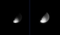
The latest Iapetus view... composite of two images again.
Phil

|
Posted by: Michael Capobianco Apr 11 2006, 04:05 AM
The ridge is certainly older than many of the small craters superposed on it, and it would probably support Matson's theory if it were the oldest feature there. If the ridge is younger than the northern basin and formed at a time when Iapetus's crust was very plastic, there should be evidence of that in the basin as well.
Michael
Posted by: Big_Gazza Apr 11 2006, 09:52 AM
Seems odd that most of the Iapetus images seem to be at a near-constant exposure time. I would have expected images to be taken at differing exposure times to suit the differing surface reflectivities, short exposure for the high(er)-albedo southern region, and long exposures to bring out details in Cassini Regio.
Cheers,
Gary
Posted by: ugordan Apr 11 2006, 09:57 AM
There probably have been different exposure times used, but you can't deduce that from the raw images as they are automatically histogram-stretched before being posted on the net as JPEGs. As a result, most of the frames tend to have the same brightness.
The stretching makes it impossible to figure out the real color of the objects, one can only map color differences.
Posted by: TritonAntares Apr 11 2006, 01:54 PM
Hi,
next Iapetus-series is released, altogether 9 raw-images.
Here a triplett - original, enhenced by gradation, and 2 negatives for dark/bright hemisphere;
the overexposed southern disk rim is really difficult to manage...

|
Date: 2006/04/09
Distance: 691.667 km
Filters: CL1 and CL2
Bye.
Posted by: volcanopele Apr 11 2006, 07:24 PM
There are downlink contraints on how much you can do that, but for each sequence, at least two clear filter images were taken at two different exposure times, one at 380 ms and another at 820 ms (at least for these most recent images).
Posted by: Phil Stooke Apr 12 2006, 01:13 PM
the latest batch of Iapetus images... I stacked four frames - little effect at the south pole, but it's important for reducing the JPEG artifacts in the dark area.
Phil
|
Posted by: tasp Apr 12 2006, 02:43 PM
Michael
With the 'lumpy' profile of Iapetus, I feel it is plausible Iapetus crust was either never very plastic, or achieved rigidity at a very early stage of its' formation. It is why we so many large, ancient and (relatively) well preserved basins.
Iapetus had an enormous volume of space to sweep for its constituent primordial materials, and it pokes around Saturn at (IIRC) ~5000 km/hr.
I think it is pretty safe to say accretion of Iapetus was 'leisurely' and that impact heating had a uniquely long time to radiate away.
Also, decay of AL26 heating of the proto Iapetus would have been significantly reduced compared to other bodies, the heating caused by this would have been radiated from numerous 'moon-itesimals' rather than the body of Iapetus itself.
Posted by: TritonAntares Apr 12 2006, 07:18 PM
So,
next Iapetus-image series released,
19 altogether, including 4 overexoposures.
Two Takeouts:
|
Date: 2006/04/10
Distance: 657.203 km
Filters: CL1 and CL2

|
Date: 2006/04/10
Distance: 622.761 km
Filters: CL1 and IR3
Closest approach is near...
Bye.
Posted by: scalbers Apr 12 2006, 07:57 PM
Greetings all,
I thought I'd mention my latest Iapetus map update. This has a rather preliminary inclusion of an image from the current April flyby. A previous update (from a week or so ago) has improved preprocessing of the Saturn-shine images yielding higher resolution and less cosmic ray hit noise.
Interesting to watch the current flyby and to select the best image portions for inclusion in the map.
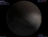
The most recent map update is always at http://laps.noaa.gov/albers/sos/sos.html#IAPETUS
Posted by: Phil Stooke Apr 12 2006, 08:27 PM
Here's a polar azimuthal equidistant projection of Steve's new map, south side only.
Phil
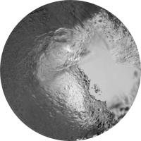
|
Posted by: TritonAntares Apr 12 2006, 10:33 PM
Hi,
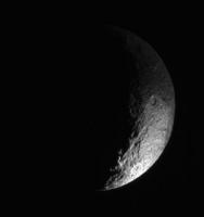
Southpol view of the terminator on April 11th:
|
Bye.
Posted by: dilo Apr 13 2006, 05:10 AM
Combination of a long unfiltered exposure (negative image) with green-filtered one:
|
Posted by: TritonAntares Apr 13 2006, 10:28 AM
Hi,
Some interesting structures are visible in your last picture, Marco:
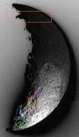
|
orange box: equatorial ridge; its height is really enormous as the extend of the sunlighted part into the dark hemisphere supposes
blue quadrangle: large mountain
green circle: large impact crater
red lines: ridge on left side; maybe a rift/graben structure altogether
violet circles: mid sized craters inside this graben
yellow circle: eventually disturbed crater? Depth inside the graben?
Maybe april 11th images will show some more details...
The upcoming days will show a probable better illumination angle.
Bye.
Posted by: TritonAntares Apr 13 2006, 12:59 PM
Hi,
the closest Iapetus-series seems to be released, altogether 6 raw-images until now.
Here three takeouts:
|
Date: 2006/04/11
Distance: 606.161 km
Filters: CL1 and GRN
|
|
Date: 2006/04/11
Distance: 605.979 km
Filters: CL1 and CL2
GREAT SURPRISE...????
Eruptions also happening on Iapetus?
Or are these rays effects of scattered sunlight?
Bye.
Posted by: Decepticon Apr 13 2006, 01:15 PM
Looks like JPL is having a hard time getting the saturnshine images to work, Unless they are attempting something else with these images?
Posted by: TritonAntares Apr 13 2006, 01:39 PM
unless they are attempting something else with these images?
I believe these images were taken this way for showing some kind of eruptions, fountains, etc., if they exist.
Therefore the rest of Iapetus is cut off.
Saturnshine images were nonsense to this date.
As said before Iapetus is showing his anti-saturn hemisphere.
Overexposured images were taken before to show features at the terminator, these two pics definitely don't.
Question to be answered:
True eruptions or effects of scattered sunlight?
And if eruptions do exist, where are they placed?
I may be wrong with the orientation of the image,
but it looks like they could be from the equatorial ridge -> western CR -> white peaks...
EDIT:
I tried to construct the local source of the rays:
(assumed CASSINI was oriented in the same direction, while taking both pics!)
|
Doesn't really look like western CR -> white peaks, at most the equatorial ridge...
Maybe we are just observing scattered saturnlight of the saturnshine-side of Iapetus...
Bye.
Posted by: Rob Pinnegar Apr 13 2006, 03:06 PM
It's hard to say for sure, but my first guess is that the overexposed images might be an attempt to pick up some of the migration of water ice vapour from Cassini Regio towards Roncevaux Terra. Cassini's current position relative to Iapetus presents a good opportunity for that, since Iapetus is a crescent, and most of the part of Iapetus that we _can_ see is dark Cassini Regio material.
This ought to allow for really long exposure times before image saturation -- and long exposure times would be necessary to pick up something so faint. I've no idea how strong an effect this proposed migration is supposed to be, but, intuitively, it probably wouldn't be anywhere near as easy to spot as Enceladus' plumes.
It's difficult to tell whether that "wispiness" in the overexposed images is just a result of the overexposure or something real. It might be worthwhile to make a movie of those images in chronological order. That might give a clue as to whether we're seeing a physical process. It wouldn't be proof, but it would be half decent circumstantial evidence.
[Edit: Over the next few days, we might get another clue. One would expect that, if the water ice vapour were visible to Cassini's cameras, it might appear to be a bit denser on the Saturn-facing part of the sunlit side, because it is "afternoon" on that part of Iapetus at the moment, while the part we're seeing right now is experiencing "morning". Thus it should be a few Kelvins warmer on the Saturn-facing side and we *might* see a greater density of evaporated "wispiness" there. As Cassini moves behind Iapetus, it will be well positioned to see something like this happening. If it's happening. This is total conjecture on my part, of course.]
In other news, that south polar region seems to be turning up a lot of neat stuff. Of course we have to remember that any vertical relief close to the terminator is going to be really, really obvious, but it's still an interesting patchwork-quilt. I hope we will get a better look at it during the September 2007 close flyby.
Posted by: Michael Capobianco Apr 13 2006, 04:10 PM
It's funny. If I use my imagination, what that area reminds me of a little is Miranda. There's a sort of chevron, and a zig-zag mountain. But if this pass has convinced me of anything, it's that there's no substitute for improved resolution.
Michael
Posted by: JRehling Apr 13 2006, 07:35 PM
Or are these rays effects of scattered sunlight?
Those rays are probably stars. The long exposures let the star tracks run for a distance across the image. Note that the lower end of all of those tracks have the same squiggles in them.
Posted by: hendric Apr 13 2006, 09:04 PM
Well, of course the diagonal streaks are stars, but what is the wispyness extending upwards? It doesn't really LOOK like a camera artifact, look at how it kinda bends and isn't rounded.
Posted by: Rob Pinnegar Apr 13 2006, 10:10 PM
I don't see the "bending" you refer to, but I don't think camera artifacts would be incapable of having a curved appearance.
My guess, for what it's worth, is that the "wispiness" we are seeing is due to overexposure (I'm not referring to the star trails here) since migration of water ice should be more of a global phenomenon rather than a regional one. The overexposed images might still be an attempt to spot migration -- but, if that's true, it doesn't mean the attempt was a success.
Also, it's tough to imagine how Iapetus could have plumes. Even if an energy source could be found, the moon's overall ruggedness and the dark albedo of Cassini Regio seem incompatible with any long term geological activity, or ongoing "snowfall".
Posted by: angel1801 Apr 14 2006, 08:50 AM
This ought to allow for really long exposure times before image saturation -- and long exposure times would be necessary to pick up something so faint. I've no idea how strong an effect this proposed migration is supposed to be, but, intuitively, it probably wouldn't be anywhere near as easy to spot as Enceladus' plumes.
It's difficult to tell whether that "wispiness" in the overexposed images is just a result of the overexposure or something real. It might be worthwhile to make a movie of those images in chronological order. That might give a clue as to whether we're seeing a physical process. It wouldn't be proof, but it would be half decent circumstantial evidence.
[Edit: Over the next few days, we might get another clue. One would expect that, if the water ice vapour were visible to Cassini's cameras, it might appear to be a bit denser on the Saturn-facing part of the sunlit side, because it is "afternoon" on that part of Iapetus at the moment, while the part we're seeing right now is experiencing "morning". Thus it should be a few Kelvins warmer on the Saturn-facing side and we *might* see a greater density of evaporated "wispiness" there. As Cassini moves behind Iapetus, it will be well positioned to see something like this happening. If it's happening. This is total conjecture on my part, of course.]
In other news, that south polar region seems to be turning up a lot of neat stuff. Of course we have to remember that any vertical relief close to the terminator is going to be really, really obvious, but it's still an interesting patchwork-quilt. I hope we will get a better look at it during the September 2007 close flyby.
I have checked the "Solar System" simulator for Iapetus around September 12, 2007 and I have some good news. Iapetus's south pole will be visible. However it will be at the very bottom of any global (whole disk) images and therfore not be optimally imaged. I hope that there might be a slight change to the flyby sequence to improve the imaging of the south pole more optimal.
Posted by: ugordan Apr 14 2006, 09:32 AM
Geez. http://www.unmannedspaceflight.com/index.php?s=&showtopic=2549&view=findpost&p=49096, anyone?
Posted by: angel1801 Apr 14 2006, 12:41 PM
I'm sorry for the "Rule 3.5" breaches. In most other forums I've contributed to, this style was encouraged and followed to the letter. Now I know here it is not on.
However, I can tell you of 11 new images of Iapetus. These are about one day after C/A. And the comments on the September 2007 flyby still stand.
Posted by: TritonAntares Apr 14 2006, 01:27 PM
So,
next 9 Iapetus-images were released.
Three Takeouts:

|
Date: 2006/04/12
Distance: 610.581 km
Filters: CL1 and CL2

|
Date: 2006/04/12
Distance: 611.252 km
Filters: CL1 and CL2
Interesting structure at the upper end of the terminator,
maybe the right rim of a larger crater...

|
Date: 2006/04/12
Distance: 611.400 km
Filters: CL1 and CL2
The rays are still visible, but fainter as in the image yesterday.
The exposuretime was certainly shorter as the lenght of the startrails imply.
Compare the angle of the left ray with the others today and yesterday;
was there any change?
Bye.
Posted by: Bob Shaw Apr 14 2006, 03:07 PM
Regarding the 'rays', the large dim circular feature (sort of anti-vignetting) makes me pretty sure it's internal reflection/refraction.
Bob Shaw
Posted by: TritonAntares Apr 14 2006, 05:53 PM
Hi,
I tried to identify some topografic southpole structures in the april 12th images:

|
The map is a part of Phils' latest southpolar azimuthal equidistant projection.
Unfortunately the marked southpole stays in shadow.
EDIT:
Apparently there will be some 'cut images' of Iapetus:

|
Maybe first saturnshine at the upper disk rim?
We'll see...
Bye.
Posted by: scalbers Apr 14 2006, 11:31 PM
Greetings,
Nice to see all the updates and image analysis. From what I can gather on Mark Showalter's web site, the south pole actually has a solar elevation of about 3 degrees right now so it shouldn't really be in too deep of a shadow. I'm beginning to think my map will (at some point) need adjustment by a couple of degrees with some of the features marked above by Triton Antares moved closer to the pole to get them navigated right. We should also enjoy the current flyby in the sense that the 2007 flyby will have the south pole lying in a deeper shadow.
I'm currently working with some of the more recent images so I hope to post a new map when I get a clean result that is better than what was previously posted.
Posted by: tasp Apr 15 2006, 04:04 AM
If I could field a question:
Does the ~14 degree tilt of the Iapetan orbit around Saturn make the plane of the Iapetan orbit more parallel to the ecliptic or less?
Does this parameter change over time? Would that be precession?
The orientation of the plane of Iapetus' path about Saturn relative to the sun is what I'm getting at.
Posted by: BruceMoomaw Apr 15 2006, 06:41 AM
Oh, yes, it precesses. (The similar precession of Triton's even greater 23-degree tilt compared to Neptune's equator leads to fantastically complex seasonal cycles for Triton. Its most extreme seasons come along about every 700 years, and by pure coincidence the peak of its latest 175-year summer will come next year -- which seems to be having interesting effects on its surface optical properties, judging from the fuzzy Earth-based data we've gotten on it since Voyager 2. But I don't know what the seasonal cycles are for Iapetus, or for that matter for our own Moon.)
Posted by: TritonAntares Apr 15 2006, 09:15 AM
Hi!
Steve, you should probably be careful with the position of the southpole I marked in my image above:

|
with some of the features marked above by Triton Antares moved closer to the pole to get them navigated right.
So there could be a mistake in the real southpole position.
more parallel to the ecliptic or less?
Does this parameter change over time? Would that be precession?
The orientation of the plane of Iapetus' path about Saturn relative to the sun is what I'm getting at.
Who can help?
---------------------------------------------------------------------------------------------------------------------------------------------------------------------------
leads to fantastically complex seasonal cycles for Triton.
Its most extreme seasons come along about every 700 years,
and by pure coincidence the peak of its latest 175-year summer will come next year -
which seems to be having interesting effects on its surface optical properties,
judging from the fuzzy Earth-based data we've gotten on it since Voyager 2.
but btw are there anywhere animations or graphics showing this more detailed?
Bye.
Posted by: BruceMoomaw Apr 15 2006, 11:43 AM
I've long been aware of these strange Triton 'seasons',
but btw are there anywhere animations or graphics showing this more detailed?
Bye.
I believe I've seen a graph SOMEWHERE on the Web, although finding it may be a pain.
Posted by: tasp Apr 15 2006, 02:27 PM
The earth's moon's orbital inclination (ref'd to earth) seems to be constant in it's orientation to the plane of the ecliptic (hence allowing the possible existence of permanently shadowed craters around the poles).
I am still fuzzy if the orientation of the Iapetan orbit around Saturn maintains a constant orientation to the ecliptic. Eath's axis manages to precess every 23,000 years or so, yet the moon doesn't stray more than (IIRC) 5 degrees or so from the ecliptic. Has the equivalents for all of this been worked out for the Saturn system? Does Saturn currently have a prominent Polaris type polestar now?
If it doesn't, does the northern and southern boundaries (diffuse though they may be) of Cassini Regio correspond roughly to the Iapetan equivalents of the earth's Tropics of Capricorn and Cancer?
If Cassini is 'pinning' down Iapetus' location to a few kilometers, perhaps subtle shifts in this would be measurable.
Posted by: David Apr 15 2006, 02:40 PM
Yes it does. It is, amazingly enough, Polaris. Saturn's north celestial pole is actually about 5° away from Polaris, not nearly as good a fit as ours, but not much worse than what our fit has been in historical times. Polaris is much closer to our north celestial pole now than it was when it first received its name.
Posted by: angel1801 Apr 15 2006, 06:56 PM
I am here to tell you that lots of new Iapetus images are in, ranging from about 700,000 km to 820,000 km.
It is apparent from some these new images, they have finally achived some "saturnshine" images of Iapetus's south pole area.
Posted by: TritonAntares Apr 15 2006, 08:07 PM
Hi,
a large downlink of 39 images is now online.
Here some takeouts:

|
Date: 2006/04/12
Distance: 635.690 km
Filters: CL1 and GRN

|
Date: 2006/04/13
Distance: 693.920 km
Filters: CL1 and CL2

|
Date: 2006/04/13
Distance: 695.107 km
Filters: CL1 and CL2
The rays are definetly caused by some kind of refraction!

|
Date: 2006/04/13
Distance: 711.567 km
Filters: CL1 and GRN

|
Date: 2006/04/14
Distance: 816.681 km
Filters: CL1 and CL2

|
Date: 2006/04/14
Distance: 817.109 km
Filters: CL1 and CL2
The last two pics show a large mountain at the cresents' lower end.
I tried to locate it with Solar System Simulator, but look for yourself:

|

It is possible the same mountain we saw at the right limb at the begin of this far-encounter on april 1st.
Bye.
Posted by: Decepticon Apr 15 2006, 11:09 PM
Huh!? Where?
Posted by: BruceMoomaw Apr 16 2006, 03:34 AM
but btw are there anywhere animations or graphics showing this more detailed?
Bye.
It took me awhile, but here's a graph of the latitude of Triton's subsolar point over historical time (albeit most of the text is in French):
http://bugle.imcce.fr/fr/observateur/support/Triton/
Or, rather, SEVERAL graphs -- there seems to be some disagreement on the calculation of this.
Posted by: angel1801 Apr 16 2006, 06:05 AM
Looking really close to some of the over exposed shots (and making them brighter), I saw features like craters and topographic features on the south pole. ie a group of three craters close together.
I could be wrong though.
Posted by: TritonAntares Apr 16 2006, 10:54 AM
Or, rather, SEVERAL graphs -- there seems to be some disagreement on the calculation of this.
Many thanks for this informative link.
It'll probably help to improve my dormant basic french knowledge...
First impression:
Triton's seasons don't look that simply predictable as Earth's....
Bye.
Posted by: TritonAntares Apr 18 2006, 01:14 AM
Hello,
next 8 Iapetus-cresents are online now.
Two Takeouts:

|
Date: 2006/04/15
Distance: 939.055 km
Filters: CL1 and GRN

|
Date: 2006/04/15
Distance: 939.528 km
Filters: CL1 and CL2
Nearly half of Iapetus should be in saturnshine.

|
But there is nothing visible yet.
Enhencement of the overexposure only showed me some artefacts...
Bye.
Posted by: ugordan Apr 18 2006, 07:37 AM
But there is nothing visible yet.
Enhencement of the overexposure only showed me some artefacts...
Don't expect too much at this point. Saturn is still at a http://space.jpl.nasa.gov/cgi-bin/wspace?tbody=699&vbody=608&month=4&day=18&year=2006&hour=00&minute=00&fovmul=1&rfov=5&bfov=30&showsc=1 seen from Iapetus and its distance, combined with JPEG artifacting will make any saturnshine features (if present) destroyed in the raw images.
Posted by: TritonAntares Apr 18 2006, 01:35 PM
So,
next 7 Iapetus-cresents from april 17th (16th was left out) are online.
Two takeouts:

|
Date: 2006/04/17
Distance: 1.098.558 km
Filters: CL1 and GRN

|
Date: 2006/04/17
Distance: 1.098.866 km
Filters: CL1 and CL2
Visible structures:

|

|
Bye.
Posted by: scalbers Apr 18 2006, 06:15 PM
Thought I'd mention my next Iapetus map iteration. This again has images up through 4/11/2006 and hopefully a little better consistency and south pole location. This is very much a work in progress as one might imagine so I hope to improve the coverage including perhaps additional images and to reduce navigation errors further as we go.
http://laps.noaa.gov/albers/sos/sos.html#IAPETUS
Posted by: angel1801 Apr 19 2006, 02:09 PM
Some new Iapetus images are just in.
Distances are from about 1,100,000 km to about 1,300,000 km away.
This set includes four over exposed shots.
Posted by: scalbers Apr 19 2006, 04:44 PM
Greetings,
Here's the next mapping update. Using pretty much the same images up through April 11, I adjusted the navigation a bit more and added further coverage. This includes mapping of the mysterious high terrain that is catching the light beyond the terminator. It just so happens to fill in a good bit of the gaps representing "Iapetea incognita".
http://laps.noaa.gov/albers/sos/sos.html#IAPETUS
Posted by: TritonAntares Apr 19 2006, 07:18 PM
Hi,
the obvious final Iapetus images series for this far-encounter has been transmitted,
altogether 12 pics:
Three Takeouts:

|
Date: 2006/04/17
Distance: 1.198.035 km
Filters: CL1 and GRN

|
Date: 2006/04/18
Distance: 1.329.380 km
Filters: CL1 and CL2

|

|
Date: 2006/04/18
Distance: 1.329.770 km
Filters: CL1 and CL2
There seems to be a waft of saturnshine texture...
Maybe the higher (12-bit) resolution will show more.
Bye.
Posted by: scalbers Apr 20 2006, 04:38 PM
Looking ahead just a bit I see via Celestia that the Sep 2007 flyby should fill in the remaining gaps almost perfectly. This takes into account both Cassini and Voyager images to date.
Posted by: TritonAntares Apr 20 2006, 05:03 PM
Hi,
here a look on the improvement of our topografic knowledge of Iapetus' southern hemisphere due to this far-encounter:

|
There is still a missing quarter left, some parts surely being filled during sep 2007 fly-by.
But for the rest there should be (at minimum) an additonal encounter passing the region of the large southern bassin there
during the extended mission.
EDIT:
This takes into account both Cassini and Voyager images to date.
Is this fly-by not too close (~1000 km) to show the whole iapetean globe (especially the pol regions)?
Look at this planned image coverage:

|
While diverging from Iapetus CASSINI will definetly map the trailing hemisphere from greater distance:

|
Or am I wrong?
Bye.
Posted by: scalbers Apr 20 2006, 06:43 PM
I enjoy seeing your illustrations Triton-Antares. I'll try to do a screen capture later on to illustrate my point. I think we are saying consistent things in that the view from roughly 100000-300000km out after the closest approach could allow regional coverage of almost the entire area of gaps in the trailing hemisphere. This is reflected in your bottommost image. They could also perhaps take some WAC images closer in to get more of a large-scale view? Are there any planned images beyond the NAC real closeups plotted above?
EDIT:
This http://laps.noaa.gov/albers/sos/saturn/iapetus/iapetus_sep2007.jpg might be nice to capture from Cassini. Is Celestia handling the Cassini oriented perspective reasonably?
On another note I made a new slight tweak to the map today that shows one of the craters better that you had marked in your April 17 crescent comparisons (post 141). I'm sort of glad that I pretty much have until Sep 2007 to catch up on this type of cleanup
Posted by: Rob Pinnegar Apr 20 2006, 09:23 PM
Just checking the 2007-10-09 flyby: As it happens, the closest approach to Iapetus occurs near noon UTC, so Cassini starts the day 10^5 kilometres from Iapetus, and finishes the day 10^5 kilometres from Iapetus. That's over 24 hours of approach time that will be better than what we've seen before. Lots of time for imaging.
The focus of this flyby is of course the "far side" of Iapetus, that faces away from Saturn -- but, as Cassini approaches Iapetus, the Saturn-facing "near side" of the moon will be pretty well lit by Saturnshine. So there ought to be some improvement in imaging this part of the moon, especially the trailing, Saturn-facing quarter-sphere.
Posted by: tasp Apr 21 2006, 01:01 AM
EDIT:
This http://laps.noaa.gov/albers/sos/saturn/iapetus/iapetus_sep2007.jpg might be nice to capture from Cassini. Is Celestia handling the Cassini oriented perspective reasonably?
Comparing your nice globe shot with the image map from TritonAntares, it looks like we get some very good shots of the infamous 'equatorial white dots' known since the Vogager II flyby so long ago.
Are they just random peaks poking through the 'black stuff'?
Are they a continuation (although intermittent) of the equatorial ridge structure?
Do they continue the steady progression of height noted from the east end of the ridge?
It looks like the resolution on the surface of Iapetus for the NAC will be very impressive, will the black coating be continuous at that resolution?
Will possible surface 'chunks' be apparent 'beneath' the coating?
The 'dots' seem to progress accross a smaller basin (hard to say 100%), interesting to have a glimpse at possible 'root' structure of the feature.
Are the 'dots' discontinuous due to slides of material, and/or cratering damage?
Are the sides of the ridge structure (and/or the 'dots') plausibly at the angle of repose expected for icy materials simply 'dumped' in a pile on the surface of Iapetus?
If the 'dots' are a continuation of the equatorial ridge structure, that elements of it are white, and some parts blsack, can we conclude the dark staining material is unridge related?
Will we see parallel faulting due to the (presumed) great weight of the structure bearing on the surface materials of Iapetus?
Will the smallest (and presumably freshest) craters have no or intermediate levels of the 'black stuff'?
Would it be useful (and/or possible) for a radar scan at closest approach to evaluate the surface materials for a possible future rover mission?
(btw, are we ever close enough to a moon other than Titan, where the radar instrument could do a useful scan in the unilluminated portion of the target?)
I assume from the 'leisurely' loiter time at Iapetus that we will get some nice infrared scans and some polarimetry, etc. of the Iapetan surface.
Hard part is the wait . . . .
Posted by: ugordan Apr 21 2006, 07:14 AM
(btw, are we ever close enough to a moon other than Titan, where the radar instrument could do a useful scan in the unilluminated portion of the target?)
Radar was used on many occasions before, though not in SAR mode which I believe you're implying. Synthetic aperture turns out to be useful up to a distance of around 1500 km, but since we're already going to fly above the sunlit side, if we wanted to "illuminate" the dark side with the radar, the illumination angle would probably be very oblique and from a great distance -- probably not all that useful.
What can also be done with the radar is probing the first few centimeters of the surface material to reveal the properties of the material. IIRC this was also used at Phoebe, where they tried to differentiate between water ice and other stuff like CO2 ice.
Posted by: TritonAntares Apr 21 2006, 02:02 PM
Hi,
I'm wondering how close CASSINI will pass Iapetus on sep 10th, 2007.
I guess I've read something about 1000-1500 km, but these two simulation programs give different distances...
Solar System Simulator (2065 km):

|
Animation made with Celestia (~5500 km):
Iapetus_sep_2007_xxx.avi.html ( 431.5K )
: 471Just remove *.html and run the avi-file.
I prefer running on a DIVX-player.
after the closest approach could allow regional coverage of almost the entire area of gaps in the trailing hemisphere.
This is reflected in your bottommost image.
They could also perhaps take some WAC images closer in to get more of a large-scale view?
Are there any planned images beyond the NAC real closeups plotted above?
The mentioned planned image coverage is unfortunately the only ISS-preview I found.
I'm very keen on some additional infos.
-------------------------------------------------------------------------------------------------------------------------------------------------------
interesting to have a glimpse at possible 'root' structure of the feature.

|
My impression is that its central peak doesn't coincide with the 'white peak' NW of it and it is also lower.
Thus the crater must be older than the mountain.
This 'white peak' seems to cast an enormous shadow (blue quadrangle) to its western side.
Is the equatorial ridge interrupted there?
Is there any ridge at all or only these 'white peaks'?
One thought:
If the ridge is driven by some interior force, it looks like a chain of 'volcanos' there.
Could there once be a process going on, similar to hot spot chains like on Earth (Mars & Venus),
where material rose to the iapetean equator while its crust was moving overhead?
For this the eastern part of the ridge is older and in one part as material ascended and/or the crust moved continuously.
The western 'white peaks' are higher newer cones, because material rise and/or crust moving stopped partly...
But the question why the peaks are white is still unanswered...
Sep 10th, 2007 will hopefully give answers to all....
Btw,
IAU should finally have given names to new found iapetean structures till then.
Roughly 1,5 years. It's time enough....
Or are they overwhelmed with deciding whether Pluto or UB313 are planets or not...?
Bye.
Posted by: angel1801 Apr 21 2006, 02:15 PM
I just wonder. To keep the solar system to nine planets, which we all learnt at school and everybody has grown to love, Pluto should remain a planet NO MATTER WHAT!
Posted by: scalbers Apr 21 2006, 04:34 PM
If the ridge is driven by some interior force, it looks like a chain of 'volcanos' there.
Could there once be a process going on, similar to hot spot chains like on Earth (Mars & Venus),
where material rose to the iapetean equator while its crust was moving overhead?
For this the eastern part of the ridge is older and in one part as material ascended and/or the crust moved continuously.
The western 'white peaks' are higher newer cones, because material rise and/or crust moving stopped partly...
But the question why the peaks are white is still unanswered...
And could the belly band in general even have some similarities to mid-oceanic ridge systems on Earth?
Posted by: ljk4-1 Apr 21 2006, 04:46 PM
Future generations, flush with all the new data on worlds both bigger and far more
numerous than Pluto, will probably not feel the same way.
It's time to call the TNO/KBO Belt objects something, but not actual "main" planets.
Posted by: Michael Capobianco Apr 21 2006, 05:01 PM
I'm wondering how close CASSINI will pass Iapetus on sep 10th, 2007.
I guess I've read something about 1000-1500 km, but these two simulation programs give different distances...
]
The Planetary Society gives the closest approach distance as 1,229 km.
My guess is that the peaks are white because the dark stuff thins out at the equatorial edges of CR. It's interesting that the bellyband was in so little evidence during this last pass. Except for one overexposed terminator jag, I couldn't see much evidence for it at all, and there was no discernible bump on the limb.
Michael
Posted by: TritonAntares Apr 22 2006, 10:05 AM
Hello,
one of the many questions raised by the april far-encounter
is the exact position of this mountain at the border of eastern CR.
To remember, these illustrations:
Date: 2006/04/01

|
Date: 2006/04/15
Is that really the same mountain?
I tried to find some possible locations on the map - red circles:

|
Who is able to identify the real location, probably marking the mountains in the images
and using some map projections software?
Thx. & Bye.
Posted by: scalbers Apr 22 2006, 02:35 PM
Hello Triton-Antares,
An initial quick comment would be that what I see as a crater circled in your middle image is the same one at the very bottom (left) of the map section you show in the lower image. This is actually the same crater I cleaned up a bit in my latest map version from April 20. This is also circled by you in post 141.
This may be different from the mountain you show in the top image. Could this be the Snowman crater central peak? Perhaps some reprojecting experiments can help address this as you suggest.
Addendum:
Oops, correct "bottom (left)" to read "bottom (right)". I'll try to edit this later when I'm working on a real computer.
Posted by: Michael Capobianco Apr 22 2006, 04:20 PM
Here are Saturn Viewer results for
April 1:

|
April 15:

|
Perhaps there's a way to get lat and lon information displayed in Saturn Viewer, but I don't see it.
Michael
Posted by: tasp Apr 22 2006, 08:01 PM
TritonAntares, thanx for posting the equatorial white peaks picture.
If I am orienting this all in my head correctly, the peaks are experiencing (more or less), high noon as Iapetus passes directly sunward of Saturn.
Additionally, the north south extent of the 'stain' is dramatically 'necking down' in their range of longitude.
My thinking again turns to insolation as a causitive factor for CR. Steep sides of isolated peaks along the equator would be tough surfaces to build up significant (relative to the rest of Iapetus) heating from sunlight impingement. A gaseous material temporarily in the vicinity of Iapetus requiring heat to polymerize and fall to and stain the surface again being plausible. The gaseous materials either dissipate to the void in less than 80 days, or react to the warm surface and are consumed.
The gas would be replenished during Iapetan traverses of the Saturn magnetotail when it is transporting larger amounts of gas from the Titan atmosphere freed by big impacts, or perhaps a slow steady drizzle (spritz?) of simply leaked atmosphere.
The gas is always 'applied' to Iapetus in the same place in its' orbit about Saturn, and Iapetus always turns the same face sunward after every application for the insolation to 'paint' the 'sludgified' gas onto the surface.
South facing crater walls in the northern hemisphere of Iapetus, and the north facing crater walls in the south, are able to maintain their needed angle to the incoming sunlight to maintain their temps for this reaction to occur furhter north and south than average.
Posted by: TritonAntares Apr 23 2006, 11:08 PM
are able to maintain their needed angle to the incoming sunlight to maintain their temps for this reaction
to occur furhter north and south than average.

|
Remarkable is the height of its northern dark rim.
Astonishingly there has no such crater been found on the southern hemisphere so far.
At least I've seen none for myself....
Bye.
Posted by: tasp Apr 24 2006, 01:12 AM
My best response to your excellent point will be that we need to wait for comparable higher resolution photos of the mid southern to far southern latitudes if we don't already have them.
Had not considered this aspect of the puzzle.
I will assert symmetrical poleward craterwall darkening on both the northern and southern hemispheres of Iapetus are required for the thermosensitive gaseous discolorant idea.
Make or break prediction if you will.
I'll go check swampcats processed images over at SDC . . . .

Posted by: tasp Apr 24 2006, 01:38 AM
I haven't really found (after a brief search) comparable pictures of the poleward crater wall darkening effect for the southern hemisphere. The distant whole disc shots taken from the ~equatorial plane show similar polar area motling or stipling, but I do not find that conclusive.
As Spock says, fascinating . . . .
Posted by: volcanopele Apr 24 2006, 07:37 PM
IAU should finally have given names to new found iapetean structures till then.
Roughly 1,5 years. It's time enough....
Or are they overwhelmed with deciding whether Pluto or UB313 are planets or not...?
The IAU sub-committee that choses names for features on places like Iapetus is completely different from the one that will work out the whole 2003 UB313 issue. So, there isn't a conflict in man-power on these two different problems.
I am not sure where we are in terms of Iapetus names. I know features have been selected for naming, I don't know where are now though. The group that is working that out, also is working on names for Enceladus, Dione, Rhea, Tethys, and Mimas, so perhaps there is a man-power issue there.
Posted by: TritonAntares Apr 25 2006, 08:47 AM
is completely different from the one that will work out the whole 2003 UB313 issue.
So, there isn't a conflict in man-power on these two different problems.
Nice to read.
Hopefully there will be some namings mainly for the bassins and larger craters in near future.
The commitee will perhaps wait chosing names for smaller until now bad resolved structures like the 'white mountains' until the sep. 2007 fly-by.
Bye.
Posted by: angel1801 Apr 25 2006, 09:33 AM
I am glad that the IAU is finally getting around to name all those new features on Enceladus, Dione, Rhea, Iapetus, Tethys and Mimas. Is there a website available so we can see the current status on this process?
Posted by: TritonAntares Apr 26 2006, 12:02 AM
Hello,
I tried again to locate the mountain visible on the images of april 15th more accurately:

|
Blue box: equatorial ridge east of great bassin in eastern CR
Red circle: mountain
Additional help were the pics from http://cassinicam.com/isslookup/html/72385.html.
Unfortunately I found no simulation software showing Iapetus textures as well as a suitable coordinate frame.
Concerning the mountain at the right disk rim on april 1st:
Could this be the Snowman crater central peak?
Perhaps some reprojecting experiments can help address this as you suggest.

I don't believe it's the the central peak of the Snowman.
That should be more to the northeast.
Whether it's the mountain in the red circle above, the ridge in the blue box or even another peak remains uncertain...
Bye.
Posted by: scalbers Apr 26 2006, 06:52 PM
Triton-Antares,
If I can partly address this, I believe the red circle in the upper right crescent image coincides with the (this time unmarked) crater at the very bottom (left) of the section shown from my map.
Posted by: TritonAntares Apr 26 2006, 08:44 PM
Hi Steve,
I think you mean the green encircled crater on your map (probable mountain in rectangle):

|
This crater could also be the green encircled structure in the upper raw image.
Because of poor resolution and the perspective at the rim this is actually difficult to decide.
A suitable coordinate frame layed over map and raw image could only answer this question finally.
Bye.
Posted by: scalbers Apr 26 2006, 11:02 PM
Triton-Antares,
I am gathering some additional evidence that supports the conclusion that the green feature in the map at bottom (of your post) is the same as the red in the raw image at top. I took the April 15 image and ran it through my software. Comparing the cylindrically projected image shows this fairly clearly. The http://laps.noaa.gov/albers/sos/saturn/iapetus/ortho30_gridded.jpg on the raw image is here. The navigation was just done roughly but should be close enough to establish my hypothesis. A test map with just this image projected on it helps to clinch the case at the URL below:
http://laps.noaa.gov/albers/sos/saturn/iapetus/iapetus_rgb_cyl_30.jpg
Posted by: TritonAntares Apr 29 2006, 09:24 PM
Hello,
I tried again to identify some topografic structures of the latest Iapetus far-encounter.
This time I compared the the april 15th cresent-image with two from january 2006 and the map:

|
Astonishing how perspective and shadow can change the appearance of one structure...
Most impressive is this crater in the center of the january 24th image:

Bye.
Posted by: scalbers May 3 2006, 09:36 PM
Yes, the terminator really brings out the shadows and topographic relief. Overall that's quite a nice and colorful comparison of features from different vantage points. In looking at the 1/22/2006 image I realized it could add coverage to my map (every square degree counts ) so I have now updated this:
http://laps.noaa.gov/albers/sos/sos.html#IAPETUS
Might also be interesting to continue the comparison using a south-pole centered version of the map. I may try to reproject it sometime. Using Celestia can work though that software introduces quite a few artifacts near the pole.
Posted by: Phil Stooke May 4 2006, 07:04 PM
I'll do a south polar view when I'm back in my office.
Phil
Posted by: TritonAntares May 5 2006, 11:40 AM
Hi,
let me mention, there will be another Iapetus campaign between june 17th and 27th.
Unfortunately minimum distance will only be around 1,3 mio. km, resolution about 8,1 pxl/km.
Here a short animation done with Celestia:
Iapetus_june_2006.avi.html ( 373K )
: 941
Just remove *.html and run the avi-file preferably on a DIVX-player.
Bye.
Posted by: angel1801 May 5 2006, 02:31 PM
let me mention, there will be another Iapetus campaign between june 17th and 27th.
Unfortunately minimum distance will only be around 1,3 mio. km, resolution about 8,1 pxl/km.
Here a short animation done with Celestia:
Iapetus_june_2006.avi.html ( 373K )
: 941Just remove *.html and run the avi-file preferably on a DIVX-player.
Bye.
I've used the Solar System Simulator and I see that the Saturn facing hemisphere will almost fully visible at C/A on June 23, 2006. The distance may not be as good as the April 2006 flyby, but the June 2006 flyby will give lots of "Saturn Shine" opportunties. This is something the April 2006 flyby lacked.
Also, I can see lots of multi-spectral shots happening. This will probably be used to try to discern the type and positioning of materials on the Saturn facing hemisphere.
Posted by: TritonAntares May 7 2006, 11:01 AM
This will probably be used to try to discern the type
and positioning of materials on the Saturn facing hemisphere.
Multi-spectral shots, interesting. Where actually did you get this info?
http://www.cassinicam.com/sp/ for example are only listed until http://www.cassinicam.com/sp/scienceplanS18.html (2006JAN27 - 2006MAR11).
Bye.
Posted by: angel1801 May 7 2006, 07:50 PM
http://www.cassinicam.com/sp/ for example are only listed until http://www.cassinicam.com/sp/scienceplanS18.html (2006JAN27 - 2006MAR11).
Bye.
It is just a guess. But I think it would be done. Afterall, it is a rare oppurtunity to do something like this on the Saturn facing hemisphere of Iapetus. And apart from the targeted encounter on September 10, 2007, Cassini will get no closer to Iapetus that it will be on June 23, 2006.
And the "Cassinicam" site needs updating. We are now in early May now.
Posted by: JRehling May 7 2006, 08:13 PM
And the "Cassinicam" site needs updating. We are now in early May now.
I don't know about filtered images taken in saturnshine. Remember, a narrowband filter removes the overwhelming majority of the incoming light you'd have with the clear filters. If it leaves you with 5% (I'm pulling that # out of thin air), then you'd have 20x the exposure length, which would probably mean 20x the blurring due to pointing stability. I think that would be unacceptable for most purposes, and won't end up happening.
If this were Enceladus we were talking about, with its much greater proximity to Saturn and much brighter saturnshine, then it may be different. But Iapetus gets very little saturnshine.
Posted by: scalbers May 12 2006, 11:26 PM
Greetings,
I went ahead and set up a south polar view of Iapetus in a perspective projection. This is based on my recent map updates and can be seen at the URL shown below. It might be interesting to compare this with some of the individual images.
http://laps.noaa.gov/albers/sos/saturn/iapetus/iapetus_rgb_cyl_www_P1.jpg
Posted by: Decepticon May 20 2006, 04:01 AM
scalbers At this distance, are these images useful for mapping?
Posted by: scalbers May 20 2006, 03:52 PM
Well Decepticon it could be useful, depending on where the imaging is done. I'll have to look at the animation again in the office, though I recall it seemed to mostly cover familiar territory. You might consider that on my map there are a variety of resolutions used depending on location. I know I had used images from 1.3millon km and farther though much of that territory has since been superseded by closer images. Clearly if you're in some of the blank areas any resolution would be helpful. So we might have check in more detail to more fully answer your question.
One fun thing I've been developing in my software is an option allowing me to overlay an image automatically only in those areas where the resolution (coupled with spacecraft zenith angle) represents an improvement. While other factors (such as phase angle, etc.) should also be considered it's interesting to see where a new image gets pulled in.
Posted by: TritonAntares May 22 2006, 03:13 PM
Hi some 'colorful' news from Iapetus,
http://saturn.jpl.nasa.gov/multimedia/images/image-details.cfm?imageID=2140 a nice pic-pair from the JPL-site:
http://photojournal.jpl.nasa.gov/jpeg/PIA08164.jpg
Monochrome image:
Date: 2006-04-08
Distance: 866.000 km
Resolution: 5 km/pxl
Color image:
Date: 2006-04-09
Distance: 692.000 km
Resolution: 4 km/pxl
Bye.
Posted by: BruceMoomaw May 23 2006, 01:28 AM
Lovely piece of work. (And don't forget that good color images of Iapetus are scientifically important, since the dark material extending onto the trailing side of Iapetus seems to be distinctly less reddish than that on the leading side, supporting the new theory that the shape of the dark and light regions has been modified by the effects of warming by sunlight.)
Posted by: scalbers May 23 2006, 05:06 PM
Very interesting to learn more about the pattern of colors on Iapetus. I wonder if this image is corrected to look like an RGB image would (i.e. "near-true" color) or should be categorized as false color since it is taken with the UV, G, and IR filters? Curious that CR maybe looks a bit yellower than in some of the other color releases.
Posted by: ugordan May 23 2006, 06:27 PM
I'd venture to say the image looks so funny, compared to previous "true" color and false color images is because they used the IR3 filter in place of the IR1 usually used for stretched, "true-like" color (IR1-GRN-UV3). I had similar results pop up using the PDS data from the New Years flyby.
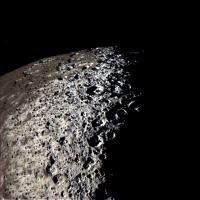
|
IR1-GRN-UV3, "natural-looking" color.
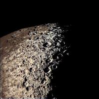
|
IR3-GRN-UV3, stretched/false color.
My guess on the true color of the Iapetus' dark stuff would be something like the first image above, but a less saturated shade of brown. The color differences across CR would be even less discernible in a RGB view, probably looking very monotone and dull.
Powered by Invision Power Board (http://www.invisionboard.com)
© Invision Power Services (http://www.invisionpower.com)