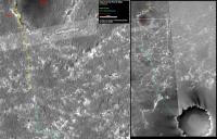
Opportunity Route Map |

  |
Opportunity Route Map |
 Mar 29 2006, 09:15 PM Mar 29 2006, 09:15 PM
Post
#1156
|
|
|
Senior Member  Group: Moderator Posts: 4279 Joined: 19-April 05 From: .br at .es Member No.: 253 |
True.
I'm not planning to update that part of the image so often. The idea is that whenever the left part should be "shifted up" to cover southern terrain (*), I will update the right part both the reference rectangle and the route. Anyway, I think it's quite easy to recognise the terrain features on both pics and extrapolate the current position from the left to the right image. (*) Given current Oppy's pace, I'll need to do that quite early. |
 |
 
|
|
Mar 29 2006, 09:47 PM
Post
#1157
|
|
|
Senior Member Group: Members Posts: 2998 Joined: 30-October 04 Member No.: 105 |
This is a good route map design that you've chosen.
I wish that the way were not as clear; during the "North Erebus Dunefield Detour" I rather enjoyed doing the daily hypothetical maps guessing where Oppy would head. Perhaps we can do that again when Oppy reaches Victoria. It would be great to have HiRISE coverage for the Victoria exploration planning (wishful thinking). --Bill -------------------- |
|
|
|
|
Mar 30 2006, 05:12 AM
Post
#1158
|
|
 Senior Member Group: Members Posts: 2228 Joined: 1-December 04 From: Marble Falls, Texas, USA Member No.: 116 |
QUOTE (Bill Harris @ Mar 29 2006, 03:47 PM)  ... It would be great to have HiRISE coverage for the Victoria exploration planning (wishful thinking). ... During one of the earlier MRO press briefings, someone said that they were planning to take imagery to help with the route planning for Opportunity's trek to Victoria. Obviously, such imagery would have to come from the pre-science phase of the mission during aerobraking. I am guessing that they will wait a while yet, in order to get into a lower altitude and more circular orbit, but apparently it is something that we might expect. My wishful thinking at this point is that they would release that imagery early enough that we could have fun using it en route. 
-------------------- ...Tom
I'm not a Space Fan, I'm a Space Exploration Enthusiast. |
|
|
|
|
Mar 30 2006, 08:32 AM
Post
#1159
|
|
|
Member Group: Members Posts: 295 Joined: 2-March 04 From: Central California Member No.: 45 |
QUOTE (MizarKey @ Mar 26 2006, 10:15 PM) I couldn't find any recent figures, but I'm fairly sure Oppy has taken back the distance lead. Anyone know which Sol it happened on? Ok, I found the data...it was during the drive of Sol 765 (Mar. 19th). As of 3/21/06 Oppy was 96 meters ahead. Not that they were planning to drive Spirit all that far anyway, but there is no way Spirit will ever take the lead back. Ok, I won't say 'no way' as Oppy could keel over any second, but I have faith Oppy will reach the apron of Victoria at a minimum. I've been reading "Roving Mars", what a great story. To read how many trials and tribulations these rovers went through before getting off of Earth, for them to be performing now is simply amazing. Everyone involved in the mission deserves a Mars bar! -------------------- Eric P / MizarKey
|
|
|
|
|
Mar 30 2006, 09:42 AM
Post
#1160
|
|
|
Senior Member Group: Moderator Posts: 4279 Joined: 19-April 05 From: .br at .es Member No.: 253 |
QUOTE (Bill Harris @ Mar 29 2006, 11:47 PM) I wish that the way were not as clear; during the "North Erebus Dunefield Detour" I rather enjoyed doing the daily hypothetical maps guessing where Oppy would head. Perhaps we can do that again when Oppy reaches Victoria. It would be great to have HiRISE coverage for the Victoria exploration planning (wishful thinking). I didn't include a "future path" on the route map because there are plenty of routes toward VC.  But, hey, it's not too late to start that. Actually the question is when/where will Oppy start to move East? |
|
|
|
|
Mar 30 2006, 03:45 PM
Post
#1161
|
|
|
Member Group: Members Posts: 530 Joined: 21-March 06 From: Canada Member No.: 721 |
QUOTE (Tesheiner @ Mar 30 2006, 03:42 AM) I didn't include a "future path" on the route map because there are plenty of routes toward VC. But, hey, it's not too late to start that. Actually the question is when/where will Oppy start to move East? Is there a need to move East? If they keep going in the current heading, perhaps with a slight veer eastward, there might be one difficult patch about 200 m south of your box border, but is there anything really insurmountable on that route? The north side of the crater seems to be sheer dropoffs, plus a steeper slope overall than the southern side. To me, the nearest safe entry point looks to be about 7:00 on the Victoria clock. I would guess a relatively straight line approach between there and the current position. OK, so I guess I've just made my route guess. We'll see how it holds up. As for arrival date, Tesheiner took my birthday, so I don't want to play that game now.   Brian |
|
|
|
|
Mar 30 2006, 08:28 PM
Post
#1162
|
||
|
Senior Member Group: Moderator Posts: 4279 Joined: 19-April 05 From: .br at .es Member No.: 253 |
Well, by moving east I was trying to say "east and then SSE again".
The current heading is due to the ripples orientation, sometimes a bit to the left sometimes a bit to the right. But following that heading Oppy will be too much to the left of Victoria, so I think whenever they find a chance to move eastwards (probably at any big rock outcrop) they will take that opportunity to put the rover "back on track". BTW, at this pace Oppy won't be at Victoria by your birthday but by mine (May 2). I should have chosen an earlier arrival date... Route map, updated to sol 775. This time with my two cents route proposal. 
|
|
|
|
|
|
| Guest_BillyMER_* |
Mar 31 2006, 03:43 AM
Post
#1163
|
|
Guests |
unnecessary quote removed
looks like she's really making good progress.all along I've been blown away by most of these predictions,like a hundred more sols to get to VC on average ?!? I think May 2nd like you said or a little more is a lot closer to what it's going to turn out to be. |
|
|
|
|
Mar 31 2006, 05:03 PM
Post
#1164
|
||
|
Senior Member Group: Moderator Posts: 4279 Joined: 19-April 05 From: .br at .es Member No.: 253 |
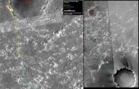
Route map, updated after "small step" on sol 776.
|
|
|
|
|
|
| Guest_Sunspot_* |
Mar 31 2006, 05:10 PM
Post
#1165
|
|
Guests |
Hopefully the next drive will be another long one ... it looks like they have a pretty clear path for quite some way ahead.
I'm also surprised at the size of the dunes..I was expecting them to be MUCH bigger. |
|
|
|
|
Mar 31 2006, 05:38 PM
Post
#1166
|
||
 Senior Member Group: Members Posts: 2173 Joined: 28-December 04 From: Florida, USA Member No.: 132 |
QUOTE (Tesheiner @ Mar 31 2006, 12:03 PM) Route map, updated after "small step" on sol 776.
They must have seen that they were out of line with your projected path and moved to correct the situation. 
|
|
|
|
|
|
|
Mar 31 2006, 06:51 PM
Post
#1167
|
|
|
Member Group: Members Posts: 252 Joined: 27-April 05 Member No.: 365 |
I wouldn't be surprised if, when they reach that large patch of exposed ground up ahead to the SSE, that they turn to the ESE and follow that sequence of exposed ground for a while. Only one line of slightly bigger dunes that can probably be dodged with a WNW jog for a day.
|
|
|
|
|
Mar 31 2006, 06:58 PM
Post
#1168
|
|
|
Member Group: Members Posts: 235 Joined: 2-August 05 Member No.: 451 |
QUOTE (Burmese @ Mar 31 2006, 01:51 PM) I wouldn't be surprised if, when they reach that large patch of exposed ground up ahead to the SSE, that they turn to the ESE and follow that sequence of exposed ground for a while. Only one line of slightly bigger dunes that can probably be dodged with a WNW jog for a day. I agree, though this feature is so straight, I wonder if it is some kind of ridge/fault line. |
|
|
|
| Guest_BillyMER_* |
Mar 31 2006, 08:46 PM
Post
#1169
|
|
Guests |
QUOTE (Sunspot @ Mar 31 2006, 12:10 PM) I'm also surprised at the size of the dunes..I was expecting them to be MUCH bigger. I commented on this idea a little while ago,the drive direction photos often look a lot rougher then what it turns out to be when they get there. |
|
|
|
|
Mar 31 2006, 08:57 PM
Post
#1170
|
||
 Member Group: Members Posts: 753 Joined: 23-October 04 From: Greensboro, NC USA Member No.: 103 |
QUOTE (Tesheiner @ Mar 31 2006, 12:03 PM) Route map, updated after "small step" on sol 776.
That's one small step for Opportunity...one...giant leap for Spirit. We'd be thrilled to see Spirit drive this far in a day now! -------------------- Jonathan Ward
Manning the LCC at http://www.apollolaunchcontrol.com |
|
|
|
|
|
|

|
Lo-Fi Version | Time is now: 25th April 2024 - 12:58 AM |
|
RULES AND GUIDELINES Please read the Forum Rules and Guidelines before posting. IMAGE COPYRIGHT |
OPINIONS AND MODERATION Opinions expressed on UnmannedSpaceflight.com are those of the individual posters and do not necessarily reflect the opinions of UnmannedSpaceflight.com or The Planetary Society. The all-volunteer UnmannedSpaceflight.com moderation team is wholly independent of The Planetary Society. The Planetary Society has no influence over decisions made by the UnmannedSpaceflight.com moderators. |
SUPPORT THE FORUM Unmannedspaceflight.com is funded by the Planetary Society. Please consider supporting our work and many other projects by donating to the Society or becoming a member. |
|