Journey to Mt Sharp - Part 3: Cooperstown to Kimberley - Waypoint 3, Sol 453 [Nov14,'13] to 595 [Apr9,'14] |

  |
Journey to Mt Sharp - Part 3: Cooperstown to Kimberley - Waypoint 3, Sol 453 [Nov14,'13] to 595 [Apr9,'14] |
 Mar 19 2014, 11:18 PM Mar 19 2014, 11:18 PM
Post
#736
|
|
|
Senior Member  Group: Members Posts: 3516 Joined: 4-November 05 From: North Wales Member No.: 542 |
QUOTE (CosmicRocker @ Feb 19 2014, 04:38 AM)  It certainly looks like an unconformity being exhumed at KMS-9, but it appears to me that it might be a disconformity rather than an angular unconformity. I suspect the striated unit may be largely flat-lying, but have significant erosional topography below the unconformity. What do you make of it now we're here? To me it looks like the striated unit is dipping downward into the crater whilst the overlying rocks are more horizontal, but I'd like to hear ideas either way. |
 |
 
|
|
Mar 20 2014, 12:06 AM
Post
#737
|
||
|
Solar System Cartographer Group: Members Posts: 10151 Joined: 5-April 05 From: Canada Member No.: 227 |
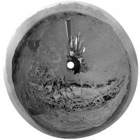
Wow, great site - so here's a circular version of Damia's new full panorama.
Phil
PS - just had the pleasure of meeting Fred Calef at LPSC, and I note that he just slipped in some new feature names between Darwin and Cooperstown in his map. Thanks, Fred! -------------------- ... because the Solar System ain't gonna map itself.
Also to be found posting similar content on https://mastodon.social/@PhilStooke Maps for download (free PD: https://upload.wikimedia.org/wikipedia/comm...Cartography.pdf NOTE: everything created by me which I post on UMSF is considered to be in the public domain (NOT CC, public domain) |
|
|
|
|
|
|
Mar 20 2014, 05:19 AM
Post
#738
|
|
|
Senior Member Group: Members Posts: 1043 Joined: 17-February 09 Member No.: 4605 |
QUOTE (ngunn @ Mar 20 2014, 12:18 AM) ... To me it looks like the striated unit is dipping downward into the crater whilst the overlying rocks are more horizontal.... Indeed it does and it would be interesting to get one of the sedimentologist's take on this. Gale is old and Mount Sharp represents a heck of a mass, so I guess some local deformation and inwards inclination of initially planar beds could have occurred. On the other hand your description is not a bad generalisation of foreset and topset beds. |
|
|
|
|
Mar 20 2014, 07:03 AM
Post
#739
|
|
 Member Group: Members Posts: 809 Joined: 3-June 04 From: Brittany, France Member No.: 79 |
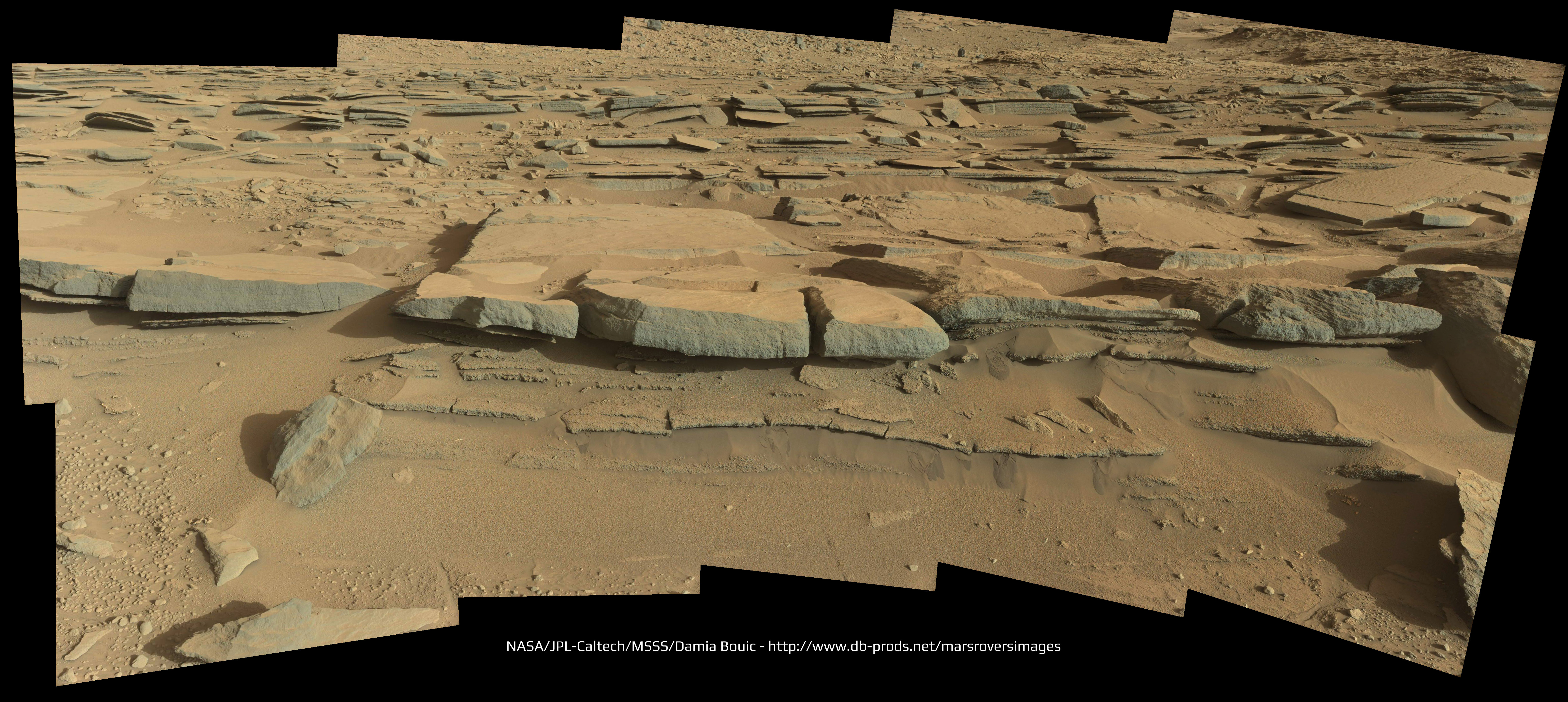
Mosaic of MastCam 34mm images taken on sol 574 (to be completed). Right: false colors and contrast stretched. What a promising outcrop!
 
-------------------- |
|
|
|
|
Mar 20 2014, 10:07 AM
Post
#740
|
|
 Senior Member Group: Members Posts: 1619 Joined: 12-February 06 From: Bergerac - FR Member No.: 678 |
And my take :
-------------------- |
|
|
|
|
Mar 20 2014, 05:04 PM
Post
#741
|
|
 Senior Member Group: Members Posts: 2228 Joined: 1-December 04 From: Marble Falls, Texas, USA Member No.: 116 |
QUOTE (ngunn @ Mar 19 2014, 06:18 PM) What do you make of it now we're here? To me it looks like the striated unit is dipping downward into the crater whilst the overlying rocks are more horizontal, but I'd like to hear ideas either way. I didn't have time to look at the imagery last night, but I just looked at it now and I think you are right...the beds are clearly dipping. I began to suspect this after Emily posted her very helpful topographic map a while ago, but I wanted to see the ground truth before commenting. Good job, sir.  I'm really looking forward to seeing a lot more of this interesting area. Hopefully we can figure out if this dip is deformational or depositional. It's unfortunate that just as we arrive at one of the most interesting places so far, we have these changes taking place in the file naming conventions that could throw at least a temporary monkey wrench into our most useful image viewing tools. -------------------- ...Tom
I'm not a Space Fan, I'm a Space Exploration Enthusiast. |
|
|
|
|
Mar 20 2014, 10:13 PM
Post
#742
|
|
 Member Group: Members Posts: 404 Joined: 5-January 10 Member No.: 5161 |
Threw together latest hazcam sequences:

|
|
|
|
|
Mar 21 2014, 12:52 AM
Post
#743
|
|
|
Solar System Cartographer Group: Members Posts: 10151 Joined: 5-April 05 From: Canada Member No.: 227 |
News flash from LPSC - just saw a new HiRISE, not released yet, with Curiosity's tracks going through Dingo Gap. Cool.
Phil -------------------- ... because the Solar System ain't gonna map itself.
Also to be found posting similar content on https://mastodon.social/@PhilStooke Maps for download (free PD: https://upload.wikimedia.org/wikipedia/comm...Cartography.pdf NOTE: everything created by me which I post on UMSF is considered to be in the public domain (NOT CC, public domain) |
|
|
|
|
Mar 21 2014, 05:47 AM
Post
#744
|
|
 Administrator Group: Admin Posts: 5172 Joined: 4-August 05 From: Pasadena, CA, USA, Earth Member No.: 454 |
Yeah I saw that in Nathan Bridges' talk. It was totally beautiful. Taken in February sometime.
Also, I learned today (maybe we knew this before and I just didn't notice) that the RMI and M-100 images of the base of Mt Sharp are taken at Nathan Bridges' behest, in order to look for motion on the ripples atop the basaltic sand dunes. He said he had not seen any such motion yet. He said that the early M-100 images that they got of the base of the mountain that were lossless (sol 20-something) were terrific but that more-compressed images were a little harder to use to try to match ripple features. He said that he was advocating for more lossless M-100 images to try to image dune ripples to look for motion. -------------------- My website - My Patreon - @elakdawalla on Twitter - Please support unmannedspaceflight.com by donating here.
|
|
|
|
|
Mar 21 2014, 11:23 AM
Post
#745
|
|
 Member Group: Members Posts: 796 Joined: 27-February 08 From: Heart of Europe Member No.: 4057 |
These are really fantastic layered rocks. Thanks Thomas and Damia for your mosaics!
-------------------- |
|
|
|
|
Mar 21 2014, 12:18 PM
Post
#746
|
|
 Senior Member Group: Members Posts: 2492 Joined: 15-January 05 From: center Italy Member No.: 150 |
QUOTE (walfy @ Mar 20 2014, 11:13 PM) Threw together latest hazcam sequences: Great 3D animation! The Kimberley layers recalls me an ancient amphitheatre...  -------------------- I always think before posting! - Marco -
|
|
|
|
|
Mar 21 2014, 03:43 PM
Post
#747
|
|
|
Member Group: Members Posts: 809 Joined: 3-June 04 From: Brittany, France Member No.: 79 |
Mosaic made with Right NavCam. Nice view
-------------------- |
|
|
|
|
Mar 21 2014, 04:37 PM
Post
#748
|
|
 Member Group: Members Posts: 691 Joined: 21-December 07 From: Clatskanie, Oregon Member No.: 3988 |
Here is my version
|
|
|
|
|
Mar 21 2014, 06:23 PM
Post
#749
|
|
|
Senior Member Group: Members Posts: 1619 Joined: 12-February 06 From: Bergerac - FR Member No.: 678 |
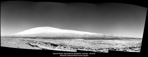
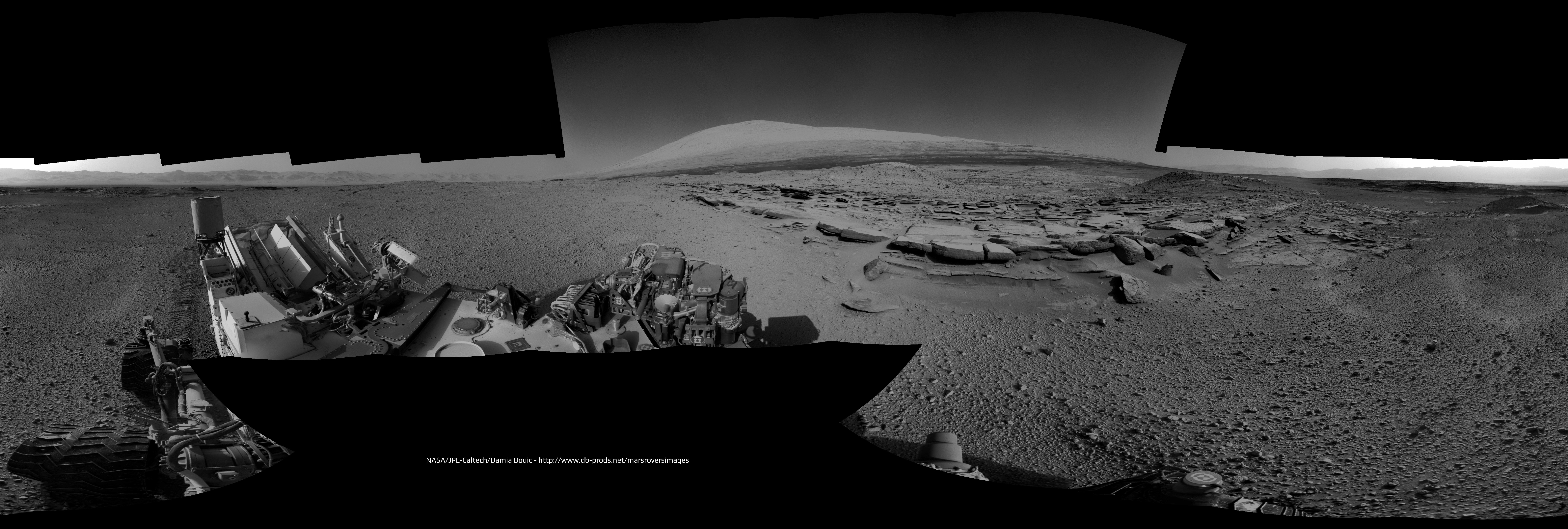
Updated version of Sol 574 Navcam with Mount Sharp pics taken on Sol 576. Now it's a full pan
-------------------- |
|
|
|
|
Mar 22 2014, 04:12 PM
Post
#750
|
|
|
Senior Member Group: Members Posts: 1619 Joined: 12-February 06 From: Bergerac - FR Member No.: 678 |
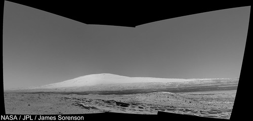
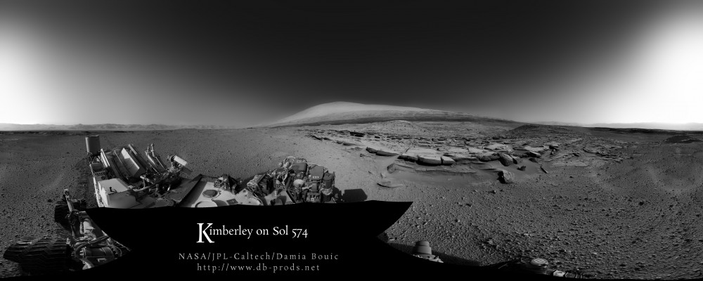
And how about in Postcard version ? ^^
-------------------- |
|
|
|
|

|
Lo-Fi Version | Time is now: 25th April 2024 - 03:57 AM |
|
RULES AND GUIDELINES Please read the Forum Rules and Guidelines before posting. IMAGE COPYRIGHT |
OPINIONS AND MODERATION Opinions expressed on UnmannedSpaceflight.com are those of the individual posters and do not necessarily reflect the opinions of UnmannedSpaceflight.com or The Planetary Society. The all-volunteer UnmannedSpaceflight.com moderation team is wholly independent of The Planetary Society. The Planetary Society has no influence over decisions made by the UnmannedSpaceflight.com moderators. |
SUPPORT THE FORUM Unmannedspaceflight.com is funded by the Planetary Society. Please consider supporting our work and many other projects by donating to the Society or becoming a member. |
|