Printable Version of Topic
Click here to view this topic in its original format
Unmanned Spaceflight.com _ MSL _ Journey to Mt Sharp - Part 5: Into the Valleys
Posted by: fredk Aug 1 2014, 04:15 PM
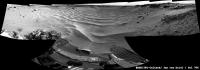
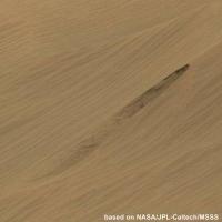
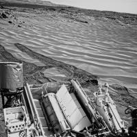
Toe-dip into the Hidden Valley ripples on 706:
http://mars.jpl.nasa.gov/msl-raw-images/proj/msl/redops/ods/surface/sol/00706/opgs/edr/fcam/FLB_460172740EDR_F0400200FHAZ00302M_.JPG
...Maybe a good time for a new thread?
Posted by: elakdawalla Aug 1 2014, 04:25 PM
I think it's time for a new topic! It looks like we have indeed arrived in Hidden Valley, ending the southward drive from the Kimberley. It's time to take a right turn, heading west-southwest in valley floors, paralleling the black basaltic dunes, until we reach Murray Buttes.
Posted by: walfy Aug 1 2014, 05:33 PM
Descent into the valley!
|
Posted by: anticitizen2 Aug 1 2014, 05:59 PM
The subtitle gave me goosebumps
http://imgur.com/a/k9U8p#0
http://imgur.com/a/VzYuh#0
Posted by: elakdawalla Aug 1 2014, 06:11 PM

Just investing this adventure with the drama it deserves

Posted by: djellison Aug 1 2014, 07:22 PM
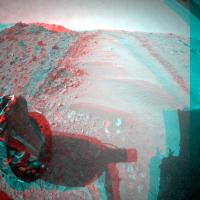
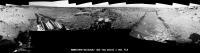
705 Toe Dip!
(Full Size - http://dougellison.smugmug.com/Landscapes/Curiosity/i-QRFgw57/O )
|
Posted by: nprev Aug 1 2014, 07:41 PM
What a scene!!! That big layered guy with the white highlight at 1 o'clock from the POV is just begging for a close-up...the surrounding dunes look a bit forbidding, though.
Posted by: jmknapp Aug 1 2014, 07:54 PM
Not much slippage per the http://curiosityrover.com/tracking/speedplot.php?drivenum=223 and the track above looks good.
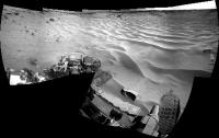
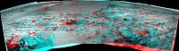
Posted by: Ant103 Aug 1 2014, 08:10 PM
My take on this wonderful view
http://www.db-prods.net/marsroversimages/Curiosity/2014/Sol706_pano.jpg
Posted by: CosmicRocker Aug 2 2014, 05:02 AM
It looks like we made a favorable "first impression."
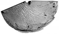
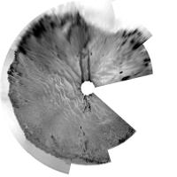
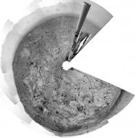
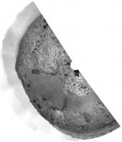
Posted by: Phil Stooke Aug 2 2014, 03:44 PM
This is a circular version of Damia's mosaic from sol 706.
Phil
|
Posted by: mhoward Aug 2 2014, 04:32 PM
I think you nailed the title. I'm going to borrow that one, if you don't mind.
Posted by: elakdawalla Aug 2 2014, 04:41 PM
Considering just how much I'm relying on your website for my book, I certainly don't mind!
Posted by: Phil Stooke Aug 2 2014, 05:17 PM
This is the sol 705 pan from the most recent press release, in circular form.
Phil
|
Posted by: mhoward Aug 2 2014, 10:09 PM
Thanks; it's good to know that it's useful.
Posted by: craigmcg Aug 3 2014, 12:23 PM
I seems appropriate that Curiosity will be spending much of August on the beach.
Posted by: elakdawalla Aug 4 2014, 05:16 PM
I moved several wheel-related posts to the http://www.unmannedspaceflight.com/index.php?showtopic=7658 thread.
Posted by: elakdawalla Aug 4 2014, 08:10 PM
Hmmm. http://www.midnightplanets.com/web/MSL/sol/00709.html. If it is, it doesn't look as excessive as the one back on http://www.midnightplanets.com/web/MSL/sol/00672.html.
Posted by: fredk Aug 4 2014, 08:33 PM
I suppose this will be the kind of view we have for a while...
http://mars.jpl.nasa.gov/msl-raw-images/proj/msl/redops/ods/surface/sol/00709/opgs/edr/ncam/NRB_460434308EDR_F0400366NCAM05694M_.JPG
Sure makes you appreciate the usefulness of orbital imagery.
Posted by: PDP8E Aug 4 2014, 08:56 PM
what is this little valley?
ancient riverbed? (will there be cobbles in the banks?)
a rift?
just wondering...
Posted by: jvandriel Aug 4 2014, 09:01 PM
Sol 706
Hidden Valley
Jan van Driel
|
Posted by: PaulH51 Aug 4 2014, 10:14 PM
The drive distances published by Joe and Midnight Planets (MP) are rarely aligned as MP reports point-to-point movement, with Joe reporting the drive distance using NAIF wheel turn data that includes donuts during the drive. Looking at the images we have so far, the sol 709 drive appears straight with one partial donut (turn) at the beginning of the drive. Comparing the distances 14.1m by MP and 26m from Joe along with the spacing of the marks left by the cleats in the wheel track it appears we have had some slip, but apparently not enough to trigger a halt in the drive which looks like good news for a traverse through these valley systems. I note that this drive took the rover closer to the southern wall of the valley, HiRISE images suggest the ripples are smaller on that side of the valley I wonder if they would offer less slip? Or it could just be that the southern wall is not as steep as the north wall and could be used to exit the floor if required.
Posted by: Gerald Aug 4 2014, 11:09 PM
Part of http://www.jpl.nasa.gov/news/news.php?release=2014-257&rn=news.xml&rst=4241 sounds almost like the announcement of a waypoint:
Posted by: elakdawalla Aug 4 2014, 11:21 PM
Hmmmmm. I'd buy that. "Appetizer" sounds like they're thinking about eating something
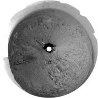
Posted by: Phil Stooke Aug 5 2014, 12:22 AM
My interpretation of the final waypoint from the original waypoint map was that it was on this same valley floor unit, so I think this may just be the first exposure of the same unit along this new path.
Phil
Posted by: jmknapp Aug 5 2014, 01:31 AM
Check the http://curiosityrover.com/tracking/speedplot.php?drivenum=225t from this drive--it looks like maybe slip detection kicked in at t=1850. The way I'm interpreting such data anyway is that spikes of more than a few cm/sec represent slip, and those usually occur (if they do) at the beginning of a drive pulse (makes sense I guess). Usually the slip is short-lived and the rover continues forward but at 1850 there's no action after the big pulse of 45 cm. That's still just a fraction of a rotation of the wheel. But then it seems to proceed OK. There was some zig-zagging at the end, at least according to the raw SPICE data:

|
Never sure how much to take that as gospel though.
Posted by: Phil Stooke Aug 5 2014, 01:49 AM
A very rough circular view to get our current location:
|
Phil
Posted by: Gerald Aug 5 2014, 09:27 AM
The time for the pause seems to match with http://mars.jpl.nasa.gov/msl-raw-images/proj/msl/redops/ods/surface/sol/00709/opgs/edr/ncam/NLB_460433300EDR_F0400320NCAM00479M_.JPG. So I'm considering, that the stop (at t=1850) has been intentional to do some imaging.
The last driving phase took about 600s, like the one before. This gives me some hope, that the termination of the drive hasn't been triggered by slipping, presuming periodic imaging stops.
But when http://mars.jpl.nasa.gov/msl-raw-images/proj/msl/redops/ods/surface/sol/00709/opgs/edr/fcam/FRB_460434063EDR_F0400366FHAZ00302M_.JPG (driving backward), there may be an augmented risk of excessive slippage.
Posted by: Gerald Aug 5 2014, 11:50 AM
http://mars.jpl.nasa.gov/msl-raw-images/msss/00708/mrdi/0708MD0002990000102254E01_DXXX.jpg in an enhanced version, to provide a look to the ground:
http://imgur.com/ZpCc1E2
(and to indicate, how beautiful MARDIs can look, sometimes)
Posted by: anticitizen2 Aug 5 2014, 05:30 PM
http://i.imgur.com/3zCrMML.gif - watch the lengthening shadows
http://i.imgur.com/q6i7EXw.gif

 http://i.imgur.com/ngVmC38.gif
_____________________________________________________________________________
EDIT: 710 is starting to come down
http://i.imgur.com/KZ9Quga.gif - http://i.imgur.com/ddJaNTV.gif
Posted by: Gerald Aug 5 2014, 08:30 PM
The puzzle about the slippage has been resolved by http://astrogeology.usgs.gov/news/astrogeology/sol-710-update-on-curiosity-from-usgs-scientist-ken-herkenhoff-deep-tracks:
So the criteria in this case seems to have been the overall progress in contrast to a short-term excessive slippage.
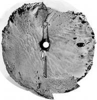
Posted by: jvandriel Aug 5 2014, 08:33 PM
The Navcam view on Sol 709.
Jan van Driel
|
|
Posted by: Phil Stooke Aug 5 2014, 09:55 PM
... and a circular view of it - thanks, Jan!
Phil
|
Posted by: fredk Aug 6 2014, 02:01 AM
Have we seen flatfielded images on the jpl jpeg site before?
http://mars.jpl.nasa.gov/msl/multimedia/raw/?s=710&camera=CHEMCAM%5F
Posted by: James Sorenson Aug 6 2014, 02:55 AM
Those images are not flat-fielded. But I do see possible sky-flats that can be turned into rough flat-fields . Those type of images appear like all others on the raw page. You will not see of coarse calibrated images that have been flat-fielded. Those have to wait until they hit the PDS.
Posted by: fredk Aug 6 2014, 03:06 AM
Compare these two images:
http://mars.jpl.nasa.gov/msl-raw-images/proj/msl/redops/ods/surface/sol/00710/opgs/edr/ccam/CR0_460535055EDR_F0400480CCAM15024M_.JPG
http://mars.jpl.nasa.gov/msl-raw-images/proj/msl/redops/ods/surface/sol/00710/soas/rdr/ccam/CR0_460535055PRC_F0400480CCAM15024L1.JPG
It's clear the second one is a flatfielded version of the first. The filenames differ only in the text codes (EDR vs PRC and M_ vs L1). The paths are also different.
I don't recall anything like this before. Either a glitch or a new policy (hopefully the latter!).
Posted by: James Sorenson Aug 6 2014, 03:11 AM
Oh wow! I didn't scroll down far enough to see that! You are right, those have been flat-fielded in the enhanced section. That is interesting!
Posted by: elakdawalla Aug 6 2014, 03:34 AM
OOOOOOOOOO!
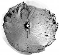
Posted by: jvandriel Aug 6 2014, 02:41 PM
The Navcam L panoramic view on Sol 710.
Jan van Driel
|
|
Posted by: Gerald Aug 6 2014, 03:02 PM
It's RDRs -- in PNG format -- in addition to EDR JPGs, great! It makes RMI images much easier to use.
Posted by: fredk Aug 6 2014, 03:03 PM
What about tip-toeing around the edge
It looks like driving along the edges is indeed the plan acording to this release:
http://mars.jpl.nasa.gov/msl/multimedia/videos/index.cfm?v=209
Posted by: fredk Aug 6 2014, 03:11 PM
Yeah - there was a good argument to be made for providing flatfielded images, since this camera suffers from such severe vignetting and typically clipping near the centre in the jpl jpegs. But png is icing on the cake!
Posted by: anticitizen2 Aug 6 2014, 04:08 PM
I combined the 709-710 out and back drives
http://i.imgur.com/xYtqBBB.gif - http://i.imgur.com/ng8nW76.gif
http://i.imgur.com/eWU3lmC.gif - http://i.imgur.com/h6pcL0H.gif
http://i.imgur.com/GF7szkx.gif - http://i.imgur.com/y5a75oA.gif
Posted by: Phil Stooke Aug 6 2014, 04:15 PM
Jan's sol 710 pan in circular format. Thanks, Jan.
Phil
|
Posted by: anticitizen2 Aug 6 2014, 07:12 PM
Ok, I'm a little nervous
http://mars.jpl.nasa.gov/msl/multimedia/raw/?s=711&camera=MAHLI
http://i.imgur.com/OYSYhA9.gif - http://i.imgur.com/4mWfEzE.gif
|
Posted by: SpaceListener Aug 6 2014, 07:34 PM
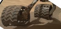
I am surprised to see the sand marked by the wheels of the rover so dark. It looks like that the under surface is wet for the so arid zone. I am supposing that the sand under surface would be about the same colour as the surface ones.
Posted by: algorithm Aug 6 2014, 07:34 PM
This baby probably has more torque per (Something!) than a Bugatti Veyron, so if you can see the axle then everything is probably cool.

Posted by: fredk Aug 6 2014, 08:26 PM
We've seen this before - I guess it's just that the top surface has a coating of the ubiquitous light coloured dust.
Posted by: RoverDriver Aug 7 2014, 02:28 AM
About 740 ft lb. About three times my car has.
Paolo
Posted by: xflare Aug 7 2014, 08:33 AM
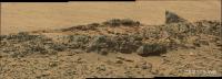
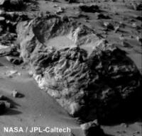
Impressive layering - SOL 710
|
Posted by: Astro0 Aug 7 2014, 09:11 AM
Why am I hearing the theme to Jaws again? 
Posted by: anticitizen2 Aug 7 2014, 01:48 PM
Stirling has now been run over a few times
http://i.imgur.com/Q9AOWkb.gif - http://i.imgur.com/QX5U2BK.gif
Lots of large sandy walls, plenty of opportunities to spot material slides
http://mars.jpl.nasa.gov/msl-raw-images/msss/00710/mcam/0710MR0030160070402525E01_DXXX.jpg
Can't wait to see the valleys post-Curiosity with HiRISE
Posted by: algorithm Aug 7 2014, 07:28 PM
Impressive indeed.

|
Posted by: jvandriel Aug 7 2014, 07:43 PM
Sol 711
2 ChemCam images stitched together.
Jan van Driel
|
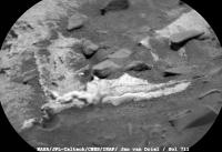
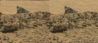
Posted by: atomoid Aug 7 2014, 08:45 PM
the fin lurks yonder (crosseye)
|
Posted by: climber Aug 8 2014, 10:23 AM
Paolo
Is this yet another new Nasa measurement unit ?


Posted by: serpens Aug 8 2014, 01:58 PM
Foot pounds? I thought given the US membership of BIPM and the fate of the Mars Polar Orbiter the MKS system would be compulsory in all mission aspects?
Posted by: jvandriel Aug 8 2014, 02:51 PM
The Navcam L view on Sol 711.
Jan van Driel
|
|
Posted by: RoverDriver Aug 8 2014, 09:26 PM
Yes, the actual specs say 1000 Nm. I converted to ft lb since most of the US readers are probably familiar with that unit.
Paolo
Posted by: anticitizen2 Aug 8 2014, 09:55 PM
Back out of the valley!
http://i.imgur.com/DmkA36H.gif
From the http://astrogeology.usgs.gov/news/astrogeology/sol-713-update-on-curiosity-from-usgs-scientist-ryan-anderson-high-road-or-low-road-, it sounds like there has been a lot of staring at HiRISE images over the last few days
Posted by: serpens Aug 8 2014, 10:42 PM
Is this a case of a reverse Kipling "Out of the valley of death rode the 600"?
Posted by: mcaplinger Aug 8 2014, 11:04 PM
I thought they had done a lot of testing of driving on sand, so to be concerned about it seems odd. Is there something unusual about this particular sand?
Posted by: fredk Aug 8 2014, 11:25 PM
Posted by: anticitizen2 Aug 8 2014, 11:32 PM
Right, but the strategic planning had been through the valleys - I was guessing they didn't have a solid "next best route" over the terrain they were trying to avoid beginning at the Hidden Valley entrance.
It wasn't any serious analysis, just a comment to relieve some anxiety over the 180
I hope they show some of the shredded wheels from the Mars Yard still functioning to reassure wheel-worriers
Posted by: Explorer1 Aug 9 2014, 12:11 AM
Wasn't the plan to drive as close to the cliff edge as possible, so that there was solid ground right underneath in case of slippage? I'm sure it was mentioned in one of the earlier posts but I can't find it now...
Posted by: fredk Aug 9 2014, 12:14 AM
Yep - check out http://www.unmannedspaceflight.com/index.php?s=&showtopic=7868&view=findpost&p=211771 I guess it's still a question of what the ground is like near the sides - in particular, how steep is it?
Posted by: jmknapp Aug 9 2014, 01:02 AM
Though perhaps all it would take is one little divot with deeper sand the catch a wheel?
As reported over the last months, that category would include much of the mission team.
Wouldn't envy the person who signs off on the plan to go into the sand drifts though. Better the devil you know? BTW, here's the egress:
http://curiosityrover.com/tracking/drivetrack.php?drivenum=228
Posted by: elakdawalla Aug 9 2014, 03:49 AM
I did not have the impression they expected so much slip on the sand in these valleys. They crossed Dingo Gap with little problem. At the same time, it does seem to me that they were making enough progress and almost all the way through the ripples on sol 709 that it seems like they should've made it if they kept going -- but that clearly wasn't good enough.
Apparently https://twitter.com/ColetteLohr/status/497940606673383424 as I type. Sometimes Mars is hard.
Posted by: Gerald Aug 9 2014, 01:17 PM
of http://astrogeology.usgs.gov/news/astrogeology/sol-713-update-on-curiosity-from-usgs-scientist-ryan-anderson-high-road-or-low-road-.
My guess would be, after looking at features like this funnel(?)
|
(Sol 710) they'll prefer taking the predictable and manageable risk of Zabriskie plateau over the fuzzy risk of the sand.
Posted by: Bubbinski Aug 9 2014, 05:08 PM
If they have to go out of Hidden Valley, where is the point on the Zabriskie plateau where the "caprock" ends? And are they going to still try to reach that nearby outcrop they think is Mt. Sharp material? (Pahrump Hills as mentioned a couple of pages back)
Posted by: marsophile Aug 9 2014, 05:30 PM
Is there a third alternative? Perhaps the dark sands of the "moat" (if I may call it that) below Mount Sharp might be more stable than the light sands in Hidden Valley?
Posted by: fredk Aug 9 2014, 05:36 PM
I've wondered about the dark sands too. Looking at the orbital imagery, there actually looks like a finger of the dark sands reaching into a southern fork of Hidden Valley, only a couple hundred metres to our south. But the problem with that might be that if the dark sands are found to be not traversable, then you may have to do substantial backtracking to avoid them.
Isn't back seat driving so much fun?
Posted by: Gerald Aug 9 2014, 07:55 PM
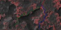
Based on a screenshot of http://curiosityrover.com/rovermap1.html (basing on HiRISE/SPICE in this screenshot), here a version enhancing (radius 2) hipass features as red:
|
Hipass features should correlate to surface roughness, although using a DTM would be more appropriate.
I wouldn't rule out, that there may exist routes avoiding the Hidden Valley, but still reaching to the nearby outcrop. I've marked the beginning of two such out-of-the-hip route candidates, both not free of risk.
Posted by: Bubbinski Aug 9 2014, 08:42 PM
Thanks Gerald! That green route looks like it passes too close to the valley edge for comfort (having a nightmare vision of a tumbling rover).
Posted by: CosmicRocker Aug 9 2014, 08:48 PM
I just wanted to make everyone aware of the fact that next week (Aug. 14 & 15) there will be a http://www.jpl.nasa.gov/events/lectures_archive.php?year=2014&month=8 about Curiosity's second year on Mars. It bears the intriguing title "Curiosity's Second Year: The Epic and Occasionally Bogus Journey to the Foothills of Mt. Sharp."
The lecture will be in Pasadena, CA, but it looks like it will also be webcasted on Ustream.
Posted by: Bubbinski Aug 9 2014, 09:45 PM
Just took a look at sol 714 raw images. Looks like they're on the plateau and away from Hidden Valley entirely.
Posted by: ngunn Aug 9 2014, 10:56 PM
It seems there are many different types of sand drift on Mars. Some are solid enough you could just about cut steps with your boots while on others you're immediately up to your thighs. I wonder if it has to do with how long they've been immobile (I mean the dark sand, not the rusty dust on top)?
Posted by: fredk Aug 10 2014, 01:17 AM
Yeah, and I can't imagine why we'd drive this far out of HV if the valley route was still considered an option:
http://mars.jpl.nasa.gov/msl-raw-images/proj/msl/redops/ods/surface/sol/00714/opgs/edr/ncam/NRB_460883975EDR_F0401000NCAM00264M_.JPG
Posted by: jvandriel Aug 10 2014, 12:44 PM
The Navcam view on Sol 713.
Jan van Driel
|
Posted by: James Sorenson Aug 11 2014, 12:04 AM
An apparent radiation storm? A whole sequence of Rear Hazcam images with salt and pepper noise. Sol-710
http://mars.jpl.nasa.gov/msl-raw-images/proj/msl/redops/ods/surface/sol/00710/opgs/edr/rcam/RRB_460532965EDR_F0400480RHAZ00233M_.JPG
Posted by: fredk Aug 11 2014, 02:56 AM
It looks to me like the extra noise you see when longer exposures are taken. But this sequence was just after 3pm local time, when you shouldn't need long exposures.
Posted by: nprev Aug 11 2014, 03:46 AM
Lossy uplink due to a poor look angle? They've begin moving orbiters around in preparation for the comet encounter, I believe.
Could be a few things, though.
Posted by: Phil Stooke Aug 11 2014, 04:56 AM
Here is a circular view of sol 714's location. Looks like we may drive across that outcrop and into "Neil Armstrong's footpint" as it was described earlier.
Phil
|
Posted by: anticitizen2 Aug 11 2014, 03:13 PM
http://i.imgur.com/6OAk8dH.jpg - http://i.imgur.com/YCHhIvK.jpg
http://imgur.com/a/CuOpt#0 looking across the valley and at the 'bootprint' - http://imgur.com/a/lYIme#0
Posted by: fredk Aug 11 2014, 04:01 PM
The noise in rhaz can't be cosmic rays or lossy uplink, because the bright pixels are at the same position sols apart - compare, eg, these frames:
http://mars.jpl.nasa.gov/msl-raw-images/proj/msl/redops/ods/surface/sol/00710/opgs/edr/rcam/RLB_460533007EDR_F0400480RHAZ00233M_.JPG
http://mars.jpl.nasa.gov/msl-raw-images/proj/msl/redops/ods/surface/sol/00714/opgs/edr/rcam/RLB_460882792EDR_F0401000RHAZ00311M_.JPG
My guess is, given the location of rhaz, radiation damage to the CCD from the RTG. It's been gradually getting worse, but is more noticable with longer exposures.
Given the fixed nature of the damage, it should be easy to code a filter to remove the hot pixels quite effectively.
Posted by: algorithm Aug 11 2014, 05:46 PM
My first attempt at making a HDR version of an image.
The original NavCam image from sol 713

|
and the 'HDR' version.
|
I chose this image at random so it may produce better results on others, I do think it has definitely brought out some 'hidden' details in certain areas though.
Posted by: elakdawalla Aug 11 2014, 05:54 PM
I encourage people interested in this kind of processing to return to the PDS versions of images once they become available, because the data in the PDS have much higher bit depth to begin with.
Posted by: jvandriel Aug 11 2014, 06:24 PM
The Navcam panoramic view on Sol 714.
Jan van Driel
|
|
Posted by: algorithm Aug 11 2014, 06:35 PM
I thought I would try the same thing on a colour image.
Original pan
|
|
HDR version
|
|
It seemed to work better in some areas than others.
I think I'll practice a bit more.
Posted by: fredk Aug 11 2014, 06:53 PM
What exactly do you mean by "HDR"? Normally HDR means combining different exposures (or perhaps starting with higher than 8 bpp bitdepth). But for these images we only have single 8 bpp frames available so far. Maybe you're just doing a levels/gamma adjustment?
Posted by: algorithm Aug 11 2014, 07:05 PM
Adjust the exposure settings up and down by equal ammounts(stops) saving each as a separate file then recombining as a single enhanced HDR image.
Posted by: djellison Aug 11 2014, 07:35 PM
Why bother going thru that process? Just load the single image into, say, Photomatix and work with it there. You're just tone-mapping an 8-bit image - there's nothing to be gained from trying to fake different exposures.
Posted by: mcaplinger Aug 11 2014, 07:52 PM
Technically this isn't salt and pepper noise because there are no dark pixels, only bright ones. (No pepper, only salt.) So these are unlikely to be transmission errors (they couldn't be anyway because image compression causes transmission errors to look completely different) but hot pixels. Hot pixels are worse with longer exposure and with higher camera head temperature.
As noted the rear hazcams are closer to the RTG and also to the other neutron source on the rover, DAN.
Posted by: algorithm Aug 11 2014, 07:59 PM
Fortunately I don't have a clue what you are talking about.
Seems like my HDR days are over though.
Posted by: djellison Aug 11 2014, 08:35 PM
Not questioning the results - just wondering what your pipeline is that requires making faked +/-ev pictures first.
Posted by: atomoid Aug 11 2014, 09:10 PM
yes i do like the nice HDR-ish contrast enhancements resulting from algorithm's approach, its hard to say whether or not photoshop level adjustments on a single image wouldn't be capable of producing identical results.
Nice dry mass-wasting example on http://www.midnightplanets.com/web/MSL/image/00712/0712MR0030300290402561E01_DXXX.html, this 'micro-RSL' most reminiscent of the large-scale variety popularly misconceived as brine flows..
Posted by: scalbers Aug 11 2014, 09:26 PM
I thought HDR (high dynamic range) would generally reduce the contrast of the features from multiple images to fit the brightness range of a single image. Or as I gather from the above, some type of contrast adjustment or hi-pass filtering (i.e. tone mapping), done as pseudo-HDR on a single original image? I can follow the point that the post-processing normally done with merged images might still enhance the equivalent of a single image.
Posted by: djellison Aug 11 2014, 11:46 PM
There are two HDR techniques. One is simply exposure fusion - compressing multiple exposures to capture detail in both highlight and shadow regions of photographs.
The other is tone mapping- this, at some given radius, adjusts the brightness/contrast/gamma etc of the image area by area such that everywhere can express more detail (i.e. brighten areas in shadow to see detail there, darken areas like skies to see detail in clouds)
I dabble in landscape photography and I'm pretty fond of what the latter, done with a little subtlety, can do.
http://dougellison.smugmug.com/Landscapes/Fonts-Point/i-3hKxSfc/A
Posted by: brellis Aug 12 2014, 01:28 AM
It has been a little over one earth year since MSL http://www.universetoday.com/103319/curiosity-rover-embarks-on-epic-trek-to-mount-sharp/, traveling about (edit: 7km) "as the rover drives" across the plains to her current location.
From the July 2013 article:
Mount Sharp lies about 5 miles (8 kilometers) distant – as the Martian crow flies.
And Curiosity must also pass through a potentially treacherous dune field to get there.
I'm happy to leave it to more qualified UMSFers to estimate the current distance to Mt. Sharp "as the crow flies".
btw, big thanks to nogal for providing the wonderful http://www.unmannedspaceflight.com/index.php?s=&showtopic=7442&view=findpost&p=212007!
For those of us (like me) who always have it in the back of our minds how cool it'd be to see how high and far MSL can climb up Mt. Sharp - MSL's driving distance is encouraging news. Big congrats to the drivers! Given that the power supply has a good decade of life left, there's plenty of time to dilly-dally around with all that science stuff in the process
though I must confess to having a great deal of Curiosity about the terrain MSL will be crossing in the ongoing journey to Mt Sharp! (p.s. - I still like http://en.wikipedia.org/wiki/Aeolis_Mons)
Posted by: lyford Aug 12 2014, 05:46 AM
Friends -
De-lurking after many moons to just ask if anyone has commented on the darker streaks we have seen http://www.midnightplanets.com/web/MSL/image/00712/0712MR0030300290402561E01_DXXX.html? I scrolled through some past posts but I may have missed it. I know it may just be a slump or darker sand being funneled down but it sure reminds me of some other Martian imagery with darker streaks down crater or canyon walls.... 
Anyway, back to the being quiet and contributing to the healthy s/n ratio. 
Lyford
Posted by: Explorer1 Aug 12 2014, 06:34 AM
Lyford: See atomoid's post a bit above yours...
Incidentally, it might be time to change the title of the thread, given the results of the planners' cost-benefit analysis: acceptable wear on wheels vs. a non-zero chance of getting permanently mired. There's still the big dunes to the south to test; they might be very passable.
Posted by: Gerald Aug 12 2014, 10:38 AM
We don't know yet the route. Maybe they'll just take a deviation of 200m around the Hidden Valley (and some of the rough terrain immediately north of it), to descend again.
Posted by: Actionman Aug 12 2014, 10:56 AM
Lyford
This is new find for MSL. It looks to be the same a color as subsurface sand which would lead to the expectation of this "flow" would be on top of the common harder lighter crusty surface layer.
Posted by: algorithm Aug 12 2014, 08:22 PM
The only 'pipeline' I have is Photoshop.
I understand from other posts that the images on the Nasa website are only 8-Bit, so it's obviously not the best start.
If I take a photo with my D-SLR and use the Bracketing option, does the camera not create pictures of the same scene but with different exposure values, which I can combine later to create a HDR image?
My thinking was to replicate this, although as Emily pointed out, using PDS images would be preferable.
If I used the same approach but with better images, would this produce any better results?
Plus, rather than using software designed to do the job required for me, rather prevents me from becoming a more acomplished Photoshop user.
BTW. I don't have a low opinion of Shareware/Freeware, I've used plenty of it over the last 23 years, (Remeber PaintShop Pro?
)but I have Photoshop now. So There!!(Stomp Stomp, throws toys away etc) BTWBTW. Followed the link - Nice. (Could have done with more at the end of all that lead-in though)
Posted by: charborob Aug 12 2014, 08:34 PM
You can use PhotoShop to combine several images with different exposures in order to produce a HDR image, but you can also use PhotoShop to apply HDR toning on a single image. (Don't ask me how the software does it, but you can fiddle with various settings.) I found that it works pretty well on some images, but not all. Like they say, your mileage may vary.
Posted by: djellison Aug 12 2014, 09:01 PM
That's exactly what it does - and that's what I do to start down the road of making HDR images myself. By under-exposing, for example, you get more detail out of a bright window. By over exposing, you get more detail in the shadows. Stack'em'all up and magic occurs
There is some merit to doing it with the 12 bit imagery from the PDS - but it's going to be pretty limited with the 8 bit JPG's that are already clipping top and bottom.
But - tone mapping - the adaptive brightness/contrast control applied to a single image - that's one way to get 'more detail' out of a single image.
Posted by: scalbers Aug 12 2014, 10:39 PM
Sol 717 back to the Hidden Valley entrance?
http://astrogeology.usgs.gov/news/astrogeology/sol-717-update-on-curiosity-from-usgs-scientist-ryan-anderson-vantage-point
Posted by: ap0s Aug 12 2014, 10:57 PM
http://astrogeology.usgs.gov/news/astrogeology/sol-717-update-on-curiosity-from-usgs-scientist-ryan-anderson-vantage-point
Perhaps they are trying to be productive while it's decided which route to take?
Posted by: serpens Aug 12 2014, 11:14 PM
Drilling is not undertaken lightly. I wonder what it is that they have noticed.
Posted by: elakdawalla Aug 12 2014, 11:48 PM
Interesting that they just returned the left-eye images of a stereo panorama of the rocks around the edges of Hidden Valley http://www.midnightplanets.com/web/MSL/sol/00703.html losslessly compressed. They're trying to get everything they can out of that stereo pan. Have they been doing that a lot (returning left-eye images of stereo pans lossless) or is this unusual? I haven't been paying close enough attention. (Can't check now myself, as I have a lengthy interview with Jim Erickson to go transcribe )
Posted by: lyford Aug 13 2014, 12:49 AM
Thanks Explorer1... I tend to "bleep over" the image processing discussions so I missed seeing it in the second half of atomoid's post, including his premonition of my briney association. Embarrassingly it is a scant few pixels right before my post!
http://www.tulane.edu/~sanelson/geol111/masswasting.htm I'll just assume an angle of repose and curl up with a nice Geology 101 book.
LURKER POWERS ACTIVATE
Posted by: jmknapp Aug 13 2014, 02:02 AM
Hidden Valley double-take:
http://curiosityrover.com/tracking/drivetrack.php?drivenum=230
NR montage looking back:
http://curiosityrover.com/synth/?camera=NR&station=230
Posted by: Phil Stooke Aug 13 2014, 05:59 AM
What would be the possible drill target? I have one thought about it. The 'tasty' site mentioned before was the light-toned hills in the valley floor up ahead. They underlie the plateau unit. But here at the entrance to Hidden Valley there were some exposed light-toned rocks on the slope. One called Gold Ace was examined on sol 711. If that is part of the lower unit, but travel in the valleys is too difficult to reach the preferred study area, this might be a good place to analyze those rocks.
Phil
Posted by: Phil Stooke Aug 13 2014, 03:48 PM
A quick circular view on sol 717, back on the previous tracks.
Phil

|
Posted by: neo56 Aug 13 2014, 08:55 PM
I'm back from holidays in the south part of France It's time to update my martian gallery.
Here is a couple of mosaics taken with MC34 on sol 714.
https://flic.kr/p/or3EBZ
https://flic.kr/p/oHhZo4
NB: FlickR has changed its presentation: full size pictures are available by clicking on the bottom arrow on the right of the picture then by clicking on "View all sizes".
Posted by: jmknapp Aug 14 2014, 08:27 AM
How about this?
http://mars.jpl.nasa.gov/msl-raw-images/msss/00711/mcam/0711MR0030240000402529E01_DXXX.jpg
context:
http://curiosityrover.com/imgpoint.php?name=0711MR0030240000402529E01_DXXX
Looks a little different, no? Some thin layering there.
Posted by: jvandriel Aug 14 2014, 12:29 PM
Looking back on Sol 718.
Jan van Driel
|
|
Posted by: scalbers Aug 14 2014, 09:03 PM
Bonanza King is the drill target. Unsure if it is the same one shown two posts up, since it was stated it had been run over by Curiosity. It could be the one shown three posts up (right side of bottom image).
http://astrogeology.usgs.gov/news/astrogeology/sol-719-update-on-curiosity-from-msl-scientist-lauren-edgar-second-anniversary-webcast
Posted by: centsworth_II Aug 14 2014, 09:56 PM
"When Curiosity drove over Bonzana King on a previous sol, we exposed a fresh rock face." (from astrogeology.usgs.gov post linked above)
Maybe this is it. It surely has been run over with fresh face exposed. Also, the route seems to indicate they sent the rover out of its way to run over it. So interest in that specific rock was apparent back then.
from jmknapp's site:

|
http://curiosityrover.com/imgpoint.php?name=0714MR0030370020402680E01_DXXX
Posted by: eoincampbell Aug 14 2014, 11:00 PM
Could Bonanza King be part of the http://mars.jpl.nasa.gov/msl/news/whatsnew/index.cfm?FuseAction=ShowNews&NewsID=1681 the team referred to earlier this month...?
Posted by: serpens Aug 14 2014, 11:14 PM
Well the temptation is to shrug off the white deposits as more yet calcium sulphate, but would that justify a drilling? I suppose possible options of montmorillonite - kaolinite -opal A that would justify a drilling are just figments of my deranged imagination.
Posted by: Phil Stooke Aug 15 2014, 12:01 AM
It might be more appropriate to think of rocks like those we saw in the the Yellowknife Bay area, rather than individual minerals. And the light material has already been looked at with ChemCam, so they have an idea what's in it already. It must be tasty stuff or there would be no question of stopping.
Phil
Posted by: elakdawalla Aug 15 2014, 03:19 AM
Two interesting slides from Ashwin Vasavada's talk on 2 years at Mars this evening:

|

|
Posted by: serpens Aug 15 2014, 03:25 AM
Given that the talk was last night and showed the route through hidden valley, can we assume that the backing out was conducted purely to investigate Bonanza King and that the journey through the valleys will recommence once the drilling is completed?
Posted by: elakdawalla Aug 15 2014, 03:29 AM
No, they were definitely skittish about that valley; I think they got out to be real sure they could get out. I haven't heard anyone state definitively yet whether they'll continue into Hidden Valley after drilling or if they'll go around it and try a different entry to the valleys farther to the west.
Posted by: marsophile Aug 15 2014, 03:36 AM
Maybe this is it. ....
If it is, there may have been venting at that location that left deposits on the rocks. (In my dreams, at least!)
Posted by: Explorer1 Aug 15 2014, 03:40 AM
I watched the talk too, and there's discussions in the next week or two about what to do next in terms of route.
Ashwin also mentioned why the 'shoreline' method wasn't carried out to get through Hidden Valley; the ripples went up quite high on the walls while the slope seemed too steep, so the chance of slipping down was greater. Presumably because Curiosity is so much heavier than the MERs, it can't drive lengthwise like Oppy did on all those crater walls...
Posted by: jvandriel Aug 15 2014, 09:13 AM
The Navcam L view on Sol 719.
Jan van Driel

|
Posted by: Gerald Aug 15 2014, 10:54 AM
From the current rover position the rock marked with a greenish circle appears feasible for drilling (comparing Hazcam images of JK and CB with those of the current location, and considering slope), and the rocks right of it:

|
Posted by: neo56 Aug 15 2014, 12:58 PM
Some of the rocks crushed by Curiosity's wheels, imaged with MC34 on sol 717:
https://flic.kr/p/oGRi5y
Posted by: neo56 Aug 15 2014, 02:44 PM
Two mosaics of MC34 pictures taken on sols 711, 712 and 713 that have not been posted on the forum yet:
https://flic.kr/p/osvKTi
https://flic.kr/p/oJGfNk
Posted by: anticitizen2 Aug 15 2014, 04:50 PM
Latest drives
http://gfycat.com/DirectConcreteArrowcrab - http://gfycat.com/DisastrousWiltedAfricanporcupine#
http://i.imgur.com/62wMrKY.gif, two short segments - http://i.imgur.com/dmqwhSp.gif
Posted by: algorithm Aug 15 2014, 06:44 PM
Got It!!
Thanks.
Posted by: Gerald Aug 15 2014, 07:25 PM
Some terrain names, retrieved from Ashwin Vasavada's lecture:

|
Posted by: atomoid Aug 15 2014, 09:25 PM
couldnt resist, that rock skittered up and over (parellel)

|
Posted by: neo56 Aug 16 2014, 09:30 AM
A possible target for drilling imaged on sol 719 with RMI. Right image was made using pansharpening technique.
https://flic.kr/p/oKC3do
Posted by: neo56 Aug 16 2014, 09:51 AM
Bonanza King drilling site imaged with MC100 on sol 719:
https://flic.kr/p/otb8S2
Posted by: anticitizen2 Aug 16 2014, 03:50 PM
From the USGS 720 update:
"Navcam photometry experiment to characterize differences in lighting over the same region at different times of day"
Here is the sequence of 5 images:
http://i.imgur.com/vrQwJqq.gif
I believe I converted the times correctly. The images are taken about 75-80 minutes apart.
Posted by: centsworth_II Aug 16 2014, 05:49 PM
So http://www.unmannedspaceflight.com/index.php?s=&showtopic=7868&view=findpost&p=212094 at Bonanza King was wrong. It looks like its a few meters closer to Hidden Valley. I've circled what looks like a couple areas of contact science and added a crop from neo56's post http://www.unmannedspaceflight.com/index.php?s=&showtopic=7868&view=findpost&p=212132 to show the relative positions of the two areas.

|
http://curiosityrover.com/imgpoint.php?name=0719ML0030560010304885E01_DXXX
Posted by: jvandriel Aug 17 2014, 01:23 PM
The Navcam L view on Sol 720.
Jan van Driel
|
|
Posted by: neo56 Aug 17 2014, 08:16 PM
While we are waiting for the next drilling, here are some MC100 panoramas of the walls of Hidden Valley taken on sols 710 and 712:
https://flic.kr/p/oM6UPg
https://flic.kr/p/ouCeeQ
https://flic.kr/p/ou1TZg
Posted by: Nix Aug 18 2014, 07:29 AM
The layering in the distant mesas sure looks spectacular
I've been playing around with those sol 710 images last week and adjusted color and contrast to get some more detail in them.
|
|
Posted by: neo56 Aug 18 2014, 08:31 AM
http://www.midnightplanets.com/web/MSL/image/00722/0722MH0001970010204359C00_DXXX.html
http://www.midnightplanets.com/web/MSL/image/00722/0722MH0001970010204363C00_DXXX.html
And another mosaic of Bonanza King drilling site with MC100 on sol 719:
https://flic.kr/p/oMBQEp
Posted by: PaulH51 Aug 18 2014, 11:29 AM
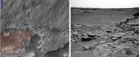
A nice sequence of HazCam images on sol 722 show the contact science placing the Dust Removal Tool and the pre-drill load test.
However, a http://mars.jpl.nasa.gov/msl-raw-images/msss/00722/mhli/0722MH0001970010204403C00_DXXX.jpgimage acquired after the load test suggests that they may have found a soft area (gap between the outcrop slabs) with the RH drill support post. The other post appears to have been a direct hit on one of the raised whitish material/ mineral?.
Posted by: climber Aug 18 2014, 01:26 PM
Interesting to see the vehicule going "up" when the arm hit the ground then "down" when it leaves...
Posted by: neo56 Aug 18 2014, 09:29 PM
Rocks on the southern wall of the entrance of Hidden Valley with MC100 on sol 721:
https://flic.kr/p/ovHTdj
Posted by: anticitizen2 Aug 18 2014, 09:55 PM
http://gfycat.com/IdealNeatFishingcat with multiple 'pushups'
Posted by: algorithm Aug 19 2014, 12:14 PM
It looks like the brush has seen better days.

|
Posted by: Gerald Aug 19 2014, 01:04 PM
http://mars.jpl.nasa.gov/msl-raw-images/msss/00291/mcam/0291MR1232000000E1_DXXX.jpg is an (almost) according Sol 291 image from a little different perspective, for comparison.
On Sol 291 the brush looked smoother, but it's not quite easy to pin down detailed changes, due to the change of perspective.
Posted by: jvandriel Aug 19 2014, 02:16 PM
but still working.
Jan van Driel

|
Posted by: anticitizen2 Aug 19 2014, 02:23 PM
More Sol 720 photometry - from the Mastcam now
http://i.imgur.com/XQyjUz1.gif
Sequences of 5 images, a bit over an hour apart:
- http://i.imgur.com/RB2EWFG.gif
- http://i.imgur.com/tSEKDON.gif
Pairs of images, about 4.5 hours apart: [order corrected]
- Mastcam Left #1 http://i.imgur.com/xKFHnB1.gif
- Mastcam Right #1 http://i.imgur.com/T4jsfqQ.gif
- Mastcam Left #2 http://i.imgur.com/hQx4DWp.gif
- Mastcam Right #2 http://i.imgur.com/Mxr1eZV.gif
Posted by: eoincampbell Aug 19 2014, 04:57 PM
Is the curious clump of slightly elongated bristles on one of the brushes unexpected... or a design feature...?
Posted by: Gerald Aug 19 2014, 05:30 PM
It led to reduced usage of the DRT for some time, to assess the relevance.
Posted by: Don1 Aug 20 2014, 08:08 AM
Bonanza King. Interesting name. The Bonanza kings were the men who gained control of Nevada's Comstock lode in the 19th century. The Comstock mines were some of the richest mines found in the 19th century California gold rush, yielding enough wealth to pay for the building of San Francisco.
It seems like somebody at JPL is feeling optimistic. I wonder why? Does Chemcam see an interesting compostion, maybe a carbonate or a sulfate? They are saying they think that Bonanza King is one of the base layers of Mt Sharp, but the pictures of the brushed rock don't look all that different from the stuff we have been driving over for months.
Posted by: serpens Aug 20 2014, 08:45 AM
I wouldn't read too much into the name. They seem to be in a California/Nevada naming zone and Bonanza King possibly is named after the Death Valley formation. But this seems to be pretty fine grained sandstone and to justify a drilling there could be something more compelling than calcium sulphate. Perhaps the devil is in the detail, or more specifically the cement. Clay perhaps.
Posted by: Gerald Aug 20 2014, 09:56 AM
http://mars.jpl.nasa.gov/msl-raw-images/proj/msl/redops/ods/surface/sol/00724/opgs/edr/fcam/FRB_461769013EDR_F0401378FHAZ00325M_.JPG shows contact of the drill with the ground, with load (compare it to http://mars.jpl.nasa.gov/msl-raw-images/proj/msl/redops/ods/surface/sol/00724/opgs/edr/fcam/FRB_461766525EDR_F0401378FHAZ00202M_.JPG without load), no actual drilling yet.
Posted by: Gerald Aug 20 2014, 11:13 AM
First images of drilling the mini drill hole are available now: Compare http://mars.jpl.nasa.gov/msl-raw-images/proj/msl/redops/ods/surface/sol/00724/opgs/edr/fcam/FRB_461767806EDR_S0401378FHAZ00214M_.JPG (before) with http://mars.jpl.nasa.gov/msl-raw-images/proj/msl/redops/ods/surface/sol/00724/opgs/edr/fcam/FRB_461768168EDR_S0401378FHAZ00214M_.JPG (after):
Posted by: anticitizen2 Aug 20 2014, 01:50 PM
Here are all the Hazcam images from 724
http://i.imgur.com/4zF5cBj.gif
Some movement of the turret during the drilling
Posted by: centsworth_II Aug 20 2014, 07:06 PM
Posted by: Gerald Aug 21 2014, 11:27 AM
Comparing http://mars.jpl.nasa.gov/msl-raw-images/proj/msl/redops/ods/surface/sol/00725/opgs/edr/fcam/FRB_461847397EDR_F0401378FHAZ00325M_.JPG with http://mars.jpl.nasa.gov/msl-raw-images/proj/msl/redops/ods/surface/sol/00724/opgs/edr/fcam/FRB_461767533EDR_F0401378FHAZ00211M_.JPG doesn't show arm movement.
Maybe the drillbit got stuck by yestersols tilt of the plate.
(There are more drillbits, if this can't be resolved easily.)
Edit: The plate seems to have been fractured under the right pin:
Posted by: anticitizen2 Aug 21 2014, 02:26 PM
Some pebbles rolled downhill, and it looks like some 'sinkholes' opened up
http://i.imgur.com/mNWnAb7.gif - http://i.imgur.com/MAiwPy8.gif
Posted by: centsworth_II Aug 21 2014, 05:53 PM
Posted by: Ant103 Aug 21 2014, 08:08 PM
A postcard from Sol 720, Mastcam100
http://www.db-prods.net/blog/2014/08/21/distant-hills-sol-720-postcard/
Posted by: Gerald Aug 21 2014, 08:22 PM
Perfect work, Damia!
I wasn't quite sure about this; but it would probably be good news for the drill bit to get free, by some percussing, if necessary.
Posted by: algorithm Aug 21 2014, 08:38 PM
Does the drill also rotate in a reverse direction?
Posted by: Gerald Aug 21 2014, 08:53 PM
The drill resembles more a chisel without a thread. That's not an answer to your question. But it reduces the relevance of the direction of the rotation.
Posted by: Ant103 Aug 21 2014, 09:27 PM
A comparison of the drilling site. Before and during (respectively Sol 722 & 724)
|
Posted by: djellison Aug 21 2014, 09:56 PM
Yup - there's threading -but only inside the collar mechanism that pulls dust up into the CHIMRA mechanism
http://www.nasa.gov/images/content/727102main_pia16727-43_946-710.jpg
http://bestdrillingbits.com/wp-content/uploads/2013/08/dril_bit_diagram.jpg
Infact - the drill doesn't really spin round like a drill at all. It's more a percussive chisel that rotates only at about 60rpm...not the hundreds and hundreds of a typical 'drill'
https://www.youtube.com/watch?v=nq9xUr4T7E8
Posted by: centsworth_II Aug 21 2014, 09:58 PM
Posted by: serpens Aug 21 2014, 11:48 PM
I think you are right. In fact I would posit that the vibration of drilling resulted in the settling of dust fill in pre existing cracks around the plate perimeter and there was little if any plate displacement.
Posted by: Phil Stooke Aug 22 2014, 01:59 AM
If you overlay the pre- and post- preload test Mastcam images you will find there was some movement even then.
PS - Damia, that's a really beautiful view in your latest image.
Phil
Posted by: Gerald Aug 22 2014, 09:24 AM
From the tailings I'd guess, http://mars.jpl.nasa.gov/msl-raw-images/msss/00726/mhli/0726MH0004200010204423C00_DXXX.jpg should show the mini-drill"hole".
The "rock" seems to be very very soft. The drillbit got clear easily.
Edit: The rock looks like a loosely cemented sandstone with a size of about 150 - 200 μm for the larger grains.
Here a 2x magnified and sharpened crop of http://mars.jpl.nasa.gov/msl/multimedia/raw/?rawid=0726MH0004210010204431C00_DXXX&s=726, showing some of the tailings, scale calculated from the motor count:
Posted by: jvandriel Aug 22 2014, 09:27 AM
2 Panoramas taken on Sol 720 with the Mastcam R camera,
Images Debayered, stitched and sharpened.
Jan van Driel

|
Posted by: jvandriel Aug 22 2014, 09:30 AM
and the other one.
Jan van Driel

|
Posted by: SFJCody Aug 22 2014, 11:27 AM
Are these panoramas to seek out the most benign terrain for driving?
Posted by: fredk Aug 22 2014, 02:17 PM
Beautiful debayering job, Ant. Could you let us in on your secrets - is that using ImageJ or Gimp?
Posted by: Ant103 Aug 22 2014, 02:58 PM
Thank you Fred and everyone
Fred, before I was using ImageJ, but I found that G'MIC Gimp plugin Bayer reconstruction worked better (less artifacts from jpeg degradations of the Bayer matrix).
Posted by: Bubbinski Aug 22 2014, 02:59 PM
I see the sol 726 raw images have come in. The drill hole looks elongated, is it because the rock is so soft?
Posted by: elakdawalla Aug 22 2014, 03:02 PM
When they start drilling, the first thing they do is to tap a little hole in the target without much rotation of the drill bit. It looks like they got as far as tapping the hole but quit before getting to the part where they rotate the drill bit.
Posted by: Bubbinski Aug 22 2014, 03:50 PM
Thanks Emily. On the MAHLI images there are a lot of grayish "tailings", do they have the sample they need or are they going to try drilling elsewhere nearby?
Posted by: Gerald Aug 22 2014, 04:34 PM
To get a sample, they need to drill deeper than 2 cm, usually about 6 cm.
This has been less than 2 cm, and for test purposes, hence they don't have the sample yet.
Based on this test drill, the team will decide, whether the rock is valid for sample acquisition.
Might be, they'll try another test drill first.
Posted by: elakdawalla Aug 22 2014, 05:29 PM
Note that http://www.midnightplanets.com/web/MSL/sol/00725.html have the turret in the middle of the field of view with the drill still on the target. They almost certainly did not intend to do multispectral imaging of the turret; which means they didn't expect the turret to be there, which implies that the sequence faulted before reaching completion. I don't have any insight into what they plan to do next.
Posted by: algorithm Aug 22 2014, 06:11 PM
Infact - the drill doesn't really spin round like a drill at all. It's more a percussive chisel that rotates only at about 60rpm...not the hundreds and hundreds of a typical 'drill'
I was going to suggest percussion with slight lift, spin without percussion, push down, lift up,,, and then, I remembered....IT'S ON ANOTHER PLANET,,,,,,DOH!!!
Posted by: anticitizen2 Aug 22 2014, 08:18 PM
Navcam before/after
http://i.imgur.com/6Sd4sp9.gif
Posted by: wildespace Aug 22 2014, 08:48 PM
The rock moved. http://www.jpl.nasa.gov/news/news.php?release=2014-286
3D anaglyph of the unsuccessful drill site, created using a pair of MAHLI images http://mars.nasa.gov/msl/multimedia/raw/?rawid=0726MH0004200030204425C00_DXXX&s=726 and http://mars.nasa.gov/msl/multimedia/raw/?rawid=0726MH0004200010204427C00_DXXX&s=726

|
http://www.pictureshack.us/images/23849_0726MH.jpg
Posted by: serpens Aug 23 2014, 02:13 AM
Was that an isolated, thin sandstone sheet or was this a product of fissility, which could possibly indicate that Bonanza King is a shale?
Posted by: Gerald Aug 23 2014, 09:35 AM
When looking at http://mars.jpl.nasa.gov/msl-raw-images/msss/00726/mhli/0726MH0004240010204417C00_DXXX.jpg, fractures and microfractures due to physical weathering or impact shocks, together with poor embedding, could well explain the behaviour, such that deriving shale probably wouldn't be conclusive.
Posted by: anticitizen2 Aug 23 2014, 03:29 PM
Mastcam before/after. Looks vicious in color.
http://imgur.com/oGkvoVR.gif
http://i.imgur.com/PXJqBnz.gif
Posted by: fredk Aug 23 2014, 06:55 PM
One of the 727 chemcam nightsky pointing accuracy observations:

|
The fuzziness is just due to the camera PSF, I assume. I don't know where they were pointing at.
Posted by: Reed Aug 23 2014, 11:18 PM
Based on the pointing info from Joe Knapps site and some fiddling in stellarium, I think the one at 06:44:56 P.M. LMST is Spica, and the one at 06:56:37 P.M. LMST is Regulus
Posted by: Gerald Aug 25 2014, 09:54 AM
There seems to have been a drive of a little less than 1.5 h on Sol 729, derived from the timestamps of http://mars.jpl.nasa.gov/msl-raw-images/proj/msl/redops/ods/surface/sol/00729/opgs/edr/ncam/NRB_462215159EDR_T0401840TRAV00271M_.JPG and http://mars.jpl.nasa.gov/msl-raw-images/proj/msl/redops/ods/surface/sol/00729/opgs/edr/ncam/NRB_462210003EDR_T0401378TRAV00271M_.JPG (5159 - 0003 = 5156 [s]).
Posted by: jvandriel Aug 25 2014, 10:01 AM
Another nice view taken on Sol 727 with the Pancam R camera.
Jan van Driel

|
Posted by: jmknapp Aug 25 2014, 10:03 AM
http://curiosityrover.com/tracking/drivetrack.php?drivenum=232
Posted by: anticitizen2 Aug 25 2014, 01:55 PM
http://imgur.com/a/0Y27j#0 overlooking the valley
http://imgur.com/a/chg82#0
Posted by: Phil Stooke Aug 25 2014, 03:50 PM
This is a quick circular view to show our location, looking into the depression which - I presume - we are about to cross.
Phil

|
Posted by: jvandriel Aug 25 2014, 07:11 PM
and here is the Navcam Panoramic view on Sol 729.
Jan van Driel

|
Posted by: atomoid Aug 25 2014, 11:32 PM
crosseye of some http://www.midnightplanets.com/web/MSL/image/00728/0728MR0031180010402945E01_DXXX.html wrecking yard features

|
Posted by: jvandriel Aug 26 2014, 02:49 PM
The complete Navcam view on Sol 729.
Jan van Driel
|
|
Posted by: anticitizen2 Aug 26 2014, 03:04 PM
http://gfycat.com/WiltedCreativeHairstreakbutterfly http://gfycat.com/WiltedCreativeHairstreakbutterfly
76 frames lasting a little over a minute. Right click to show controls for the HTML5 video.
http://gfycat.com/UltimateCanineGyrfalcon
Posted by: jvandriel Aug 26 2014, 08:18 PM
ChemCam panorama taken on Sol 730.
Jan van Driel

|
Posted by: Phil Stooke Aug 27 2014, 02:07 PM
This is the circular view after the sol 731 drive, about 10 m SW. Only looking backwards so far.
Phil

|
Posted by: jmknapp Aug 28 2014, 12:20 AM
The speed plot of the recent drive (16m per the telemetry):
http://curiosityrover.com/tracking/speedplot.php?drivenum=233
Well, that's different! Crawling along at ~0.5cm/s for an hour--so unlike the usual pulsed mode with 3 cm/s top speed.
Posted by: xflare Aug 28 2014, 09:00 AM
I wonder if it would have made any difference if the orientation of the dunes in the valley had been different and Curiosity had been able to drive along the ridges like Opportunity did for most of it's journey south, rather than across them.
Posted by: jmknapp Aug 28 2014, 01:05 PM
Looks like that was preliminary data. The latest SPICE update shows a different http://curiosityrover.com/tracking/drivetrack.php?drivenum=233 and http://curiosityrover.com/tracking/speedplot.php?drivenum=233 profile, more of a 21m dogleg.
Posted by: Gerald Aug 28 2014, 02:49 PM
Sol 730 MARDI, enhanced, fisheye-corrected 93°:
http://imgur.com/Fryw2lD
Posted by: Gerald Aug 28 2014, 03:33 PM
This looks a bit like a Martian testbed to study sand-wheel interaction: http://mars.jpl.nasa.gov/msl-raw-images/proj/msl/redops/ods/surface/sol/00731/opgs/edr/ncam/NLB_462392403EDR_F0402040NCAM00269M_.JPG.
I'm curious, whether they'll first do some test driving here, or drive directly to Emigrant Pass or Amargosa Valley.
Posted by: Floyd Aug 28 2014, 04:01 PM
That is one big dark rock past the dunes. Shows up nicely on the route map as well. http://mars.jpl.nasa.gov/msl-raw-images/proj/msl/redops/ods/surface/sol/00731/opgs/edr/ncam/NLB_462392403EDR_F0402040NCAM00269M_.JPG.
Posted by: Bubbinski Aug 29 2014, 12:53 PM
Raw images for sol 733 are in, it looks like Curiosity drove away from Mt. Sharp and more northward?
Posted by: Phil Stooke Aug 29 2014, 01:25 PM
http://www.midnightplanets.com/web/MSL/image/00733/RLB_462572886EDR_F0410000RHAZ00313M_.html
Bubbinski - not north - we went west. Mt Sharp extends from east through south to southwest on the horizon, we are driving away from the east end of it. This drive went through the crater with drifts on its northern wall, and up onto the western side of it. We are just southwest of the big rock referred to recently by Floyd.
Rough circular view:

|
Phil
Posted by: elakdawalla Aug 29 2014, 06:54 PM
Split the conversation about night driving to http://www.unmannedspaceflight.com/index.php?showtopic=7880&hl=.
Posted by: Gerald Aug 29 2014, 08:19 PM
Well anticipated:
|
(crop of http://mars.jpl.nasa.gov/msl-raw-images/proj/msl/redops/ods/surface/sol/00733/opgs/edr/ncam/NRB_462573051EDR_F0410000NCAM00270M_.JPG)
Posted by: Phil Stooke Aug 31 2014, 03:14 PM
A half-pan shows our surroundings on sol 735.
Phil

|
Posted by: anticitizen2 Aug 31 2014, 04:38 PM
http://imgur.com/a/hZEpp#0
http://imgur.com/a/Fr3kv#0 version reminds me of a skate park
Posted by: walfy Sep 3 2014, 06:36 AM
More wonderfully strange rock formations, from recent sol. Here are just a few:

|

|

|
Posted by: Astro0 Sep 3 2014, 09:02 AM
Moved a series of posts on image processing to determine the traversibility of terrain to the: http://www.unmannedspaceflight.com/index.php?showtopic=7418 thread.
Posted by: Phil Stooke Sep 3 2014, 03:18 PM
A quick circular view of the area on sol 738. The path ahead is probably down the notch west of us (8:00 position) and onto a smoother surface.
EDIT: I started out by saying here that the white spots visible in images were closer to us than the hills we are aiming for, but I was wrong. Goofiness retracted!
Phil

|
Posted by: anticitizen2 Sep 3 2014, 04:09 PM
According to http://www.unmannedspaceflight.com/index.php?showtopic=7868&view=findpost&p=212125 from Ashwin's presentation - Pahrump is the white splotch visible across the valley floor.

|
http://imgur.com/a/uKuHr#0 - and the http://imgur.com/a/6ZOIU#0
Drive animations from last week
runs about 2:30 - right click to show controls and enable rewinding.http://gfycat.com/WeeAdolescentIndianhare
http://gfycat.com/SereneHighAmericancurl
Posted by: Phil Stooke Sep 3 2014, 04:16 PM
EDIT: This post originally restated what I posted above, but when doing a higher resolution reprojection of the images I realized I was completely wrong! Yes indeed, those bright spots are the hills we are aiming for. Sorry about that!
Phil
Posted by: neo56 Sep 3 2014, 04:57 PM
Panorama taken on sol 735 with MC34:
https://flic.kr/p/oLskQj
Posted by: fredk Sep 3 2014, 05:26 PM
It's rare to see anything in solar filter images apart from the sun, but in this sol 732 image the sun is so low in the western sky that the sky:sun brightness ratio is unusually high and we can just see the horizon:

|
Processing included background subtraction, Gaussian blur, and contrast tweak.
Posted by: fredk Sep 3 2014, 05:55 PM
Good eye! I had to make an anaglyph before I'd believe this really was a balancing rock:

|
Cross-eyed:

|
This is definitely one of the most impressive formations we've seen.

Posted by: serpens Sep 3 2014, 11:28 PM
The bent sheet beneath the overhang is as impressive as the balancing rock. It seems to have "exfoliated" from the balancing rock.
Posted by: jmknapp Sep 4 2014, 12:30 AM
Is it for sure balancing, or might it all be one piece?
Posted by: atomoid Sep 4 2014, 12:40 AM
indeed! there is a continual cavalcade of curious configurations from sol735. both in parallel format.
-- At left a yet-to-be-exfoliated sheet appears an upside-down case of the other one, perhaps a http://www.midnightplanets.com/web/MSL/image/00735/0735MR0031500030403078E01_DXXX.html hollowed out by ground-level sandblast..
-- At right there is a equilateral trifecta of fascinating specimens at lower half, one like a backwards 'E', a flat hand, and a 'http://www.metroactive.com/metro/10.21.09/arts-0942.html' at bottom which does appear to be a real hole when viewed in the less lossy http://www.midnightplanets.com/web/MSL/image/00735/0735MR0031500040403079E01_DXXX.html, as you can see through that hole to the rock behind it.
-- Finally, back to sol731 nice plate collection at bottom, stereogram suffered by noisy M-34s, much better seen in http://www.midnightplanets.com/web/MSL/image/00731/0731MR0031320060402993E01_DXXX.html

|

|

|
Posted by: neo56 Sep 4 2014, 09:45 AM
Panoramas of the sand ripples field along which Curiosity roved last week:
- with MC34 on sol 731:
https://flic.kr/p/p4xFW4
- with MC100 on sol 733:
https://flic.kr/p/oLx6id
Posted by: neo56 Sep 4 2014, 10:06 AM
Nice blue sunset on sol 734:
https://flic.kr/p/oM5fBi
Posted by: Phil Stooke Sep 4 2014, 04:45 PM
A circular half-pan shows us closer to the edge of the outcrop on sol 739.
Phil
|
Posted by: algorithm Sep 4 2014, 08:00 PM
The Sol 739 Navcam Pan as an anaglyph
|
It looks like kinder terrain may lie ahead (at least in terms of the rock count)
Posted by: jmknapp Sep 5 2014, 12:29 AM
But it's not exactly a red carpet at the entrance.
|
Posted by: brellis Sep 5 2014, 05:15 AM
"not exactly a red carpet at the entrance" - tempted me to wonder how clear the threat is from what is visible in the image on the right in jmknapp's Post #229. Rereading Emily's (wonderful, as usual!) http://www.planetary.org/blogs/emily-lakdawalla/2014/08190630-curiosity-wheel-damage.html:
On hazardous terrain, performing shorter drives allows them to avoid many potentially wheel-damaging rocks.
I ask the experts: is there a safe-ish way through this entrance?
Posted by: Gerald Sep 5 2014, 12:22 PM
Driving forward over well-embedded hard and pointed rocks causes most of the damage.
By minimizing this kind of settings, the risk of damage can be managed.
An approach to minimize fatigue caused by the overall roughness could be minimizing the integral of hardness times roughness over the path of the drive.
Since the drive through this rough terrain is rather short, and there aren't too many embedded pointed rocks, it's reasonable to take this path. The terrain in the valley is much smoother, and making long detours would probably sum up to more damage, and waste more time than necessary.
The expected science return of the Pahrump Hills is certainly worth to take some risk.
http://astrogeology.usgs.gov/news/astrogeology/sol-740-update-on-curiosity-from-msl-scientist-lauren-edgar-approaching-amargosa-valley.
That's at least my way to duplicate the decision, after quite some pondering the last few days, whether there may be a better path. This has been one of the first of just a few alternatives.
Posted by: elakdawalla Sep 5 2014, 02:31 PM
I'm not too sure what the process of avoiding hazardous rocks looks like. One of the surprising things I learned, writing that article, is that something that looks like flagstones is far superior to wheel-chewing terrain. They have an 8-kilometer lifetime over the bad terrain, but 30-50 kilometer lifetime over flagstones. As long as bad rocks are far enough apart, they can really mitigate the threat of damage.
Posted by: charborob Sep 5 2014, 05:50 PM
Sol 739 mastcam view of Owens Valley:
|
|
Posted by: anticitizen2 Sep 5 2014, 06:10 PM
What a fantastic view!
http://i.imgur.com/mADKVR4.gif
Anaglyph albums from yesterday and today:
http://imgur.com/a/9eScE - http://imgur.com/a/0NUEQ
http://imgur.com/a/oSuiJ#0 - http://imgur.com/a/9kI4F#0
Posted by: algorithm Sep 5 2014, 07:28 PM
It's certainly rough and bumpy but not full of sharp damaging rocks though.
The odd tip hazard!?
A bit of wheel slip here and there!?
The descent seems ok
The question is, who wants to rule the sand pit?
Posted by: Floyd Sep 5 2014, 10:24 PM
It is easy to loose track of the map showing where we are trying to go. Here is Joe's map from an earlier thread: http://www.unmannedspaceflight.com/index.php?act=attach&type=post&id=33244
Posted by: serpens Sep 5 2014, 10:24 PM
Mmmm, is that total or estimated remaining?
Posted by: Gerald Sep 5 2014, 11:02 PM
Only "total" makes really sense, otherwise it would need to be updated all the time. So subtract a few hundred meters for the remaining distance.
But it has been a conservative estimate, and it will probably become obsolete with the software update in about four months.
Since they are already using a work-around, the number has become a theoretical value for a way of driving which is avoided.
Posted by: neo56 Sep 6 2014, 06:50 AM
My take on the panorama of Amargosa Valley on sol 739:
https://flic.kr/p/oNAaZD
Posted by: Gerald Sep 6 2014, 01:05 PM
Sol 740 "http://astrogeology.usgs.gov/news/astrogeology/sol-740-update-on-curiosity-from-msl-scientist-lauren-edgar-approaching-amargosa-valley", processed versions roughly stitched:
http://imgur.com/dxKsFOv
Posted by: anticitizen2 Sep 6 2014, 03:43 PM
MARDI drive thumbnails 
Posted by: neo56 Sep 6 2014, 04:28 PM
Nice video antcitizen2 !
Here is the panorama taken on sol 740 with MC34:
https://flic.kr/p/oNWx5y
A mosaic of MC34 pictures showing fractured rocks:
https://flic.kr/p/oNXJFM
And a pansharpening between the RMI mosaic of Pahrump Hills and a MC34 picture:
https://flic.kr/p/oNZmoQ
Posted by: Dig Sep 6 2014, 06:15 PM
Right Navcam. Sol 740 complete.
http://bit.ly/ZcMi0x
Posted by: nprev Sep 6 2014, 10:48 PM
I've been trying very hard not to make frivolous comments, but all you guys...good grief...just ridiculously beautiful work!!!!!
Calling many of you 'amateurs' is sometimes a bit like calling Van Gogh 'a decent one-eared painter'.  Thanks!
Posted by: Ron Hobbs Sep 6 2014, 11:12 PM
What he said!!
Posted by: serpens Sep 6 2014, 11:15 PM
Seconded, and I have to tip me hat to Steve Squires for championing the cause of total and immediate release of raw image data, creating the environment that let such expertise to flourish for the MER and subsequently MSL.
Posted by: Phil Stooke Sep 7 2014, 12:43 AM
Here's a circular view of Dig's beautiful panorama from the bottom of that notch in the scarp. The valley floor looks a lot better than Hidden Valley for driving.
Phil

|
Posted by: RoverDriver Sep 7 2014, 12:51 AM
Calling many of you 'amateurs' is sometimes a bit like calling Van Gogh 'a decent one-eared painter'.
Thanks!Actually that's *because* they are amateurs (which has its roots in lovers) they do such a fine job. I often find myself admiring Mars on these mosaics rather than the official I get at work.
Paolo
Posted by: Gerald Sep 7 2014, 01:41 AM
I'm always fascinated of these seamless, properly flatfielded, brightness- and color-adjusted stitches, which I'm rarely patient enough to accomplish...
...Some much more humble processing:
We'll likely see close-up MAHLIs of a nearby target, soon.
In the meanwhile here the http://mars.jpl.nasa.gov/msl-raw-images/msss/00739/mrdi/0739MD0003130000102463E01_DXXX.jpg, cleaned of most of the "fog":
http://imgur.com/u6BeyVT
Posted by: jvandriel Sep 7 2014, 12:15 PM
3 MAHLI images, Sol 738-740 stitched together.
Jan van Driel

|
Posted by: scalbers Sep 7 2014, 07:09 PM
Here is a recent Applied Optics paper that includes the factors helping to produce the blue glow around the sun on Mars. Interesting to see the phase functions plotted in Figure 9, relevant both to near the sun and other parts of the sky.
http://www.opticsinfobase.org/ao/abstract.cfm?uri=ao-53-9-1808
Posted by: anticitizen2 Sep 8 2014, 04:14 PM
http://gfycat.com/GracefulColdArieltoucan - http://gfycat.com/CoarseAmusedChital
About 1:40 in length, right click to show controls. I try to add pauses around major turns.
http://i.imgur.com/AJ82gXC.gif, there is much more to look at than the 738 drive
Posted by: Gerald Sep 8 2014, 04:51 PM
On Sol 743 there has been a drive of almost three hours, with some mid-drive imaging; http://astrogeology.usgs.gov/news/astrogeology/sol-741-743-update-on-curiosity-from-usgs-scientist-ken-herkenhoff-busy-weekend.
http://mars.jpl.nasa.gov/msl-raw-images/proj/msl/redops/ods/surface/sol/00743/opgs/edr/ncam/NRB_463456800EDR_F0411330NCAM00276M_.JPG we're quite a bit further to the south, towards Pahrump Hills.
Posted by: fredk Sep 8 2014, 05:06 PM
Speckled rocks exposed after a drive:
http://mars.jpl.nasa.gov/msl-raw-images/msss/00739/mcam/0739ML0031640930205431E01_DXXX.jpg
Posted by: elakdawalla Sep 8 2014, 05:08 PM
Wow!! What is that? More of that plag-lath-rich stuff? If so, I'm surprised it breaks so easily.
Posted by: nprev Sep 8 2014, 05:21 PM
Great Scott!!! It almost looks like a carbonaceous chondrite, albeit with BIG chondrules!
Posted by: SFJCody Sep 8 2014, 05:22 PM
Great to see the true colours of the rocks under the ubiquitous Martian dust. I sometimes think it would be nice to have a ruggedized Roomba precede the rover for that purpose.
Posted by: jvandriel Sep 8 2014, 05:49 PM
The Left Navcam view on Sol 743.
Jan van Driel

|
Posted by: jmknapp Sep 8 2014, 07:17 PM
Back to ~100m drives--that's the spirit!
http://curiosityrover.com/tracking/drivetrack.php?drivenum=239
Posted by: Phil Stooke Sep 8 2014, 07:34 PM
Ack - beat me to it, Joe! Here's a circular pan of our new location - the rocky outcrops all around give a very good fix on location.
Phil

|
Posted by: neo56 Sep 8 2014, 07:37 PM
The chondrules-rich rock noticed by fredk reminds me a http://www.midnightplanets.com/web/MSL/image/00739/CR0_463091822PRC_F0410592CCAM02739L1.html.
Posted by: Gerald Sep 8 2014, 08:45 PM
http://en.wikipedia.org/wiki/Efflorescence/http://en.wikipedia.org/wiki/Evaporite kind of http://en.wikipedia.org/wiki/Precipitation_(chemistry)?
The specks look a bit like being constraint to the surface of the rock.
http://en.wikipedia.org/wiki/Plagioclase would probably extend to the interior.
Might be a way to get specks consistent with a sedimentary (weak and brittle in this case) rock.
On the other hand, the clusts(?) in the ChemCam image look rather brecciated. So a sedimentary breccia might be another idea.
Posted by: James Sorenson Sep 9 2014, 07:35 AM
My go at the Sol-739 Mastcam 360 Panorama.
https://flic.kr/p/p6XHpf
And on Gigapan
http://www.gigapan.com/gigapans/162290
Posted by: Dig Sep 9 2014, 10:23 AM
Sol 743 Right Navcam complete panorama
http://bit.ly/1qbDfZk
and Little Planet projection

|
Posted by: serpens Sep 9 2014, 10:47 AM
The speckles are interesting, but these white bits more so.

|
Posted by: Phil Stooke Sep 9 2014, 02:10 PM
My circular version of Dig's beautiful Navcam panorama:

|
Phil
Posted by: jvandriel Sep 9 2014, 03:15 PM
The Mastcam R view on Sol 740.
Jan van Driel
|
|
Posted by: fredk Sep 9 2014, 05:20 PM
Those white bits appear to be in the wheel tracks - check out http://mars.jpl.nasa.gov/msl-raw-images/proj/msl/redops/ods/surface/sol/00739/opgs/edr/ncam/NLB_463107836EDR_F0410748NCAM07753M_.JPG for a wider perspective. We often see bright glints after the wheels scrape rock.
Posted by: Mercure Sep 9 2014, 08:22 PM
That would be a Barsoomba...
Posted by: nprev Sep 10 2014, 12:09 AM
...aaand, Mecure is banned for life.
I wonder if there are any places like 'choke-point' entries to gullies or canyons where the prevailing winds tend to minimize dust accumulation. There are so many tantalizing hints of almost Earthlike diversity in rock appearance if only the dust wasn't there.
Posted by: xflare Sep 10 2014, 08:11 AM
http://www.jpl.nasa.gov/news/news.php?release=2014-305
NASA will host a telecon at 10 a.m. PDT (1 p.m. EDT) Thursday, Sept. 11, to discuss mission status and the future science campaign for the Mars rover Curiosity mission.
Participants in the teleconference will be:
-- Jim Green, director, Planetary Science Division, NASA Headquarters, Washington
-- John Grotzinger, Curiosity project scientist, California Institute of Technology, Pasadena
-- Kathryn Stack, Curiosity Rover mission scientist, NASA's Jet Propulsion Laboratory, Pasadena. California
Posted by: jmknapp Sep 10 2014, 10:58 AM
Great! It's been a long time since the last telecon, right? Maybe they'll clarify what the coming driving strategy is per the wheel/sand issues and also the extended mission review board. As I understand the report, the main disagreement is not over the driving/science mix so far, but the tradeoff once they get to the foothills and traverse though the hematite, clay and sulfate areas which are more on point to the science goals. It would be good to see clarification on that.
EDIT:
Some of the latest NAVCAM images are at an odd angle, no?
http://mars.jpl.nasa.gov/msl-raw-images/proj/msl/redops/ods/surface/sol/00744/opgs/edr/ncam/NLB_463551897EDR_F0411570NCAM00277M_.JPG
Posted by: Gerald Sep 10 2014, 01:02 PM
Seems there has taken place a drive onto a slope after wheel imaging: http://mars.jpl.nasa.gov/msl-raw-images/proj/msl/redops/ods/surface/sol/00744/opgs/edr/fcam/FRB_463551663EDR_F0411570FHAZ00302M_.JPG.
Posted by: PaulH51 Sep 10 2014, 01:26 PM
Possibly a new tactic to pass the short sandy region ahead? Providing the angle is not too extreme (we don't have Joe's drive data yet), maybe keeping one set of wheels on the outcrop and the others on the sand will negate / reduce issues with wheel slip seen in hidden valley?
Posted by: Phil Stooke Sep 10 2014, 02:02 PM
Here's our current position in a (semi)circular view - from this it's easy to find the spot on the map.
Phil

|
Posted by: jvandriel Sep 10 2014, 02:05 PM
Here is the Navcam L view on Sol 744.
Jan van Driel

|
Posted by: SpaceListener Sep 10 2014, 04:41 PM
Well, there is difference of risk to rover on dusty or sandy surface. For a dust soil, the risk is its unknown depth of firm soil and also below of dusty soil may have hidden stones! The risk of sandy surface is about how loose is it. I don't think that by that zone has high amount of dust but of few centimenters height.
Posted by: jmknapp Sep 10 2014, 05:52 PM
Whoa--some stunt driving. I was thinking that the front wheel at the bottom of this image might actually be off the surface:
http://mars.jpl.nasa.gov/msl-raw-images/proj/msl/redops/ods/surface/sol/00744/opgs/edr/ncam/NLB_463552542EDR_F0411570NCAM00351M_.JPG
The SPICE data should be updated in a couple hours (~1pm pacific). It usually comes in around 6pm Mars time. But Phil has the location in the http://www.unmannedspaceflight.com/index.php?showtopic=7442&view=findpost&p=212834, a little in the rough.
Posted by: anticitizen2 Sep 10 2014, 07:15 PM
Sol 743 anaglyph albums during and after the first drive across Owens:
http://imgur.com/a/1lyYP#0
http://imgur.com/a/Fu5Dk#0 -- http://imgur.com/a/He7pw#0
Looking forward to the 744 ones, but no time now
Posted by: jmknapp Sep 11 2014, 04:48 PM
The visuals for the telecon are up:
http://www.nasa.gov/mission_pages/msl/telecon/index.html#.VBHSDvlr7TY
Lead-in music is "Ain't no mountain high enough, ain't no valley low enough... to keep me from gettin'to you babe."
EDIT:
The gist of it is that this is what John Grotzinger calls the "EDL moment" of the "go-to" phase of the mission. I.e., they are changing the planned traverse to Murray Buttes and are cutting in to the Mount Sharp boundary (aka the Murray formation) now (or very soon). The new route is shown in this image:
http://www.nasa.gov/jpl/msl/pia18475
The boundary of Mt. Sharp is taken to be the white dotted line in the image below, so it can be seen that Pahrump Hills, the next drill target, is across the goal line:
http://www.nasa.gov/jpl/msl/pia18474
They should be there in a week or two and they have a clear path. The new route means that the science phase begins sooner and this just happens, ahem, to align with review board goals. The new route is about 1 km shorter to the point where the old and new routes converge.
The Pahrump hills formation will likely have high-silicon minerals, with a significant height of exposed layers, that may well be favorable to organic preservation if indeed there was primary carbon enrichment in the area in the first place. From there they will drive by some dunes that they will study even though not a major science goal of this mission, and then push on to the hematite formation.
Posted by: jvandriel Sep 11 2014, 06:32 PM
The complete Navcam L panoramic view taken on Sol 744.
Jan van Driel

|
Posted by: Phil Stooke Sep 11 2014, 08:16 PM
A very quick sol 746 circular view:

|
Phil
Posted by: jvandriel Sep 12 2014, 08:59 AM
Here is the complete Navcam L view on Sol 746.
Jan van Driel
|
|
Posted by: MahFL Sep 12 2014, 10:16 AM
In the link below it says the route is 100m shorter, it's seems a lot more than 100m to me.
http://www.nasa.gov/jpl/msl/pia18475/
Posted by: PaulH51 Sep 12 2014, 10:25 AM
Agreed, I roughly plotted the two paths into Google Mars from the current location
Extended safe path = 4.75 kilometers
Next Steps path = 3.68 kilometers
So it appears to be a typo in the report and probably should have read ~1000m
Posted by: ngunn Sep 12 2014, 10:26 AM
They said 1 km in the presentation
Posted by: MahFL Sep 12 2014, 10:42 AM
Makes sense, unfortunately I missed the telecon, just catching up. Amazing topography ahead.
Posted by: belleraphon1 Sep 12 2014, 12:26 PM
Yesterday's telecon can be heard here..
Curiosity News Telecon 09/11/2014 reached the foothills of Mt. Sharp
http://www.ustream.tv/nasajpl#/recorded/52551576
visuals
http://www.nasa.gov/mission_pages/msl/telecon/index.html
Posted by: Gerald Sep 12 2014, 12:28 PM
Animated gif of 23 processed Sol 739 MARDI images, reduced 4x:
http://imgur.com/TZPWP2j
http://imgur.com/a/4gWVG#0.
Posted by: Phil Stooke Sep 12 2014, 02:08 PM
A couple of full-circle versions of Jan's recent panoramas.
Phil
744:

|
746:

|
Posted by: Gerald Sep 12 2014, 08:55 PM
A bit more than 2.5 hours driving on Sol 747: http://mars.jpl.nasa.gov/msl-raw-images/proj/msl/redops/ods/surface/sol/00747/opgs/edr/ncam/NRB_463813232EDR_F0420000NCAM06094M_.JPG.
About 60 m to the south?
Posted by: Phil Stooke Sep 12 2014, 09:01 PM
About 80 m! EDIT: I replaced my rough, partial panorama reprojection with one made from Jan's panorama in the next post - it's much better.
Phil

|
Posted by: jvandriel Sep 13 2014, 01:55 PM
and the complete Navcam L panoramic view taken on Sol 747.
Jan van Driel
|
|
Posted by: walfy Sep 13 2014, 11:09 PM
Wow, Pahrump Hills just a drive or two away now:
http://mars.jpl.nasa.gov/msl-raw-images/proj/msl/redops/ods/surface/sol/00748/opgs/edr/ncam/NRB_463898397EDR_F0420186NCAM00280M_.JPG
Should be interesting to see these bright new rocks up close. Say hello to our future home! At least for a few weeks.
Posted by: Gerald Sep 13 2014, 11:41 PM
Here a preliminary NRB stitch, Sol 748:
http://imgur.com/N8erLOy
Posted by: serpens Sep 14 2014, 12:14 AM
The Extended Mission Review Proposal is probably the best summary of the MSL progress and environment available. For those that missed it is available at:
http://mars.nasa.gov/files/msl/2014-MSL-extended-mission-plan.pdf
With regard to the new route it will be interesting to see if the change in sediment results in a more wheel friendly driving environment.
Posted by: neo56 Sep 14 2014, 11:10 AM
Daily MC34 panoramas:
Sol 743:
https://flic.kr/p/pcU3iV
Sol 744:
https://flic.kr/p/oVFikB
Sol 746:
https://flic.kr/p/oVF1Zv
Posted by: TheAnt Sep 14 2014, 11:54 AM
Thank you for the heads up Serpens.
Yes lets hope they find a path that is less mechanically demanding.
As a side note: I could read that they will be actively looking for recently exposed rocks in the search for organics.That's a good idea, even so the proposal also point out what will happen to any molecules over such long time spans. The remainder that might be left could leave us with a ambiguous signal to the origin.
Posted by: ngunn Sep 14 2014, 12:44 PM
Let's hope there's no methane at our immediate destination. Imagine the headlines . . .
Posted by: jmknapp Sep 14 2014, 04:46 PM
They mentioned in the recent telecon that the high levels of radiation on the surface would degrade any organic molecules pretty readily, hence the preference for relatively recent exposures.
EDIT: from the telecon (John Grotzinger answering a question by Leo Enright):
He goes to to say that for these three criteria they like "deeply dissected" formations such as Pahrump (dissected by the winds), i.e., let the wind do the "deep drilling" for you.
Powered by Invision Power Board (http://www.invisionboard.com)
© Invision Power Services (http://www.invisionpower.com)