Dawn's Survey Orbit at Ceres |

Dawn's Survey Orbit at Ceres |
 Jun 15 2015, 05:47 PM Jun 15 2015, 05:47 PM
Post
#1
|
|
 Senior Member  Group: Members Posts: 1729 Joined: 3-August 06 From: 43° 35' 53" N 1° 26' 35" E Member No.: 1004 |
daily Ceres picture from the survey orbit
http://dawn.jpl.nasa.gov/multimedia/images...tml?id=PIA19572 I started a new topic, as we are no longer in the first orbit phase |
 |
 
|
 |
|
Jun 15 2015, 06:21 PM
Post
#2
|
|
|
Newbie Group: Members Posts: 8 Joined: 20-April 15 Member No.: 7446 |
QUOTE (Paolo @ Jun 15 2015, 10:47 AM)  daily Ceres picture from the survey orbit http://dawn.jpl.nasa.gov/multimedia/images...tml?id=PIA19572 I started a new topic, as we are no longer in the first orbit phase Do my eyes deceive me, or is there a dearth of central pit craters on Ceres? |
|
|
|
|
Jun 16 2015, 04:54 PM
Post
#3
|
|
 Member Group: Members Posts: 423 Joined: 13-November 14 From: Norway Member No.: 7310 |
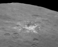
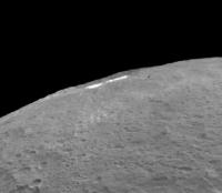
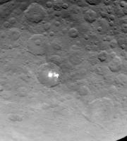
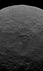
The latest image has a nice perspective that shows some topography:
 and of course, a nice view of a bright crater: 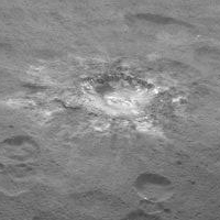 Also some dome-like structures visible in other places? -------------------- |
|
|
|
|
Jun 16 2015, 05:01 PM
Post
#4
|
||
 Member Group: Members Posts: 714 Joined: 3-January 08 Member No.: 3995 |
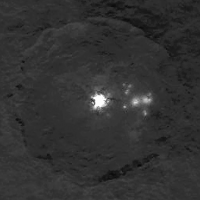
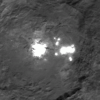
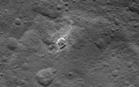
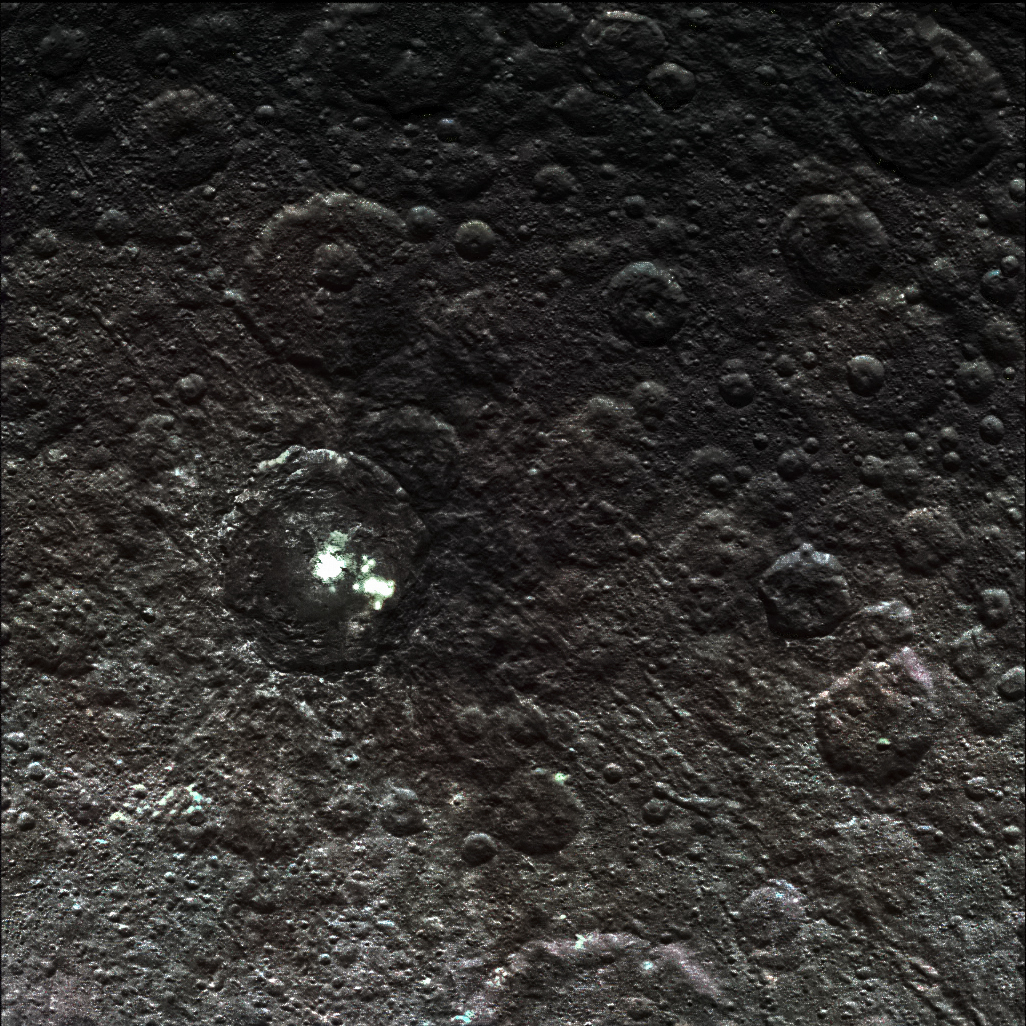
The other white-spot crater looks quite messy, but in a good way:
(Cropped image 2x, not resampled.) It does looks like the impact scored a direct hit on an isolated pocket of the white stuff. |
|
|
|
|
|
|
Jun 16 2015, 05:44 PM
Post
#5
|
|
|
Senior Member Group: Members Posts: 2920 Joined: 14-February 06 From: Very close to the Pyrénées Mountains (France) Member No.: 682 |
Danielle's experiment seams quite close to this: splash!
-------------------- |
|
|
|
|
Jun 17 2015, 01:17 AM
Post
#6
|
||
|
Member Group: Members Posts: 714 Joined: 3-January 08 Member No.: 3995 |
QUOTE (Habukaz @ Jun 16 2015, 11:54 AM) That is the row of three mountains seen earlier. A map of the general area (thanks, Greenish for the map):
|
|
|
|
|
|
|
Jun 17 2015, 04:28 PM
Post
#7
|
||
 Junior Member Group: Members Posts: 66 Joined: 3-August 12 Member No.: 6454 |
A different view of that pingo/volcano/whatever and more white stuff.....
|
|
|
|
|
|
|
Jun 17 2015, 04:48 PM
Post
#8
|
||
|
Member Group: Members Posts: 714 Joined: 3-January 08 Member No.: 3995 |
FYI, the released TIFS have much better detail than the JPGs.
That mound just seems to have no rhyme or reason. If anything, it resembles a volcanic dome ( https://en.wikipedia.org/wiki/Lava_dome ). |
|
|
|
|
|
|
Jun 17 2015, 05:02 PM
Post
#9
|
|
|
Member Group: Members Posts: 423 Joined: 13-November 14 From: Norway Member No.: 7310 |
shield volcano is the word that comes to mind when I see that thing. I wonder how old it is (whatever it is); there are hints of what could be craters on its slopes.
-------------------- |
|
|
|
|
Jun 17 2015, 05:13 PM
Post
#10
|
||
|
Member Group: Members Posts: 714 Joined: 3-January 08 Member No.: 3995 |
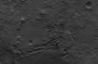
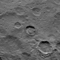
The fossae bundle again:
The square arrangement of features is interesting. |
|
|
|
|
|
|
Jun 17 2015, 05:48 PM
Post
#11
|
||
|
Senior Member Group: Members Posts: 2920 Joined: 14-February 06 From: Very close to the Pyrénées Mountains (France) Member No.: 682 |
QUOTE (Gladstoner @ Jun 17 2015, 06:48 PM) FYI, the released TIFS have much better detail than the JPGs.
That mound just seems to have no rhyme or reason. If anything, it resembles a volcanic dome ( https://en.wikipedia.org/wiki/Lava_dome ). Same but with a wider perspective: https://twitter.com/nasa_dawn/status/611222468942934017 -------------------- |
|
|
|
|
|
|
Jun 17 2015, 06:29 PM
Post
#12
|
|
|
Member Group: Members Posts: 423 Joined: 13-November 14 From: Norway Member No.: 7310 |
The images at full resolution are as usual found at the Photjournal and the Dawn website. The Twitter account rarely provides anything unique other than some extra image description (like characterising the bright crater (spot 1) in yesterday's images as young) and status updates.
-------------------- |
|
|
|
|
Jun 17 2015, 07:55 PM
Post
#13
|
|
|
Junior Member Group: Members Posts: 48 Joined: 10-September 06 Member No.: 1129 |
Are we sure that volcano-looking feature isn't a crater? Sometimes it's hard to tell if something is a mound or a hollow.
|
|
|
|
|
Jun 17 2015, 08:03 PM
Post
#14
|
|
|
Member Group: Members Posts: 714 Joined: 3-January 08 Member No.: 3995 |
QUOTE (Superstring @ Jun 17 2015, 01:55 PM) Are we sure that volcano-looking feature isn't a crater? Sometimes it's hard to tell if something is a mound or a hollow. Definitely a mountain. QUOTE (Zelenyikot @ May 11 2015, 03:36 PM)  |
|
|
|
|
Jun 17 2015, 11:16 PM
Post
#15
|
|
|
Junior Member Group: Members Posts: 88 Joined: 8-May 14 Member No.: 7185 |
QUOTE (Gladstoner @ Jun 17 2015, 06:48 PM) That mound just seems to have no rhyme or reason. If anything, it resembles a volcanic dome ( https://en.wikipedia.org/wiki/Lava_dome ). Perhaps a tip of rocky core poking out through a globe of dust? |
|
|
|
|
Jun 17 2015, 11:31 PM
Post
#16
|
|
 Member Group: Members Posts: 120 Joined: 26-May 15 From: Rome - Italy Member No.: 7482 |
QUOTE (climber @ Jun 16 2015, 05:44 PM) Danielle's experiment seams quite close to this: splash! Yes climber :-) 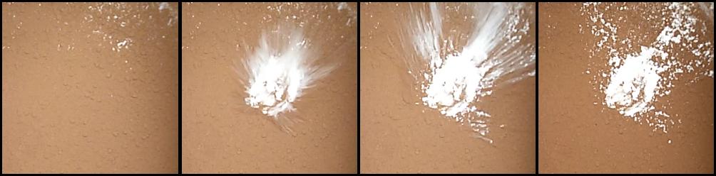 I'm enthusiastic for new images, in particular for the Mouns.. . |
|
|
|
|
Jun 18 2015, 08:20 AM
Post
#17
|
|
|
Member Group: Members Posts: 423 Joined: 13-November 14 From: Norway Member No.: 7310 |
According to the Twitter account, the mountain is about 5 km tall.
-------------------- |
|
|
|
|
Jun 18 2015, 11:51 AM
Post
#18
|
|
|
Member Group: Members Posts: 120 Joined: 26-May 15 From: Rome - Italy Member No.: 7482 |
QUOTE (Habukaz @ Jun 18 2015, 09:20 AM) According to the Twitter account, the mountain is about 5 km tall. I enjoy this... i have supposed that this mount more 4000 mt Tall at the first image of May :-) (in recently image i have supposeD 6'500mt tall, but I probably wrong) it's possible compare at some italian volcanoes (5000 mt tall supposed): 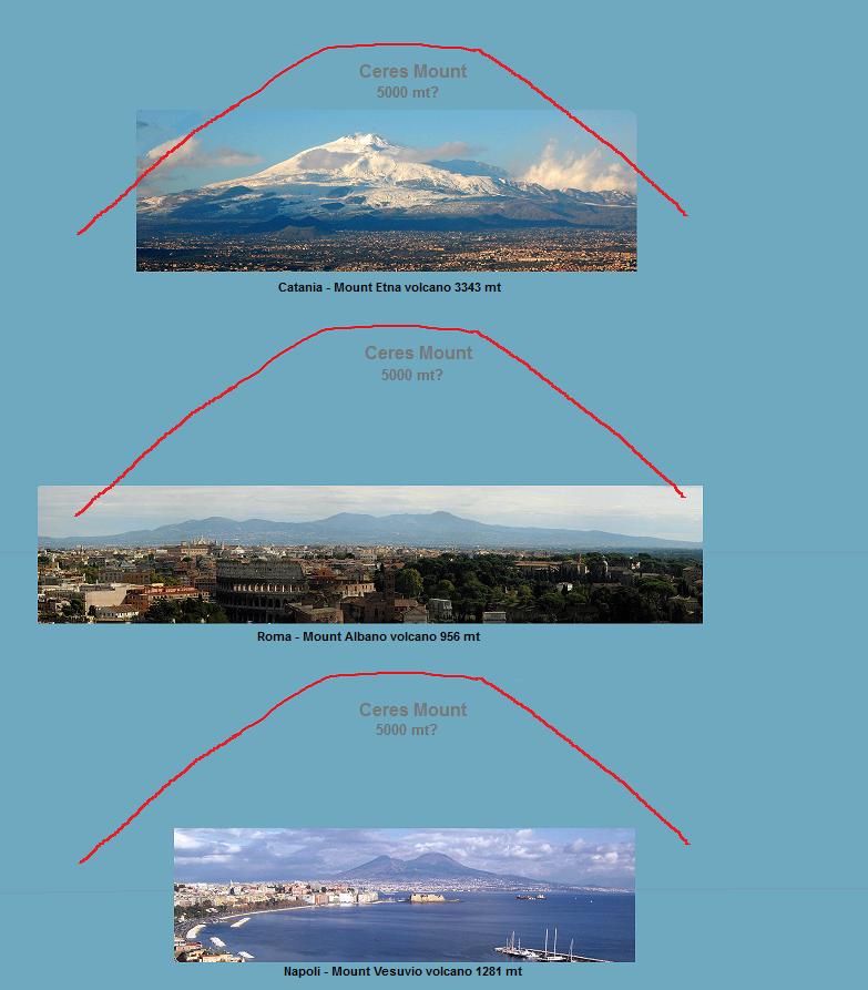
|
|
|
|
|
Jun 18 2015, 04:10 PM
Post
#19
|
|
|
Junior Member Group: Members Posts: 78 Joined: 20-September 14 Member No.: 7261 |
QUOTE (Habukaz @ Jun 18 2015, 10:20 AM) According to the Twitter account, the mountain is about 5 km tall. Personally i find that 70+-km long "cliff" in the center of that image just as, if not more interesting. How do you get that? It's not a crater rim (unless we got some really serious erosion otherwise there), it's not some sort of "cave-in" depression below. What it looks like at best to me is tectonic activity folding it up, but uh... we don't get tectonics on Ceres, do we? |
|
|
|
|
Jun 18 2015, 04:21 PM
Post
#20
|
|
|
Solar System Cartographer Group: Members Posts: 10164 Joined: 5-April 05 From: Canada Member No.: 227 |
Actually it is a crater rim, part of the biggest impact basin we have been seeing in several recent hemisphere-scale images, like this one:
http://dawn.jpl.nasa.gov/multimedia/images...tml?id=PIA19557 (note that image is flipped left-right, the new one is not) Phil -------------------- ... because the Solar System ain't gonna map itself.
Also to be found posting similar content on https://mastodon.social/@PhilStooke Maps for download (free PD: https://upload.wikimedia.org/wikipedia/comm...Cartography.pdf NOTE: everything created by me which I post on UMSF is considered to be in the public domain (NOT CC, public domain) |
|
|
|
|
Jun 18 2015, 05:05 PM
Post
#21
|
||
 Senior Member Group: Members Posts: 1639 Joined: 5-March 05 From: Boulder, CO Member No.: 184 |
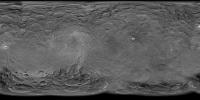
Indeed it's good to look at the context to see the entire basin that raised rim is a part of. Here is an updated map, now with a second image from the survey orbit that shows a closeup of this raised rim and nearby conical mountain. In honor of this closer orbit the resolution of the map is now increased to 8K.
Full 8K resolution and polar views are here -------------------- Steve [ my home page and planetary maps page ]
|
|
|
|
|
|
|
Jun 18 2015, 05:15 PM
Post
#22
|
|
|
Member Group: Members Posts: 714 Joined: 3-January 08 Member No.: 3995 |
|
|
|
|
|
Jun 18 2015, 06:29 PM
Post
#23
|
|
|
Member Group: Members Posts: 120 Joined: 26-May 15 From: Rome - Italy Member No.: 7482 |
it'real this color images of CerES?
|
|
|
|
|
Jun 18 2015, 08:02 PM
Post
#24
|
|
 Senior Member Group: Members Posts: 1088 Joined: 19-February 05 From: Close to Meudon Observatory in France Member No.: 172 |
QUOTE (Daniele_bianchino_Italy @ Jun 18 2015, 01:51 PM) I enjoy this... i have supposed that this mount more 4000 mt Tall at the first image of May :-) (in recently image i have supposeD 6'500mt tall, but I probably wrong) it's possible compare at some italian volcanoes (5000 mt tall supposed): Although not a volcano, Monte Bianco should be the same size ! 
|
|
|
|
|
Jun 18 2015, 09:52 PM
Post
#25
|
||
|
Senior Member Group: Members Posts: 1639 Joined: 5-March 05 From: Boulder, CO Member No.: 184 |
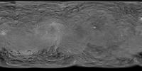
QUOTE (Gladstoner @ Jun 18 2015, 05:15 PM) Now the lesser southern basin is being showcased: Indeed this image fits in nicely to help map out the basins, including features such as the fossae bundle. Thus here is a quick updated map.
Full 8K resolution and polar views are here -------------------- Steve [ my home page and planetary maps page ]
|
|
|
|
|
|
|
Jun 18 2015, 10:18 PM
Post
#26
|
||
|
Member Group: Members Posts: 120 Joined: 26-May 15 From: Rome - Italy Member No.: 7482 |
QUOTE (Gladstoner @ Jun 17 2015, 06:13 PM) The fossae bundle again:
The square arrangement of features is interesting. fantastic this Fossae. . I Hope in a great resolution |
|
|
|
|
|
|
Jun 19 2015, 05:07 AM
Post
#27
|
|
 Member Group: Members Posts: 146 Joined: 22-November 14 From: Bormida (SV) - Italy Member No.: 7348 |
QUOTE (Daniele_bianchino_Italy @ Jun 18 2015, 08:29 PM) it'real this color images of CerES? Hi there, is a bit of time that I cannot come back here (it's not a good time) but I'm continuing to read. So, Daniele the color of these images can not be obviously real (they are black and white). Original files are on our Flickr album: https://flic.kr/p/tPP6Cq - https://flic.kr/p/tG8GKv In the description you will find a "vc" which stands for "virtual color" (we'll try to be more explicit but generally we are always in a hurry!). They were obtained with the same technique that we used many times for the Rosetta's comet. Although the colors may match with a good approximation to reality, the main purpose of making a black and white image in color is to emphasize the details. On the other hand, we find that our eye perceives really better in color. -------------------- |
|
|
|
|
Jun 19 2015, 06:13 AM
Post
#28
|
||
 Member Group: Members Posts: 238 Joined: 15-January 13 Member No.: 6842 |
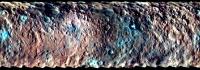
QUOTE (eliBonora @ Jun 19 2015, 06:07 AM) Hi there, is a bit of time that I cannot come back here (it's not a good time) but I'm continuing to read. So, Daniele the color of these images can not be obviously real (they are black and white). Original files are on our Flickr album: https://flic.kr/p/tPP6Cq - https://flic.kr/p/tG8GKv In the description you will find a "vc" which stands for "virtual color" (we'll try to be more explicit but generally we are always in a hurry!). They were obtained with the same technique that we used many times for the Rosetta's comet. Although the colors may match with a good approximation to reality, the main purpose of making a black and white image in color is to emphasize the details. On the other hand, we find that our eye perceives really better in color. There is a (somewhat false-) global colour map of Ceres, taken at near-infrared, green, and blue wavelengths:
Perhaps you could use that colour information in your images? I'd imagine that the surface's appearance at near-infrared would be similar to what it looks like at red wavlengths. ~~~ Regarding the "mountain", did NASA or any other scientific organisation post an estimate of what it could be? -------------------- Curiosity rover panoramas: http://www.facebook.com/CuriosityRoverPanoramas
My Photosynth panoramas: http://photosynth.net/userprofilepage.aspx...;content=Synths |
|
|
|
|
|
|
Jun 19 2015, 08:20 AM
Post
#29
|
|
|
Member Group: Members Posts: 120 Joined: 26-May 15 From: Rome - Italy Member No.: 7482 |
QUOTE Hi there, is a bit of time that I cannot come back here (it\'s not a good time) but I\'m continuing to read. So, Daniele.. I have taken from another website Molte Grazie eli Thanks ;-) QUOTE Although not a volcano, Monte Bianco should be the same size ! yes viking, But Monte Bianco is set in the Alps complex, while volcanoes leave from the sea floor, they make more idea :-) kilimangiaro:  bromo: 
|
|
|
|
|
Jun 19 2015, 04:46 PM
Post
#30
|
||
|
Member Group: Members Posts: 714 Joined: 3-January 08 Member No.: 3995 |
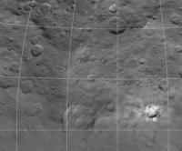
Spot #5 is nearly on the horizon in today's image:
|
|
|
|
|
|
|
Jun 19 2015, 05:42 PM
Post
#31
|
|
|
Member Group: Members Posts: 423 Joined: 13-November 14 From: Norway Member No.: 7310 |
At first I thought it was some other bright material, but I guess you are right. It's kind of counterintuitive that the bright material inside the crater should be visible from this angle.
-------------------- |
|
|
|
|
Jun 19 2015, 06:15 PM
Post
#32
|
|
 Member Group: Members Posts: 555 Joined: 27-September 10 Member No.: 5458 |
That does seem pretty strange. Must be peering just over the crater rim.
-------------------- |
|
|
|
|
Jun 19 2015, 07:25 PM
Post
#33
|
|
|
Senior Member Group: Members Posts: 3516 Joined: 4-November 05 From: North Wales Member No.: 542 |
As I mentioned before don't forget that the curvature of Ceres applies as much along the line of sight as it does around the limb. Big craters have convex floors.
|
|
|
|
|
Jun 19 2015, 08:40 PM
Post
#34
|
|
|
Member Group: Members Posts: 146 Joined: 22-November 14 From: Bormida (SV) - Italy Member No.: 7348 |
QUOTE (wildespace @ Jun 19 2015, 08:13 AM) Perhaps you could use that colour information in your images? I'd imagine that the surface's appearance at near-infrared would be similar to what it looks like at red wavlengths. Yes, I know, it would be possible but maybe be worth waiting for better definitions .. and they are coming!
-------------------- |
|
|
|
|
Jun 19 2015, 10:50 PM
Post
#35
|
||
|
Senior Member Group: Members Posts: 1639 Joined: 5-March 05 From: Boulder, CO Member No.: 184 |
Today's image also helps in mapping some of the terrain just south of spot #5.
Full 8K resolution and polar views are here. -------------------- Steve [ my home page and planetary maps page ]
|
|
|
|
|
|
|
Jun 20 2015, 05:50 AM
Post
#36
|
|
|
Member Group: Members Posts: 146 Joined: 22-November 14 From: Bormida (SV) - Italy Member No.: 7348 |
Here a Ceres mosaic (PIA19575 and 19576)
-------------------- |
|
|
|
|
Jun 20 2015, 07:04 AM
Post
#37
|
|
|
Member Group: Members Posts: 315 Joined: 1-October 06 Member No.: 1206 |
Now that basin is fascinating, not just for the radial valleys, but for the darker mare-like features on its floor. Someone needs to do some crater counting there when the resolution gets good enough!
Also, whats with that lobate feature to the right of the basin which terminates near those fossae? Almost looks like the basin has overflowed (cryo?)mare materials in the past. Does anyone else see that? P |
|
|
|
|
Jun 20 2015, 08:49 AM
Post
#38
|
|
 Member Group: Members Posts: 495 Joined: 12-February 12 Member No.: 6336 |
QUOTE (antipode @ Jun 20 2015, 09:04 AM) Also, whats with that lobate feature to the right of the basin which terminates near those fossae? Almost looks like the basin has overflowed (cryo?)mare materials in the past. Does anyone else see that? Of course we do see it. That part immediately caught my eye also on the image composite that eliBonora provided. It seem that the crater walls might be slowly filling slowly, if that turn out to be correct they truly would be doing so at a glacial pace. I cant stop wondering if those larger chunks might be ice or aggregations of the darker surface material that stick together. In addition there appear to be terrace all round the southern half of the crater that make it seem that the southern region got a higher elevation. |
|
|
|
|
Jun 20 2015, 03:11 PM
Post
#39
|
|
|
Member Group: Members Posts: 112 Joined: 31-January 15 From: Houston, TX USA Member No.: 7390 |
If Ceres still has a glacial fill process that continues today, shouldn't we see some of those small to mid-sized craters partially filled or at least distorted? To me the current surface still looks old. I see Ceres as a body that was one-time active but has now cooled to a point that the surface is no longer active. Any modifications are only done by crater impacts.
Below the surface, we'll have to wait and see what the data says. Andy |
|
|
|
|
Jun 20 2015, 05:25 PM
Post
#40
|
|
|
Member Group: Members Posts: 495 Joined: 12-February 12 Member No.: 6336 |
Distorted craters could indeed show us something.
Now that the area right of that large crater show quite less craters than on average, whereas areas north of the crater are literally peppered. Do this mean that craters have been removed, and only later replaced more recently by a few small craters just at the limit of the image resolution? And yes, one of the largest ones near the right side of the image actually is distorted. But we will need higher resolution images before this little hypothesis will fly or be turned over end, most craters in the area are too small to show any detail yet. |
|
|
|
|
Jun 20 2015, 06:36 PM
Post
#41
|
|
|
Member Group: Members Posts: 555 Joined: 27-September 10 Member No.: 5458 |
QUOTE (alk3997 @ Jun 20 2015, 09:11 AM) To me the current surface still looks old. I see Ceres as a body that was one-time active but has now cooled to a point that the surface is no longer active. The surface certainly looks old and battered yes but much younger than a lot of other icy bodies that have been studied. For floating in the asteroid belt, Ceres appears remarkably smooth in a lot of places suggesting some amount of occasional resurfacing in those areas in geologically recent times. I haven't heard much about the possibility of a periodic atmosphere around Ceres recently. Has there been any more debate on this? We are unfortunately nearly in the dead of winter on Ceres right now. Has this been laid to rest since that article? There wasn't ever much as far as details on the speculation anyway. -------------------- |
|
|
|
|
Jun 20 2015, 10:11 PM
Post
#42
|
|
|
Senior Member Group: Members Posts: 3516 Joined: 4-November 05 From: North Wales Member No.: 542 |
QUOTE (ZLD @ Jun 20 2015, 07:36 PM) The surface certainly looks old and battered yes but much younger than a lot of other icy bodies that have been studied Could be just a little bit younger if all the big land-forming action happened early on. The process exposing the white spots on the other hand must be recent and ongoing. |
|
|
|
| Guest_Steve5304_* |
Jun 21 2015, 04:07 AM
Post
#43
|
|
|
Guests |
QUOTE (Gladstoner @ Jun 19 2015, 04:46 PM) Spot #5 is nearly on the horizon in today's image:
This image makes ice look plausible...as much as i want it to be somthing like diamonds or aliens.. I am still not convinced the bright spots anomaly was almost entirely blown out of proportion by exposure of the camera. |
|
|
|
|
|
|
Jun 21 2015, 02:09 PM
Post
#44
|
|
|
Member Group: Members Posts: 112 Joined: 31-January 15 From: Houston, TX USA Member No.: 7390 |
QUOTE (TheAnt @ Jun 20 2015, 11:25 AM) Distorted craters could indeed show us something. Now that the area right of that large crater show quite less craters than on average, whereas areas north of the crater are literally peppered. Do this mean that craters have been removed, and only later replaced more recently by a few small craters just at the limit of the image resolution? And yes, one of the largest ones near the right side of the image actually is distorted. But we will need higher resolution images before this little hypothesis will fly or be turned over end, most craters in the area are too small to show any detail yet. Yes, all good questions. The large craters with the apparently filled-in, but cratered, floors have intrigued me. Perhaps at a large enough kinetic energy an impact breaks through the crust into the subsurface ocean and allows the floors to be filled for a very short period of time. Over time the crust has become thicker and so more kinetic energy is needed to break on through to the other side - the subsurface ocean and allow flows to occur. The deeper the ocean, the shorter the time before the opening freezes again. This is why only the big craters show signs of resurfacing and yet have middle to small craters within them. Over geologic time it has required more and more impact kinetic energy to cause a flow to occur. The crust near the equator is shallower than near the poles which would explain the differences in large crater density between the equator and the poles. Andy |
|
|
|
|
Jun 22 2015, 02:42 AM
Post
#45
|
|
|
Member Group: Members Posts: 890 Joined: 18-November 08 Member No.: 4489 |
QUOTE Perhaps at a large enough kinetic energy an impact breaks through the crust into the subsurface ocean and allows the floors to be filled for a very short period of time. Over time the crust has become thicker and so more kinetic energy is needed to break on through to the other side - the subsurface ocean and allow flows to occur. The deeper the ocean, the shorter the time before the opening freezes again. this thing is way too small and there is no "jupiter" to tug at it it has been a solid bit of ice and rock for a VERY long time and has been DEEP COLD for a very long time impacts on "high ice " content are VERY different than on a rock or on nickel /iron you get very FLAT floors on the impacts in ices |
|
|
|
|
Jun 22 2015, 04:26 AM
Post
#46
|
|
 Senior Member Group: Members Posts: 3419 Joined: 9-February 04 From: Minneapolis, MN, USA Member No.: 15 |
I imagine that impacts onto an ice world (or an icy-rocky-slush world) generate internal heating from acoustic/seismic energy propagating through the body. As we can see, there have been a lot of large impacts on Ceres. so there has been at least localized heating capable of melting ice, at least for a time. I'm not saying that a peppering of impacts could keep the core continuously warm -- I'm just saying that, when it gets really whacked and a big crater or basin is formed, I bet that anything from very localized to larger-area heating occurs. Chaos being what it is, I can imagine pockets of water melting out inside the crust from such large impacts, refreezing, and then getting exhumed by later impact and tectonic forces.
This could mean that Ceres may have been dead, for all intents and purposes, for billions of years, but that a good, solid whack could make it wheeze and burp a bit, even now. I think when we get a better feel for the compositions of the various texture/albedo/color units, it will tell us a lot more about the possible histories of this curious little world. -the other Doug -------------------- The trouble ain't that there is too many fools, but that the lightning ain't distributed right. -Mark Twain
|
|
|
|
|
Jun 22 2015, 10:56 AM
Post
#47
|
|
|
Senior Member Group: Members Posts: 2346 Joined: 7-December 12 Member No.: 6780 |
Thinking at pockets of water:
The core of Ceres is probably still warm by radioactive decay heat of long-lived isotopes. "If" the interior is sufficiently warm sufficiently close to the surface, there might have been or still may exist a subsurface ocean. In this case a large impactor could have penetrated or at least have crushed the maybe 30 km icy surface crust and released some of the liquid of the presumed "mantle" ocean, in some remote analogy to a once suggested origin of the mare on our moon, besides a melt-up by kinetic impact energy. Particularly for a large (say a few km diameter) iron-nickel meteorite it shouldn't be too difficult to penetrate the much less dense crust material of Ceres. |
|
|
|
|
Jun 22 2015, 01:45 PM
Post
#48
|
||||
|
Member Group: Members Posts: 555 Joined: 27-September 10 Member No.: 5458 |
New images up on Photojournal.
In order left to right: original crop, light decon, darkened w/ decon.
The smallest spots appear to be resolved but also really fuzzy still? Whats up with that? Strange effect at bottom edge of large spot as well. Sorta looks like CCD bloom but I don't know that I've ever seen a situation where it was so small and also right next to another bloom, without them both merging. And here, we have 4 of them... Just to throw an idea out there: Impact at a location with near surface water, creating the typical central peak in the crater but with an increase localized heating and pressure in the subsurface water. Water ejects through the peak in a one time eruption, blowing out the side like Mt. St. Helens, scattering salty-icy debris to the right. Sublimation has left the salts behind to slowly decay. Doesn't solve for why we don't see other larger chunks nearby though. -------------------- |
|||
|
|
|
|||
|
Jun 22 2015, 01:50 PM
Post
#49
|
|
|
Junior Member Group: Members Posts: 30 Joined: 22-July 11 Member No.: 6080 |
Gonna take a stab and say they're looking like mini versions of the big pyramid/mountain thingy.
|
|
|
|
|
Jun 22 2015, 02:29 PM
Post
#50
|
||
 Senior Member Group: Members Posts: 4247 Joined: 17-January 05 Member No.: 152 |
What's nice about the new view is that it appears to be a shorter exposure than PIA19568 (but with similar resolution). So in much of the area that was overexposed we can now see detail. Here's a direct comparison with PIA19568:
(All I've done is both frames 2x oversampled and PIA19568 rotated to match PIA19579. Some relative geometrical distortion between the two frames remains.) The "fuzziness" around the two brightest spots on the right side is clearly real (rather than psf), since much smaller details are resolved elsewhere in the frame. The main bright spot is still overexposed in the centre (at least on the public tifs). It seems to me that we'd need considerably better resolution to understand what's going on here... |
|
|
|
|
|
|
Jun 22 2015, 04:48 PM
Post
#51
|
||
|
Member Group: Members Posts: 714 Joined: 3-January 08 Member No.: 3995 |
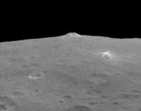
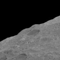
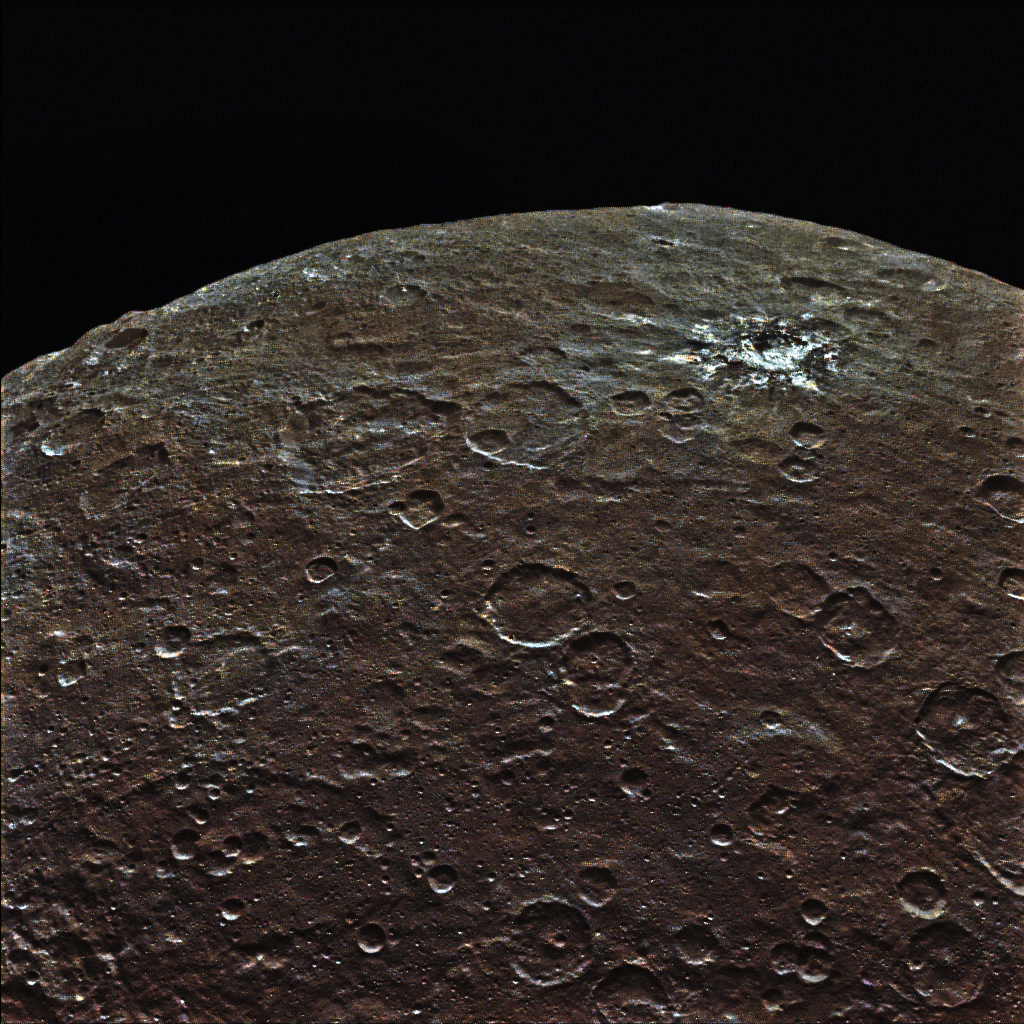
Also today, the big mountain is nicely displayed in profile:
http://photojournal.jpl.nasa.gov/catalog/PIA19578 |
|
|
|
|
|
|
Jun 22 2015, 05:08 PM
Post
#52
|
||
|
Member Group: Members Posts: 714 Joined: 3-January 08 Member No.: 3995 |
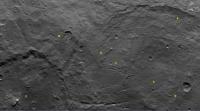
In another image released today (I hope 3-image releases are daily from this point forward....
), a handful of fracture bundles can be seen:
1. The main bundle. 2. Bundle that seems to be associated with dark-albedo material. 3. Another bundle. 4. Bundle on basin wall. 5. Faint hint of bundles that connect 1 and 3. A couple other interesting features: A. A shallow valley seems to merge with a scarp. B. Some material seems to 'slop' into a relatively fresh crater. http://photojournal.jpl.nasa.gov/catalog/PIA19577 |
|
|
|
|
|
|
Jun 22 2015, 06:41 PM
Post
#53
|
|
|
Member Group: Members Posts: 555 Joined: 27-September 10 Member No.: 5458 |
Can't say with certainty, but it looks like there another long bundle below '4' and above the crater pair, just out of resolution and incidence. Also, there's another at the far right, that would appear to connect to '3' but has been disconnected by an impact, also very faint.
-------------------- |
|
|
|
|
Jun 22 2015, 06:49 PM
Post
#54
|
|
|
Member Group: Members Posts: 112 Joined: 31-January 15 From: Houston, TX USA Member No.: 7390 |
QUOTE (JohnVV @ Jun 21 2015, 08:42 PM) this thing is way too small and there is no "jupiter" to tug at it it has been a solid bit of ice and rock for a VERY long time and has been DEEP COLD for a very long time impacts on "high ice " content are VERY different than on a rock or on nickel /iron you get very FLAT floors on the impacts in ices Yes, I agree that at those temperatures ice is harder than rock. Ceres surface today looks old to me, so I don't believe there are any active flows going on right now. However, subsurface there are other factors that *could* be working to make water slush (or water), which could then get exposed by high kinetic energy impacts. As Gerald said long lived radioactive isotopes can provide some heat. While tidal heating isn't possible, the pressures under the crust can provide pockets of heating. Throw in some speculated salts and now the freezing point of the liquid is a little lower. Then add in heat transfer from a high energy object impacting and there could be enough heat for a water flow to occur with a large high velocity impact. As for how the flow would look, I would expect a wave-like feature that freezes rather quickly. Maybe something like the southern rim of this crater? (Provided by user eliBonora) https://www.flickr.com/photos/lunexit/18344202083/ All that said, I'm willing to wait for the detailed gravity measurements to see if there is a possibility that Ceres still has anything liquid in its interior. Andy |
|
|
|
|
Jun 22 2015, 06:59 PM
Post
#55
|
||
|
Member Group: Members Posts: 714 Joined: 3-January 08 Member No.: 3995 |
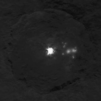
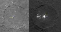
A comparison of craters:
The shape of the main bright spot seems to be similar to the form of the central pit in the other crater. Colored arrows point to possibly similar topographic features. Blue arrows mark high points. Yellow marks breaches in the pit walls. These features (superficially) remind me of the 'capes' and 'bays' of Victoria Crater on Mars. |
|
|
|
|
|
|
Jun 22 2015, 08:49 PM
Post
#56
|
|
|
Member Group: Members Posts: 153 Joined: 20-December 14 From: Eastbourne, UK Member No.: 7372 |
I would guess the left of the two basins is newer. (Gladstone's previous post.) It has resulted from an impact on the edge of the older basin and is considerably deeper. The crust has been pushed down by the later impact, fracturing the surface and enabling the flow of dust on inclined surfaces.
This is more a conjecture. The left basin has steep terraced sides to the south, but far less well defined rims in its northern half. If the impact was at the edge of the ancient ocean and the totally frozen/rocky Southern polar "continent", the southern crater wall would appear as a normal stepped terrace, the northern crater wall collapsed and less well defined. Also the pressure of the impact would force liquid away from the impact site in the ocean below, allowing the crust to collapse. This collapse would stop at the shore line of the subsurface solid "continent" and indeed such a shore line can be made out and the bowl shape of the collapsed crust made out in an semi circle around the northern crater rim. The centre of the crater appears to be almost dead on the shore line and there is half a central peak, its northern face is missing, either via collapse or sublimation. It is also particularly clear that North of the shore line the surface is way more smooth and shows very few deep impacts, clear signs of resurfacing and linear scarring indicating expansion/contraction or movement of the surface crust. The darker areas of the poles indicates older less recycled surface. There may not be a dust cycle as dramatic as on 67P, the gravity on Ceres prevents sublimating gases moving dust very far, but where volatile ices are near to the surface, dust will move and resurface the comet. I would suggest this is happening on a very small scale now, but in the past when the crust was thinner and in areas where the crust has been thinned or penetrated by impacts, the movement of dust by sublimating gases would have been significant enough to resurface the comet on a local level. It could be that at a low level this is what is keeping some areas of exposed ice/salt exposed, the subsurface sublimating gases escaping at the surface preventing dust settling to recover the exposed areas. Once all the volatiles are exhausted the surface becomes covered in dust. If the volatiles are being replaced by more from below, say in a very deep crater or fissure, the dust could be held at bay for a significant length of time. Following on from that, how many of the craters on Ceres are impact craters and how many sublimation derived features such as those on 67P? An explosion of pressurised, sublimated gases within the crust could leave craters similar to Spot 1 for instance, the ejecta being the unexposed ice of the crust dispersed by the explosion. It might prove interesting to compare the craters with those left by underground atomic bomb tests. The suggestion of Spot 5 being a central mountain that blew off one of its sides, like Mt St. Helens, seems another example. Ceres is dark and absorbs a lot of sunlight, that heat must travel into the crust and have consequences, such as creating pockets of sublimated gas. Even if an impact does not penetrate to the liquid below it exposes these pockets and increases the possibility of the pressure within resulting in the explosive creation of features on the surface. The strange mountain could be another example, a small high energy impact penetrating a large "magma" chamber of volatile gases, perhaps added to by fluid under pressure escaping from the ocean below. The coming week's pictures may suggest a whole different scenario, so this is just little more than a thought experiment to ferment ideas. We are dealing with a surface crust made largely of Water Ice, most especially, I would suggest, in the equatorial and mid latitudes. The ocean may well not ever have developed in polar regions and the surface there maybe largely made of refractory materials, rock and organics. The shrivelled and shrunken appearance of the surface we see today suggests to me that there are no longer large volumes of Water blow the crust, if any, but there may still be lakes and small seas where the energy of past impacts has locally delayed the slow freeze. |
|
|
|
|
Jun 22 2015, 09:58 PM
Post
#57
|
|
|
Member Group: Members Posts: 423 Joined: 13-November 14 From: Norway Member No.: 7310 |
The fuzziness of the of the bright spots to the right makes me think of cryovolcanic vents spewing out a thin spray of water.
 Though I guess them being miniature versions of e.g. the bright crater we saw earlier is still a good explanation. -------------------- |
|
|
|
|
Jun 23 2015, 12:27 AM
Post
#58
|
|
|
Senior Member Group: Members Posts: 3419 Joined: 9-February 04 From: Minneapolis, MN, USA Member No.: 15 |
If you're right, Habukaz, then this makes two different sets of features that resemble cryovolcanic versions of fire fountains. At region 5, here, very bright effluent has been emplaced, while in other areas, near the scratch-like wrinkle features, dark material seems to have been emplaced.
I wonder if the same processes are generating both types of features, the difference being the specific type of "lava" being generated. I know that, on the Moon, differences in the lavas feeding the various fire fountains generated glasses ranging in color from green to red to black -- could different cryo-lava constituents determine whether you get a high-albedo unit emplaced vs. a low-albedo unit? -the other Doug -------------------- The trouble ain't that there is too many fools, but that the lightning ain't distributed right. -Mark Twain
|
|
|
|
|
Jun 23 2015, 02:35 AM
Post
#59
|
|
|
Member Group: Members Posts: 112 Joined: 31-January 15 From: Houston, TX USA Member No.: 7390 |
But, what about the side view image that Gladstoner uplinked on page 2?
http://www.unmannedspaceflight.com/index.p...st&id=36162 Shouldn't we see something resembling relief, if not a fountain, in this image? I'm not saying I understand the bright spots, but I still have doubts over an active vent/cryovolcanism. Andy |
|
|
|
|
Jun 23 2015, 03:27 AM
Post
#60
|
|
|
Senior Member Group: Members Posts: 3419 Joined: 9-February 04 From: Minneapolis, MN, USA Member No.: 15 |
Ooops, sorry. I see that I mis-spoke a bit. I didn't mean to say we were seeing active fountains, I meant we may be seeing the results of fountain-like activity in the past having emplaced very high-albedo material at S5, and very low albedo material in other places, like the "scratches" type formation that has been noted to be surrounded by dark terrain.
I was referring to the end effect of such fountain activity, not trying to say it's happening right now. Sort of hard to say how long ago something like that might have happened, though. It will help enormously when we start getting some compositional clues. -the other Doug -------------------- The trouble ain't that there is too many fools, but that the lightning ain't distributed right. -Mark Twain
|
|
|
|
|
Jun 23 2015, 03:33 AM
Post
#61
|
|
|
Member Group: Members Posts: 112 Joined: 31-January 15 From: Houston, TX USA Member No.: 7390 |
QUOTE (dvandorn @ Jun 22 2015, 10:27 PM) Ooops, sorry. I see that I mis-spoke a bit. I didn't mean to say we were seeing active fountains, I meant we may be seeing the results of fountain-like activity in the past having emplaced very high-albedo material at S5, and very low albedo material in other places, like the "scratches" type formation that has been noted to be surrounded by dark terrain. I was referring to the end effect of such fountain activity, not trying to say it's happening right now. Sort of hard to say how long ago something like that might have happened, though. It will help enormously when we start getting some compositional clues. -the other Doug I misunderstood - sorry about that. I won't be surprised if this turns out to be the result of some type of past cryovolcanic activity. The one thing I'm having problems with is figuring out how anything that is this relatively bright remains this relatively bright while being subjected to eons of solar radiation (and other types of particle radiation). I just can't get past that yet. Andy |
|
|
|
|
Jun 23 2015, 08:33 AM
Post
#62
|
|
|
Member Group: Members Posts: 423 Joined: 13-November 14 From: Norway Member No.: 7310 |
I was also thinking about the coating produced by such activity. I do think it could still be active though - any spray of water could be so tenuous that Dawn's cameras would not be able to detect it under even the best of conditions. If such a spray was thick enough to be easily seen, I guess the results (ice coating) would be a lot more dramatic than the bright spots we see.
-------------------- |
|
|
|
|
Jun 23 2015, 01:39 PM
Post
#63
|
|
|
Member Group: Members Posts: 555 Joined: 27-September 10 Member No.: 5458 |
If active, what about some type of water slurry cryomagma? This would flow out like lava here on Earth, down the sides of whatever formation is there, or build up into a dome if thats the case. As it cools, it would probably frost over leaving a fuzzy looking, semi-transparent film, depending on non-water particle content. Still looking through research papers on the topic but the topic of what happens after the cryomagma is out in the open, is less interesting to discuss.
-------------------- |
|
|
|
|
Jun 23 2015, 02:40 PM
Post
#64
|
|
|
Merciless Robot Group: Admin Posts: 8784 Joined: 8-December 05 From: Los Angeles Member No.: 602 |
Re the possibility of active plumes: As I recall, there was at least one terrestrial spectroscopic observation of a water vapor transient a few years back & the estimated total quantity of material was quite small, perhaps a few hundred kilograms. Presumably a surface feature erupting continuously enough to appear blurred in Dawn imagery would produce a far larger amount of water vapor over time with a correspondingly larger spectroscopic signature.
I don't know if similar observations are underway right now, but given the above it seems unlikely that we're seeing an active eruption here. -------------------- A few will take this knowledge and use this power of a dream realized as a force for change, an impetus for further discovery to make less ancient dreams real.
|
|
|
|
|
Jun 23 2015, 04:06 PM
Post
#65
|
|
|
Member Group: Members Posts: 555 Joined: 27-September 10 Member No.: 5458 |
Spectroscopy isn't really my area. What are the prospects of detecting a non-plume like eruption? Say, if it is coming out very slowly as an extremely viscous, ammoniated or sulphated mud.
Full disclosure: I agree that it is extremely unlikely for any activity. -------------------- |
|
|
|
|
Jun 23 2015, 04:52 PM
Post
#66
|
|
|
Member Group: Members Posts: 102 Joined: 8-August 12 Member No.: 6511 |
Something I haven't seen discussed yet: are we seeing any evidence of volatile transport? Ceres regularly warms up to over 200 K in middle and lower latitudes, and at those temperatures water and carbon dioxide ices will have significant vapor pressure. Most volatiles at or near the surface would quickly sublimate and be lost to space, but some might accrete in cold traps -- and there might be ice not far below the surface.
So, first, is there any indication yet of subsidence or other effects that might be attributed to the sublimation of subsurface volatiles over geologic time? And second, is there any sign yet of ice in cold traps? (We didn't find any on Vesta, but Vesta has a large axial tilt -- 27 degrees -- while Ceres has hardly any. And if surface ice can survive on the Moon and Mercury...) Doug M. |
|
|
|
|
Jun 23 2015, 06:08 PM
Post
#67
|
|
|
Merciless Robot Group: Admin Posts: 8784 Joined: 8-December 05 From: Los Angeles Member No.: 602 |
ZLD, I think that the answer is the same. Any semi-liquid substance viscous at Ceres' surface temperature will have a vapor pressure, and since there's no atmosphere there should be a substantial amount of diffusion. Even lava would have volatile fractions (as you mentioned) like sulfur. Ceres is known to be water-rich, though.
Bottom line is that I think we're still seeing the effects of CCD saturation by high-albedo surface solids, not gas or vapor. Whatever that stuff is (and my bet is ice) it's WAY reflective. Gonna require even higher-resolution views to make sense of it. -------------------- A few will take this knowledge and use this power of a dream realized as a force for change, an impetus for further discovery to make less ancient dreams real.
|
|
|
|
|
Jun 23 2015, 06:23 PM
Post
#68
|
|
|
Member Group: Members Posts: 495 Joined: 12-February 12 Member No.: 6336 |
QUOTE (Doug M. @ Jun 23 2015, 06:52 PM) Something I haven't seen discussed yet: are we seeing any evidence of volatile transport? Ceres regularly warms up to over 200 K in middle and lower latitudes, and at those temperatures water and carbon dioxide ices will have significant vapor pressure. Most volatiles at or near the surface would quickly sublimate and be lost to space, but some might accrete in cold traps -- and there might be ice not far below the surface. Interesting question Doug, I did indeed expect a bit of sublimation, and that such might be the source of the tentative reports of water molecules and/or hydroxyl. This could have let frost accumulate closer to the poles, in partially shadowed craters or other suitable locations. But even in the early images we could not see anything such, and that most of Ceres comes with a very dark surface, with only dots of very bright material in very few locations. This surface material might have water incorporated just as have been found on Luna, but that it is buried a bit under the surface also keep it buried and shaded so very little ever evaporate. And that's why I now find that crystals of salts is a strong contender candidate for the bright areas we see, with the possible exception of area 5, which may be ice. |
|
|
|
|
Jun 23 2015, 06:55 PM
Post
#69
|
|
|
Member Group: Members Posts: 154 Joined: 8-June 04 Member No.: 80 |
I understand Dawn has a Gamma Ray and Neutron Detector and a Visible and Infrared Mapping Spectrometer to determine chemical composition. What have they told us about the bright spots on Ceres?
|
|
|
|
|
Jun 23 2015, 07:09 PM
Post
#70
|
|
|
Senior Member Group: Members Posts: 1729 Joined: 3-August 06 From: 43° 35' 53" N 1° 26' 35" E Member No.: 1004 |
QUOTE (pioneer @ Jun 23 2015, 07:55 PM) I understand Dawn has a Gamma Ray and Neutron Detector these two are probably not getting any meaningful signal from the surface in the present high orbit |
|
|
|
|
Jun 23 2015, 07:26 PM
Post
#71
|
|
|
Member Group: Members Posts: 153 Joined: 20-December 14 From: Eastbourne, UK Member No.: 7372 |
I also think sublimation of volatiles may be involved in shaping the surface. I have been trying to explain why the bright spots all over Ceres are not covered in Ceres regolith. Either the precesses creating the bright material are very recent, or even current, or some mechanism is slowing down the recovering process.
If we assume the bright material is Water Ice or frozen brine, sublimation rates would be high, creating a significant "breeze" very close to the surface, which could be sufficient to disturb and remove dust. So if volatiles are ejected onto the surface it may take a considerable length of time for them to be recovered in dust. This image, highly upscaled and zoomed, is of the bright spots in "Spot 5". https://www.flickr.com/photos/124013840@N06...eposted-public/ My interpretation is the largest bright area, on the left, is a sort of Ice "lava" lake sitting inside a Caldera, possibly still being refreshed from below, though highly unlikely. However, the amount of sublimated gas from such a volume of Ice, could keep the area dust free. On the right flank of this Caldera it can be seen that the mound is constructed in layers and lighter, but not bright, "lava" flows can be seen radiating from the central Caldera. Smaller eruptive sites nearby could also create the smaller blotches, they also have slightly lighter "lava" flows radiating from them. They could also be depressions or small craters filled up with fluid ejecta from the larger Cryovolcanos or "Hot Springs", "Geysers" and mud Cryovolcanos. The farthest right appears to have built a sizeable cone too. Once again the resolution is not quite good enough to be sure and a small degree of interpretive license is required. It looks to me that this is, or was, a Cryovolcanically active region. The deep crater it is situated in, suggests the thickness of the Ice crust is very thin in the bottom of the crater and the original impact may have opened a crack in the crust either temporarily or possibly it is still there. Others have traced a fault line running through the crater that appears to run up the right side of the large Caldera, although it could be interpreted as a channel carved by "hot" liquid erupting from the Cryovolcano, it has a "river" like appearance. |
|
|
|
|
Jun 23 2015, 07:27 PM
Post
#72
|
|
|
Solar System Cartographer Group: Members Posts: 10164 Joined: 5-April 05 From: Canada Member No.: 227 |
Paolo's right, GRAND gets pretty much nothing until the very lowest orbit. VIMS can get dood data now, but nothing has been announced yet.
Phil -------------------- ... because the Solar System ain't gonna map itself.
Also to be found posting similar content on https://mastodon.social/@PhilStooke Maps for download (free PD: https://upload.wikimedia.org/wikipedia/comm...Cartography.pdf NOTE: everything created by me which I post on UMSF is considered to be in the public domain (NOT CC, public domain) |
|
|
|
|
Jun 23 2015, 07:39 PM
Post
#73
|
|
|
Senior Member Group: Members Posts: 4247 Joined: 17-January 05 Member No.: 152 |
Apart from this release based on observations in February:
http://photojournal.jpl.nasa.gov/catalog/PIA19316 |
|
|
|
|
Jun 23 2015, 07:47 PM
Post
#74
|
|
|
Member Group: Members Posts: 153 Joined: 20-December 14 From: Eastbourne, UK Member No.: 7372 |
This is interesting. Is this erosion or sedimentary layering?
https://www.flickr.com/photos/124013840@N06...eposted-public/ This is close up from this original. http://www.nasa.gov/sites/default/files/th...a19574-1041.jpg |
|
|
|
|
Jun 23 2015, 07:52 PM
Post
#75
|
|
|
Member Group: Members Posts: 146 Joined: 22-November 14 From: Bormida (SV) - Italy Member No.: 7348 |
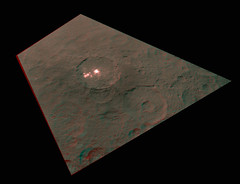
An anagliph of Spot5's crater (from PIA19579 and 568)
-------------------- |
|
|
|
|
Jun 23 2015, 07:55 PM
Post
#76
|
|
|
Member Group: Members Posts: 714 Joined: 3-January 08 Member No.: 3995 |
QUOTE (Sherbert @ Jun 23 2015, 02:47 PM) This is interesting. Is this erosion or sedimentary layering? It is likely a set of fractures. Crater rim slumping comes to mind, but they don't quite line up 'right'. |
|
|
|
|
Jun 23 2015, 08:02 PM
Post
#77
|
|
|
Member Group: Members Posts: 153 Joined: 20-December 14 From: Eastbourne, UK Member No.: 7372 |
[quote name='eliBonora' date='Jun 23 2015, 08:52 PM' post='221699']
An anagliph of Spot5's crater (from PIA19579 and 568) Looking at that, the whole crater could be a Caldera. |
|
|
|
|
Jun 23 2015, 08:06 PM
Post
#78
|
|
|
Member Group: Members Posts: 153 Joined: 20-December 14 From: Eastbourne, UK Member No.: 7372 |
QUOTE (Gladstoner @ Jun 23 2015, 08:55 PM) It is likely a set of fractures. Crater rim slumping comes to mind, but they don't quite line up 'right'. Agreed. Also interesting are some of the hollows in the crater wall, they look similar to formations on 67P, though they could still be the result of impacts. Evidence of multiple resurfacing events maybe? |
|
|
|
|
Jun 23 2015, 08:11 PM
Post
#79
|
|
|
Senior Member Group: Members Posts: 1639 Joined: 5-March 05 From: Boulder, CO Member No.: 184 |
We have discussed this to be a rim section of a larger basin. Is there a secondary process going on in the crater wall?
-------------------- Steve [ my home page and planetary maps page ]
|
|
|
|
|
Jun 23 2015, 10:24 PM
Post
#80
|
|
|
Member Group: Members Posts: 714 Joined: 3-January 08 Member No.: 3995 |
QUOTE (scalbers @ Jun 23 2015, 02:11 PM) Is there a secondary process going on in the crater wall? Probably. They appear to have formed well after the large impact but before the wall slump. The orientation of the fractures probably indicates stresses not directly related to the basin structure. |
|
|
|
|
Jun 23 2015, 10:54 PM
Post
#81
|
|
|
Member Group: Members Posts: 153 Joined: 20-December 14 From: Eastbourne, UK Member No.: 7372 |
This is the same rim wall from a different angle. I still can't decide the cause, fracturing seems plausible, a slightly fortuitous wall slump process or layers made by resurfacing processes prior to the impact that created the basin. In this image the layering can be seen to the right of the steep rim/cliff, which probably rules out cliff slumping. I have added some arrows to point out the 67P like formations and from this view, the layering looks similar to that seen on 67P too. In that light it may just be down to differential erosion due to sublimation of volatiles in the exposed crust. Whatever the cause, its strange it is only seen in this one section of the cliff.
https://www.flickr.com/photos/124013840@N06...eposted-public/ EDIT: If that area of bright material is associated with a Cryovolcanic source, maybe its past "lava" flows? |
|
|
|
|
Jun 23 2015, 11:27 PM
Post
#82
|
|
|
Member Group: Members Posts: 714 Joined: 3-January 08 Member No.: 3995 |
I'm leaning toward it a series of vertical or high-angle fractures mainly because there are a couple similar features nearby on the basin floors.
Also, at this point, I think layering is less likely also because it is the only example observed (so far) in a crater or basin wall. That is, unless the slump just happens to expose a rare example of a section of 'lava' flows or whatever. But then Ceres is already known for its 'unlikely' and isolated features (bright spots, the big mountain). And finally, who knows what will turn up in relatively fresh rim scarps once higher resolution imagery comes in.
|
|
|
|
|
Jun 24 2015, 12:37 AM
Post
#83
|
|
|
Newbie Group: Members Posts: 1 Joined: 15-June 15 Member No.: 7505 |
Newby here. I can construct a hypothesis for the bright spots by taking pieces of the various ideas posted in this thread. 1) Ceres has salts on or very near the surface, which are left over from a time when it was warmer and spewing water/salt mixtures over the surface. 2) Over time, the salts darken upon exposure to radiation. 3) There are occasional impacts into the surface which cause localized heating. If I couple these with the observation that radiation-darkened salt can be bleached back to white upon exposure to heat, then that might explain the distribution of these bright spots. Explicitly, occasional impacts warm the surface, bleaching the ice back to its brighter, higher albedo form until it darkens back over time. The salt deposits would have been preferentially deposited in the lower areas like crater basins, but would otherwise appear sort of randomized, due to the random impacts coming in.
Here is a somewhat relevant reference: http://www.sciencedirect.com/science/artic...19103579901702# I also read a bit that sunlight can bleach some salts back to being bright, but could it be that Ceres is too cold or far from the sun for that to dominate the radiation induced darkening? Anyway, that's my utterly amateur guess. |
|
|
|
|
Jun 24 2015, 05:15 AM
Post
#84
|
|
|
Member Group: Members Posts: 184 Joined: 2-March 06 Member No.: 692 |
Yes. I just can't get my head around how we could be seeing a freshish ice deposit on such an old and probably dead world, so salt it is.
And just to think outside the box, is the bright stuff from an impactor? |
|
|
|
|
Jun 24 2015, 05:49 AM
Post
#85
|
|
|
Merciless Robot Group: Admin Posts: 8784 Joined: 8-December 05 From: Los Angeles Member No.: 602 |
QUOTE (monty python @ Jun 23 2015, 09:15 PM) And just to think outside the box, is the bright stuff from an impactor? Could well be, or exhumed fresh ice from recent impacts. The only way original impactor material could survive in such relatively pristine (and closely grouped) condition would be via a VERY low impact velocity. That would be a more tenable hypothesis if there was just one such feature on Ceres, but there appear to be several. -------------------- A few will take this knowledge and use this power of a dream realized as a force for change, an impetus for further discovery to make less ancient dreams real.
|
|
|
|
|
Jun 24 2015, 03:39 PM
Post
#86
|
|
|
Member Group: Members Posts: 112 Joined: 31-January 15 From: Houston, TX USA Member No.: 7390 |
QUOTE (nprev @ Jun 23 2015, 11:49 PM) Could well be, or exhumed fresh ice from recent impacts. The only way original impactor material could survive in such relatively pristine (and closely grouped) condition would be via a VERY low impact velocity. That would be a more tenable hypothesis if there was just one such feature on Ceres, but there appear to be several. We had discussed the low energy/velocity impactor theory back in one of the earlier threads and I'm certainly still in that "camp", with maybe the impactor actually being a rubble pile. I don't like to use a theory that requires a currently active body when there are still alternatives that fit the available data. One possibility to explain the multiple locations is that there are rubble piles near Ceres orbit that were originally pieces of Ceres until they were excavated by an impact. These almost co-orbitals eventually find there way back to Ceres at a very slow velocity with little mass. Andy |
|
|
|
|
Jun 24 2015, 04:50 PM
Post
#87
|
|
|
Junior Member Group: Members Posts: 59 Joined: 25-December 05 From: Stevens Point, Wisconsin, USA Member No.: 619 |
"....low energy/velocity impactor theory... with maybe the impactor actually being a rubble pile..."
...If that's the case, why didn't we any white spots on, say, Vesta? |
|
|
|
|
Jun 24 2015, 04:58 PM
Post
#88
|
|
|
Member Group: Members Posts: 112 Joined: 31-January 15 From: Houston, TX USA Member No.: 7390 |
QUOTE (rogelio @ Jun 24 2015, 11:50 AM) "....low energy/velocity impactor theory... with maybe the impactor actually being a rubble pile..." ...If that's the case, why didn't we any white spots on, say, Vesta? Very different orbit. http://nssdc.gsfc.nasa.gov/planetary/facts...teroidfact.html |
|
|
|
|
Jun 24 2015, 05:26 PM
Post
#89
|
|
 Senior Member Group: Members Posts: 2530 Joined: 20-April 05 Member No.: 321 |
Some qualitative thinking where computational modeling would be required, but:
If Ceres had a significant subsurface H2O aquifer at some point in the past when it was relatively warmer, and then cooled, then the expanding ice had to go somewhere. Globally, this would cause extension if the stress were applied equally everywhere, but violent venting seems like another apt outcome. There would be subsurface water with ice atop it, the ice layer thickening but subject to the weight of the crust above it. Where it vented, there could be tremendous lateral flow to draw from the water layer worldwide, continuing the eruption for quite some time. The water blasting out at the surface would probably undergo a lot of evaporation and loss into space, although perhaps it could have caused a significant temporary atmosphere. What didn't escape could have caused monumentally large accumulations of ice on the surface. Maybe what we're seeing is the result of a relatively small number of such eruptions, which eventually let out all of the excess pressure caused by the expansion of freezing H2O. |
|
|
|
|
Jun 24 2015, 05:28 PM
Post
#90
|
||
|
Junior Member Group: Members Posts: 71 Joined: 3-February 11 Member No.: 5800 |
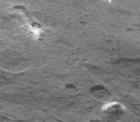
Polar region crater with more of the light coloured material:
|
|
|
|
|
|
|
Jun 24 2015, 05:49 PM
Post
#91
|
||
|
Member Group: Members Posts: 714 Joined: 3-January 08 Member No.: 3995 |
QUOTE (ZLD @ Jun 20 2015, 12:36 PM) .... I haven't heard much about the possibility of a periodic atmosphere around Ceres recently. Has there been any more debate on this? QUOTE (JRehling @ Jun 24 2015, 11:26 AM) .... The water blasting out at the surface would probably undergo a lot of evaporation and loss into space, although perhaps it could have caused a significant temporary atmosphere. .... With darkish, plume-like features like the ones extending from spot #5:
I can't help but think about the possibility of a temporary atmosphere. |
|
|
|
|
|
|
Jun 24 2015, 05:58 PM
Post
#92
|
|||
|
Member Group: Members Posts: 714 Joined: 3-January 08 Member No.: 3995 |
QUOTE (FOV @ Jun 24 2015, 11:28 AM) Polar region crater with more of the light coloured material:
That feature does look similar to this:
Both may be where impacts exposed subsurface intrusions of the white stuff. |
||
|
|
|
||
|
Jun 24 2015, 06:17 PM
Post
#93
|
|
|
Member Group: Members Posts: 423 Joined: 13-November 14 From: Norway Member No.: 7310 |
The lower half of that bright crater has a really strange appearance. Looks like something has modified it (like a later impact or two).
-------------------- |
|
|
|
|
Jun 24 2015, 08:18 PM
Post
#94
|
|||
|
Member Group: Members Posts: 555 Joined: 27-September 10 Member No.: 5458 |
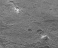
It gets even stranger looking if you flip it upside down.
I almost think an impact actually pushed the soil upward and out into a sort of hanging cliff? Also, another oddity crater from SOrb12
Zero clue here. I got nothing. -------------------- |
||
|
|
|
||
|
Jun 24 2015, 08:26 PM
Post
#95
|
|
|
Senior Member Group: Members Posts: 2530 Joined: 20-April 05 Member No.: 321 |
QUOTE (Gladstoner @ Jun 24 2015, 10:58 AM) Both may be where impacts exposed subsurface intrusions of the white stuff. I'm looking at photos of Ganymede, which has a lot of rayed craters that exposed bright, subsurface ice. The phenomenon on Ceres is definitely something different. Related, perhaps, but every example on Ganymede has common characteristics that none of the examples on Ceres match. If this is a mere "ray" event (also visible on the Moon, Mercury, etc.), then there's something very different on Ceres about how the material is surfaced or how it ages. I'd guess we're either seeing the remnants of a ray system that sputters away quite differently than the rays on Ganymede, et al, do, or these are eruptions. If it were simply subsurface salt, I'd expect them to look like Ganymede/Moon rays and to be less selective in their occurrence. Perhaps icy ray material on Ceres is coarse near the point of origin and sparse far from it and therefore sputters away rapidly except where it's most coarse. Eg, a 20 kg lump of ice may stick around much, much longer than lots of microgram particles. Alternately, I'd stick with the idea of eruptions: Which may be triggered when the impact occurs, or possibly much later. |
|
|
|
|
Jun 24 2015, 09:00 PM
Post
#96
|
|
 Senior Member Group: Members Posts: 2173 Joined: 28-December 04 From: Florida, USA Member No.: 132 |
QUOTE (ZLD @ Jun 24 2015, 03:18 PM) 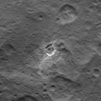 I almost think an impact actually pushed the soil upward and out into a sort of hanging cliff? The white rays spray out in the opposite direction of the dirt pile. It doesn't look like both could be the result of "impact push". Maybe an impactor hit a sub-surface bed of salty ice. The white spray is the salt left from icy ejecta. The impact melted the sub surface ice leading to a sinkhole-like slump on the side of the crater opposite the white rays. I'll try to resist any further amateur speculations. 
|
|
|
|
|
Jun 24 2015, 09:06 PM
Post
#97
|
|
|
Senior Member Group: Members Posts: 3516 Joined: 4-November 05 From: North Wales Member No.: 542 |
QUOTE (JRehling @ Jun 24 2015, 09:26 PM) a 20 kg lump of ice may stick around much, much longer than lots of microgram particles Do you mean long on a geological timescale? Do you have a very rough estimate for the length of time a 20kg lump would last? |
|
|
|
|
Jun 24 2015, 09:10 PM
Post
#98
|
||
|
Member Group: Members Posts: 714 Joined: 3-January 08 Member No.: 3995 |
QUOTE (JRehling @ Jun 24 2015, 03:26 PM) If it were simply subsurface salt, I'd expect them to look like Ganymede/Moon rays and to be less selective in their occurrence. This is why I suspect much of the white stuff is in the form of intrusions (veins, dikes, 'volcanic necks', etc.) in places deep beneath the surface. A terrestrial comparison I have in mind is pegmatite, which is the solid end point of granitic magma crystallization. On Ceres, the 'granite' would be water ice, and the 'pegmatite' would be the leftover material that could not be incorporated into the ice crystals. This 'pegmatitic magma', which would be a concentrated brine containing various salt and volatiles (CO2, NH3, etc.) would either dry or freeze out in place or eventually make it to the surface as an extrusion of some kind. The entrained gases would help to drive the eruption as they do on Earth. Spot #5 could be the best -- or only -- example where this brine breached the surface due to eruption rather than by exposure due to impact or mass wasting. Edit 1: In many spots, this material may merely permeate existing fractures within the megabreccia (think of mineral veins on Mars). In these cases, the intrusions may resemble petroleum reserves more than they do magmatic plutons. Edit 2: And speaking of crater rays, I would not expect exposed water ice to remain for long after an impact excavated and dispersed it like this (assuming all white material is the same stuff):
|
|
|
|
|
|
|
Jun 24 2015, 09:42 PM
Post
#99
|
|
|
Senior Member Group: Members Posts: 2530 Joined: 20-April 05 Member No.: 321 |
I see a citation from Lanzerotti, et al, 1978 to the effect that:
Solar wind erosion for pure water ice is about 10 angstroms per year at 1 AU and falls off with the inverse square of the distance. So, at Ceres, about 3 angstroms per year. At that rate, a 10 cm ice layer would vanish entirely in about 300 million years. That's longer than the age of Tycho on the Moon, and about as old as Aristarchus. So, chunks about 30 cm across would survive near younger craters, but not near older ones, and snowflakes would disappear almost instantly in geological terms. |
|
|
|
|
Jun 24 2015, 09:59 PM
Post
#100
|
|
|
Senior Member Group: Members Posts: 1639 Joined: 5-March 05 From: Boulder, CO Member No.: 184 |
Would the ice sublimation rate be greater than the solar wind erosion rate at the ambient temperatures? The moon provides some guidance:
http://people.nwra.com/resumes/andreas/pub...Icarus_Moon.pdf -------------------- Steve [ my home page and planetary maps page ]
|
|
|
|
 |

|
Lo-Fi Version | Time is now: 21st May 2024 - 12:52 AM |
|
RULES AND GUIDELINES Please read the Forum Rules and Guidelines before posting. IMAGE COPYRIGHT |
OPINIONS AND MODERATION Opinions expressed on UnmannedSpaceflight.com are those of the individual posters and do not necessarily reflect the opinions of UnmannedSpaceflight.com or The Planetary Society. The all-volunteer UnmannedSpaceflight.com moderation team is wholly independent of The Planetary Society. The Planetary Society has no influence over decisions made by the UnmannedSpaceflight.com moderators. |
SUPPORT THE FORUM Unmannedspaceflight.com is funded by the Planetary Society. Please consider supporting our work and many other projects by donating to the Society or becoming a member. |
|