Printable Version of Topic
Click here to view this topic in its original format
Unmanned Spaceflight.com _ Mars _ Orbit-driven climate cycles exposed in sedimentary layers
Posted by: imipak Dec 6 2008, 10:16 PM
http://www.universetoday.com/2008/12/06/stairways-on-mars-lead-to-clues-on-cyclical-moderate-climate/ article on a new Science paper, "Quasi-Periodic Bedding in the Sedimentary Rock Record of Mars" (http://www.sciencemag.org/cgi/content/abstract/322/5907/1532. ) (UT just happened to be the first write-up I came across; there's plenty of coverage elsewhere.)
It would be curious if the process that caused this terraced / stepped terrain would only show up in one location; are there any similar landforms? ISTR seeing many HiRISE images of layered terrain where the layers appeared, to my lay eyes, to be superficially similar, but I'm no geologist. How ubiquitous an effect is this in layered sedimentary rocks? Informed comment gratefully received

Posted by: Doc Dec 6 2008, 11:29 PM
This discovery is actually quite important and I'm glad someone has started a thread about it. The formation and structure are due to martian milankovitch cycles and seem to be similar to the layers being formed at the poles. Basically one could say that this supports the hypothesis that ice used to cover the the temperate & equitorial regions of Mars.
Posted by: Doc Dec 6 2008, 11:36 PM
Evidently the discovery is also renewing debates on similar processes taking place on Earth. Here we have mostly 5:1 layers due to the the stabilising effect of the moon. The 10:1 layers on Mars are because the planet is free to wobble by a larger degree.
Posted by: CosmicRocker Dec 7 2008, 06:40 AM
This is one of the most interesting things I've read about in months. It would be nice if someone could find the HiRise stereo-pair that was described, and make some full resolution anaglyphs. This link to a http://spaceflightnow.com/news/n0812/05mro/ was passed to me via IRC.
Posted by: tdemko Dec 7 2008, 11:39 AM
This branch of geosciences is called http://en.wikipedia.org/wiki/Cyclostratigraphy. Although cycles of sedimentation related to lunar, seasonal, and sunspot cycles had long been recognized, stable isotope analyses of fossil marine critters and sediments lead to the development of our current understanding of the relationships between incoming solar radiation (http://en.wikipedia.org/wiki/Insolation) and the planetary orbital parameters of eccentricity, precession, and obliquity. The orbital-induced insolation effects are called http://en.wikipedia.org/wiki/Milankovitch_cycles, after the Serbian mathematician and engineer http://en.wikipedia.org/wiki/Milutin_Milanković who first quantitatively elucidated them. On earth, the most dramatic connection between orbitally-modulated insolation, climate, and sedimentary processes is the control of the growth and decay of continental ice sheets and the resulting sea level changes (as much as 100's m), the "http://www.sciencemag.org/cgi/content/abstract/194/4270/1121" of the Ice Ages. Of course, many more connections and teleconnections have been documented (strength of monsoons, ENSO cycles, etc.), thus the emergence of this branch of stratigraphy and related branches of geochemistry and paleoclimatology.
On modern (and geologically recent) Mars, it seems that orbitally-modulated insolation changes also must control the distribution and phase of volatiles on the surface and in the near-surface environments. As, on earth, other related climatic affects, including atmospheric circulation patterns, also vary in this beat-like fashion. We are just starting to glimpse the large-scale (here visible from orbit) physical stratigraphic evidence of these cycles. Regional and outcrop-scale mapping, along with facies and geochemical analyses will tell us much more...
Posted by: imipak Dec 7 2008, 01:02 PM
CosmicRocker - the "http://www.sciencemag.org/cgi/data/322/5907/1532/DC1/1" (PDF) includes this table, plus the layer location and thickness data:
------------------------------------------------------------------------------------------
Becquerel 22◦N,352◦E PSP 001546_2015 PSP 001955_2015
Crommelin 5◦N,350◦E PSP 003432_1850 PSP 005766_1850
Unnamed 8◦N,353◦E PSP 002733_1880 PSP 002878_1880
Unnamed 8◦N,359◦E PSP 001902_1890 PSP 002047_1890
Table S1: HiRISE images used for stereo analysis at each location in Arabia Terra.
Becquerel:
http://hirise.lpl.arizona.edu/PSP_001546_2015 ; http://hirise.lpl.arizona.edu/PSP_001955_2015
Crommelin:
http://hirise.lpl.arizona.edu/PSP_003432_1850 ; http://hirise.lpl.arizona.edu/PSP_005766_1850
Unnamed 1:
http://hirise.lpl.arizona.edu/PSP_002733_1880 ; http://hirise.lpl.arizona.edu/PSP_002878_1880
Unnamed 2:
http://hirise.lpl.arizona.edu/PSP_001902_1890 ; http://hirise.lpl.arizona.edu/PSP_002047_1890
Posted by: CosmicRocker Dec 8 2008, 12:34 AM
Thanks. The images are amazing, but while at the HiRISE site I noticed a message that said http://hirise.lpl.arizona.edu/anaglyph-teaser.php I think I'll wait for the HiRISE versions. They say they will be releasing hundreds of anaglyphs next week.
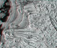
Oh, heck. I'm sure they won't mind if I post one or two ahead of time.  Here is one from Becquerel at 1/16th scale.
|
Posted by: CosmicRocker Dec 8 2008, 05:56 AM
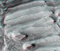
Here is another from Becquerel at 1/4th scale. It would be really nice if we could view anaglyphs in IAS Viewer.
|
tdemko: Thanks for that pacemaker link. You have got to imagine that this kind of research will play an important role in determining how our climate might be changing.
Posted by: imipak Dec 8 2008, 07:41 PM
Wow, those are great, thanks CR! What a happy coincidence that science and eye-candy turn up together. (Stepping gingerly around non-UMSF http://www.google.co.uk/search?q=mars%20site%3Arealclimate.org)... any idea what sort of vertical relief we're looking here? How tall is that spectacular spire half-way down the right-hand side of your second anaglyph, I wonder?
Posted by: jekbradbury Dec 8 2008, 10:41 PM
The HiRISE website has an amazing http://www.uahirise.org/media/clips/periodic-layering-becquerel.mov of Becquerel available.
Posted by: CosmicRocker Dec 10 2008, 04:00 AM
That flyover was outstanding.
The http://hirise.lpl.arizona.edu/e has published a gallery of 362 anaglyphs of Mars' surface. They have full resolution JPEG2000 images and lower res PNGs. Best of all, like the regular imagery these can be viewed with IAS viewer.
Here's the direct link to http://hirise.lpl.arizona.edu/anaglyph/singula.php?ID=PSP_001955_2015.
Posted by: MouseOnMars Feb 1 2009, 07:31 PM
So, if I've grasped this correctly, every layer we see in those images is a warm to ice age swing happening over ten's of thousands of years ?
Posted by: tty Feb 1 2009, 09:37 PM

Essentially yes, and as a matter of fact the same thing can be seen here on Earth, for example in Pleistocene Loess beds in Central Europe and Northern China, or Triassic lake sediments in New Jersey. However Earth is a much more dynamic planet than Mars, so it is very rare to find very long sequences or such beautiful exposures.
Posted by: rlorenz Feb 2 2009, 01:47 AM
Err, a better term is Croll-Milankovic cycles. The Scot, James Croll, really figured the whole thing out earlier
(he studied the boulder clays and other geological evidence for glaciation, calculated how much heat the
gulf stream transports and thus how much colder northern europe would be without it, and estimated
the climatic effect of orbit/spin changes.). He laid out the big picture. Milankovic just redid the
mathematics a little better.....
Powered by Invision Power Board (http://www.invisionboard.com)
© Invision Power Services (http://www.invisionpower.com)