LROC news and images |

  |
LROC news and images |
 Aug 29 2009, 03:39 AM Aug 29 2009, 03:39 AM
Post
#166
|
|
|
Senior Member  Group: Members Posts: 2517 Joined: 13-September 05 Member No.: 497 |
QUOTE (2amazing @ Aug 28 2009, 04:54 PM)  Does someone know how the code is build off ? I think he was asking about the naming convention. See http://geo.pds.nasa.gov/missions/lro/docs/...lroc_av_sis.pdf Individual EDR files will follow the naming convention: [TARGET][MET][INSTRUMENT][PRODUCT].img Where [TARGET] is a single character denoting the observation target [(M)oon, (E)arth, ( C ) alibration or (S)tar]; [MET] is a nine digit number reflecting the Mission Elapsed Time of acquisition (with a single digit for partition which denotes a reset of the MET); [INSTRUMENT] is a single character denoting the instrument, e.g. ( R )ight NAC, (L)eft NAC, (M)onochrome WAC, ( C)olor WAC, (V)is WAC, or (U)v WAC; and [PRODUCT] is a single character to denote (E)dr. -------------------- Disclaimer: This post is based on public information only. Any opinions are my own.
|
 |
 
|
|
Aug 29 2009, 02:03 PM
Post
#167
|
||
|
Solar System Cartographer Group: Members Posts: 10162 Joined: 5-April 05 From: Canada Member No.: 227 |
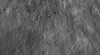
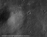
The new image 2amazing mentioned is now on the LROC browse page. It's in Balmer, a big smooth-plains-floored basin near the limb, and one of the Constellation priority targets.
http://wms.lroc.asu.edu/lroc_browse Here's a crop... ejecta blocks south of the fresh crater. Some of them hit the ground with enough horizontal velocity to roll away from the crater - these are the first boulder tracks I've ever seen away from steep slopes (Hey James!)
Phil -------------------- ... because the Solar System ain't gonna map itself.
Also to be found posting similar content on https://mastodon.social/@PhilStooke Maps for download (free PD: https://upload.wikimedia.org/wikipedia/comm...Cartography.pdf NOTE: everything created by me which I post on UMSF is considered to be in the public domain (NOT CC, public domain) |
|
|
|
|
|
|
Aug 29 2009, 02:29 PM
Post
#168
|
|
 Member Group: Members Posts: 753 Joined: 23-October 04 From: Greensboro, NC USA Member No.: 103 |
There's a nice image at the Lunar Orbiter Image Recovery Project site comparing a Lunar Orbiter III high-res shot of the Apollo 14 landing site with the latest LROC image. It's very easy to see the changes imparted to the site from Apollo 14!
Comparison of Lunar Orbiter III and LROC image of Apollo 14 site -------------------- Jonathan Ward
Manning the LCC at http://www.apollolaunchcontrol.com |
|
|
|
|
Aug 29 2009, 02:32 PM
Post
#169
|
|
|
Newbie Group: Members Posts: 12 Joined: 24-August 09 Member No.: 4911 |
M104061987RE.tif
M=moon 104061987 = time in minutes? How can you calculate whitch time/date this picture was taken. |
|
|
|
|
Aug 29 2009, 02:55 PM
Post
#170
|
|
|
Solar System Cartographer Group: Members Posts: 10162 Joined: 5-April 05 From: Canada Member No.: 227 |
The 104th of June, 1987?
More likely it's a count of seconds since some time which is probably specified somewhere in the documentation. But I prefer the idea that it's the 104th of June. Phil -------------------- ... because the Solar System ain't gonna map itself.
Also to be found posting similar content on https://mastodon.social/@PhilStooke Maps for download (free PD: https://upload.wikimedia.org/wikipedia/comm...Cartography.pdf NOTE: everything created by me which I post on UMSF is considered to be in the public domain (NOT CC, public domain) |
|
|
|
|
Aug 29 2009, 03:42 PM
Post
#171
|
|
|
Senior Member Group: Members Posts: 2920 Joined: 14-February 06 From: Very close to the Pyrénées Mountains (France) Member No.: 682 |
QUOTE (dvandorn @ Aug 28 2009, 12:22 AM) If I remember my high school French from 37 years ago, I believe it runs: ..... And the days of the week are: ..... Spelling could be atrociously wrong, of course...  -the other Doug nearly ok oDoug... Jeudi and not judi (so Jeudi is a mix of your judi and ...Jedi) Dimanche and not Demansche Juillet and not Julliet Août (I've got the right key board )and as Doug pointed out you've missed Mai (which is a Maymonth and not a Mayday...sorry I couldn't resist) ...and I don't want to hear your spelling  -------------------- |
|
|
|
|
Aug 29 2009, 04:03 PM
Post
#172
|
|
 Administrator Group: Admin Posts: 5172 Joined: 4-August 05 From: Pasadena, CA, USA, Earth Member No.: 454 |
It's certainly counting up in seconds. I usually just make an Excel spreadsheet that takes the time quoted on an official release and the MET and then set up a formula that can calculate the date for any MET. But for LROC it doesn't really seem to be necessary, since they're putting the UTC time on all the Zoomify images. For instance this one which we're told is from Tue Aug 04 14:51:59 UTC 2009. Taking the whole nine-digit number as the date, it counts up from April 18, 2006, but I think it's more likely that the first digit isn't part of the counter, so it counts up from June 18 at 14:32:12. This was exactly 7 hours before launch. Maybe that was when they booted the spacecraft computer?
--Emily -------------------- My website - My Patreon - @elakdawalla on Twitter - Please support unmannedspaceflight.com by donating here.
|
|
|
|
|
Aug 29 2009, 06:49 PM
Post
#173
|
|
|
Senior Member Group: Members Posts: 2517 Joined: 13-September 05 Member No.: 497 |
QUOTE (elakdawalla @ Aug 29 2009, 09:03 AM) This was exactly 7 hours before launch. Sounds like the difference between UT and MST where the LROC operations center is. Maybe some time system confusion there. Presumably somewhere they have documented the definition of MET 0 in UT (or better, ET.) I'm a little surprised they used MET; we usually use some arbitrary time like 0 Ephemeris Time ("epoch of J2000"). The first digit is probably what they meant by "a single digit for partition which denotes a reset of the MET". I've seen clearer pieces of PDS documentation -------------------- Disclaimer: This post is based on public information only. Any opinions are my own.
|
|
|
|
|
Aug 29 2009, 06:56 PM
Post
#174
|
|
|
Newbie Group: Members Posts: 12 Joined: 24-August 09 Member No.: 4911 |
Hai Emily
Not every file and images match this methode. Sometimes the date is not correct or time See excel attachment.
Attached File(s)
|
|
|
|
|
Aug 29 2009, 07:38 PM
Post
#175
|
|
|
Senior Member Group: Members Posts: 2517 Joined: 13-September 05 Member No.: 497 |
QUOTE (2amazing @ Aug 29 2009, 11:56 AM) Not every file and images match this methode. The "nacl" and "nacr" files use the convention that the LROC hardware uses, where are images have an arbitrary 32-bit ID, reported in the file names as 8 hex digits. You can't glean anything more from these filenames without having access to the commands. Obviously the PDS releases will be cleaned up and conform to the EDR documentation; it seems these public releases are using various naming conventions. (I'm just speculating, I have nothing to do with this stuff.) -------------------- Disclaimer: This post is based on public information only. Any opinions are my own.
|
|
|
|
| Guest_Zvezdichko_* |
Aug 30 2009, 06:42 PM
Post
#176
|
||
|
Guests |
I played with the images a little and did some basic editing, basically (but not limited to) reducing noise, sharpening and increasing contrast. Not as good as you can do it, but at least I tried. Imageshack and GIMP tricks.
Edit : Second photo
Attached thumbnail(s)
|
||
|
|
|
||
|
Aug 31 2009, 06:55 AM
Post
#177
|
|
|
Newbie Group: Members Posts: 12 Joined: 24-August 09 Member No.: 4911 |
Answer by e-mail from webmaster http://lroc.sese.asu.edu 30/08/09 11:27 PM
QUOTE The value after the M is the mission elapsed time of the observation. The second to last character in the name denotes the observation type (L = left NAC, R = right NAC, C = 7-band WAC, M = 1 band WAC, V = VIS-only WAC, U = UV-only WAC). The last character denotes the type of PDS product (E = EDR, C = CDR). |
|
|
|
|
Aug 31 2009, 02:10 PM
Post
#178
|
|
|
Senior Member Group: Members Posts: 2517 Joined: 13-September 05 Member No.: 497 |
QUOTE (2amazing @ Aug 30 2009, 10:55 PM) Answer by e-mail from webmaster ... More or less the exact same thing I said in post 166, no? -------------------- Disclaimer: This post is based on public information only. Any opinions are my own.
|
|
|
|
|
Aug 31 2009, 06:35 PM
Post
#179
|
|
|
Newbie Group: Members Posts: 12 Joined: 24-August 09 Member No.: 4911 |
QUOTE (mcaplinger @ Aug 31 2009, 04:10 PM) More or less the exact same thing I said in post 166, no? Yep 
|
|
|
|
|
Sep 1 2009, 08:23 PM
Post
#180
|
|||
|
Junior Member Group: Members Posts: 62 Joined: 30-July 09 Member No.: 4887 |
QUOTE (Phil Stooke @ Aug 29 2009, 02:03 PM) The new image 2amazing mentioned is now on the LROC browse page. It's in Balmer, a big smooth-plains-floored basin near the limb, and one of the Constellation priority targets. http://wms.lroc.asu.edu/lroc_browse Here's a crop... ejecta blocks south of the fresh crater. Some of them hit the ground with enough horizontal velocity to roll away from the crater - these are the first boulder tracks I've ever seen away from steep slopes (Hey James!)
Phil Yes, this one has alot of boulder tracks. Qualitatively, it is interesting how thin the dust layer is as evident of the difference between the width of some boulders and narrowness of their track. How deep is the soft stuff supposed to be?
|
||
|
|
|
||
|

|
Lo-Fi Version | Time is now: 16th May 2024 - 05:54 PM |
|
RULES AND GUIDELINES Please read the Forum Rules and Guidelines before posting. IMAGE COPYRIGHT |
OPINIONS AND MODERATION Opinions expressed on UnmannedSpaceflight.com are those of the individual posters and do not necessarily reflect the opinions of UnmannedSpaceflight.com or The Planetary Society. The all-volunteer UnmannedSpaceflight.com moderation team is wholly independent of The Planetary Society. The Planetary Society has no influence over decisions made by the UnmannedSpaceflight.com moderators. |
SUPPORT THE FORUM Unmannedspaceflight.com is funded by the Planetary Society. Please consider supporting our work and many other projects by donating to the Society or becoming a member. |
|