Cape York - The "Lakelands", Starting sol 2703 |

  |
Cape York - The "Lakelands", Starting sol 2703 |
 Sep 22 2011, 09:19 AM Sep 22 2011, 09:19 AM
Post
#136
|
|
|
Senior Member  Group: Members Posts: 2998 Joined: 30-October 04 Member No.: 105 |
Good points, Tom.
I think we are seeing glasses (impact melts) here-- we certainly see impact breccias with many angular clasts that have a vitreous appearance. If not from Endeavour, then from any of the several other impacts evident in the area. We don't see that many Precambrian glasses here on Earth. But PC rocks here have been buried, metamorphosed, tectonicizated and generally weathered in a warm and wet oxidizing environment. On Mars, they've been in dry storage for megamillenia (by comparison), so I think that a glass would stay glassy much longer. But this is the first example we've been of the type, so who knows... Google in usually your friend, but in this case was a tangle of ambiguity. Most of the hits for "perlite" were for the garden soil additive with loose pointers towards the volcanic glass mineral. And I've not seen my copy of Dana for decades... What was the source of that "perlite" photo you showed? I tried to back my way out through the "bigcache.googleapis.com" URL but I got 404'd. Nice new Pancams of site "Chester Lake2" this AM, and the tracking web suggests more MI's upcoming with soem APXS work. Then, I've heard, Oppy'll be moving on by the weekend. These are interesting times... --Bill -------------------- |
 |
 
|
|
Sep 22 2011, 10:02 AM
Post
#137
|
||
|
Senior Member Group: Members Posts: 2820 Joined: 22-April 05 From: Ridderkerk, Netherlands Member No.: 353 |
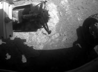
Sol 2722 Front Hazcam.
The RAT is still working.  Jan van Driel
|
|
|
|
|
|
|
Sep 22 2011, 01:14 PM
Post
#138
|
|
 Senior Member Group: Members Posts: 2173 Joined: 28-December 04 From: Florida, USA Member No.: 132 |
QUOTE (Bill Harris @ Sep 22 2011, 04:19 AM)  ...Google in usually your friend... It can still be your friend if you Google "perlite ore".Here's one concise description from a company whose claim to fame is owning both ore mining and processing facilities: "Perlite Ore is formed by magmatic ("liquid rock") processes, usually in "domes",that over geologic time periods entrap water into the Perlite matrix. The mechanism through which this occurs is not completely understood, however, it is this entrapped water which gives perlite ore it's unique ability to "Pop" under proper high temperature conditions." |
|
|
|
|
Sep 22 2011, 10:10 PM
Post
#139
|
|
 Senior Member Group: Moderator Posts: 2262 Joined: 9-February 04 From: Melbourne - Oz Member No.: 16 |
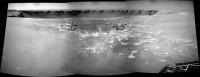
As there are still missing data I haven't tried too hard to perfect this, but the the view is so astounding that I can't keep this preliminary version to myself!
  James -------------------- |
|
|
|
|
Sep 22 2011, 10:34 PM
Post
#140
|
||
 The Poet Dude Group: Moderator Posts: 5551 Joined: 15-March 04 From: Kendal, Cumbria, UK Member No.: 60 |
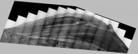
Absolutely gorgeous James! I've been trying to make the same view but can't get the ends to behave, or the colours to all blend, so I've gone with the central section and trying to bring out subtle shades and features in the central dome...
-------------------- |
|
|
|
|
|
|
Sep 22 2011, 11:37 PM
Post
#141
|
|
|
Solar System Cartographer Group: Members Posts: 10151 Joined: 5-April 05 From: Canada Member No.: 227 |
Both are spectacular! Thanks.
Phil -------------------- ... because the Solar System ain't gonna map itself.
Also to be found posting similar content on https://mastodon.social/@PhilStooke Maps for download (free PD: https://upload.wikimedia.org/wikipedia/comm...Cartography.pdf NOTE: everything created by me which I post on UMSF is considered to be in the public domain (NOT CC, public domain) |
|
|
|
|
Sep 23 2011, 12:21 AM
Post
#142
|
|
 Member Group: Members Posts: 754 Joined: 9-February 07 Member No.: 1700 |
wowie! What a spectacular view.
Q- do we see haze in the distance? It looks so much like the San Fernando Valley, my brain computes an earth analog :-) Apologies if this has already been discussed, I searched for "haze" in this topic and the Cape York thread. |
|
|
|
|
Sep 23 2011, 06:35 AM
Post
#143
|
|
 Senior Member Group: Members Posts: 2228 Joined: 1-December 04 From: Marble Falls, Texas, USA Member No.: 116 |
QUOTE (Bill Harris @ Sep 22 2011, 04:19 AM) ... What was the source of that "perlite" photo you showed? ... I did an image search for "perlite obsidian" and found some photos of obsidian in perlite. That image I linked to came from this guy's Panoramio album. -------------------- ...Tom
I'm not a Space Fan, I'm a Space Exploration Enthusiast. |
|
|
|
|
Sep 23 2011, 11:01 AM
Post
#144
|
|
|
Senior Member Group: Members Posts: 2998 Joined: 30-October 04 Member No.: 105 |
Ah, good search. Being an imprecise name, I didn't use "perlite" with "obsidian" in the same search term.
Did dig up a couple of references via the image search: The hydration and alteration of perlite and rhyolite http://jgs.lyellcollection.org/content/166/5/895.abstract and  --Bill -------------------- |
|
|
|
|
Sep 23 2011, 01:14 PM
Post
#145
|
|
|
Newbie Group: Members Posts: 7 Joined: 19-July 05 Member No.: 444 |
I don't know a thing how you all get the pictures and "driving data" from (I think) exploritorium. But, is there a way to see the results of the APXS that we're doing on Chester Lake from that data? Be great to know what the results of the Zinc levels and discuss it here.
|
|
|
|
|
Sep 23 2011, 02:11 PM
Post
#146
|
|
|
Solar System Cartographer Group: Members Posts: 10151 Joined: 5-April 05 From: Canada Member No.: 227 |
No, sorry! You have to wait for the APXS team to announce something.
Phil -------------------- ... because the Solar System ain't gonna map itself.
Also to be found posting similar content on https://mastodon.social/@PhilStooke Maps for download (free PD: https://upload.wikimedia.org/wikipedia/comm...Cartography.pdf NOTE: everything created by me which I post on UMSF is considered to be in the public domain (NOT CC, public domain) |
|
|
|
|
Sep 23 2011, 02:31 PM
Post
#147
|
|
 Senior Member Group: Members Posts: 4246 Joined: 17-January 05 Member No.: 152 |
APXS = real science! There's no way the team would release the important stuff like that before they had a chance to publish the results themselves.
The pictures have relatively little science value (at least it's unlikely anyone would scoop the team and publish something based on the pics alone). That's why we get to see the pictures in real time. QUOTE (brellis @ Sep 23 2011, 01:21 AM) Q- do we see haze in the distance? Absolutely - actually it's dust hanging in the air. But it's been slowly improving as we head into winter. Check this post.
|
|
|
|
|
Sep 23 2011, 04:34 PM
Post
#148
|
|
 Administrator Group: Admin Posts: 5172 Joined: 4-August 05 From: Pasadena, CA, USA, Earth Member No.: 454 |
QUOTE (fredk @ Sep 23 2011, 06:31 AM) The pictures have relatively little science value I think Jim Bell would beg to differ, as would most of the geologists on the team  However it's true that pictures alone rarely form the basis of a scientific paper. In any case the scientific value of the pictures is degraded by them being piped to the Web without calibration, auto-stretched, and JPEG-compressed, and one would be an idiot to write a scientific paper based on these raw JPEGs. Although I don't know for certain, I'd hazard a guess that uncalibrated APXS data would be uninterpretable. However it's true that pictures alone rarely form the basis of a scientific paper. In any case the scientific value of the pictures is degraded by them being piped to the Web without calibration, auto-stretched, and JPEG-compressed, and one would be an idiot to write a scientific paper based on these raw JPEGs. Although I don't know for certain, I'd hazard a guess that uncalibrated APXS data would be uninterpretable.-------------------- My website - My Patreon - @elakdawalla on Twitter - Please support unmannedspaceflight.com by donating here.
|
|
|
|
|
Sep 23 2011, 11:31 PM
Post
#149
|
|
|
Senior Member Group: Members Posts: 1043 Joined: 17-February 09 Member No.: 4605 |
True. It would be next to impossible to identify mineral makeup from pancam using the raw images from the web over only 11 wavelengths. Deconvolving spectra would be a huge challenge and would require data not available such as the CCD and electronics temperatures when the image was taken to enable proper calibration. The calibration target chips included hematite and goethite powder and were conditioned with UV exposure before launch, but after all this time could well have suffered from UV deterioration. I would assume that Jim Bell would have ensured laboratory spectra from expected minerals /combinations over expected temperature ranges using the actual deployed pancam to provide comnparative baselines. Certainly out of the amateur league.
But the Pancam and MI provide a huge amount of visual data and it is the correlation of all data that enables the production of the absolutely outstanding science papers we have become used to. |
|
|
|
|
Sep 25 2011, 05:24 PM
Post
#150
|
|||
|
The Poet Dude Group: Moderator Posts: 5551 Joined: 15-March 04 From: Kendal, Cumbria, UK Member No.: 60 |
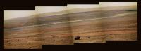
Three years ago today (if I've read the dates right), on sol 1661, Oppy paused in her trek around the edge of Victoria Crater, stopping just in front of a small crater called "Sputnik", and we all marvelled at the incredible vista before her: the great crater's capes and bays stretched away on all sides, its crumbling cliffs and dust-rippled floor all fighting for our attention. Oppy sent back three pictures of "Sputnik" which, when joined together, looked like this...
On the far horizon were a few barely-there bumps - the hills marking the rim of a huge crater called "Endeavour", an enormous hole in the ground that was so far away that even thinking of trying to drive to it was foolish; such a journey would take years, years, and require the rover - which had already exceded all expectations - to cross a vast area of unforgiving desert. Oppy wouldn't get even halfway, surely... Three years later...

-------------------- |
||
|
|
|
||
|

|
Lo-Fi Version | Time is now: 26th April 2024 - 05:41 PM |
|
RULES AND GUIDELINES Please read the Forum Rules and Guidelines before posting. IMAGE COPYRIGHT |
OPINIONS AND MODERATION Opinions expressed on UnmannedSpaceflight.com are those of the individual posters and do not necessarily reflect the opinions of UnmannedSpaceflight.com or The Planetary Society. The all-volunteer UnmannedSpaceflight.com moderation team is wholly independent of The Planetary Society. The Planetary Society has no influence over decisions made by the UnmannedSpaceflight.com moderators. |
SUPPORT THE FORUM Unmannedspaceflight.com is funded by the Planetary Society. Please consider supporting our work and many other projects by donating to the Society or becoming a member. |
|