How can I remove banding effect from .cub file Magellan Venus |

  |
How can I remove banding effect from .cub file Magellan Venus |
 Feb 2 2016, 07:58 AM Feb 2 2016, 07:58 AM
Post
#1
|
||
|
Junior Member  Group: Members Posts: 91 Joined: 21-August 06 Member No.: 1063 |
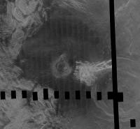
I have this .cub file of a section of Venus taken by Magellan that I got from map-a-planet2. Picture included below. You can see the striping effect. Does anyone know of a way to remove this banding effect easily in ISIS3 or another tool?
The best answer I have to far is using "Equalizer" in ISIS3 https://isis.astrogeology.usgs.gov/Applicat.../equalizer.html Problem though is it looks like you have to fix it using the original striped input images before they are assembled into a .cub. All I have though is the .cub that was already mosaicked. Any suggestions on how to remove the striped effect at this point? I dont believe those orginal individual striped images are avaible to public. All I know of is the 130 gb .cub file found on mapaplanet2 from which this image was taken from. thanks
Attached thumbnail(s)
|
|
 |
 
|
|
|
Feb 2 2016, 12:16 PM
Post
#2
|
|
 IMG to PNG GOD Group: Moderator Posts: 2250 Joined: 19-February 04 From: Near fire and ice Member No.: 38 |
dstripe in ISIS3 can remove striping but the problem is that the stripes have to be vertical or horizontal (maybe you could rotate the image before destriping?).
See https://isis.astrogeology.usgs.gov/Applicat...pe/dstripe.html |
|
|
|
|
Feb 2 2016, 02:53 PM
Post
#3
|
|
|
Senior Member Group: Members Posts: 2511 Joined: 13-September 05 Member No.: 497 |
QUOTE (ncc1701d @ Feb 1 2016, 11:58 PM)  I dont believe those orginal individual striped images are avaible to public. Sure they are. They're called Full Resolution Basic Image Data Records or F-BIDRs. See http://pds-geosciences.wustl.edu/missions/magellan/ Getting rid of shading at the boundaries of the swaths was extremely difficult because of radar artifacts. Maybe in the 20+ years since I've looked at Magellan data someone has improved the processing. -------------------- Disclaimer: This post is based on public information only. Any opinions are my own.
|
|
|
|
|
Feb 3 2016, 03:08 AM
Post
#4
|
|
|
Member Group: Members Posts: 890 Joined: 18-November 08 Member No.: 4489 |
if you want i just gave a copy of my 131072x65536 pixel de striped Venus map to the Mesa Arizona CC planetarium
from the C1 data set this will save you about 6 months or more of work the black and white is 8 Gig the color is 24 gig in isis3 cub format and georeferenced --  -- 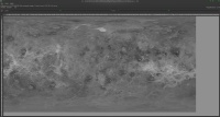 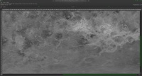 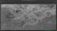 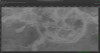 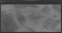 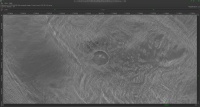 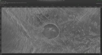 Dsrtipe is what i used after remapping to Mercator and rotating sections of the C1 data to vertical ( the strips are on a " s "curve ) for the missing "No-data" areas i inpainted using the Resynthesizer plugin for gimp combined with inpainting using the Greyc laboratories "Greystoration" tool QUOTE I dont believe those orginal individual striped images are avaible to public. yes they are the C1 is here http://pds-imaging.jpl.nasa.gov/data/mgn-v...5-midr-c1-v1.0/ the FULLRES "F-BIDR" http://pds-imaging.jpl.nasa.gov/data/mgn-v...-full-res-v1.0/ |
|
|
|
|
Feb 3 2016, 04:07 AM
Post
#5
|
|
|
Member Group: Members Posts: 890 Joined: 18-November 08 Member No.: 4489 |
an example from the C1
http://pds-imaging.jpl.nasa.gov/data/mgn-v...0n335/c1f12.img http://pds-imaging.jpl.nasa.gov/data/mgn-v...0n335/c1f12.lbl CODE pds2isis from=c1f12.lbl image=c1f12.img to=c1f12.cub use "qview's" tool measure for the angle -- 5.6 in this case CODE rotate from=c1f12.cub to=work.cub degrees=5.6 CODE dstripe from=work.cub to=work1.cub vlnl=137 vlns=3 vhnl=3 vhns=137 CODE rotate from=work1.cub to=c1f12A.cub degrees=-5.6 ( you will need to fix the mapping and extra border on the image after the second rotate 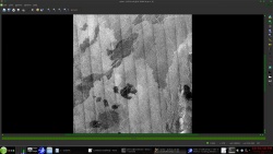 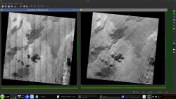 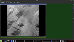
|
|
|
|
|
Feb 3 2016, 05:38 AM
Post
#6
|
|
 Lord Of The Uranian Rings Group: Members Posts: 798 Joined: 18-July 05 From: Plymouth, UK Member No.: 437 |
That's amazing, John. Somewhat on a tangent, could these techniques be utilized to clean-up the USGS Titan radar mosaic, as seen here:
http://astrogeology.usgs.gov/search/detail...n180_128ppd/cub Furthermore, as someone who doesn't have access to ISIS, would the CUB file preserve the SAR swathes in separate layers? -------------------- |
|
|
|
|
Feb 3 2016, 06:38 AM
Post
#7
|
|
|
Member Group: Members Posts: 890 Joined: 18-November 08 Member No.: 4489 |
ian
for that cub ?? no if you work with each of the radar passes and mosaic then one at a time ?? then maybe ?? but "noseam" would be a better tool back on target for the thread The dstripe tool works best on very regular noise and for it's intended use -- see the images here https://isis.astrogeology.usgs.gov/Applicat...pe/dstripe.html |
|
|
|
|
Feb 3 2016, 08:05 PM
Post
#8
|
|
|
Senior Member Group: Members Posts: 2511 Joined: 13-September 05 Member No.: 497 |
Given how well this worked, I'm surprised no one has gone back and reprocessed the whole C1-MIDR dataset like this. There's this -- http://www.celestiamotherlode.net/catalog/...p?addon_id=1070 -- but I haven't looked at it.
-------------------- Disclaimer: This post is based on public information only. Any opinions are my own.
|
|
|
|
|
Feb 3 2016, 08:49 PM
Post
#9
|
|
|
Member Group: Members Posts: 890 Joined: 18-November 08 Member No.: 4489 |
mcaplinger
that IS my map on the Celestia motherload ( libido also ask me not to host any more 12+ gig files ) in 2011 / 2012 over the winter i reworked the C1 data |
|
|
|
|
Feb 3 2016, 10:27 PM
Post
#10
|
|
|
Senior Member Group: Members Posts: 2511 Joined: 13-September 05 Member No.: 497 |
QUOTE (JohnVV @ Feb 3 2016, 12:49 PM) in 2011 / 2012 over the winter i reworked the C1 data Is the georeferenced CUB version online anywhere? Maybe USGS should be using that since it's so much better than the original version. -------------------- Disclaimer: This post is based on public information only. Any opinions are my own.
|
|
|
|
|
Feb 4 2016, 12:48 AM
Post
#11
|
|
|
Member Group: Members Posts: 890 Joined: 18-November 08 Member No.: 4489 |
my large map is here:
-- do to age the below links do not work if someone needs it PM me https://drive.google.com/file/d/0B6ZYAd08tZ...iew?usp=sharing and https://drive.google.com/open?id=0B6ZYAd08t...SXpvS1V1T3R5bDg this 4.91 gig zip ( would be smaller if i used xz archive) unzips to a 8 gig , 1 band isis3 cub file 131072 x 65536 pixels this is the header CODE Object = IsisCube
Object = Core StartByte = 65537 Format = Tile TileSamples = 2048 TileLines = 2048 Group = Dimensions Samples = 131072 Lines = 65536 Bands = 1 End_Group Group = Pixels Type = UnsignedByte ByteOrder = Lsb Base = 0.0 Multiplier = 1.0 End_Group End_Object Group = Mapping ProjectionName = SimpleCylindrical CenterLongitude = 0.0 <degrees> TargetName = Venus EquatorialRadius = 1737400.0 <meters> PolarRadius = 1737400.0 <meters> LatitudeType = Planetocentric LongitudeDirection = PositiveEast LongitudeDomain = 180 <degrees> MinimumLatitude = -90.0 <degrees> MaximumLatitude = 90.0 <degrees> MinimumLongitude = -180.0 <degrees> MaximumLongitude = 180.0 <degrees> UpperLeftCornerX = -5458203.0763469 <meters> UpperLeftCornerY = 2729101.5381735 <meters> PixelResolution = 83.285569402241 <meters> # PixelResolution = <meters/pixel> Scale = 364.088888889 <pixels/degree> End_Group End_Object Object = Label Bytes = 65536 End_Object Object = History Name = IsisCube StartByte = 8590000129 Bytes = 1748 End_Object End |
|
|
|
|

|
Lo-Fi Version | Time is now: 18th April 2024 - 03:28 AM |
|
RULES AND GUIDELINES Please read the Forum Rules and Guidelines before posting. IMAGE COPYRIGHT |
OPINIONS AND MODERATION Opinions expressed on UnmannedSpaceflight.com are those of the individual posters and do not necessarily reflect the opinions of UnmannedSpaceflight.com or The Planetary Society. The all-volunteer UnmannedSpaceflight.com moderation team is wholly independent of The Planetary Society. The Planetary Society has no influence over decisions made by the UnmannedSpaceflight.com moderators. |
SUPPORT THE FORUM Unmannedspaceflight.com is funded by the Planetary Society. Please consider supporting our work and many other projects by donating to the Society or becoming a member. |
|