Unmanned landing sites from LRO, Surveyors, Lunas, Lunakhods and impact craters from hardware impacts |

Unmanned landing sites from LRO, Surveyors, Lunas, Lunakhods and impact craters from hardware impacts |
 Sep 7 2009, 07:51 PM Sep 7 2009, 07:51 PM
Post
#1
|
|
 Senior Member  Group: Members Posts: 3419 Joined: 9-February 04 From: Minneapolis, MN, USA Member No.: 15 |
I figured it was time to begin a thread like this, especially since some of us may still be looking for the Surveyor III retro motor casing (assuming the bright dot to the north of the landing site isn't it).
We ought to be seeing some of the other Surveyors fairly soon, I would think. We know most of their locations pretty accurately. Again, I think there is a lot to be gained, both from scientific and engineering standpoints, from detailed imaging of the Surveyor VII landing site, just to mention one. And I really want to see how visible the Lunakhod tracks are as opposed to the MET and LRV tracks. So... until we begin to see images of other unmanned hardware (or the craters caused by same), we could always discuss comparisons of Surveyor III surface imagery to the new LROC images of its landing site here. I'm especially taken by how you can resolve many of the blocks in Block Crater in the LROC image, which gives you a good feel for the explosive nature of the ejecta and roughly where in the ejecta plume a given block might have come from. Might be interesting/useful to apply this information to the samples taken at that location.  -the other Doug -------------------- The trouble ain't that there is too many fools, but that the lightning ain't distributed right. -Mark Twain
|
 |
 
|
 |
| Guest_Zvezdichko_* |
Oct 1 2009, 08:46 AM
Post
#16
|
|
Guests |
QUOTE (JRA @ Oct 1 2009, 09:37 AM)  It looks as though the Surveyor 1 site has been imaged. The image was taken when the LRO was still in the commissioning orbit. http://lroc.sese.asu.edu/news/?archives/11...ar-landing.html Old http://www.unmannedspaceflight.com/index.p...st&p=147019 Anyway, good contribution |
|
|
|
|
Oct 1 2009, 10:43 AM
Post
#17
|
|
|
Newbie Group: Members Posts: 19 Joined: 17-June 09 Member No.: 4825 |
QUOTE (Zvezdichko @ Oct 1 2009, 12:46 AM) Oops, didn't realize it was posted already. My bad
|
|
|
|
|
Oct 1 2009, 11:15 AM
Post
#18
|
|
 The Poet Dude Group: Moderator Posts: 5551 Joined: 15-March 04 From: Kendal, Cumbria, UK Member No.: 60 |
Not a "bad" at all, don't worry about it JRA, it happens all the time
When I joined here I lost count of the number of times I alerted the board to something already mentioned by someone else. I prefer to think of it as "being keen to share", not "old".
-------------------- |
|
|
|
|
Oct 1 2009, 01:58 PM
Post
#19
|
||
|
Senior Member Group: Members Posts: 1074 Joined: 21-September 07 From: Québec, Canada Member No.: 3908 |
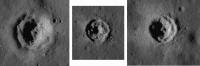
I noticed some funny-looking craters on LRO's image of the Surveyor 1 landing site. Below is a sampling.
These three craters are all at the same scale. They seem recent and are around 100 m wide or less. It looks like the unconsolidated regolith was pushed back by the blast produced by the impact, revealing the surface of the bedrock. If this interpretation is correct., these craters would make great sampling spots. No need to dig through the regolith to get to the bedrock, the work has already been done by meteorites.
Attached thumbnail(s)
|
|
|
|
|
|
|
Oct 1 2009, 03:04 PM
Post
#20
|
|
|
Member Group: Members Posts: 540 Joined: 17-November 05 From: Oklahoma Member No.: 557 |
Surveyor 1 happened to land in one of the geologically youngest spots on the moon. The regolith there is exceptionally thin, which means you will get a lot of young looking craters, and they will plow into thin soil.
|
|
|
|
|
Oct 1 2009, 03:15 PM
Post
#21
|
|
|
Solar System Cartographer Group: Members Posts: 10160 Joined: 5-April 05 From: Canada Member No.: 227 |
This type of crater was discovered in Lunar Orbiter images and recognized as a probe of the depth to bedrock. They can be used to map variations in regolith thickness. Apollo 12's backup landing site - a pinpoint landing spot in Apollo Site 5, was near a crater of this type.
Phil -------------------- ... because the Solar System ain't gonna map itself.
Also to be found posting similar content on https://mastodon.social/@PhilStooke Maps for download (free PD: https://upload.wikimedia.org/wikipedia/comm...Cartography.pdf NOTE: everything created by me which I post on UMSF is considered to be in the public domain (NOT CC, public domain) |
|
|
|
|
Oct 1 2009, 03:26 PM
Post
#22
|
|
|
Senior Member Group: Members Posts: 1074 Joined: 21-September 07 From: Québec, Canada Member No.: 3908 |
Well, so I didn't discover anything new, but anyway, these craters are cool, especially at such high definition.
|
|
|
|
|
Oct 1 2009, 09:17 PM
Post
#23
|
|
|
Member Group: Members Posts: 252 Joined: 5-May 05 From: Mississippi (USA) Member No.: 379 |
QUOTE (charborob @ Oct 1 2009, 10:26 AM) Well, so I didn't discover anything new, But I learned something new. Jack |
|
|
|
|
Oct 2 2009, 02:48 AM
Post
#24
|
||
|
Member Group: Members Posts: 808 Joined: 10-October 06 From: Maynard Mass USA Member No.: 1241 |
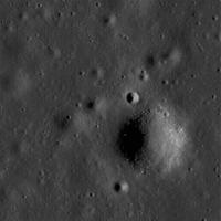
Here is the Surveyor 1 site
I downloaded the TIFF (!pain!) and then adjusted the dynamic levels, cropped, destriped, and a little blow up (whew!) (Dear LROC Team, please put non-annotated images up for us noodles to noodle with....like the Apollo sites!)
Cheers -------------------- CLA CLL
|
|
|
|
|
|
|
Nov 22 2009, 04:55 PM
Post
#25
|
|
|
Newbie Group: Members Posts: 2 Joined: 13-November 09 From: Brazil Member No.: 5042 |
LRO is now orbiting over Mare Crisium and the Sun is low over there.I hope it's imaging Luna 23 and 24 landing sites.
|
|
|
|
|
Mar 1 2010, 01:26 AM
Post
#26
|
|
|
Solar System Cartographer Group: Members Posts: 10160 Joined: 5-April 05 From: Canada Member No.: 227 |
LROC news from LPSC - heard from a thoroughly disreputable source (I'm only kidding, L!) - LROC has seen Luna 24 and Lunokhod 2. Results should be shown in a talk tomorrow. Maybe there will be a release soon after. Luna 24 apparently landed on a crater rim, which may have affected its sampling ability.
Phil -------------------- ... because the Solar System ain't gonna map itself.
Also to be found posting similar content on https://mastodon.social/@PhilStooke Maps for download (free PD: https://upload.wikimedia.org/wikipedia/comm...Cartography.pdf NOTE: everything created by me which I post on UMSF is considered to be in the public domain (NOT CC, public domain) |
|
|
|
|
Mar 1 2010, 01:38 AM
Post
#27
|
|
 Member Group: Members Posts: 236 Joined: 5-June 08 From: Udon Thani Member No.: 4185 |
QUOTE (Phil Stooke @ Mar 1 2010, 08:26 AM) Luna 24 apparently landed on a crater rim, which may have affected its sampling ability. That's great news Phil! Have been looking forward to those images for some time. Are they sure it's Luna 24 and not Luna 23 (which landed nearby), 23 was the one which damaged its drilling equipment on touchdown. |
|
|
|
|
Mar 1 2010, 01:45 AM
Post
#28
|
|
|
Solar System Cartographer Group: Members Posts: 10160 Joined: 5-April 05 From: Canada Member No.: 227 |
I can't tell you yet. Maybe more tomorrow.
Phil -------------------- ... because the Solar System ain't gonna map itself.
Also to be found posting similar content on https://mastodon.social/@PhilStooke Maps for download (free PD: https://upload.wikimedia.org/wikipedia/comm...Cartography.pdf NOTE: everything created by me which I post on UMSF is considered to be in the public domain (NOT CC, public domain) |
|
|
|
|
Mar 1 2010, 07:44 PM
Post
#29
|
|
|
Solar System Cartographer Group: Members Posts: 10160 Joined: 5-April 05 From: Canada Member No.: 227 |
Update. Mark Robinson showed images of three Luna landers, 20, 23 and 24. Luna 20 shows the shadow of its sample delivery arm "as if it's waving at us" according to Mark. Luna 23 is sitting on the very edge of a crater only 2 or 3 m across. No obvious sign of why it couldn't collect a sample. Luna 24 is on the rim of a c. 20 or 30 m fresh crater, which may explain an odd thing about its sample... not the amount, but the fact that it differed from the surrounding area as measured by remote sensing... it seems to consist of freshly exposed subsurface material rather than the space-weathered material all around it.
Beautiful pics - let's hope they are released very soon. Phil -------------------- ... because the Solar System ain't gonna map itself.
Also to be found posting similar content on https://mastodon.social/@PhilStooke Maps for download (free PD: https://upload.wikimedia.org/wikipedia/comm...Cartography.pdf NOTE: everything created by me which I post on UMSF is considered to be in the public domain (NOT CC, public domain) |
|
|
|
|
Mar 2 2010, 06:40 AM
Post
#30
|
|
 Senior Member Group: Members Posts: 1729 Joined: 3-August 06 From: 43° 35' 53" N 1° 26' 35" E Member No.: 1004 |
No release yet of the Luna images (too bad, where are they?!?)
in their place, this image of the Marius Hills Hole has been published on the LROC image browser http://wms.lroc.asu.edu/lroc_browse/view/M114328462R |
|
|
|
 |

|
Lo-Fi Version | Time is now: 11th May 2024 - 07:05 PM |
|
RULES AND GUIDELINES Please read the Forum Rules and Guidelines before posting. IMAGE COPYRIGHT |
OPINIONS AND MODERATION Opinions expressed on UnmannedSpaceflight.com are those of the individual posters and do not necessarily reflect the opinions of UnmannedSpaceflight.com or The Planetary Society. The all-volunteer UnmannedSpaceflight.com moderation team is wholly independent of The Planetary Society. The Planetary Society has no influence over decisions made by the UnmannedSpaceflight.com moderators. |
SUPPORT THE FORUM Unmannedspaceflight.com is funded by the Planetary Society. Please consider supporting our work and many other projects by donating to the Society or becoming a member. |
|