Printable Version of Topic
Click here to view this topic in its original format
Unmanned Spaceflight.com _ Titan _ T39 (December 20th 2007 / Rev 54)
Posted by: ngunn Dec 14 2007, 12:06 PM
The new 'looking ahead' with T39:
http://ciclops.org/view.php?id=4689
Posted by: alan Dec 14 2007, 05:12 PM
Someone have a polar map the path can be projected on?
Posted by: ngunn Dec 15 2007, 11:53 PM
Every time this comes up I'm cursing myself for not saving some easy link to the polar projections of the Titan map that Phil Stooke so helpfully provided while we were having a 'comparing polar regions' discussion some time ago. They're here somewhere, possibly in 'Titan's lakes revealed' but I'm not sure. If nobody else finds them I may have a hunt tomorrow. I think the last time I found them by searching all Phil's posts.
BTW any admin reading would be saving me perpetual embarassment if they would kindly correct my thread title. The next Titan flyby is on the 20th, not the 19th.
Posted by: scalbers Dec 16 2007, 12:16 AM
How about here?
http://www.unmannedspaceflight.com/index.php?showtopic=3168&st=90&p=93306&#entry93306
Posted by: MarcF Dec 16 2007, 01:04 AM
No radar SAR of Ontario Lacus itself ?
I'm sure I heard about something like that, but it seems not to be the case, at least not this time.
Marc.
Posted by: Mongo Dec 16 2007, 03:11 PM

I believe that http://www.unmannedspaceflight.com/index.php?act=attach&type=post&id=9798 is the image you are looking for.
Bill
Posted by: Decepticon Dec 16 2007, 10:03 PM
That Sar path is very close!
I can't wait to see the results.
Posted by: NMRguy Dec 16 2007, 10:30 PM
Ralph Lorenz said that Radar should get a look at Ontario during the XM in the "T38 (Dec 05, 2007)" thread. We'll have to wait until then, but the geometry should be more optimal in that flyby (I presume).
One of your ISS colleagues close to me was also among the chorus (including myself) that argued for T38 being used for ISS and VIMS to observe Ontario, it being a particularly good opportunity to do so. (Radar will hit it in XM, hopefully with both SAR and altimetry - the illumination will be poorer then, but we dont need no stinkin sunshine...).
Posted by: Del Palmer Dec 18 2007, 04:43 AM
The http://saturn.jpl.nasa.gov/multimedia/products/pdfs/20071220_titan_mission_description.pdf is now up.
Posted by: volcanopele Dec 21 2007, 08:42 PM
Here ye go. Please note that the path crosses several suspected lakes in the south polar region, including a W-Shaped lake and a few other very dark features in the region.
|
Posted by: rlorenz Dec 21 2007, 10:56 PM
"W-shaped Dark Feature" you mean..... RADAR will tell you if it is a lake or a dunefield....
btw - downlink isnt until this weekend and vacation may mean SAR doesnt get processed for
a while (to say nothing of the various PAO approvals required for web releases etc), so don't
assume there is some conspiracy afoot (or that Cassini blew up) just because images arent
out until the new year....
Posted by: volcanopele Dec 21 2007, 11:16 PM
har har, if that is a dune field, I owe you a beer.
Posted by: belleraphon1 Dec 22 2007, 12:21 AM
rlorenz...
understood..... space exploration takes patience. As a layman I have learned that in spades.
REALLY interested in this SAR. I think Titan's southern equinox occured in 1994?. Sunlight has been bathing the pole for almost 13 years. So are there lakes here at the south pole that have been filled by the summer solar intensity release of latent heat and monsoon downpours, while , in the north, the long dark spell has allowed the lakes to sit intact.
Is the equatorial region, in this epoch, always too warm for stable lakes?
Clumsy way of wanting to say, what role do the seasons play in the methanological cycle?
I thinks the onset of southern pole monsoons were captured in 1995 with a big cloud outburst.....
CASSINI needs XXM mission just to watch the seasonal play on this world.
Craig
Posted by: rlorenz Dec 22 2007, 02:06 PM
Posted by: David Dec 23 2007, 02:41 PM
out until the new year....
Of course there's a conspiracy -- a conspiracy to commit parochial, Earth-bound solstitial festivities. And that, of course, calls into question your loyalty to Titan. Let's see if you'll celebrate the Titanian solstice with as much commitment, comrade!

Posted by: belleraphon1 Dec 26 2007, 01:57 PM
rlorenz..
Thanks so much for the response.. I'll have to go back through the literature..... I had the impression the larger outbursts had been determined to be similar to the south pole clouds seen by CASSINI in 2004.
If the south pole clouds were methane cumulus clouds, wonder if the downpours made it to the surface?
I believe you have written on the physics of this, and that the air would become saturated enough to allow the drops to hit the surface. If that is the case, and these storms were a common summer time feature over the pole, what sort of erosion will we see at the surface?
Really wanna see this SAR!!!!
Craig
Posted by: Gladstoner Jan 4 2008, 08:44 AM
.
Posted by: volcanopele Jan 4 2008, 06:10 PM
I don't think you are imagining ALL of those apparent rivers. The thicker one flow south looks plenty real.
Posted by: nprev Jan 4 2008, 06:28 PM
Agreed...if I didn't know better, it almost looks like an estuary! Welcome, Gladstoner. 
Posted by: Juramike Jan 4 2008, 07:05 PM
Nice.
And if we got lucky, the swath hit the transition between the fractal lake morphology and the smooth shoreline morphology.
I can't wait 'till it gets released!
-Mike
Posted by: Matt Jan 4 2008, 10:07 PM
I share your eager anticipation, looks like the radar traversed a very interesting region.
Is that part of Mezzoramia at the far end of the swathe?
Posted by: volcanopele Jan 8 2008, 09:15 PM
Well, what do you know

http://photojournal.jpl.nasa.gov/jpeg/PIA10219.jpg
Posted by: volcanopele Jan 8 2008, 09:24 PM
Well, it's not a dune field, isn't an liquid-filled lake either...
http://photojournal.jpl.nasa.gov/catalog/PIA10218
Posted by: belleraphon1 Jan 8 2008, 10:23 PM
What Tha !!!!!!
Titan trumps us again....... but as I noted in post #16, the methane rain on these plains certainly tore up the terrain (erosion from the summer cloud bursts).
Craig
Posted by: djellison Jan 8 2008, 10:33 PM
Totally uninformed observers comment...
It looks just like the Severn Estuary - complete with the bow south of Gloucester.
http://maps.google.co.uk/?ie=UTF8&ll=51.792904,-2.375793&spn=0.297286,0.6427&t=k&z=11&om=1
Posted by: Sunspot Jan 8 2008, 11:08 PM
Some parts of the image look like the formations seen in some of the Salt Marshes in East Anglia.
Posted by: rlorenz Jan 8 2008, 11:10 PM
http://photojournal.jpl.nasa.gov/catalog/PIA10218
Sufficiently nondunelike to keep you out of owing me a beer, I guess.
The relative lack of lakes is intriguing, and rather contrary to the CICLOPS
propaganda put out before the encounter...
Posted by: Juramike Jan 8 2008, 11:20 PM
And check this out!
http://photojournal.jpl.nasa.gov/catalog/PIA10219
Look how the (wet muds?) display channels that look like sapping. And as you go further south in the image, the sapped channels get wider and wider, until they turn into narrowing ridges (wider valleys thus narrower ridges). Until only the thin ridges are left.
Just like a really cool Escher drawing.
Wow!
-Mike
Posted by: Olvegg Jan 8 2008, 11:36 PM
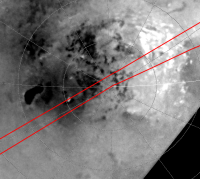
Approximate location:
|
Posted by: volcanopele Jan 8 2008, 11:39 PM
The relative lack of lakes is intriguing, and rather contrary to the CICLOPS
propaganda put out before the encounter...
But you still missed the two coolest lakes of all down there
But you did catch a few of our lakes.
Posted by: Sunspot Jan 8 2008, 11:52 PM
Why do so few flybys make uses of the radar? It seems it's the only instrument capable of making sense of what is generally happening on the surface. If I were on the RADAR science team I think i'd very frustrated at not being able to make more use of it.
Posted by: ugordan Jan 8 2008, 11:54 PM
I guess the ISS and VIMS folks would share the same feeling in their case...
Posted by: Sunspot Jan 9 2008, 12:04 AM
Certainly during flybys of other Moons whose surfaces are revealed in spectacular detail by the cameras - yes, But not at Titan.
Posted by: Juramike Jan 9 2008, 12:05 AM
Thanks Olvegg!
So the area in PIA10219 is the SW portion of Mezzoramia.
The cool wrinkle pattern is very similar to what that interesting area in T16 ('bout 2/3 of the way to the left in the swath). In that region, it looked like like the wrinkle area was between two plains. From the dendritic pattern (look on the margins, otherwise the eyes get all goofed up by the optical illusion, positive relief or negative relief - aaargh!) it appears to go from the the plain on the left (southern) down to the plain on the right (northern) in T16.
It will be entertaining to stare at this new image, looking for similarities and contrasts in that area of the T16 Swath, and the T7 Swath of northern Mezzoramia.
Why do the valleys and braided streambeds look so different in T7 compared to the southern Mezzoramia region?
Is the lowest area in T7 the equivalent to the southern plain of T16?
What makes the Escher channel/ridge terrain? Is it due to rainfall erosion, subsurface erosion, or "melting" (melting, chemical modification, or dissolution all could fal into this catchall) of a cohesive component of the material.
Is this material some sorta dried weak slurry material that erodes quickly? Like sand on a beach? Or what is it?
Is Titan nothing but a bunch of goopy sloughs and islands?
Wow! I'm really thankful that they released this so quickly!
-Mike
Posted by: Stu Jan 9 2008, 12:09 AM
Fascinating terrain... wow...

|
Posted by: Juramike Jan 9 2008, 06:01 AM
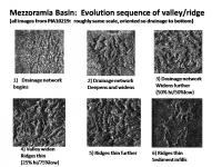
Here are some graphics I whipped up of the T39 RADAR Swath section shown in PIA10219.

|
The first graphic shows estimated drainage pattern based on dendritic pattern orientation. Broadly, it is pretty much to the N, towards the Mezzoramia basin. But along the swath there are several drainage basin divides almost like the surface shifted or dropped down into a series of puckers. Each pucker has its own little dendritic pattern. The broad patterns are indicate by the big blue arrows. The stream channels are indicated by red arrows. There is an orange area indicated that just doesnt seem to fit in more on this later.

|
The T39 Swath hit the SW section of Mezzoramia basin and the T7 Swath hit the N end of Mezzoramia basin. If the T7 Swath is turned upside down so that the drainage direction lines up, there are some similarities, as seen in the second graphic. One is that there are sediment filled puckers (or dropouts) like are seen in the T39 Swath. The only difference is that the puckers are filled with darker sediments in T7 and in the T39 swath they appear to have been subject to erosion so they have cute little dendritic patterns. Another similarity is that the RADAR bright sediment pattern near the basins appears simiar in the two swaths. This is seen in the following three slides:

|

|

|
The first slide shows the T7 bright pattern as one moves downstream near the basin (from left to right). The next two slides show similar patterns and are seen in the T39 Swath. The stream becomes bright on hitting the basin, then fans out and is criss-crossed by several dark lines. The RADAR brightness slowly fades on going further into the basin, possibly indicating sorting of materials over a very large distance. (Indicating extensive reworking?

|

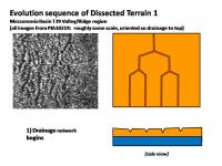
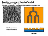
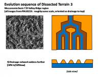
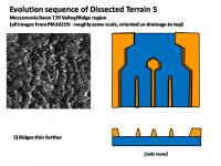
|
The T39 RADAR Swath image shows a nice spectrum of different valley/ridge widths. An evolutionary sequence is shown in the graphic above. It all starts with an easily erodible upland, which is down cut into a karst-like terrain (image 1 and 2). The valleys perhaps hit a harder layer (maybe the erodible stuff is organic shizzle and the hard layer is normal crust/clathrate?) and then begins to widen (image 3). As the valleys widen, the ridges become sharer and narrower. (images 4 and 5). In image 6, very thin ridges remain which have been partially buried in infilled material. The locations where these images were plucked from is shown in the second graphic.
So presumably the thicker the intervening highland, the younger and less eroded the surface. Or, the thinner the ridges and broader the valleys, the older the surface. Since the dropouts or puckers seem to have only gentle alluvial networks, they seem to not have been heavily eroded. Perhaps they are made of different materials or they are much younger.

|
The last slide shows a zoom of the area around the orange indicated feature. Across the surface, there appears to be a uniform graduation of valley/ridge networks going from thin intervening ridges towards the south to thicker ridges (less eroded) towards the N central part of the image. The one exception seems to be where the orange-bordered terrain loos like it recently dropped out and filled in, messing up the uniform pattern. And perhaps thats what happened. There was a slightly raised area that was subjected to erosion, then it suddenly collapsed and filled in. There does not appear to be any valley networks rushing into this new sinked area, although the bright line in radar indicates a substantial cliff. Other pucker areas seem to be located at drainage divides, thus the original surface prior to collapse must have been locally slightly higher. (Are these collapsed cryovolcano caldera??) This could be giving us a clue about the formation of at least the smooth type of lake, as well as some of the large dropout areas seen in W Xanadu, T7, and in the northern polar regions.
-Mike
Posted by: ngunn Jan 9 2008, 10:30 AM
I'm not sure I follow you in detail here, but I tentatively agree with your observation that this looks like different erosion forms cut through (at least two) different materials.
Posted by: ngunn Jan 9 2008, 11:52 AM
Sorry, couldn't resist:
'The rain on rough terrain drains mainly to the plain.'
'The rain on the plain flows mostly down the drain.'
Somebody stop me . . .
Posted by: Gladstoner Jan 9 2008, 12:51 PM
.
Posted by: Gladstoner Jan 9 2008, 01:20 PM
.
Posted by: belleraphon1 Jan 9 2008, 04:38 PM
'The rain on rough terrain drains mainly to the plain.'
'The rain on the plain flows mostly down the drain.'
Somebody stop me . . .
Actually ngunn, that sounds pretty abt!
Juramike... great work as usual.... all that schizzle and smurst and icy bedrock getting churned over the eons... no wonder the terrains on Titan are so diverse.
Sunspot.... we cannot understand the surface without knowing what the atmosphere is doing and what all that schizzle soup is made of... we need VIMS/ISS/INMS.... all the instruments, because this is a world....
Just SO thankful we have this wonderful CASSINI and all the folks involved in this mission..... and thankful this was released so quickly given the holidays....
Craig
Posted by: volcanopele Jan 9 2008, 06:38 PM
http://photojournal.jpl.nasa.gov/jpeg/PIA10219.jpg
I knew that river looked familiar: http://photojournal.jpl.nasa.gov/catalog/PIA06202
At least one of the little squiggles I drew actually turned out to be a river channel.
Posted by: ngunn Jan 9 2008, 08:03 PM
I note that the caption to the south pole image refers to the hypothesis that the north-south difference in lake numbers is a temporary seasonal phenomenon. While I liked that idea for a time I thought it had been ruled out because there is just not enough heat available to evaporate so much liquid in one seasonal cycle. Is the thinking on this changing again, or is the caption writer just making passing mention of an earlier idea?
To me it looks as if most of the drainage channels in the south polar 'highlands' specifically avoid the few lakes that seem to be present. In other words everything drains northward from a regional topographic high near the south pole - except for a few enclosed basins that can't drain, and therefore contain lakes. That makes sense if the poles are areas of net deposition of solids as suggested in the recent CHARM presentation. Is it then the great northern lakes that are the anomalies, since these require recent or ongoing downwarping of the crust on a regional scale to maintain their basins?
Posted by: DrShank Jan 11 2008, 03:07 AM
To me it looks as if most of the drainage channels in the south polar 'highlands' specifically avoid the few lakes that seem to be present. In other words everything drains northward from a regional topographic high near the south pole - except for a few enclosed basins that can't drain, and therefore contain lakes. That makes sense if the poles are areas of net deposition of solids as suggested in the recent CHARM presentation. Is it then the great northern lakes that are the anomalies, since these require recent or ongoing downwarping of the crust on a regional scale to maintain their basins?
Posted by: ngunn Jan 11 2008, 11:49 AM
And your comment, DrShank? I'm all ears.
Posted by: DrShank Jan 11 2008, 02:20 PM
yep, i goofed on this one during submission. i was looking for a planning map, which ugorgon graciously provided in another thread! sorry...
Posted by: ugordan Jan 11 2008, 02:23 PM
It was Exploitcorporations that dug up the map, not me. Don't want to take any false credit here...
Posted by: rlorenz Jan 11 2008, 04:14 PM
But you did catch a few of our lakes.
Would those the be two dark spots in your data that RADAR shows to be lakes, or
the dark spots that arent lakes? (Notably the arc near the pole)
It seems from the near-IR alone, you can't tell a lake from a hole in the ground....
re comment about more radar... sure it'd be nice, but Titan is a system (think Earth System
Science - Titan is just as complex). Maybe you'd map some more lakes, but you'd
then still be wondering what is in them (VIMS spectra?) and how they got there (INMS
formation of tholins) or whether the seasonal circulation changes in the stratosphere
(CIRS, radio occultations, ISS&VIMS images of the polar hood) bring the stuff down
preferentially at high latitude, etc. etc.
There is more to science than just pictures of the ground, though I acknowledge that may
the most readily interpretable sort of data.
Posted by: Juramike Feb 6 2008, 04:46 AM
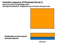
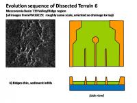
The area just south of the Mezzoramia Basin has been referred to as "Dissected Terrain" in an LPS abstract discussing the T39 RADAR Swath. (Stofan et al. LPS XXXIX (2008) Abstact 1491. "Varied Geologic Terrains at Titan's South Pole: First Results from T39". Freely available http://www.lpi.usra.edu/meetings/lpsc2008/pdf/1491.pdf.) The dissected terrain has mesas with flat valley floors in several areas. From the Abstract: "The rounded heads of the valleys indicate that sapping along with rainfall, has contributed to the formation of the drainages." So it would seem that the infiltration rate (ability of ground to suck up rainfall) is different between the Mountainous Terrain and the Dissected Terrain. The Dissected Terrain apparently being more porous.
It was postulated by Stofan et al. that erosion of flat lying layers could explain the appearance of the Dissected Terrain. If there was a significantly harder flat-lying layer at the base of softer material, natural stream meander would cut broader valleys and make the broad mesas thin to ridges over time. (Glacial action (material?) was also invoked as an erosion agent).
I put together a putative erosion sequence with examples of the Dissected Terrain S of Mezzoramia Basin showing initial downcutting through the softer material (in orange), followed by widening of the hydrocarbon stream to expose the harder layer (in blue). (Darker orange is meant to show the slope faces).
|
|
|
|
|

|
|
|
It is interesting to note that the cliff faces become steeper over time, rather than broadening out - this would indicate that removal of sediments at the base by stream meander is more important than erosion and cutting back of the cliff face by alluvial fan formation. Erosion is at the base, not at the top or sides of the mesa. This fits the hypothesis that this material easily absorbs rainfall on the top and slope of the mesa.
Eventually sediments may fill the different stages of the erosion sequence and partially bury the valley floors.
(And if anyone has the technology to put together an animated gif of this sequence, I'll bet it'll come out pretty cool-o.)
Now the Big Question: Does Dissected Terrain = Rotten Terrain + high rainfall?
-Mike
Posted by: Gladstoner Feb 6 2008, 12:38 PM
.
Posted by: titanicrivers Apr 27 2008, 05:47 AM
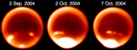
Is there SAR or other evidence of liquid in any of the streambeds on T39? Some of the short, radar dark channels may be methane springs and might be expected to have a steady supply of liquid from underground. I wonder if the meander coming in from the right side still has flow ...again its a bit radar dark. Also can we predict from the dissected terrain whether the rains come infrequently but fiercely as has been predicted from observations from ground based telescopes of Titan's S polar clouds? That huge cloudburst in Oct. 2004 must have moved some of that schizzle around a bit!
|
(Credit: H.G. Roe, Caltech)
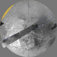
Posted by: peter59 Oct 7 2008, 09:52 PM
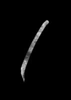
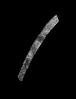
T39 RADAR Swath
|
|
Posted by: belleraphon1 Oct 9 2008, 01:08 AM
Found a feature in the southern T39 that looks very similar to the northern filled lake structure from T30. The T39 feature is at a tip of the Mezzoramia albedo feature.... but it looks shallower or drained... interesting...
http://www.flickr.com/photos/7323592@N07/2925028817/sizes/l/
Portion of the composite image above came from Jason Perry's Titan map of radar swaths...
http://pirlwww.lpl.arizona.edu/~perry/RADAR/
Check it out...
Craig
Posted by: belleraphon1 Oct 9 2008, 01:48 AM
The feature I note in my last post was included in this radar 'image' release back in January....
http://photojournal.jpl.nasa.gov/catalog/PIA10219
But it's association with the Mezzoramia albedo feature was not noted.
I am hoping we will hear more about this radar swath and the T41 Hotei at the coming DPS meeting next week.
Emily, on her blog regarding tomorrow's Enceladus encounter, has provided us a link to online webcasts of some of the sessions... http://dps08.astro.cornell.edu/AAS_WebcastSchedule_2008.html
Thanks Emily... this is Really Cool (know I am an UMSFer when I plan a weekend in front of my pc to hear planet-talk).
Hope to hear more about Enceladus as well...
Wonderful
Craig
Posted by: Olvegg Oct 9 2008, 05:31 PM
Yes, Mezzoramia is really very interesting region. I suppose it's dried up sea. Is it analogue of Kraken Sea or not, however, only future observations may answer.
Posted by: peter59 Oct 11 2008, 08:57 PM
Two additional T39 RADAR Swaths
|
and
|
Posted by: ngunn Oct 11 2008, 10:31 PM
Thanks for posting these bright enough to see. Other versins of T36 and 39 appear on my monitor so dark that I can hardly see their edges against the black background.
Posted by: peter59 Oct 12 2008, 07:34 AM
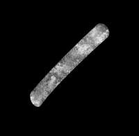
Another T39 RADAR Swath.
|
Powered by Invision Power Board (http://www.invisionboard.com)
© Invision Power Services (http://www.invisionpower.com)