Artemis 1 Cubesats, Ride-Along Robots |

Artemis 1 Cubesats, Ride-Along Robots |
 Aug 27 2022, 08:24 PM Aug 27 2022, 08:24 PM
Post
#1
|
|
|
Solar System Cartographer  Group: Members Posts: 10162 Joined: 5-April 05 From: Canada Member No.: 227 |
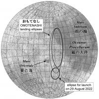
A new thread for a miniature (cubesat) moon lander. OMOTENASHI (a convoluted acronym which is also a Japanese word for 'selfless hospitality) is one of ten cubesats to be launched with Artemis 1, possibly as early as Monday, 29 August 2022 (two days away as i write rhis).
The lander has received little attention because it is really just a technology demonstrator of a method for getting very small objects safely to he lunar surface. Basically, let it come zooming in at 2 km/sec, slam the brakes on with a retro firing just above the surface and then let it fall to a hard but survivable landing. It's not totally dissimilar to the Soviet Union's Luna 9. Luna 13 landing method. Originally it included an airbag but that will not be used now. This landing demo does no science on the surface, though part of it will will collect some radiation data during approach. The only sign of a successful landing will be radio transmissions for a brief period. LRO may see evidence of the impact of the cruise module (which is not braked), though it will be small. The landing target is on the nearside limb south of Orientale at roughly 45 south, 75 west (285 east). Phil -------------------- ... because the Solar System ain't gonna map itself.
Also to be found posting similar content on https://mastodon.social/@PhilStooke Maps for download (free PD: https://upload.wikimedia.org/wikipedia/comm...Cartography.pdf NOTE: everything created by me which I post on UMSF is considered to be in the public domain (NOT CC, public domain) |
 |
 
|
 |
|
Aug 27 2022, 11:47 PM
Post
#2
|
||
|
Solar System Cartographer Group: Members Posts: 10162 Joined: 5-April 05 From: Canada Member No.: 227 |
https://www.jaxa.jp/projects/files/youtube/..._20220826_2.pdf
This document gives the most up to date information (in Japanese). Older reports describe a very low angle approach, but now it will be a steep angle, about 80 degrees. Studies of its trajectory around 2017 all suggested a landing near Mare Crisium but the new trajectory requires a landing near Mare Orientale. The last slide shows the area - a large red ellipse for general (non-date-specific) trajectories and a green circle for launch on 29 August. The change comes from a need to avoid a long period in shadow during approach. This map shows where that green ellipse is (change of shape caused by map projection). The two larger ellipses are different versions of the general ellipse. Phil
-------------------- ... because the Solar System ain't gonna map itself.
Also to be found posting similar content on https://mastodon.social/@PhilStooke Maps for download (free PD: https://upload.wikimedia.org/wikipedia/comm...Cartography.pdf NOTE: everything created by me which I post on UMSF is considered to be in the public domain (NOT CC, public domain) |
|
|
|
|
|
|
Aug 30 2022, 12:53 AM
Post
#3
|
|
|
Solar System Cartographer Group: Members Posts: 10162 Joined: 5-April 05 From: Canada Member No.: 227 |
A launch on 29 August would have given a landing in darkness. The delay may result in a landing in daylight. Daylight would probably mean more transmission time on the surface, according to documents I have seen, as the battery would be better able to cope. I will post anything I get on site changes.
Here's a link to some amateur radio information. https://www.isas.jaxa.jp/home/omotenashi/JHRCweb/jhrc.html and another to a useful document. The second mission will also be of interest. www.unoosa.org/documents/pdf/psa/activities/2017/SouthAfrica/slides/Presentation21.pdf Phil -------------------- ... because the Solar System ain't gonna map itself.
Also to be found posting similar content on https://mastodon.social/@PhilStooke Maps for download (free PD: https://upload.wikimedia.org/wikipedia/comm...Cartography.pdf NOTE: everything created by me which I post on UMSF is considered to be in the public domain (NOT CC, public domain) |
|
|
|
|
Nov 17 2022, 08:34 AM
Post
#4
|
|
|
Solar System Cartographer Group: Members Posts: 10162 Joined: 5-April 05 From: Canada Member No.: 227 |
OMOTENASHI is in space... that's the good news part of this. The bad part is that it is not doing well, tumbling and not communicating, with limited time to correct the problem.
Some other cubesats flown with Artemis 1 are OK, some are not, and they do not correlate with whether or not they were recharged before launch. As I said earlier, Artemis may be outside our area of coverage for UMSF, but the lunar cubesats are presumably OK and we may get some interesting things - impact flashes on the lunar farside from EQUULEUS, infrared observations during a low flyby from LunIR, ice mapping from LunaH-Map, possibly some lunar images from ArgoMoon. Phil -------------------- ... because the Solar System ain't gonna map itself.
Also to be found posting similar content on https://mastodon.social/@PhilStooke Maps for download (free PD: https://upload.wikimedia.org/wikipedia/comm...Cartography.pdf NOTE: everything created by me which I post on UMSF is considered to be in the public domain (NOT CC, public domain) |
|
|
|
|
Nov 21 2022, 10:11 PM
Post
#5
|
|
|
Solar System Cartographer Group: Members Posts: 10162 Joined: 5-April 05 From: Canada Member No.: 227 |
OMOTENASHI has now officially lost its opportunity to land and is passing into heliocentric orbit. Attempts to revive it may continue so radiation data can be obtained.
Its companion cubesat, EQUULEUS, successfully entered a very elongated Earth orbit (currently about 80000 km by 650000 km) from which it will maneuver into an EM-L2 halo orbit. It may provide impact flash images of the far side. Phil -------------------- ... because the Solar System ain't gonna map itself.
Also to be found posting similar content on https://mastodon.social/@PhilStooke Maps for download (free PD: https://upload.wikimedia.org/wikipedia/comm...Cartography.pdf NOTE: everything created by me which I post on UMSF is considered to be in the public domain (NOT CC, public domain) |
|
|
|
|
Nov 23 2022, 04:26 AM
Post
#6
|
|
|
Solar System Cartographer Group: Members Posts: 10162 Joined: 5-April 05 From: Canada Member No.: 227 |
EQUULEUS has now taken an image of the farside morning terminator:
https://twitter.com/EQUULEUS_ja/status/1595260514695024640 The crater right in the middle is the 68 km diameter Kostinskiy at 14 north, 119 east. Phil -------------------- ... because the Solar System ain't gonna map itself.
Also to be found posting similar content on https://mastodon.social/@PhilStooke Maps for download (free PD: https://upload.wikimedia.org/wikipedia/comm...Cartography.pdf NOTE: everything created by me which I post on UMSF is considered to be in the public domain (NOT CC, public domain) |
|
|
|
|
Nov 27 2022, 03:18 AM
Post
#7
|
||
|
Solar System Cartographer Group: Members Posts: 10162 Joined: 5-April 05 From: Canada Member No.: 227 |
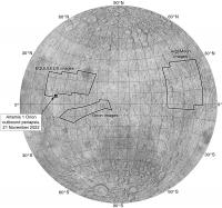
Since OMOTENASHI has failed (and I doubt it can be revived, certainly not for a lunar mission) I will use this thread for news of the other cubesats. I have been avoiding the Artemis 1 mission and imaging from Orion because they are part of a crewed mission project, which we don't cover, but the cubesats seem to be reasonable for us here. Orion has cameras which have taken nice images of the Moon,and you can see some of them on the Artemis threads (discusson and update) at NASASPACEFLIGHT.COM.
Here I will post this map showing image coverage (ignoring global views) from Orion, EQUUELEUS and ArgoMoon, the latter two being a Japanese cubesat and an Italian cubesat. Argomoon was built by the same people who did the Liceacubes for DART. The EQUULEUS images were taken with the DELPHINUS camera which is intended to take images of the unlit part of the far side to look for impact flashes. Phil
-------------------- ... because the Solar System ain't gonna map itself.
Also to be found posting similar content on https://mastodon.social/@PhilStooke Maps for download (free PD: https://upload.wikimedia.org/wikipedia/comm...Cartography.pdf NOTE: everything created by me which I post on UMSF is considered to be in the public domain (NOT CC, public domain) |
|
|
|
|
|
|
Nov 27 2022, 10:32 PM
Post
#8
|
|
 Member Group: Members Posts: 227 Joined: 13-October 09 From: Olympus Mons Member No.: 4972 |
NEA Scout doesn't seem to have made it. Was hoping scout could map another pile of space boulders. Cubesats are probably safe UMSF territory as they are like Galileo or Magellan, piggybacking on inhabited spaceflight.
-------------------- "Thats no moon... IT'S A TRAP!"
|
|
|
|
|
Nov 29 2022, 06:40 AM
Post
#9
|
|
|
Merciless Robot Group: Admin Posts: 8783 Joined: 8-December 05 From: Los Angeles Member No.: 602 |
Ride-along cubesats for planetary exploration launching with crewed missions are absolutely allowed to be discussed here.
 Topic title changed to reflect this. Topic title changed to reflect this.
-------------------- A few will take this knowledge and use this power of a dream realized as a force for change, an impetus for further discovery to make less ancient dreams real.
|
|
|
|
|
Nov 29 2022, 07:34 AM
Post
#10
|
|||
|
Solar System Cartographer Group: Members Posts: 10162 Joined: 5-April 05 From: Canada Member No.: 227 |
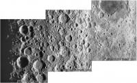
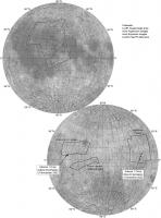
Here are the three images from EQUULEUS (courtesy of JAXA and the mission) fitted together. They overlap very slightly, though a graphic posted by JAXA suggests they don't. EQUULEUS is is a big orbit around the Earth from which it will transition to an orbit around the L2 point above the far side. One of its tasks there is to image the unlit part of the far side to look for impact flashes, something which is routinely done from Earth for our side of the Moon.
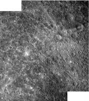
And the two ArgoMoon images which overlap considerably, courtesy of the Italian Space Agency. ArgoMoon is in a large elongated orbit about Earth which will encounter the Moon from time to time, giving more imaging opportunities. The long crater chains were originally named after Soviet space research facilities when discovered in Zond 3 images.
Phil -------------------- ... because the Solar System ain't gonna map itself.
Also to be found posting similar content on https://mastodon.social/@PhilStooke Maps for download (free PD: https://upload.wikimedia.org/wikipedia/comm...Cartography.pdf NOTE: everything created by me which I post on UMSF is considered to be in the public domain (NOT CC, public domain) |
||
|
|
|
||
|
Nov 29 2022, 07:55 AM
Post
#11
|
|
|
Member Group: Members Posts: 233 Joined: 14-January 22 Member No.: 9140 |
Beautiful stuff. The rays in the upper right corner of that ArgoMoon pictures have unusually sharp edges. Interesting to contemplate the circumstances that led to that.
|
|
|
|
|
Dec 4 2022, 09:56 PM
Post
#12
|
|
|
Solar System Cartographer Group: Members Posts: 10162 Joined: 5-April 05 From: Canada Member No.: 227 |
Looking at that Argomoon image, and some of the media postings about it...
e.g. this: https://www.facebook.com/ArgotecSpace/posts/584682640324135/ They say the prominent crater with bright rays (and a sector missing rays) is Jackson. It's not - this crater is Ohm. Jackson is similar at a glance but much further east.. StargazeInWonder: if that missing sector is what you are referring to, it is probably caused by the impact being oblique rather than near-vertical. The projectile approached along the central part of the dark sector and ejected material principally downrange and sideways. Phil -------------------- ... because the Solar System ain't gonna map itself.
Also to be found posting similar content on https://mastodon.social/@PhilStooke Maps for download (free PD: https://upload.wikimedia.org/wikipedia/comm...Cartography.pdf NOTE: everything created by me which I post on UMSF is considered to be in the public domain (NOT CC, public domain) |
|
|
|
|
Dec 8 2022, 08:02 AM
Post
#13
|
||
|
Solar System Cartographer Group: Members Posts: 10162 Joined: 5-April 05 From: Canada Member No.: 227 |
Image coverage update, showing nearside views from the Orion navigation cameras. See images here (moon images scattered among other mission images):
https://www.flickr.com/photos/nasa2explore/ And this image in particular: https://www.flickr.com/photos/nasa2explore/52549239085/ must be one of the most spectacular views of the Moon I have ever seen. Aristarchus Plateau on the terminator. Phil
-------------------- ... because the Solar System ain't gonna map itself.
Also to be found posting similar content on https://mastodon.social/@PhilStooke Maps for download (free PD: https://upload.wikimedia.org/wikipedia/comm...Cartography.pdf NOTE: everything created by me which I post on UMSF is considered to be in the public domain (NOT CC, public domain) |
|
|
|
|
|
|
Dec 25 2022, 05:36 PM
Post
#14
|
|
|
Solar System Cartographer Group: Members Posts: 10162 Joined: 5-April 05 From: Canada Member No.: 227 |
The cubesat missions are not over yet. Both EQUULEUS and ArgoMoon are in roughly month-long orbits which will re-encounter the Moon. I have seen two different plans for ArgoMoon, one with 7 lunar flybys (quite high altitude) over 6 months, the other with 2 very high flybys and a third at 5000 km which will permit nice imaging. That last one is in about 6 months, followed by escape to heliocentric orbit. EQUULEUS is in a similar orbit but it will gradually adjust its orbit via many flybys to end up in an L2 halo orbit. It should take more images too.
Phil -------------------- ... because the Solar System ain't gonna map itself.
Also to be found posting similar content on https://mastodon.social/@PhilStooke Maps for download (free PD: https://upload.wikimedia.org/wikipedia/comm...Cartography.pdf NOTE: everything created by me which I post on UMSF is considered to be in the public domain (NOT CC, public domain) |
|
|
|
|
Feb 21 2023, 07:40 AM
Post
#15
|
|
|
Solar System Cartographer Group: Members Posts: 10162 Joined: 5-April 05 From: Canada Member No.: 227 |
EQUULEUS lives! And recently imaged Comet ZTF:
https://twitter.com/EQUULEUS_en/status/1627864630419931137 Phil -------------------- ... because the Solar System ain't gonna map itself.
Also to be found posting similar content on https://mastodon.social/@PhilStooke Maps for download (free PD: https://upload.wikimedia.org/wikipedia/comm...Cartography.pdf NOTE: everything created by me which I post on UMSF is considered to be in the public domain (NOT CC, public domain) |
|
|
|
|
Mar 24 2023, 03:16 AM
Post
#16
|
|
|
Solar System Cartographer Group: Members Posts: 10162 Joined: 5-April 05 From: Canada Member No.: 227 |
By assembling bits and pieces from a few websites including Project Pluto and the Minor Planet Center, plus Scott Tilley on Twitter, I have made this brief summary of recent activities by EQUULEUS:
"On 16 March 2023 astronomers detected an apparent asteroid, A10TGEB, which was soon found to be EQUULEUS. It had made a lunar flyby at an altitude of c. 50000 km on 10 March, before that 'discovery'. It will pass by Earth at c. 35000 km altitude on 6 April 2023 and on 27 May it will pass by the Moon at 30400 +/- 8800 km, changing its orbit from 62580 by 620910 km to 162000 by 990000 km." Basically, EQUULEUS is in a large orbit of Earth which is perturbed by lunar flybys and is being shaped gradually until the spacecraft can slip into an orbit about the Earth-Moon L2 point. From L2 it will study Earth's plasma and look for meteorite impacts on the Moon's unilluminated portion. As far as I can tell it is still healthy. If anyone has additional details of the trajectory or hears of any other activity, please post it or let me know. Phil -------------------- ... because the Solar System ain't gonna map itself.
Also to be found posting similar content on https://mastodon.social/@PhilStooke Maps for download (free PD: https://upload.wikimedia.org/wikipedia/comm...Cartography.pdf NOTE: everything created by me which I post on UMSF is considered to be in the public domain (NOT CC, public domain) |
|
|
|
|
Apr 1 2023, 09:19 PM
Post
#17
|
|
|
Solar System Cartographer Group: Members Posts: 10162 Joined: 5-April 05 From: Canada Member No.: 227 |
https://www.wired.it/article/artemis-1-viag...luca-parmitano/
This article (in Italian, and published during the mission) seems to say that Argomoon succeeded in imaging the upper stage of Artemis 1 and later cubesat deployments, but no images have been released (there would be some ITAR or other restrictions, though nothing that should warrant a total blackout). A clearer update would be useful. Phil -------------------- ... because the Solar System ain't gonna map itself.
Also to be found posting similar content on https://mastodon.social/@PhilStooke Maps for download (free PD: https://upload.wikimedia.org/wikipedia/comm...Cartography.pdf NOTE: everything created by me which I post on UMSF is considered to be in the public domain (NOT CC, public domain) |
|
|
|
|
Apr 5 2023, 08:03 PM
Post
#18
|
|
|
Member Group: Members Posts: 401 Joined: 5-January 07 From: Manchester England Member No.: 1563 |
Thank you for the updates and detective work Phil Stooke!
-------------------- |
|
|
|
|
Apr 23 2023, 06:10 PM
Post
#19
|
||
|
Solar System Cartographer Group: Members Posts: 10162 Joined: 5-April 05 From: Canada Member No.: 227 |
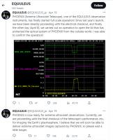
Actual positive news for a change. But buried on the Japanese Twitter account for EQUULEUS (not on the English language version yet). This is machine-translated.
The Phoenix camera is designed to image Earth's plasmasphere in the ultraviolet. Apollo 16's UV camera took an image like that and so did an instrument on the Chang'e 3 lander. I don't know where EQUULEUS is now - maybe near L2 and maybe not, who can say? EDIT: Aha, it is due to make a lunar flyby on 27 May which will change its orbit, part of the long process of getting into its L2 halo position with minimal use of fuel. Chance of some Moon images then! Phil -------------------- ... because the Solar System ain't gonna map itself.
Also to be found posting similar content on https://mastodon.social/@PhilStooke Maps for download (free PD: https://upload.wikimedia.org/wikipedia/comm...Cartography.pdf NOTE: everything created by me which I post on UMSF is considered to be in the public domain (NOT CC, public domain) |
|
|
|
|
|
|
May 3 2023, 11:16 AM
Post
#20
|
|
|
Senior Member Group: Members Posts: 2920 Joined: 14-February 06 From: Very close to the Pyrénées Mountains (France) Member No.: 682 |
-------------------- |
|
|
|
|
May 17 2023, 08:58 PM
Post
#21
|
|
|
Solar System Cartographer Group: Members Posts: 10162 Joined: 5-April 05 From: Canada Member No.: 227 |
Here is Jonathan's Space Report, No. 819, the most recent edition.
https://planet4589.org/space/jsr/back/news.819.txt A good summary of the fate of the various cubesats and some other missions. Phil -------------------- ... because the Solar System ain't gonna map itself.
Also to be found posting similar content on https://mastodon.social/@PhilStooke Maps for download (free PD: https://upload.wikimedia.org/wikipedia/comm...Cartography.pdf NOTE: everything created by me which I post on UMSF is considered to be in the public domain (NOT CC, public domain) |
|
|
|
|
May 26 2023, 03:15 AM
Post
#22
|
|
|
Solar System Cartographer Group: Members Posts: 10162 Joined: 5-April 05 From: Canada Member No.: 227 |
I was just at the Lunar Surface Science Workshop, where we had a bit of news of two Artemis cubesats.
LunaH-Map couldn't get its thrusters to fire so couldn't go into lunar orbit, but it did make neutron measurements as it flew past the Moon. The closest approach was over roughly 15 N, 120 E on the far side, where the neutron data sampled a broad region maybe 60 degrees across. Before and after that it made effectively unresolved full-disk observations of the near side and far side. No data analysis yet but it will go into the PDS. BioSentinel, an Ames mission to grow yeast and observe effects of radiation on it, also carried a radiation detector. The biology experiment was tried but higher than expected humidity in the sealed experiment made it rather ineffective. The radiation detector was successful and sampled two Coronal Mass Ejection events. Overall, not terribly useful but a lot was learned about experiment design which will apply to a CLPS mission to do biology on the Moon. Phil -------------------- ... because the Solar System ain't gonna map itself.
Also to be found posting similar content on https://mastodon.social/@PhilStooke Maps for download (free PD: https://upload.wikimedia.org/wikipedia/comm...Cartography.pdf NOTE: everything created by me which I post on UMSF is considered to be in the public domain (NOT CC, public domain) |
|
|
|
|
Jul 13 2023, 08:38 PM
Post
#23
|
|
|
Solar System Cartographer Group: Members Posts: 10162 Joined: 5-April 05 From: Canada Member No.: 227 |
https://xtech.nikkei.com/atcl/nxt/column/18/00001/08181/
This article (in Japanese) says EQUULEUS lost power on 18 May 2023 apparently because it lost attitude control and began spinning. There might be some hope of re-establishing contact but I would not be optimistic. That appears to draw to a conclusion the sorry tale of the Artemis 1 cubesats. There will be no cubesats on Artemis 2. Phil -------------------- ... because the Solar System ain't gonna map itself.
Also to be found posting similar content on https://mastodon.social/@PhilStooke Maps for download (free PD: https://upload.wikimedia.org/wikipedia/comm...Cartography.pdf NOTE: everything created by me which I post on UMSF is considered to be in the public domain (NOT CC, public domain) |
|
|
|
 |

|
Lo-Fi Version | Time is now: 16th May 2024 - 12:43 AM |
|
RULES AND GUIDELINES Please read the Forum Rules and Guidelines before posting. IMAGE COPYRIGHT |
OPINIONS AND MODERATION Opinions expressed on UnmannedSpaceflight.com are those of the individual posters and do not necessarily reflect the opinions of UnmannedSpaceflight.com or The Planetary Society. The all-volunteer UnmannedSpaceflight.com moderation team is wholly independent of The Planetary Society. The Planetary Society has no influence over decisions made by the UnmannedSpaceflight.com moderators. |
SUPPORT THE FORUM Unmannedspaceflight.com is funded by the Planetary Society. Please consider supporting our work and many other projects by donating to the Society or becoming a member. |
|