Perseverance Route Map |

  |
Perseverance Route Map |
 Mar 7 2021, 10:39 PM Mar 7 2021, 10:39 PM
Post
#16
|
|
|
Member  Group: Members Posts: 248 Joined: 25-February 21 From: Waltham, Massachussetts, U.S.A. Member No.: 8974 |
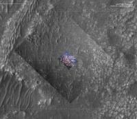
I did find a slightly earlier frame of the Rover Lookdown camera which has a bit of the current location and is higher resolution than the HiRISE mosaic. It is a bit blurry because the Descent Stage had not fully stabilized and is from a more oblique perspective. But the registration went pretty well. Here is how the map looks with that frame (and higher contrast):
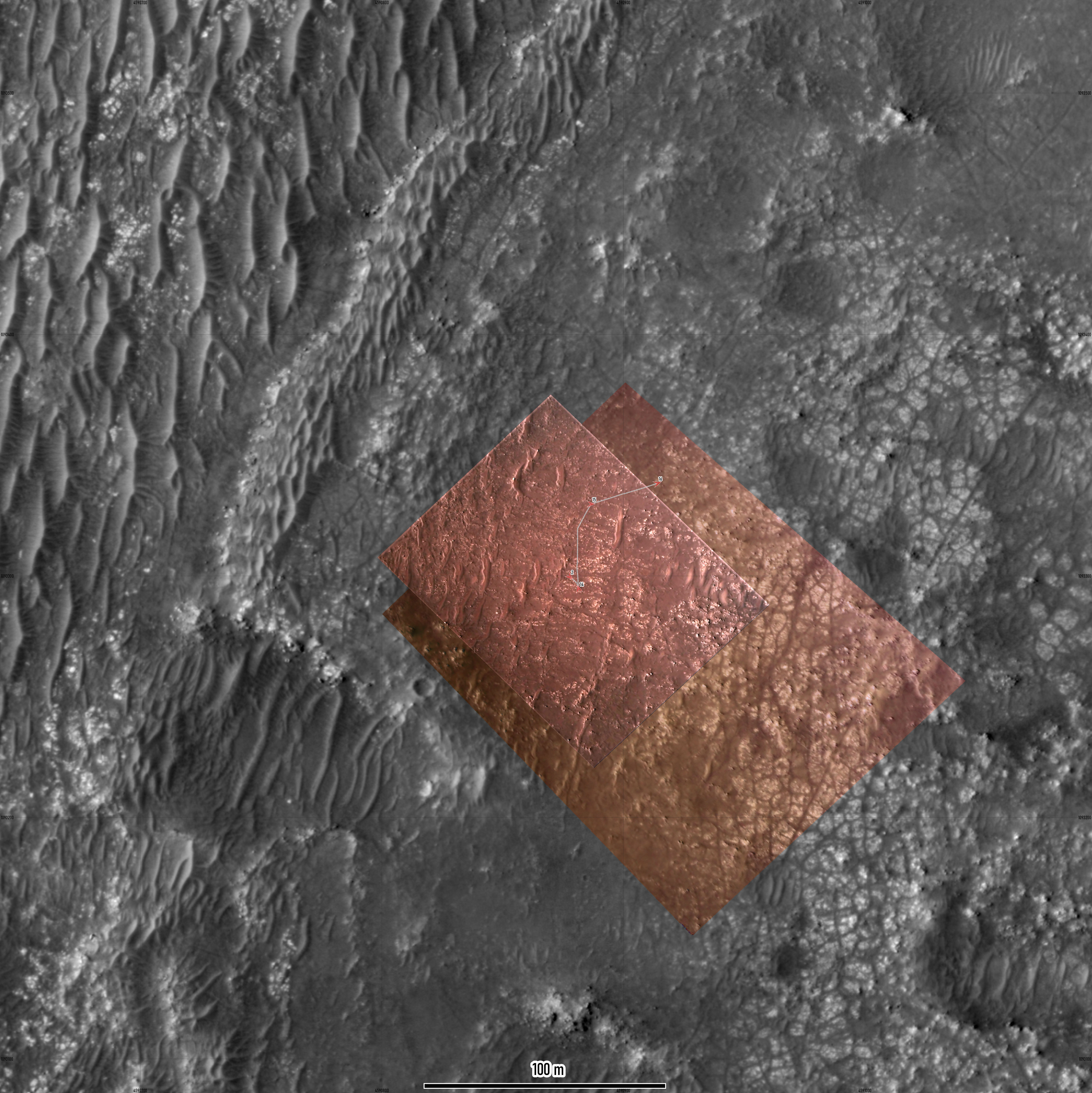 The width of the traverse path is 0.5 m. The boulders are imaged quite a bit better than in the HiRISE mosaic. -------------------- --
Andreas Plesch, andreasplesch at gmail dot com |
 |
 
|
|
Mar 10 2021, 03:21 AM
Post
#17
|
||
|
Solar System Cartographer Group: Members Posts: 10149 Joined: 5-April 05 From: Canada Member No.: 227 |
I revised my map from earlier to include the sol 16 drive.
Phil
-------------------- ... because the Solar System ain't gonna map itself.
Also to be found posting similar content on https://mastodon.social/@PhilStooke NOTE: everything created by me which I post on UMSF is considered to be in the public domain (NOT CC, public domain) |
|
|
|
|
|
|
Mar 10 2021, 09:27 PM
Post
#18
|
|||
|
Solar System Cartographer Group: Members Posts: 10149 Joined: 5-April 05 From: Canada Member No.: 227 |
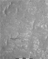
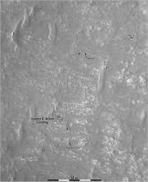
Iteratively building these maps. I have added the two SuperCam target names now, one on each map.
Phil
-------------------- ... because the Solar System ain't gonna map itself.
Also to be found posting similar content on https://mastodon.social/@PhilStooke NOTE: everything created by me which I post on UMSF is considered to be in the public domain (NOT CC, public domain) |
||
|
|
|
||
|
Mar 10 2021, 09:45 PM
Post
#19
|
|
|
Member Group: Members Posts: 240 Joined: 18-July 06 Member No.: 981 |
Thanks as always Phil. This is a great resource.
|
|
|
|
|
Mar 10 2021, 10:34 PM
Post
#20
|
|||
|
Junior Member Group: Members Posts: 31 Joined: 10-August 12 Member No.: 6526 |
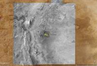
For those of you who might want to navigate this trip with Google Mars/Earth, as well, I've prepared some overlays using the large basemaps created by the USGS that were mentioned earlier in this thread.
The overview map is 5322x5040 with 6m/pixel resolution:
The larger 6.9GB map was broken into manageable 4000x4000 tiles with 0.25m/pixel resolution:
You can see some overlays of the various HiRISE and rover downcam images. For the rover track, I cobbled together a script that scrapes the "Where is Perseverance?" web page. Right now I have to run the script manually, but plan to automate it once I can make it more robust. You can download a zip file (55MB) with everything or download files individually at the site. Additional map tiles will be added to the site soon to accommodate the planned route. The elevation data currently used by GE is low resolution, so only the largest features like the crater rim render well with everything else looking kind of flat. One thing I like about GE is that it provides an easy way to geolocate the interesting images presented in this forum for future reference. Mark |
||
|
|
|
||
|
Mar 11 2021, 04:57 AM
Post
#21
|
|||
|
Junior Member Group: Members Posts: 31 Joined: 10-August 12 Member No.: 6526 |
... and to continue the discussion on registration of the json track data from the "Where is Perseverance?" page with the USGS basemap, here's the post-landing HiRISE image layered on top of the Google Earth tiles:
This overlay and the downcam overlays (below) were manually registered (to the best of my ability and patience) with the Google Earth tiles derived from the USGS basemaps. These tiles were extracted from the original equirectangular basemap with a program using the supplied metadata (so no human inaccuracies).
So, yeah, there seems to be general agreement with the other maps here...  Mark |
||
|
|
|
||
|
Mar 12 2021, 12:30 AM
Post
#22
|
||
|
Solar System Cartographer Group: Members Posts: 10149 Joined: 5-April 05 From: Canada Member No.: 227 |
This is the sol 20 drive. The location should be good, the path is an estimate.
Phil
-------------------- ... because the Solar System ain't gonna map itself.
Also to be found posting similar content on https://mastodon.social/@PhilStooke NOTE: everything created by me which I post on UMSF is considered to be in the public domain (NOT CC, public domain) |
|
|
|
|
|
|
Mar 12 2021, 02:55 AM
Post
#23
|
|
|
Member Group: Members Posts: 248 Joined: 25-February 21 From: Waltham, Massachussetts, U.S.A. Member No.: 8974 |
Here is my best estimate of the current location, at sol 20 after the drive:
 The rectangle is the approximate foot print of the rover, to scale. This is mostly based on analysis of this Navcam image: 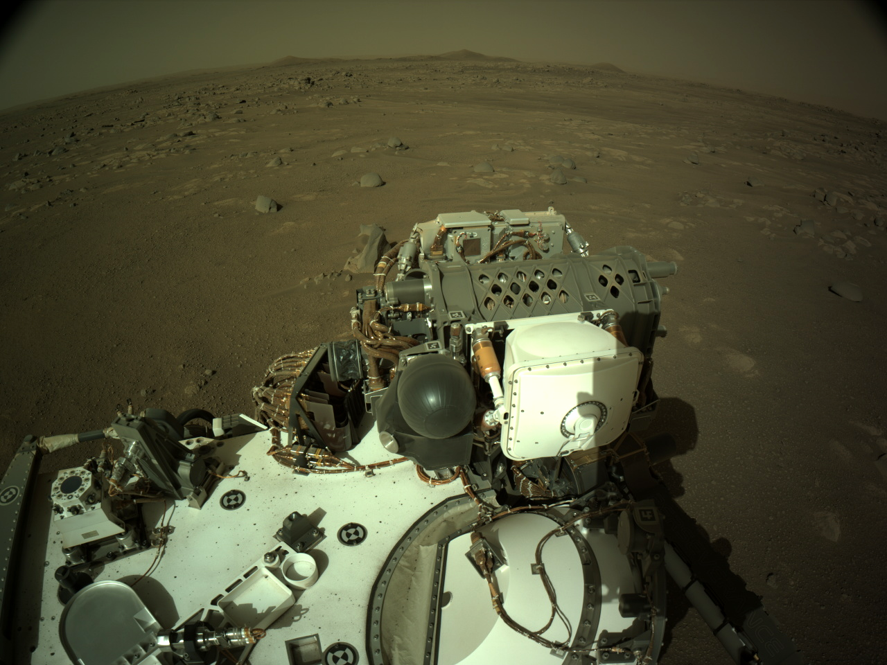 Starting from the dark, small, almost boulder free crater in the middle ground (apparently a word), I believe one can identify sets of boulders to track back to the rover. I guess we will see soon enough. The crater seems really smooth and may be a good arena for heli testing. There are a few ripples, so perhaps the rover would not venture inside. -------------------- --
Andreas Plesch, andreasplesch at gmail dot com |
|
|
|
|
Mar 12 2021, 09:13 AM
Post
#24
|
||
 Member Group: Members Posts: 349 Joined: 20-June 07 From: Slovenia Member No.: 2461 |
Sol 20 update with newly available raw EDL images. I would not recommend GE for geo-referencing of images as it only allows 4 (corner) control points. |
|
|
|
|
|
|
Mar 12 2021, 01:42 PM
Post
#25
|
|
|
Member Group: Members Posts: 248 Joined: 25-February 21 From: Waltham, Massachussetts, U.S.A. Member No.: 8974 |
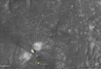
My estimate was a few meters off. With the latest geojson:
 The width of the path corresponds to the width of the rover (ca. 2.7m). https://mars.nasa.gov/mmgis-maps/M20/Layers..._waypoints.json now also has a few more fields: distance, drive and elevation among them. In the helicopter introduction last night, they mentioned that its range could be about 100m x 30m, after initial shorter tests. -------------------- --
Andreas Plesch, andreasplesch at gmail dot com |
|
|
|
|
Mar 12 2021, 07:16 PM
Post
#26
|
||
|
Junior Member Group: Members Posts: 31 Joined: 10-August 12 Member No.: 6526 |
For the Google Mars track, there's now an automatic update ability available for the client side. What this means is that Google Mars will check for an update every 6 hours (while GM is open) or you can manually refresh the track. This will download the track from my server. However, the track on my server is still only updated manually by me running a script so there will be some (human induced) latency until I fully automate the back-end (which will be soon).
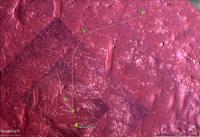
Download & open track-updater.kmz and move it to the "mars2020" folder on the GM side panel. You can delete the old "track sols 2-16" folder. The new "track-updater" folder will automatically refresh in the future. To manually refresh, there's a refresh menu item when right-clicking track-updater. If you want, you can change the refresh interval or disable it by going to the Properties>Refresh tab. Here's a look at the current track:
Note: While all the waypoints and traverses are displayed correctly, they are listed out of order on the side panel. This will be fixed in the next automatic refresh now that I've studied the json data a little closer. Mark |
|
|
|
|
|
|
Mar 15 2021, 08:26 PM
Post
#27
|
||
|
Solar System Cartographer Group: Members Posts: 10149 Joined: 5-April 05 From: Canada Member No.: 227 |
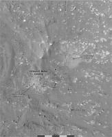
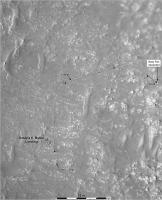
The images for the last couple of days have not been helpful for making panoramas so it's taken a while to get to this map. Update to sol 23 - a drive back along the tracks away from the belly pan.
Phil
I register my maps to the HiRISE orthophotos, so they share projection details with those images. There may be small mis-matches between the various maps appearing in this thread but they are not worth worrying about, they all tell essentially the same story. -------------------- ... because the Solar System ain't gonna map itself.
Also to be found posting similar content on https://mastodon.social/@PhilStooke NOTE: everything created by me which I post on UMSF is considered to be in the public domain (NOT CC, public domain) |
|
|
|
|
|
|
Mar 16 2021, 12:12 AM
Post
#28
|
|
|
Member Group: Members Posts: 248 Joined: 25-February 21 From: Waltham, Massachussetts, U.S.A. Member No.: 8974 |
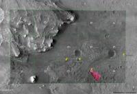
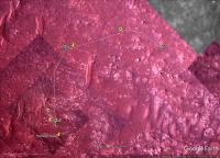
Here is a map using the latest geojson, with registered EDL downlook imagery. The width of the path is 2.7m, the black circles are 1m in diameter. The faint arrows show yaw as reported in the way points. The projection is orthographic, centered at the landing ellipse (77.4298 E, 18.4663 N).

-------------------- --
Andreas Plesch, andreasplesch at gmail dot com |
|
|
|
|
Mar 16 2021, 03:50 AM
Post
#29
|
|
|
Merciless Robot Group: Admin Posts: 8783 Joined: 8-December 05 From: Los Angeles Member No.: 602 |
Some members have observed, and I agree, that this thread has drifted a bit from its intent. For our new members, Phil's map threads have generally served as navigation/situational awareness reference resources on UMSF for every rover since Spirit to help us all follow the journeys in those ways. Naturally, some questions and observations occasionally pop up in them but this has turned into a full-blown tech discussion.
I was gonna create a new Mars Cartography thread, but lo and behold it turns out that we have one already conveniently called Mars Cartography. 15 posts have been moved there, and I encourage all to please continue that most interesting and informative discussion there. Thanks! 
-------------------- A few will take this knowledge and use this power of a dream realized as a force for change, an impetus for further discovery to make less ancient dreams real.
|
|
|
|
|
Mar 16 2021, 07:42 AM
Post
#30
|
||
|
Solar System Cartographer Group: Members Posts: 10149 Joined: 5-April 05 From: Canada Member No.: 227 |
Good idea.
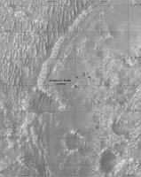
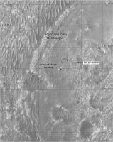
I have adjusted the base of my intermediate scale map to include the Belly Pan location, so here is an update to sol 23. Phil
-------------------- ... because the Solar System ain't gonna map itself.
Also to be found posting similar content on https://mastodon.social/@PhilStooke NOTE: everything created by me which I post on UMSF is considered to be in the public domain (NOT CC, public domain) |
|
|
|
|
|
|

|
Lo-Fi Version | Time is now: 23rd April 2024 - 02:17 PM |
|
RULES AND GUIDELINES Please read the Forum Rules and Guidelines before posting. IMAGE COPYRIGHT |
OPINIONS AND MODERATION Opinions expressed on UnmannedSpaceflight.com are those of the individual posters and do not necessarily reflect the opinions of UnmannedSpaceflight.com or The Planetary Society. The all-volunteer UnmannedSpaceflight.com moderation team is wholly independent of The Planetary Society. The Planetary Society has no influence over decisions made by the UnmannedSpaceflight.com moderators. |
SUPPORT THE FORUM Unmannedspaceflight.com is funded by the Planetary Society. Please consider supporting our work and many other projects by donating to the Society or becoming a member. |
|