Journey to Mt Sharp - Part 4: Beyond the Kimberley, Sol 634 [May 19, '14] to 706 [Jul 31, '14] |

  |
Journey to Mt Sharp - Part 4: Beyond the Kimberley, Sol 634 [May 19, '14] to 706 [Jul 31, '14] |
 Jun 10 2014, 02:35 PM Jun 10 2014, 02:35 PM
Post
#166
|
|
|
Member  Group: Members Posts: 201 Joined: 16-December 13 Member No.: 7067 |
New sights! Anaglyph pan album for 655
http://imgur.com/a/V5peX And the stretched version http://imgur.com/a/TGs8x I finally managed to 'see' a crosseyed image this weekend, so now anaglyphs feel like putting the training-wheels back on the bike |
 |
 
|
|
Jun 10 2014, 02:59 PM
Post
#167
|
|
 Senior Member Group: Members Posts: 2492 Joined: 15-January 05 From: center Italy Member No.: 150 |
Great views, anticitizen2!
I think we are seeing the two (already highlighted) circular features in the central frame, probably Curiosity will visit them in next days... -------------------- I always think before posting! - Marco -
|
|
|
|
|
Jun 10 2014, 03:09 PM
Post
#168
|
||
|
Solar System Cartographer Group: Members Posts: 10151 Joined: 5-April 05 From: Canada Member No.: 227 |
A quick guess as to our location on sol 655. I will update the map later. (EDIT - I changed the attached file and corrected the location)
Phil
-------------------- ... because the Solar System ain't gonna map itself.
Also to be found posting similar content on https://mastodon.social/@PhilStooke Maps for download (free PD: https://upload.wikimedia.org/wikipedia/comm...Cartography.pdf NOTE: everything created by me which I post on UMSF is considered to be in the public domain (NOT CC, public domain) |
|
|
|
|
|
|
Jun 10 2014, 06:56 PM
Post
#169
|
|
|
Solar System Cartographer Group: Members Posts: 10151 Joined: 5-April 05 From: Canada Member No.: 227 |
According to https://twitter.com/Matt_Heverly/status/476343275683454976, Curiosity just passed the 7 km mark. Joe's drive log has us over 300 m past that. It's hard to reconcile everything, but I guess I have to go with the project.
Phil -------------------- ... because the Solar System ain't gonna map itself.
Also to be found posting similar content on https://mastodon.social/@PhilStooke Maps for download (free PD: https://upload.wikimedia.org/wikipedia/comm...Cartography.pdf NOTE: everything created by me which I post on UMSF is considered to be in the public domain (NOT CC, public domain) |
|
|
|
|
Jun 10 2014, 08:14 PM
Post
#170
|
|
 Administrator Group: Admin Posts: 5172 Joined: 4-August 05 From: Pasadena, CA, USA, Earth Member No.: 454 |
Hmm. Might that number correct for slip?
-------------------- My website - My Patreon - @elakdawalla on Twitter - Please support unmannedspaceflight.com by donating here.
|
|
|
|
|
Jun 10 2014, 08:24 PM
Post
#171
|
|
|
Solar System Cartographer Group: Members Posts: 10151 Joined: 5-April 05 From: Canada Member No.: 227 |
Yes, that's what is going on, we always have this conflict between numbers.
Phil -------------------- ... because the Solar System ain't gonna map itself.
Also to be found posting similar content on https://mastodon.social/@PhilStooke Maps for download (free PD: https://upload.wikimedia.org/wikipedia/comm...Cartography.pdf NOTE: everything created by me which I post on UMSF is considered to be in the public domain (NOT CC, public domain) |
|
|
|
|
Jun 10 2014, 09:17 PM
Post
#172
|
|
 Member Group: Members Posts: 334 Joined: 11-December 12 From: The home of Corby Crater (Corby-England) Member No.: 6783 |
Following on from my previous post (#156), am I to conclude that this is a sequence of shots from an 'autofocus assist' laser?
The other question I had was that if the images were captured minutes apart, why does the ripple effect appear the way it does? Were they taken minutes apart or just received/uploaded minutes apart? |
|
|
|
|
Jun 10 2014, 11:08 PM
Post
#173
|
|
 Senior Member Group: Members Posts: 4246 Joined: 17-January 05 Member No.: 152 |
Yeah, from what I read the CW laser is used for autofocus. The laser fires and the secondary is stepped through some range of travel, while the returned intensity is monitored. I think the maximum intensity corresponds to the in-focus position. But someone may correct me/elaborate on this. Normally the CW laser is used for focusing but no images are taken/returned while it is running. But it looks like they decided to do that on that sol, maybe to check the alignment of the CW laser.
I assume each firing of the main laser blasts the dust farther out. When the images are combined into an animation it looks like a smooth outwards ripple-like motion, but in reality it happens in short bursts with each main laser pulse. I think the timestamps correspond to the time the images were taken. |
|
|
|
|
Jun 11 2014, 04:15 PM
Post
#174
|
|
|
Member Group: Members Posts: 201 Joined: 16-December 13 Member No.: 7067 |
Yesterday's pan album is now complete with the images of the tracks: Sol 655 and stretched
Today's view is even more exciting! Sol 656 anaglyph album Sol 656 stretched anaglyph album  Here are the 655 and 656 drives from the HazCam And the drives anaglyph'd The first segment of the 656 drive in the NavCam Two pairs of images looking ahead at the circular features - http://i.imgur.com/293DjsA.gif 
|
|
|
|
|
Jun 12 2014, 03:00 PM
Post
#175
|
|
|
Senior Member Group: Members Posts: 2346 Joined: 7-December 12 Member No.: 6780 |
QUOTE (fredk @ Jun 10 2014, 02:53 AM)  ... perhaps to check the alignment. This presumption appears to be correct. Here the processed PDS previews of three Sol 283 alignment tests: Targets Sulky_CCAM, East_River, and Long_Island. Raw ChemCam images contain ghosts and smearing, most obvious for images of bright objects in a dark environment, as in these cases. Metadata about the ChemCam images confirming the alignment tests can be found in file msl_ccam_obs.csv of this PDS directory. Excerpt: QUOTE 283,CR0,422611899,CR0_422611899EDR_F0060082CCAM02283M1.IMG,Image,East_River,ccam
02283,No,5.27021,3.033,1.238, , , , ,1,1, , , 11:25:38:094,6,82,6,Single obs,alignment test,,,,,,Flat Rock Surface |
|
|
|
|
Jun 12 2014, 04:09 PM
Post
#176
|
|
|
Senior Member Group: Members Posts: 4246 Joined: 17-January 05 Member No.: 152 |
Thanks for digging that up, Gerald. I guess they wanted to test the alignment over a range of target distances.
|
|
|
|
|
Jun 12 2014, 04:41 PM
Post
#177
|
|
|
Member Group: Members Posts: 910 Joined: 4-September 06 From: Boston Member No.: 1102 |
Trying to keep speculation here rather than Map Thread, it seems Marco's northern route is not northern enough. We are now northwest of where the yellow route turned south to join the green provisional route. Does it now look like we will not be joining the green route any time soon, but rather loosely paralleling it 200-300 m to the north?
Marco, maybe you could do a new look ahead from where we are now. -------------------- |
|
|
|
|
Jun 12 2014, 05:33 PM
Post
#178
|
|
 Senior Member Group: Members Posts: 1619 Joined: 12-February 06 From: Bergerac - FR Member No.: 678 |
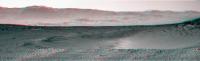
Sol 657 Navcam panoramic after such a long drive
-------------------- |
|
|
|
|
Jun 12 2014, 05:36 PM
Post
#179
|
||
 Senior Member Group: Members Posts: 1465 Joined: 9-February 04 From: Columbus OH USA Member No.: 13 |
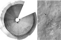
Dustbowl ahoy!
-------------------- |
|
|
|
|
|
|
Jun 12 2014, 06:45 PM
Post
#180
|
||
|
Senior Member Group: Members Posts: 1074 Joined: 21-September 07 From: Québec, Canada Member No.: 3908 |
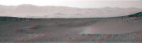
There seems to be a problem with your anaglyph. Try this one:
|
|
|
|
|
|
|

|
Lo-Fi Version | Time is now: 25th April 2024 - 02:03 PM |
|
RULES AND GUIDELINES Please read the Forum Rules and Guidelines before posting. IMAGE COPYRIGHT |
OPINIONS AND MODERATION Opinions expressed on UnmannedSpaceflight.com are those of the individual posters and do not necessarily reflect the opinions of UnmannedSpaceflight.com or The Planetary Society. The all-volunteer UnmannedSpaceflight.com moderation team is wholly independent of The Planetary Society. The Planetary Society has no influence over decisions made by the UnmannedSpaceflight.com moderators. |
SUPPORT THE FORUM Unmannedspaceflight.com is funded by the Planetary Society. Please consider supporting our work and many other projects by donating to the Society or becoming a member. |
|