First public release of Kaguya data |

  |
First public release of Kaguya data |
 Nov 10 2009, 12:50 AM Nov 10 2009, 12:50 AM
Post
#76
|
||
|
Newbie  Group: Members Posts: 14 Joined: 9-November 09 Member No.: 5032 |
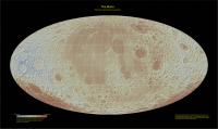
I downloaded the Kaguya LALT_GGT_NUM data set from JAXA and built a digital terrain model with ArcGIS software. I then applied some hypsometric rendering techniques and made these maps. Here's the first map, a global view of the moon built from the surface model and no albedo data.
Attached thumbnail(s)
|
|
 |
 
|
|
|
Nov 10 2009, 12:51 AM
Post
#77
|
||
|
Newbie Group: Members Posts: 14 Joined: 9-November 09 Member No.: 5032 |
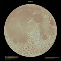
Another lunar hypsometric map, the near side of the moon
Attached thumbnail(s)
|
|
|
|
|
|
|
Nov 10 2009, 12:52 AM
Post
#78
|
||
|
Newbie Group: Members Posts: 14 Joined: 9-November 09 Member No.: 5032 |
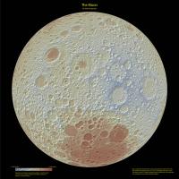
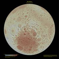
The far side of the moon.
Attached thumbnail(s)
|
|
|
|
|
|
|
Nov 10 2009, 12:56 AM
Post
#79
|
||
|
Newbie Group: Members Posts: 14 Joined: 9-November 09 Member No.: 5032 |
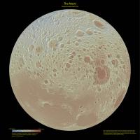
Here's the north pole perspective
Attached thumbnail(s)
|
|
|
|
|
|
|
Nov 10 2009, 01:01 AM
Post
#80
|
||
|
Newbie Group: Members Posts: 14 Joined: 9-November 09 Member No.: 5032 |
And the perspective above the south pole of the moon.
If you are curious about my mapping method, I applied the cartographic tools described at http://blogs.esri.com/Support/blogs/mappin...de-toolbox.aspx This is a modern implementation of the cartographic relief methods developed by the Swiss cartographer Eduard Imhof in the 1930's. Originally designed for maps of the Alps, this mapping method shows a new "perspective" of the moon. It's a bit weird looking at the "naked" moon without it's ray systems and albedo differences between the mare and highlands, but it's still pretty recognizable. In term of hypsometric relief, the far side is much more interesting then the near side. regards, Michael Zeiler, ESRI
Attached thumbnail(s)
|
|
|
|
|
|
|
Nov 10 2009, 02:40 AM
Post
#81
|
|
|
Junior Member Group: Members Posts: 35 Joined: 28-September 05 From: Seattle, WA Member No.: 514 |
QUOTE (mhoward @ Nov 9 2009, 01:24 PM)  Thanks for the correction. Still, I believe there was a version 1 of the Clementine albedo map that was pre-Lunar Control Network, even. If you happen to be using that, I imagine it doesn't match up with the LALT data very well at all. I can confirm that newer (or perhaps just 'other') versions of the Clementine albedo map do match up better with the LALT data. Unfortunately, the Clementine map that does align well also suffers from the gaps that you mentioned. --Chris |
|
|
|
|
Nov 10 2009, 09:35 AM
Post
#82
|
|
|
Member Group: Members Posts: 890 Joined: 18-November 08 Member No.: 4489 |
i used the "Clem_NIR_V0.1 " 5 band pds data for my map and there is a misalignment
ftp://pdsimage2.wr.usgs.gov/cdroms/clementine/Clem_NIR_V0.1/ texture with the normal [attachment=19612:moon1.jpg] without the normal [attachment=19613:moon2.jpg] some of this might be from the new topo has 0.0 long in the middle on the pixel and the texture is at the left edge of the pixel the normal was bumped up to 8192x4096 image from the LALT_GGT_MAP.IMG header " and from +0.03125 to +359.96875 degrees in longitude." |
|
|
|
|
Nov 12 2009, 09:47 AM
Post
#83
|
|
 IMG to PNG GOD Group: Moderator Posts: 2250 Joined: 19-February 04 From: Near fire and ice Member No.: 38 |
A decided to do a rotation movie. The "subspacecraft" latitude is 10°S, the phase angle ~70°, the field of view 25° and the distance from the Moon's center 12000 km. In a way this feels like looking at a new planet/satellite. I have not been interested in doing Moon renders until now because no DEM that I considered good enough was available.
 lunar_rotation_movie.avi ( 6.29MB )
Number of downloads: 3592
lunar_rotation_movie.avi ( 6.29MB )
Number of downloads: 3592 |
|
|
|
|
Nov 14 2009, 11:25 PM
Post
#84
|
||
|
Founder Group: Chairman Posts: 14432 Joined: 8-February 04 Member No.: 1 |
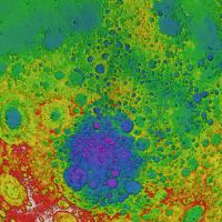
Bit of fun turning the elevation map into a coloured gradient, followed by a lighting effect (using the elevation map) - and then polar projecting the whole thing around the south pole. the result is fairly profound!
Attached thumbnail(s)
|
|
|
|
|
|
| Guest_mcgyver_* |
Nov 15 2009, 01:23 PM
Post
#85
|
|
Guests |
An italian guy here is looking for somebody able to make a 3d animation of the apollo landing sites:
http://moonscape-project.blogspot.com/2009...-moonscape.html Is anyone of you able? --------- I would like to see Kahuya data in WorldWind, but it does not run as a webstart application on my internet-connected PC, so I'd like to download it and install it on another PC: any tips about where to download an offline version? |
|
|
|
|
Nov 15 2009, 05:48 PM
Post
#86
|
|
|
Senior Member Group: Members Posts: 1582 Joined: 14-October 05 From: Vermont Member No.: 530 |
QUOTE (djellison @ Nov 14 2009, 06:25 PM) Bit of fun turning the elevation map into a coloured gradient, followed by a lighting effect (using the elevation map) - and then polar projecting the whole thing around the south pole. the result is fairly profound! Beautiful image! |
|
|
|
|
Nov 15 2009, 06:09 PM
Post
#87
|
|
|
Newbie Group: Members Posts: 2 Joined: 14-November 09 Member No.: 5043 |
QUOTE (elakdawalla @ Nov 2 2009, 12:07 AM) I just received the following from Shin-ichi Sobue at JAXA:I wish I could post some images but I'm having a bit of trouble with the Data Archive website -- got registered OK, but my searches seem to return database errors. And I couldn't seem to find my way to Terrain Camera data. Perhaps it's because my brain is somewhat mushy from a day of football and beer  But I give up for the night and give you guys the link in the hopes you can figure out how to get pretty pictures out of this website! But I give up for the night and give you guys the link in the hopes you can figure out how to get pretty pictures out of this website!I've attached the whole doc that Shin-ichi sent me, which contains a little more info about the data sets in the release. --Emily I've downloaded some data from the SELENE website for the MI instrument, I'm trying to open the IMG file but not having much luck. I've tried importing it with ERDAS, opening it with multispec, and also ImageJ. Can anyone give some pointers on getting the PDS3 IMG files to open in some software? I'm still abit new to the non earth data thing. Thanks. |
|
|
|
|
Nov 15 2009, 06:42 PM
Post
#88
|
|
|
Founder Group: Chairman Posts: 14432 Joined: 8-February 04 Member No.: 1 |
Things I try (usually in this order)
NASAView ImageJ with PDS Plugin img2png a very very large drink followed by ISIS3 |
|
|
|
|
Nov 16 2009, 07:42 AM
Post
#89
|
|
|
Member Group: Members Posts: 890 Joined: 18-November 08 Member No.: 4489 |
QUOTE I've downloaded some data from the SELENE website i was able to open them using isis3 and the " raw2isis" once i opened then in ghex to find out how big the header was pds2isis and vicar2isis failed QUOTE a very very large drink followed by ISIS3 funny , ha ha |
|
|
|
|
Nov 17 2009, 05:35 PM
Post
#90
|
|
 Senior Member Group: Moderator Posts: 3431 Joined: 11-August 04 From: USA Member No.: 98 |
Just to join the rotation movie party: Moon Globe rotation movie on YouTube.
|
|
|
|
|

|
Lo-Fi Version | Time is now: 26th April 2024 - 04:47 PM |
|
RULES AND GUIDELINES Please read the Forum Rules and Guidelines before posting. IMAGE COPYRIGHT |
OPINIONS AND MODERATION Opinions expressed on UnmannedSpaceflight.com are those of the individual posters and do not necessarily reflect the opinions of UnmannedSpaceflight.com or The Planetary Society. The all-volunteer UnmannedSpaceflight.com moderation team is wholly independent of The Planetary Society. The Planetary Society has no influence over decisions made by the UnmannedSpaceflight.com moderators. |
SUPPORT THE FORUM Unmannedspaceflight.com is funded by the Planetary Society. Please consider supporting our work and many other projects by donating to the Society or becoming a member. |
|