New map projection for Enceladus, tiger stripes in context! |

 Unmanned Spaceflight.com > Outer Solar System > Saturn > Cassini Huygens > Cassini general discussion and science results
  |
New map projection for Enceladus, tiger stripes in context! |
 Jan 13 2016, 02:47 AM Jan 13 2016, 02:47 AM
Post
#1
|
||
|
Member  Group: Members Posts: 140 Joined: 20-November 07 Member No.: 3967 |
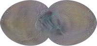
Here's a good map for contemplating tiger stripes in relation to the rest of the moon's surface (15˚ graticles).
A larger version over here
Attached thumbnail(s)
|
|
 |
 
|
|
|
Jan 13 2016, 12:13 PM
Post
#2
|
|
|
Member Group: Members Posts: 910 Joined: 4-September 06 From: Boston Member No.: 1102 |
Very nice--Thank you
-------------------- |
|
|
|
|
Mar 14 2016, 09:46 PM
Post
#3
|
|
|
Member Group: Members Posts: 140 Joined: 20-November 07 Member No.: 3967 |
An LPSC poster is now up, over here:
LPSC poster describing how this projection was conceived, and showing three additional aspects (rotated cut lines). |
|
|
|
|
Mar 15 2016, 03:35 AM
Post
#4
|
|
|
Senior Member Group: Members Posts: 1582 Joined: 14-October 05 From: Vermont Member No.: 530 |
That is very cool! Nat. Geo should just crib the whole thing and stick on one of their maps.
|
|
|
|
|
Mar 15 2016, 03:15 PM
Post
#5
|
|
 Member Group: Members Posts: 146 Joined: 22-November 14 From: Bormida (SV) - Italy Member No.: 7348 |
Really nice work, thank you.
-------------------- |
|
|
|
|
Mar 16 2016, 05:31 AM
Post
#6
|
|
|
Senior Member Group: Members Posts: 1582 Joined: 14-October 05 From: Vermont Member No.: 530 |
QUOTE (stevesliva @ Mar 14 2016, 11:35 PM)  That is very cool! Nat. Geo should just crib the whole thing and stick on one of their maps. That is to say I think it's high quality and I'd like to see it in poster form myself... not endorsing appropriation. 
|
|
|
|
|
Mar 17 2016, 12:00 AM
Post
#7
|
|
|
Member Group: Members Posts: 140 Joined: 20-November 07 Member No.: 3967 |
I've posted a high-resolution version of the above map (second row in the poster) over here:
http://rightbasicbuilding.com/2016/03/16/e...s-b-large-file/ But be sure to read the post. I'm having trouble getting it to load on-screen at full size. You'll probably have to right-click and select download linked file. Wish I knew how to fix that problem. Suggestions? EDIT: Please let me know if you download it successfully. If unable, send me a message via this forum and we'll figure out a way to FTP the file. |
|
|
|
|
Mar 17 2016, 05:16 AM
Post
#8
|
|
|
Solar System Cartographer Group: Members Posts: 10146 Joined: 5-April 05 From: Canada Member No.: 227 |
Hey Chuckles! I didn't have any problem downloading the image straight into my browser and then saving it.
See you in Houston! Phil -------------------- ... because the Solar System ain't gonna map itself.
Also to be found posting similar content on https://mastodon.social/@PhilStooke NOTE: everything created by me which I post on UMSF is considered to be in the public domain (NOT CC, public domain) |
|
|
|
|
Mar 18 2016, 03:17 AM
Post
#9
|
|
|
Member Group: Members Posts: 890 Joined: 18-November 08 Member No.: 4489 |
zero issue seeing it full size
just clicked on the image on that page in Seamonkey then for a "fit to screen size" i just right click in Seamonkey and select that , or left click the screen when i see the "minus" sign |
|
|
|
|
Mar 18 2016, 10:17 AM
Post
#10
|
|
 Senior Member Group: Members Posts: 2425 Joined: 30-January 13 From: Penang, Malaysia. Member No.: 6853 |
QUOTE (chuckclark @ Mar 17 2016, 08:00 AM) I've posted a high-resolution version of the above map (second row in the poster) over here: Wish I knew how to fix that problem. Suggestions? One possible issue could be you are using Google Chrome as a browser, Chrome has an issue with displaying some large files, (I have that issue) Try switching to another browser. This works for me.... |
|
|
|
|
Mar 18 2016, 11:01 AM
Post
#11
|
|
|
Member Group: Members Posts: 140 Joined: 20-November 07 Member No.: 3967 |
QUOTE (PaulH51 @ Mar 18 2016, 06:17 AM) using Google Chrome as a browser . . . I'm using Safari, but also happens in Firefox. I'm beginning to suspect the problem is in my machine, one of the early 27" iMacs with the 5K screen. The problem shows up when trying to open other very large files in the Safari and Firefox browsers. But oddly enough (just now try it), the file does open in Chrome! Thanks for help. c |
|
|
|
|
May 11 2016, 09:36 PM
Post
#12
|
||
|
Member Group: Members Posts: 140 Joined: 20-November 07 Member No.: 3967 |
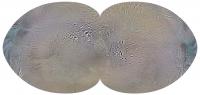
Here's the same projection, but focused on the opposite pole. And with the 0–180 meridian across the middle, left to right.
The trailing hemisphere is the top half and the leading hemisphere is the bottom half. What I'm wondering is: is there any usefulness to this view? Seems to me that if the incredibly active south pole shows up so distinctly in the first map (above, this thread), and the tiger stripes and the ring around them are due to tidal flexing, we'd see something similar happening at the north pole, where the tidal flexing stresses are presumably no different. But we don't, right? (A quick edit: this map is not exactly the same as the first one: the map boundary is slightly altered to reduce maximum shape distortion.)
Attached thumbnail(s)
|
|
|
|
|
|
|
May 12 2016, 02:57 AM
Post
#13
|
|
 Senior Member Group: Members Posts: 2530 Joined: 20-April 05 Member No.: 321 |
QUOTE (chuckclark @ May 11 2016, 02:36 PM) Seems to me [...] we'd see something similar happening at the north pole, where the tidal flexing stresses are presumably no different. It possible that the tidal flexing is symmetrical at depth, in an underlying rocky mantle, but the rising of that heat upwards is asymmetrical because, having found one outlet to the surface, a cycle of circulation began that rids much/all of the underlying levels of its heat. Think of a volcano overlying a magma pocket on Earth. It doesn't melt the entire region. It finds expression to the surface in a number of vents possibly just one and the venting there rids the entire local region of heat. In the case of Enceladus, it could be that one vent serves the entire tiny world. Mars, even, shows signs of very few locales having served as the vents for the entire planet. That's not just one region, and the regions in question aren't that small, but then Mars is a lot bigger than Enceladus. |
|
|
|
|

|
Lo-Fi Version | Time is now: 19th April 2024 - 11:31 AM |
|
RULES AND GUIDELINES Please read the Forum Rules and Guidelines before posting. IMAGE COPYRIGHT |
OPINIONS AND MODERATION Opinions expressed on UnmannedSpaceflight.com are those of the individual posters and do not necessarily reflect the opinions of UnmannedSpaceflight.com or The Planetary Society. The all-volunteer UnmannedSpaceflight.com moderation team is wholly independent of The Planetary Society. The Planetary Society has no influence over decisions made by the UnmannedSpaceflight.com moderators. |
SUPPORT THE FORUM Unmannedspaceflight.com is funded by the Planetary Society. Please consider supporting our work and many other projects by donating to the Society or becoming a member. |
|