MSL data in the PDS and the Analyst's Notebook, Working with the archived science & engineering data |

  |
MSL data in the PDS and the Analyst's Notebook, Working with the archived science & engineering data |
 Jun 1 2016, 03:02 PM Jun 1 2016, 03:02 PM
Post
#181
|
|
 Member  Group: Members Posts: 114 Joined: 19-November 14 From: Québec Member No.: 7339 |
QUOTE (sittingduck @ Jun 1 2016, 06:09 AM)  Here is one more again using Phase4's plugin, comprising 3 separate sites; one on sol 595, and two on sol 603. All have been colorized using Mastcam images. https://www.youtube.com/watch?v=WzP3Is700cY all simply magnificent sittingduck 
-------------------- |
 |
 
|
|
Jun 21 2016, 08:57 AM
Post
#182
|
|||
 Junior Member Group: Members Posts: 43 Joined: 14-December 12 Member No.: 6784 |
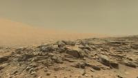
Another Mastcam colorized animation using Phase4's plugin, this time of Marias Pass.
Navcam images cover sols 991-995. The background panorama of Mt.Sharp is from Sol 1081, the nearest quality one I could find, edited to match the mid-ground with that of the Sol 99x areas. https://www.youtube.com/watch?v=7zW9yISB01Y...eature=youtu.be
Attached thumbnail(s)
|
||
|
|
|
||
|
Jun 21 2016, 10:13 AM
Post
#183
|
|
 Senior Member Group: Members Posts: 2428 Joined: 30-January 13 From: Penang, Malaysia. Member No.: 6853 |
QUOTE (sittingduck @ Jun 21 2016, 04:57 PM) Another Mastcam colorized animation using Phase4's plugin, this time of Marias Pass. Another gem  Keep up the great work Keep up the great work
|
|
|
|
|
Jul 15 2016, 07:02 PM
Post
#184
|
|||
|
Junior Member Group: Members Posts: 43 Joined: 14-December 12 Member No.: 6784 |
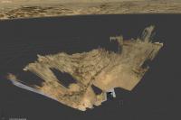
I have finished another video animation of a location in Gale crater; this time Yellowknife Bay on sol 133-137.
https://www.youtube.com/watch?v=94giGbUAsJw
Attached thumbnail(s)
|
||
|
|
|
||
|
Jul 15 2016, 08:50 PM
Post
#185
|
|
|
Junior Member Group: Members Posts: 22 Joined: 9-December 10 Member No.: 5551 |
Wow great !
|
|
|
|
|
Jul 15 2016, 10:08 PM
Post
#186
|
|
|
Member Group: Members Posts: 923 Joined: 10-November 15 Member No.: 7837 |
This is so impressive Sittingduck, thanks for sharing! Would you consider rendering in 3D? ( SBS or OU )
I'd also love some insight into the process of mapping the Mastcam imagery to Navcam meshes...is it a case of manually assigning the Mastcam images to Navcam texture? -------------------- |
|
|
|
|
Jul 15 2016, 10:43 PM
Post
#187
|
|
|
Junior Member Group: Members Posts: 43 Joined: 14-December 12 Member No.: 6784 |
QUOTE (Sean @ Jul 16 2016, 12:08 AM) This is so impressive Sittingduck, thanks for sharing! Would you consider rendering in 3D? ( SBS or OU ) I'd also love some insight into the process of mapping the Mastcam imagery to Navcam meshes...is it a case of manually assigning the Mastcam images to Navcam texture? Thanks. Yes I will try a 3D render, also stereo-anaglyph. To get the colored terrain I first stitch together the mastcam images that coincide with a navcam mesh. Then I use photoshop to manually warp the mastcam panorama onto the navcam texture that comes along with the mesh. It is a bit tedious. Often there is no color coverage or the color pictures cover only a fraction of the entire mesh. With Yellowknife Bay, color coverage of the meshes was virtually complete. |
|
|
|
|
Jul 15 2016, 11:07 PM
Post
#188
|
|
|
Member Group: Members Posts: 923 Joined: 10-November 15 Member No.: 7837 |
Manual warping is a lot of work. I've been down that rabbit hole...but in this case the results are worth it!
-------------------- |
|
|
|
|
Jul 15 2016, 11:14 PM
Post
#189
|
|
 Senior Member Group: Members Posts: 1628 Joined: 5-March 05 From: Boulder, CO Member No.: 184 |
These are the most impressive 3D animations I've yet seen. I wonder if any associated 3D model data files might be available for VR viewing?
-------------------- Steve [ my home page and planetary maps page ]
|
|
|
|
|
Jul 17 2016, 01:49 PM
Post
#190
|
|
|
Senior Member Group: Members Posts: 1628 Joined: 5-March 05 From: Boulder, CO Member No.: 184 |
Here is a nice interface that eyes.nasa.gov has. This might have potential to also add the ground based images (and photogrammetry) as 3D information.
http://eyes.nasa.gov/curiosity/ -------------------- Steve [ my home page and planetary maps page ]
|
|
|
|
|
Jul 22 2016, 09:37 PM
Post
#191
|
|
 Senior Member Group: Moderator Posts: 3431 Joined: 11-August 04 From: USA Member No.: 98 |
Amazing work, sittingduck. (And thanks for the thanks.)
|
|
|
|
|
Jul 23 2016, 12:33 PM
Post
#192
|
|
|
Junior Member Group: Members Posts: 22 Joined: 9-December 10 Member No.: 5551 |
Hello,
It's possible to create a 3d stereoscopic version ? In full SBS (3840x1080) @ 48fps or 60fps ? |
|
|
|
|
Jul 26 2016, 05:31 PM
Post
#193
|
|
|
Member Group: Members Posts: 923 Joined: 10-November 15 Member No.: 7837 |
Here is a preview of a short film I'm putting together of Curi traversing Naukluft plateau...
 ...building on previous shots, this time blending a spherical 360 Mastcam photomosaic mapped to HiRISE orbital data of the equivalent terrain which enables a model of Curi to be 'driven' through the scene. This shot uses a panorama from Sol 1282. Final version uses 4 pano's covering the 100 Sol traverse ( 1267 to 1367 ) I took liberties with the route, Curi's method of driving and most obviously the speed limit! I really wanted to see Curi move through the landscape, so this idea is more about appreciating the environment and using Curi as a contextual cue with which to view the scene afresh. Almost every aspect of this production is subject to change and/or improvement so hopefully the finished article will feel slightly less cartoony. -------------------- |
|
|
|
|
Aug 1 2016, 10:28 PM
Post
#194
|
|
|
Senior Member Group: Members Posts: 2428 Joined: 30-January 13 From: Penang, Malaysia. Member No.: 6853 |
Mars Science Laboratory Release 12
The NASA Planetary Data System announces the twelfth release of data from the Mars Science Laboratory (MSL) mission, covering data acquired from Sol 1160 through Sol 1293 (November 10, 2015, to March 27, 2016). This release consists of raw and derived data sets from the following instruments: Alpha Particle X-ray Spectrometer (APXS) Chemistry & Micro-Imaging (ChemCam) Chemistry and Mineralogy (CheMin) Dynamic Albedo of Neutrons (DAN) Hazard Avoidance Cameras (Hazcam) Mars Hand Lens Imager (MAHLI) Mars Descent Imager (MARDI) Mast-mounted Cameras (Mastcam) Navigation Cameras (Navcam) Position Localization and Attitude Correction Estimate Storage (PLACES) Radiation Assessment Detector (RAD) Rover Environmental Monitoring Station (REMS) Sample Analysis at Mars (SAM) Spacecraft, Planet, Instrument, Pointing C-Matrix, and Event kernels (SPICE) To access the above data for this release: https://pds.nasa.gov/tools/subscription_ser...-20160801.shtml |
|
|
|
|
Dec 5 2016, 11:42 PM
Post
#195
|
|
|
Senior Member Group: Members Posts: 2428 Joined: 30-January 13 From: Penang, Malaysia. Member No.: 6853 |
Mars Science Laboratory Release 13
The NASA Planetary Data System announces the thirteenth release of data from the Mars Science Laboratory (MSL) mission, covering data acquired from Sol 1294 through Sol 1417 (March 27, 2016, to August 1, 2016). This release consists of raw and derived data sets from the following instruments: Alpha Particle X-ray Spectrometer (APXS) Chemistry & Micro-Imaging (ChemCam) Chemistry and Mineralogy (CheMin) Dynamic Albedo of Neutrons (DAN) Hazard Avoidance Cameras (Hazcam) Mars Hand Lens Imager (MAHLI) Mars Descent Imager (MARDI) Mast-mounted Cameras (Mastcam) Navigation Cameras (Navcam) Position Localization and Attitude Correction Estimate Storage (PLACES) Radiation Assessment Detector (RAD) Rover Environmental Monitoring Station (REMS) Sample Analysis at Mars (SAM) Spacecraft, Planet, Instrument, Pointing C-Matrix, and Event kernels (SPICE) To access the above data for this release: https://pds.nasa.gov/tools/subscription_ser...-20161205.shtml |
|
|
|
|

|
Lo-Fi Version | Time is now: 24th April 2024 - 04:53 PM |
|
RULES AND GUIDELINES Please read the Forum Rules and Guidelines before posting. IMAGE COPYRIGHT |
OPINIONS AND MODERATION Opinions expressed on UnmannedSpaceflight.com are those of the individual posters and do not necessarily reflect the opinions of UnmannedSpaceflight.com or The Planetary Society. The all-volunteer UnmannedSpaceflight.com moderation team is wholly independent of The Planetary Society. The Planetary Society has no influence over decisions made by the UnmannedSpaceflight.com moderators. |
SUPPORT THE FORUM Unmannedspaceflight.com is funded by the Planetary Society. Please consider supporting our work and many other projects by donating to the Society or becoming a member. |
|