Traverse to the Delta, sols 379-414, 15 Mar 2022- 21 Apr 2022 |

  |
Traverse to the Delta, sols 379-414, 15 Mar 2022- 21 Apr 2022 |
 Mar 26 2022, 12:50 AM Mar 26 2022, 12:50 AM
Post
#31
|
|
|
Member  Group: Members Posts: 401 Joined: 5-January 07 From: Manchester England Member No.: 1563 |
QUOTE (Ant103 @ Mar 25 2022, 05:57 PM)  Sol 386 Navcam panoramic. A special one because THEY TOOK THE SKY, again... Stunning, thank you for sharing! -------------------- |
 |
 
|
|
Mar 27 2022, 10:29 AM
Post
#32
|
||
 Member Group: Members Posts: 790 Joined: 9-May 21 From: Germany Member No.: 9017 |
Sol 382 Mastcam-Z filters 1 to 6 multispectral principal components false-color panorama
|
|
|
|
|
|
|
Mar 27 2022, 11:21 AM
Post
#33
|
|
 Senior Member Group: Members Posts: 1619 Joined: 12-February 06 From: Bergerac - FR Member No.: 678 |
Sol 389 Navcam panoramic. We roving close to a little unnamed crater.
-------------------- |
|
|
|
|
Mar 30 2022, 07:39 AM
Post
#34
|
|
 Member Group: Members Posts: 648 Joined: 9-May 05 From: Subotica Member No.: 384 |
Is there a reason for this pause in releasing raw images from Mars2020 that I am unaware of? The last raw image was from sol 389 and now it's sol 394. Is there some software update going on or what? I even tried to look on social media sites and there is not a single word about it.
I can still remember MER Spirit and its LOS in the first few sols on Mars, and I hope it is nothing like that this time? -------------------- The scientist does not study nature because it is useful; he studies it because he delights in it, and he delights in it because it is beautiful.
Jules H. Poincare My "Astrophotos" gallery on flickr... |
|
|
|
|
Mar 30 2022, 06:04 PM
Post
#35
|
|
|
Solar System Cartographer Group: Members Posts: 10229 Joined: 5-April 05 From: Canada Member No.: 227 |
No public information at the moment. Sol 394 images just came down.
Phil -------------------- ... because the Solar System ain't gonna map itself.
Also to be found posting similar content on https://mastodon.social/@PhilStooke Maps for download (free PDF: https://upload.wikimedia.org/wikipedia/comm...Cartography.pdf NOTE: everything created by me which I post on UMSF is considered to be in the public domain (NOT CC, public domain) |
|
|
|
|
Mar 30 2022, 10:35 PM
Post
#36
|
||
|
Solar System Cartographer Group: Members Posts: 10229 Joined: 5-April 05 From: Canada Member No.: 227 |
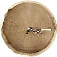
And here is the panorama for sol 394 in circular form.
Phil
-------------------- ... because the Solar System ain't gonna map itself.
Also to be found posting similar content on https://mastodon.social/@PhilStooke Maps for download (free PDF: https://upload.wikimedia.org/wikipedia/comm...Cartography.pdf NOTE: everything created by me which I post on UMSF is considered to be in the public domain (NOT CC, public domain) |
|
|
|
|
|
|
Mar 31 2022, 12:56 PM
Post
#37
|
|
|
Member Group: Members Posts: 240 Joined: 18-July 06 Member No.: 981 |
[quote name='Phil Stooke' date='Mar 30 2022, 11:35 PM' post='256699']
And here is the panorama for sol 394 in circular form. Phil Phil thanks as always for the amazing work you do for us all. What is a good way to view these circular pans? Do you use viewing software that rotates the image through 360 degrees? Mark |
|
|
|
|
Mar 31 2022, 02:57 PM
Post
#38
|
|||
|
Member Group: Members Posts: 790 Joined: 9-May 21 From: Germany Member No.: 9017 |
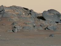
Sol 385 Mastcam-Z
What could that bright thing on La Orotava crater wall be? A piece of hardware lost or dropped during descent and landing? A piece of Martian rock that was hurled here from elsewhere by a meteorite impact? A meteorite? It doesn't look like a meteorite.
|
||
|
|
|
||
|
Mar 31 2022, 04:58 PM
Post
#39
|
|
|
Member Group: Members Posts: 923 Joined: 10-November 15 Member No.: 7837 |
Some enhanced / extended sky shots from the MZL_00388 panorama...
      
-------------------- |
|
|
|
|
Mar 31 2022, 05:00 PM
Post
#40
|
|
 Member Group: Members Posts: 684 Joined: 24-July 15 Member No.: 7619 |
QUOTE (tau) A piece of hardware lost or dropped during descent and landing? Nope. Too big.QUOTE (tau) A meteorite? Nope. Shape and how it seems to 'fit' against a back rock suggests in situ.QUOTE (tau) A piece of Martian rock that was hurled here from elsewhere by a meteorite impact? Eh, perhaps, but as above, based on what appears to be a 'fit' to the rock behind, it would have to be hurled, buried, then excavated.QUOTE (tau) What could that bright thing on La Orotava crater wall be? My initial guess would be a pegmatite pipe.When molten rock cools, the result is much like leaving a soda or beer in the freezer too long, aka "apple jack" (early distillers let hard cider freeze out the water, then poured out the concentrated liquor)* When molten rock chambers cool, they 'freeze out' minerals which snow down, until you're left with a magma enriched in the material with the lowest freezing point- which is usually enriched in metals, often white, and called "pegmatite". *disclaimer- don't try at home. Freeze distillation doesn't separate methanol (bad-go blind) from ethanol (good, you've made apple brandy/schnapps). To separate methanol from ethanol, you need heat distillation and condensation (e.g. a moonshine still) |
|
|
|
|
Mar 31 2022, 05:59 PM
Post
#41
|
|
|
Senior Member Group: Members Posts: 1592 Joined: 14-October 05 From: Vermont Member No.: 530 |
QUOTE When molten rock chambers cool, they 'freeze out' minerals which snow down, We recently got a cider press, but tis the season for: the mineral "sand" aka niter that precipitates from cooling maple syrup. (We pulled our 10 taps after getting about 120gallons of sap.) Cider is a fall thing. You can watch it snow niter, but I think you're seeing sugar on a tiny bit of unspecified "mineral." I'm not sure. |
|
|
|
|
Mar 31 2022, 07:38 PM
Post
#42
|
||
|
Member Group: Members Posts: 790 Joined: 9-May 21 From: Germany Member No.: 9017 |
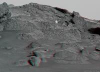
Sol 385 Mastcam-Z right eye filter 0 (RGB), principal components false colors
Landscape with rock garden on the crater wall of La Orotava The false-color bluish gray of the rocks varies a bit: in vesicular rocks it tends towards violet, in layered rocks towards turquoise.
|
|
|
|
|
|
|
Mar 31 2022, 10:47 PM
Post
#43
|
|
|
Senior Member Group: Members Posts: 1057 Joined: 17-February 09 Member No.: 4605 |
QUOTE (tau @ Mar 31 2022, 02:57 PM) Sol 385 Mastcam-Z What could that bright thing on La Orotava crater wall be? A piece of Martian rock that was hurled here from elsewhere by a meteorite impact? Ejecta yes, but being situated on the crater wall probably home grown. With Séítah seemingly the remnant of a lava lake or magma chamber, fractional crystallization would have resulted in layering of olivine, plagioclase feldspar etc and the impact may have breached that level. One thing about the crater. Did it impact the boundary of Séítah before the crater floor was covered by lava, embaying the crater wall or after? Given that the Séítah side seems much more eroded I would punt for after. |
|
|
|
|
Apr 1 2022, 03:26 AM
Post
#44
|
||
|
Solar System Cartographer Group: Members Posts: 10229 Joined: 5-April 05 From: Canada Member No.: 227 |
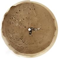
Here is the sol 395 panorama in circular form. Up on top of a little ridge.
Mark, I don't have special viewing software. The images are made and viewed in Photoshop. I use these images to compare with a HiRISE image to find locations or identify features> So I just view it as a flat image and compare it with another flat image. I suppose there might be other ways to view this but I'm not clever enough to do that. Phil
-------------------- ... because the Solar System ain't gonna map itself.
Also to be found posting similar content on https://mastodon.social/@PhilStooke Maps for download (free PDF: https://upload.wikimedia.org/wikipedia/comm...Cartography.pdf NOTE: everything created by me which I post on UMSF is considered to be in the public domain (NOT CC, public domain) |
|
|
|
|
|
|
Apr 1 2022, 03:26 AM
Post
#45
|
|
|
Senior Member Group: Members Posts: 3009 Joined: 30-October 04 Member No.: 105 |
My take is that it is a piece of ejecta from the fabled Whiterock Formation.
--Bill -------------------- |
|
|
|
|

|
Lo-Fi Version | Time is now: 27th September 2024 - 08:20 AM |
|
RULES AND GUIDELINES Please read the Forum Rules and Guidelines before posting. IMAGE COPYRIGHT |
OPINIONS AND MODERATION Opinions expressed on UnmannedSpaceflight.com are those of the individual posters and do not necessarily reflect the opinions of UnmannedSpaceflight.com or The Planetary Society. The all-volunteer UnmannedSpaceflight.com moderation team is wholly independent of The Planetary Society. The Planetary Society has no influence over decisions made by the UnmannedSpaceflight.com moderators. |
SUPPORT THE FORUM Unmannedspaceflight.com is funded by the Planetary Society. Please consider supporting our work and many other projects by donating to the Society or becoming a member. |
|