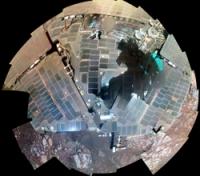
Winter campaign at Cook Haven, Sol 3512 - 3599 (December 13, 2013 - March 10, 2014) |

  |
Winter campaign at Cook Haven, Sol 3512 - 3599 (December 13, 2013 - March 10, 2014) |
 Dec 30 2013, 08:47 PM Dec 30 2013, 08:47 PM
Post
#16
|
||
 Senior Member  Group: Members Posts: 4246 Joined: 17-January 05 Member No.: 152 |
QUOTE (jvandriel @ Dec 19 2013, 10:30 AM)  The Dust Devil on Sol 3514. Here's a stretched difference of the (smoothed) 3514 and 3520 frames:
By matching features with an orbital view, I estimate the dd's distance as 2.9 km. That translates into a height of at least 230 metres. Since the dd extends to the top of the frame it is likely a fair bit taller than that. (You could estimate the full height from the length of the dark streak to its right, assuming that is its shadow.) |
|
 |
 
|
|
|
Jan 4 2014, 04:01 AM
Post
#17
|
|
|
Senior Member Group: Members Posts: 4246 Joined: 17-January 05 Member No.: 152 |
Oppy's up to 371 Whr now. Recently she was 100 Whr below this level, and 371 is pretty high for this time of year. I wouldn't be surprized if levels like this mean more driving flexibility.
|
|
|
|
|
Jan 7 2014, 03:28 PM
Post
#18
|
|||
|
Solar System Cartographer Group: Members Posts: 10151 Joined: 5-April 05 From: Canada Member No.: 227 |
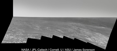
The big panorama being created now includes the best view yet of Cape York from this area. Here is a composite of two frames:
and a 3x stretch to help interpret it. The distant horizon ridge would run up to the Santa Maria area.
Phil -------------------- ... because the Solar System ain't gonna map itself.
Also to be found posting similar content on https://mastodon.social/@PhilStooke Maps for download (free PD: https://upload.wikimedia.org/wikipedia/comm...Cartography.pdf NOTE: everything created by me which I post on UMSF is considered to be in the public domain (NOT CC, public domain) |
||
|
|
|
||
|
Jan 7 2014, 04:41 PM
Post
#19
|
|
|
Senior Member Group: Members Posts: 4246 Joined: 17-January 05 Member No.: 152 |
Thanks for those, Phil. I can't wait to see this anniversary sequence in colour...
We haven't been to the distant ridge behind CY, but I see what you mean by it running to Santa Maria. But we were in the direction of this frame, where we can also now see a distant ridge: http://qt.exploratorium.edu/mars/opportuni...2M1.JPG?sol3539 This frame (more accurately the left side of the frame) is looking roughly towards where we made our big turn east after heading south from Victoria. I mentioned recently that our first sighting of Solander was around sol 2269 - that's also at the turn to the east. So we may now be seeing our route across the plains (though that depends how far away that distant ridge is). |
|
|
|
|
Jan 7 2014, 06:32 PM
Post
#20
|
|
 Junior Member Group: Members Posts: 40 Joined: 29-December 11 Member No.: 6295 |
-------------------- But to be a lament on the lips of the loved one is glorious, For the prosaic goes toneless to Orcus below. (Friedrich Schiller: Naenie)
Home of marspages.eu and plutoidenpages.eu |
|
|
|
|
Jan 8 2014, 06:41 PM
Post
#21
|
|
|
Senior Member Group: Moderator Posts: 4279 Joined: 19-April 05 From: .br at .es Member No.: 253 |
Here's the last MER Update by A.J.S. Rayl, containing a lot of goodies as usual.
I just would like to highlight a few details about the winter campaign and future plans after this season. QUOTE Now that the rover is employing the lily pad strategy on Murray Ridge, "this winter for Opportunity will probably be like Spirit's first winter at Husband Hill," Stroupe said. That means, barring any unforeseen untoward event, the rover will continue to rove, lily pad to lily pad, and work throughout the harsh season. QUOTE The scientists have already spotted "a field geologist's dream," as Arvidson calls it, some 600 meters further south.
"It's a beautiful stratigraphic section of crust that's exposed on the western side of Endeavour's rim," said Arvidson. "You can walk up and down through time and along time following the outcrop." |
|
|
|
|
Jan 8 2014, 07:45 PM
Post
#22
|
|
 Senior Member Group: Admin Posts: 4763 Joined: 15-March 05 From: Glendale, AZ Member No.: 197 |
QUOTE (Phil Stooke @ Jan 7 2014, 07:28 AM) The big panorama being created now includes the best view yet of Cape York from this area. Here is a composite of two frames: Thanks Phil. That perspective really highlights the how and why of the illusion we were all ensnared by a couple years ago where Cape York seemed to be a vertical-rising peak from the overhead HIRISE images. -------------------- If Occam had heard my theory, things would be very different now.
|
|
|
|
|
Jan 9 2014, 09:04 AM
Post
#23
|
|
 Member Group: Members Posts: 691 Joined: 21-December 07 From: Clatskanie, Oregon Member No.: 3988 |
I wasn't going to post this and just wait until the color images came down, but here ya go. More to come.
|
|
|
|
|
Jan 11 2014, 01:21 AM
Post
#24
|
|||
|
Member Group: Members Posts: 866 Joined: 15-March 05 From: Santa Cruz, CA Member No.: 196 |
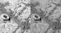
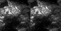
x-eyes of that amusing 'lil chunkster and stereo MI on SOL3541 reminds me of a rock I collected as a child in a volcanic steam vent in Hawaii.
|
||
|
|
|
||
|
Jan 11 2014, 02:11 AM
Post
#25
|
|
 Senior Member Group: Moderator Posts: 3431 Joined: 11-August 04 From: USA Member No.: 98 |
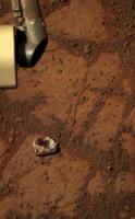
Wondering where 'Pinnacle Island' came from? So was I; well, I still am. But it looks like it appeared between Sols 3536 and 3540. So in other words, it probably appeared during the turn on Sol 3540. Neat, huh?
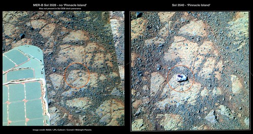 MERBSol3528-3540PinnacleIslandComparison on Flickr |
|
|
|
|
Jan 11 2014, 02:15 AM
Post
#26
|
||
|
Founder Group: Chairman Posts: 14432 Joined: 8-February 04 Member No.: 1 |
Fascinating little rock - totally different to the bedrock beneath
Attached thumbnail(s)
|
|
|
|
|
|
|
Jan 11 2014, 03:20 AM
Post
#27
|
|
|
Senior Member Group: Moderator Posts: 3431 Joined: 11-August 04 From: USA Member No.: 98 |
It looks different from the bedrock underneath, but is it? Looking at the bottom edge in particular, I could almost image it's a piece of bedrock that was broken off and flipped over.
Edit: Actually, I figured out what it reminds me of, a bit. Snake River. (Insert standard 'I'm not a geologist' disclaimer.) |
|
|
|
|
Jan 11 2014, 05:04 AM
Post
#28
|
|
|
Member Group: Members Posts: 691 Joined: 21-December 07 From: Clatskanie, Oregon Member No.: 3988 |
Or "Tintina".
http://mars.nasa.gov/msl/multimedia/images/?ImageID=5145 But of coarse what we are seeing may or may not be similar materials. |
|
|
|
|
Jan 11 2014, 06:21 AM
Post
#29
|
|
|
Senior Member Group: Moderator Posts: 3431 Joined: 11-August 04 From: USA Member No.: 98 |
I think 'Tintina' was just the name for part of 'Snake River' that got broken off.
|
|
|
|
|
Jan 11 2014, 08:41 AM
Post
#30
|
|
 Member Group: Members Posts: 404 Joined: 5-January 10 Member No.: 5161 |
QUOTE (mhoward @ Jan 10 2014, 06:11 PM) ...it looks like it appeared between Sols 3536 and 3540...? This rock must have popped out pretty far from under the rover's weight. A new record! |
|
|
|
|

|
Lo-Fi Version | Time is now: 25th April 2024 - 11:51 AM |
|
RULES AND GUIDELINES Please read the Forum Rules and Guidelines before posting. IMAGE COPYRIGHT |
OPINIONS AND MODERATION Opinions expressed on UnmannedSpaceflight.com are those of the individual posters and do not necessarily reflect the opinions of UnmannedSpaceflight.com or The Planetary Society. The all-volunteer UnmannedSpaceflight.com moderation team is wholly independent of The Planetary Society. The Planetary Society has no influence over decisions made by the UnmannedSpaceflight.com moderators. |
SUPPORT THE FORUM Unmannedspaceflight.com is funded by the Planetary Society. Please consider supporting our work and many other projects by donating to the Society or becoming a member. |
|