Sol 462 Navcam Pan, 15 frame panorama by Autostitch 3.1 meg |

  |
Sol 462 Navcam Pan, 15 frame panorama by Autostitch 3.1 meg |
 May 10 2005, 01:10 PM May 10 2005, 01:10 PM
Post
#16
|
||
|
Solar System Cartographer  Group: Members Posts: 10159 Joined: 5-April 05 From: Canada Member No.: 227 |
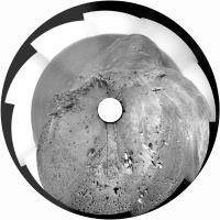
Here is a polar version of jvandriel's pan from just east of Methuselah and Jibsheet. Thanks, jvandriel! This is quite good for showing the tracks and tracing the route.
It's common to say that the hill to the north is Clark Hill. But I think that the hill forming the horizon is really Chawla Hill, with Clark Hill in front of it and a bit lower. The top edge of Clark Hill is made visible by a line of dark rocks... is this another outcrop like Methuselah and Larry's Lookout? Phil
-------------------- ... because the Solar System ain't gonna map itself.
Also to be found posting similar content on https://mastodon.social/@PhilStooke Maps for download (free PD: https://upload.wikimedia.org/wikipedia/comm...Cartography.pdf NOTE: everything created by me which I post on UMSF is considered to be in the public domain (NOT CC, public domain) |
|
 |
 
|
|
|
May 10 2005, 06:09 PM
Post
#17
|
||
|
Member Group: Members Posts: 688 Joined: 20-April 05 From: Sweden Member No.: 273 |
QUOTE (Phil Stooke @ May 10 2005, 03:10 PM) Here is a polar version of jvandriel's pan from just east of Methuselah and Jibsheet. Thanks, jvandriel! This is quite good for showing the tracks and tracing the route. It's common to say that the hill to the north is Clark Hill. But I think that the hill forming the horizon is really Chawla Hill, with Clark Hill in front of it and a bit lower. The top edge of Clark Hill is made visible by a line of dark rocks... is this another outcrop like Methuselah and Larry's Lookout? Phil
 I think it might actually be part of the same hard layer as Methuselah. You can see that the hills have a rather clear cuesta morphology (caused by an inclined hard layer). There also seems to be similar harder layers visible in the hills on the other side of Tennessee valley. This whole section of Columbia hills seems to have been shaped by differential erosion of an inclined sediment pack. |
|
|
|
|
|
|
May 10 2005, 06:35 PM
Post
#18
|
||
 Senior Member Group: Members Posts: 3419 Joined: 9-February 04 From: Minneapolis, MN, USA Member No.: 15 |
QUOTE (tty @ May 10 2005, 01:09 PM) QUOTE (Phil Stooke @ May 10 2005, 03:10 PM) Here is a polar version of jvandriel's pan from just east of Methuselah and Jibsheet. Thanks, jvandriel! This is quite good for showing the tracks and tracing the route. It's common to say that the hill to the north is Clark Hill. But I think that the hill forming the horizon is really Chawla Hill, with Clark Hill in front of it and a bit lower. The top edge of Clark Hill is made visible by a line of dark rocks... is this another outcrop like Methuselah and Larry's Lookout? Phil
I think it might actually be part of the same hard layer as Methuselah. You can see that the hills have a rather clear cuesta morphology (caused by an inclined hard layer). There also seems to be similar harder layers visible in the hills on the other side of Tennessee valley. This whole section of Columbia hills seems to have been shaped by differential erosion of an inclined sediment pack. See, this is why I think the hills are *not* composed of the original crater floor, uplifted by faulting. The floor of Gusev would have been a melt sheet covering a highly shocked and probably brecciated underfloor. Methuselah looks like sandstone -- whether deposited by wind or water, it's some type of layered sandstone. Which is why I'm convinced that Gusev developed a nice thick floor of layered sediments on top of the melt sheet before the upthrust fault created the hills, which was then followed by one or more lava inundations. And the larger-scale landforms (the "feed river" formation and delta landforms on the floor) would suggest that the layered sediments were water-laid. I don't insist that the sediments *must* have been water-laid, but I think the evidence is pointing to that conclusion... -the other Doug -------------------- The trouble ain't that there is too many fools, but that the lightning ain't distributed right. -Mark Twain
|
|
|
|
|
|
|
May 11 2005, 09:04 AM
Post
#19
|
|
|
Senior Member Group: Members Posts: 2823 Joined: 22-April 05 From: Ridderkerk, Netherlands Member No.: 353 |
QUOTE (dilo @ May 10 2005, 05:52 AM) QUOTE (jvandriel @ May 9 2005, 08:56 AM) and also a last nav cam view of Methuselah on sol 477 taken with the left Nav Cam. jvandriel Great job, Jvandriel. I posted a false color version of Pan Cam panorma in the Methuselah thread, but without the two lower frames... your Nav Cam stitch is a perfect "context" image for it! Which stitch program are you using? - regards Dilo, for stitching I use autostitch ( www.autostich.net/ ). A great free program. It does the stitching completely automatic. You can change the parameters for better results. Visit their website. ( see above ) Best regards jvandriel |
|
|
|
|

|
Lo-Fi Version | Time is now: 6th May 2024 - 08:33 AM |
|
RULES AND GUIDELINES Please read the Forum Rules and Guidelines before posting. IMAGE COPYRIGHT |
OPINIONS AND MODERATION Opinions expressed on UnmannedSpaceflight.com are those of the individual posters and do not necessarily reflect the opinions of UnmannedSpaceflight.com or The Planetary Society. The all-volunteer UnmannedSpaceflight.com moderation team is wholly independent of The Planetary Society. The Planetary Society has no influence over decisions made by the UnmannedSpaceflight.com moderators. |
SUPPORT THE FORUM Unmannedspaceflight.com is funded by the Planetary Society. Please consider supporting our work and many other projects by donating to the Society or becoming a member. |
|