Printable Version of Topic
Click here to view this topic in its original format
Unmanned Spaceflight.com _ MSL _ Exploring Mt Sharp - The Dunes - Part 1: Bagnold Dunes
Posted by: PaulH51 Nov 23 2015, 12:41 PM
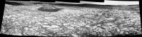
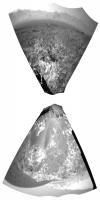
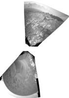
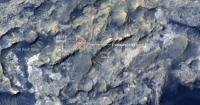
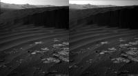
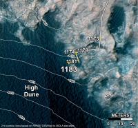
Midnight Planets reporting that Curiosity moved approximately 46.2m SSE (161º) on Sol 1172. http://www.midnightplanets.com/web/MSL/sol/01172.html Quick and Dirty L-NavCam using the 5 available frames (MS ICE), reduced ~10% to get within the UL limit
|
Posted by: centsworth_II Nov 23 2015, 09:12 PM

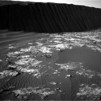
El Dorado is a patch of sand covered with ripples and the Bagnold dunes are slowly moving (wind driven) hills of sand, also covered with ripples.
|
http://www.jpl.nasa.gov/news/news.php?feature=4772
http://onlinelibrary.wiley.com/doi/10.1029/2008JE003101/full
Posted by: PaulH51 Nov 23 2015, 10:54 PM
Mission Update from Lauren Edgar - Sol 1173: Dune monitoring http://astrogeology.usgs.gov/news/astrogeology/sol-1173-dune-monitoring
Posted by: charborob Nov 24 2015, 01:16 PM
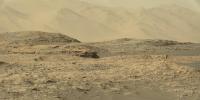
Sol 1172 Lmastcam view of the "mini-dustbowl":
|
|
Posted by: Phil Stooke Nov 24 2015, 02:40 PM
Today's (sol 1173's) Hazcams reprojected to get the location I put on the map:
|
Phil
Posted by: jvandriel Nov 24 2015, 04:00 PM
The Navcam L view on Sol 1172.
Jan van Driel
|
|
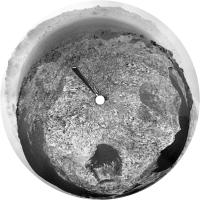
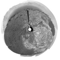
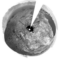
Posted by: Phil Stooke Nov 24 2015, 09:19 PM
A very nice view. Here it is projected into a circle.
Phil
|
Posted by: PaulH51 Nov 25 2015, 08:24 AM
Sol 1173: L-NavCam (17 frames) Quick and Dirty in MS ICE, complete with some bad stitching errors, but it should give an idea of the local terrain until others can post a better version 
https://www.flickr.com/photos/105796482@N04/23185612232/sizes/l/
Flickr Original Size 8192 x 1833 pixels https://www.flickr.com/photos/105796482@N04/23185612232/sizes/o/
Imgur http://i.imgur.com/7m8kimr.jpg
Posted by: jvandriel Nov 25 2015, 11:01 AM
The complete Navcam L view on Sol 1173.
Jan van Driel
|
|
Posted by: Phil Stooke Nov 25 2015, 03:31 PM
A quick hazcam reprojection to find the sol 1174 location.
Phil
|
Posted by: Herobrine Nov 25 2015, 04:05 PM
NAVCAM travel animation for Sol 1172 is 47 frames.
Here's a small preview of the left NAVCAM's view.
And here is the full-size stereo pair animation for http://i.imgur.com/FvFZdMq.gif and http://i.imgur.com/44t5hmh.gif viewing. File sizes are 7.2 MiB each.
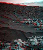
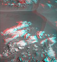
Posted by: atomoid Nov 25 2015, 09:34 PM
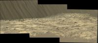
stunning imagery from sol1173 http://www.midnightplanets.com/web/MSL/image/01173/1173MR0053170010602294E01_DXXX.html including some big ripples descending the far crater rim foothills i've never noticed before.
|
|
|
Posted by: PaulH51 Nov 26 2015, 12:04 AM
Really interesting far off ripples, and great red/cyan anaglyphs, thanks Atomoid...
Mission Update from Lauren Edgar - Sols 1177-1179: 'Recipe for a successful rover plan' http://astrogeology.usgs.gov/news/astrogeology/sols-1177-1179-recipe-for-a-successful-rover-plan
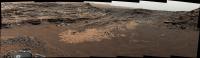
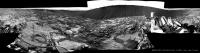
Today science and engineering teams cooked up a full 3-sol plan, to account for the second half of the Thanksgiving holiday weekend. The team started with equal parts Mastcam and ChemCam to analyze the sand and bedrock, and to monitor the movement of sand across the rover deck and in nearby ripples. The meat of the plan consists of SAM preconditioning, drop off of the Greenhorn drill sample to SAM, and an EGA (evolved gas analysis). Essentially that means that well heat the sample up in an oven and measure the major gases that are released. Since this is a very power intensive activity, we kept the sides to a minimum. On the third sol we planned a healthy dose of MAHLI wheel imaging to monitor wear and tear. We also added in a handful of post-drive imaging activities since the wheel imaging requires us to move slightly and we want to have updated information for targeting. And we squeezed in an additional Mastcam change detection experiment to monitor the ripples on the third sol. Sprinkled throughout the plan are our standard RAD and REMS and DAN measurements. Add in a dash of excitement about the opportunity to study active dunes on another planet, and its sure to be a great weekend on Mars.
Posted by: Phil Stooke Nov 26 2015, 12:43 AM
Damia Bouic has posted another panorama here:
http://www.db-prods.net/marsroversimages/curiosity-2014.html#111
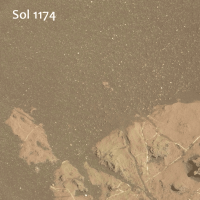
It is for sol 1174. Here is a circular version of it, showing the surroundings in a map-like format.
Phil
|
Posted by: jvandriel Nov 26 2015, 10:06 AM
Here is my view of the Sol 1174 Navcam L panorama.
Jan van Driel.

|
Posted by: PaulH51 Nov 26 2015, 12:33 PM
sol 1173: 4 frames from the R-MastCam, MS ICE, some interesting ripple like features, eroded channels? Left of center on the distant crater rim wall. Colours somewhat over processed as I was trying to remove a stubborn green cast.
https://www.flickr.com/photos/105796482@N04/23023607660/sizes/l/
Flicker Original size (2392 x 2256) http://www.flickr.com/photos/105796482@N04/23023607660/sizes/o
Imgur http://i.imgur.com/miRFfs9.jpg
Posted by: neo56 Nov 26 2015, 09:08 PM
My take on these recent panoramas of dunes and mountains:
https://www.flickr.com/photos/105035663@N07/22702500034/sizes/k/
https://www.flickr.com/photos/105035663@N07/23248392661/sizes/k/
https://www.flickr.com/photos/105035663@N07/23331209065/sizes/k/
Posted by: PaulH51 Nov 27 2015, 12:50 AM
Meanwhile: Let me share this wallpaper of Dune 2 @Bagnold (2560 x 1080 pixels)
It comes with an extended sky, which I think really makes the NavCam's pop. Parts of Mount Sharp from Sol 1169 were used to fill out the horizon.
From the stitching alone you can see that it's not my work, but from someone who has applied for membership here at UMSF. Hopefully that application will be processed soon, so we can see more of these images.
|
Imgur: http://i.imgur.com/VK79Uz2.jpg
Posted by: neo56 Nov 27 2015, 07:15 PM
Another view of the wall of Gale crater, this time looking west:
https://www.flickr.com/photos/105035663@N07/23270040311/sizes/k/
And with contrast increased to highlight gully-like features on the side of the mountains:
https://www.flickr.com/photos/105035663@N07/23244640092/sizes/k/
Posted by: Herobrine Nov 30 2015, 07:15 PM
Combined NAVCAM travel animation for Sols 1173-1174 is 86 frames.
Here's a small preview of the left NAVCAM's view.
And here is the full-size stereo pair animation for http://i.imgur.com/o62FaZ9.gif and http://i.imgur.com/3xjGULJ.gif viewing. File sizes are 13 MiB each.
The camera angle changes many times during the animation.
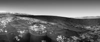
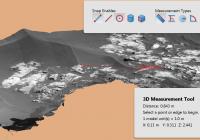
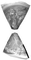
Posted by: James Sorenson Nov 30 2015, 08:18 PM
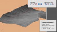
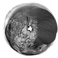
Here is a 3D DTM model that I generated using Navcam images from Sol-1174. You can rotate, and zoom up in the scene and even measure the size of objects and distances.
|
Adobe 3D PDF (6.2 Megs)
https://www.dropbox.com/s/aj5ejvfgu1cl8in/MSL_Sol1174_Navcam_DTM_front_rightside.pdf?dl=1
Posted by: neo56 Dec 1 2015, 08:08 PM
Two sections of the panorama taken with MC100 on sol 1169 at 16h10 local time. These two sections can be combined together but the MC100 picture that makes the connection was not taken with the same exposure time, hence it is difficult to debayer and calibrate colors correctly.
https://www.flickr.com/photos/105035663@N07/22797857054/sizes/o
https://www.flickr.com/photos/105035663@N07/22825531963/sizes/o
Posted by: PaulH51 Dec 2 2015, 07:17 AM
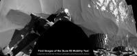
Mission Update by Ken Herkenhoff - Sol 1181: Mobility testing http://astrogeology.usgs.gov/news/astrogeology/sol-1181-mobility-testing
Posted by: PaulH51 Dec 2 2015, 12:14 PM
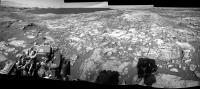
Sol 1173: L-MastCam, MS ICE, enhanced. All three RH side wheels and a mix of exposed bedrock and mini-ripples
http://www.flickr.com/photos/105796482@N04/23384232341/sizes/l
Flickr Original Size 9382 x 2075 pixels http://www.flickr.com/photos/105796482@N04/23384232341/sizes/o
Imgur http://i.imgur.com/4TAf65p.jpg
Posted by: fredk Dec 2 2015, 02:57 PM
Interesting hue variations on the dunes. Here I've increased the saturation:
|
Redder in between the crests, perhaps due to more dust collecting there?
Posted by: Phil Stooke Dec 2 2015, 07:14 PM
Reprojected Hazcam images show a little toe-dip into the dark sand on sol 1181.
Phil
|
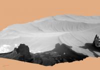
Posted by: James Sorenson Dec 2 2015, 07:27 PM
A 3D DTM of one of the wheel tracks into the dune-ripples on Sol-1181.
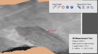
|
Adobe 3D PDF (8.7 Megs)
http://bit.ly/1N41Yp6
Posted by: PaulH51 Dec 2 2015, 11:21 PM
Meanwhile here is a few more of the available L-NavCam's roughly stitched and cropped of the RH side of the rover recording the journey on and off the leading edge of the sands
|
Imgur http://i.imgur.com/AWewm46.jpg
Posted by: Phil Stooke Dec 3 2015, 05:15 PM
http://www.midnightplanets.com/web/MSL/image/01181/CR0_502346390PRC_F0511298CCAM02181L1.html
Some great new RMI images looking over the dunes to the terrain beyond, on sol 1181.
Phil
Posted by: Arizona Dave Dec 3 2015, 08:50 PM
Awesome!!! Can you do for SOL 1176? There is an awesome disturbed area...I stitched together, but my skills really well, not the best.
Posted by: PaulH51 Dec 4 2015, 01:01 AM
Here is a mosaic using the 5 overlapping RMI's (MS ICE)
http://www.flickr.com/photos/105796482@N04/22875181364/sizes/l
Flickr Original Size 2647 x 1145 pixels http://www.flickr.com/photos/105796482@N04/22875181364/sizes/o
Imgur http://i.imgur.com/OB58hND.png
Posted by: PaulH51 Dec 4 2015, 02:28 AM
Here is the 1176 L-MastCams in a mosaic (using MS ICE), sharpened and enhanced after stitching
http://www.flickr.com/photos/105796482@N04/23397056192/sizes/l
Flickr Original Size 9229 x 1852 pixels http://www.flickr.com/photos/105796482@N04/23397056192/sizes/o
Imgur http://i.imgur.com/DR7zasp.jpg
EDIT: Mission Update by Ken Herkenhoff - Sol 1183: Completing mobility tests. http://astrogeology.usgs.gov/news/astrogeology/sol-1183-completing-mobility-tests
Later in the afternoon, the ChemCam RMI and right Mastcam will acquire a small mosaic of an outcrop up on Mount Sharp, and both Mastcams will image the ground in front of the rover. Finally, the left Mastcam will acquire a mosaic of the ground and sand to the right of the rover, and MARDI will take another twilight image.
Posted by: jccwrt Dec 4 2015, 06:20 AM
Looks like on Sols 1174, 1176, and 1178, Curiosity reimaged a small outcrop of bedrock for dust movement.
https://flic.kr/p/AS2JWF
https://flic.kr/p/AS2JWF by https://www.flickr.com/photos/132160802@N06/, on Flickr
Interestingly, it looks like there was some wind movement between Sols 1174 and 1176, as most frames show at least a couple white clasts moving between frames. I don't see similar movements between Sol 1176 and 1178.
Here's a preview gif with the frames aligned. It's pretty heavily compressed to get it down under the 1mb limit. It should still be sufficient to see some of the larger clasts moving.
|
http://i.imgur.com/wvoP6JX.gif
Due to artifacting in the public data, it's really hard to tell if smaller grains are moving, or if it's just the larger white clasts. It'll be interesting to find out over the coming weeks!
Posted by: Phil Stooke Dec 4 2015, 09:30 PM
This reprojection of the sol 1183 hazcams lets me find the new location for the map.
Phil
|
Posted by: PaulH51 Dec 5 2015, 03:30 AM
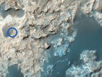
Sol 1181 RMI-ChemCam target shown in context on a debayered R-MastCam and HiRISE from Google Earth using Fernando's KML for the path.
http://www.flickr.com/photos/105796482@N04/23231143130/sizes/h
I used the measuring tool within GE to estimate the point-to point distance from the rover to the RMI target, which is fractionally under one mile (1575 meters, 0.98 miles). If I have correctly identified the RMI target, it's a ~100 meter (330 feet) wide Butte located ~122 meters (~400 feet) beyond the southern edge of the Bagnold Dunes.
Some of the detail can only be enjoyed by viewing the full size montage at 6440 x 2245 pixels http://www.flickr.com/photos/105796482@N04/23231143130/sizes/o
Imgur mirror http://i.imgur.com/pJnhtmw.jpg
Posted by: James Sorenson Dec 5 2015, 07:34 AM
A couple of Navcam and Front Hazcam DTM's at our current location from Sol-1183
Navcam DTM Arm workspace:
|
Adobe 3D PDF (8.8 Megs)
http://bit.ly/1XHDTyK
Hazcam DTM:
|
Adobe 3D PDF (6.2 Megs)
http://bit.ly/21DIFwB
3D Anaglyph and Component images
https://flic.kr/p/BRjCpDhttps://flic.kr/p/ATUy2Bhttps://flic.kr/p/ATUxp4
Posted by: PaulH51 Dec 6 2015, 10:04 AM
Sol 1182: Overlapping MAHLI's acquired at Dune #2. Assembled with MS ICE. Presented in raw, enhanced and grey-scale.
Scale bar added in lower right, thanks to Gerald. Focus stacked images have not yet been downlinked, but we can see a lot of detail in these images of the Bagnold Dune sands
http://www.flickr.com/photos/105796482@N04/22927220144/sizes/l/
Flickr Original Size 6834 x 4662 pixels http://www.flickr.com/photos/105796482@N04/22927220144/sizes/o
Imgur http://i.imgur.com/QQz2FPy.jpg
Posted by: PaulH51 Dec 7 2015, 11:30 AM
Sol 1185: Midnight Planets reports a drive ~31 meters due east, http://www.midnightplanets.com/web/MSL/sol/01185.html still missing one frame of the end-of drive images to make the 360
Appears after a brief stop to check out some older tracks the rover could be heading for Dune#1?
Here is a look ahead assembled from just 4 L-NavCams using MS ICE while we wait for the last frame
|
Posted by: jvandriel Dec 7 2015, 12:36 PM
The Navcam L view on Sol 1185.
Jan van Driel
|
|
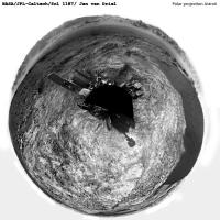
Posted by: Phil Stooke Dec 7 2015, 02:31 PM
Great! This is a circular version of it.
Phil
|
Posted by: PaulH51 Dec 7 2015, 02:41 PM
Context image for the MAHLI mosaic I posted here yesterday. I originally thought these could have been few sand covered hitch-hiking pebbles that were ejected from the inside of the wheel onto the side wall of the trench. Now I am not sure, these could be clumps of compacted sand or a compressed layer of sand. Thoughts?
https://www.flickr.com/photos/105796482@N04/23559766196/sizes/o/
Posted by: jccwrt Dec 7 2015, 05:54 PM
Upper layer of sand might have a bit of grain interlocking going on. It looks like they just rolled in from the side when the wheel trench slumped.
Murray Buttes - Sol 1181
https://flic.kr/p/BPdGen
https://flic.kr/p/BPdGen by https://www.flickr.com/photos/132160802@N06/, on Flickr
I debayered the images in gmic, and cleaned up color artifacts with the 'color replacement' tool in Photoshop. A bit of sharpening and color adjustments, and it was good to go!
Posted by: neo56 Dec 7 2015, 06:39 PM
My take on this dramatic view of the base of Mount Sharp:
https://www.flickr.com/photos/105035663@N07/23222209629/sizes/k/
And with a sky extended on Gimp:
https://www.flickr.com/photos/105035663@N07/22962315104/sizes/k/
Posted by: PaulH51 Dec 8 2015, 02:16 AM
Thanks for the feedbackCreat Processing of those Bayer encoded images guys
Here is the Mission Update by Lauren Edgar: Sols 1187-1188: Analyzing bedrock and sand http://astrogeology.usgs.gov/news/astrogeology/sols-1187-1188-analyzing-bedrock-and-sand
Todays 2-sol plan includes a targeted science block followed by a drive and post-drive imaging, and an untargeted science block on the second sol. Sol 1187 includes several ChemCam and Mastcam observations of the local bedrock at targets named Rehoboth, Hamilton_Range, and Twyfelfontein. Were also testing out some software for autonomous target selection. Then well drive towards the Namib dune and take post-drive imaging to prepare for future targeting. Overnight, Curiosity will perform a SAM Electrical Baseline Test to make sure that the power and data interfaces are all operating smoothly. On the second sol well use ChemCam, Mastcam, and Navcam to monitor the composition and opacity of the atmosphere and search for dust devils.
Posted by: neo56 Dec 8 2015, 08:08 AM
My take on RMI-Chemcam mosaic colored with a MC100 picture. Pictures taken on sol 1181 at 15h08 and 15h23 local time.
https://www.flickr.com/photos/105035663@N07/23577293796/sizes/k/
Posted by: Arizona Dave Dec 8 2015, 05:00 PM
[quote name='PaulH51' date='Dec 3 2015, 07:28 PM' post='228302']
Here is the 1176 L-MastCams in a mosaic (using MS ICE), sharpened and enhanced after stitching
Wow, really amazing...There are several very odd-interesting objects in the frame, in addition to the disrupted rock that looks like it "blew" up after being disturbed...
Something that really catches my eye is smack-dab at the lower intersection of the right 2 frames, right where the 2 frames intersect at the top of the blacked out missing area...it literally looks like translucent ice-like "wavey" thin "something"...
Also nee an interesting tube-clast sticking up in the far upper-left left-most frame.
THANK YOU!!!
Posted by: eliBonora Dec 8 2015, 05:20 PM
@PaulH51 useful context!
I'm really fascinated by the variety of grains that we have here.
Shapes, sizes and colors very different.
Some seem almost transparent, others have small holes as a melting result, each covered with stuck dust.
https://flic.kr/p/BLmdKY
Posted by: Arizona Dave Dec 8 2015, 05:21 PM
Due to artifacting in the public data, it's really hard to tell if smaller grains are moving, or if it's just the larger white clasts. It'll be interesting to find out over the coming weeks!
Very interesting, I think there are 4 definitive areas of movement...I find it very interesting larger "clasts" would be moved by wind vs smaller particles. A few of the moved particles also cast some shadows, which further prove the movement.
Maybe these are made from a mica-like mineral which is extremely light and thin...
or they are just bugs :-) either way...something moved :-)
Posted by: Arizona Dave Dec 8 2015, 05:24 PM
I'm really fascinated by the variety of grains that we have here.
Shapes, sizes and colors very different.
Some seem almost transparent, others have small holes as a melting result, each covered with stuck dust.
I looked at this image and the other 3 or 4 for 30 minutes yesterday. I see at least 3 different color of translucent grains...also of interest is the apparent distribution and common size of these grains...very uniform...and somewhat "fresh" looking.
I was thinking little raw "Diamonds" - haha, and maybe so :-)
Posted by: MrNatural Dec 8 2015, 06:34 PM
I was thinking little raw "Diamonds" - haha, and maybe so :-)
Could the translucent grains be Olivine grains?
Posted by: atomoid Dec 8 2015, 09:46 PM
Do you mean the hovering rock arm above that distinct monkey-tail crack at the top of the big nudged rock centerframe in http://www.midnightplanets.com/web/MSL/image/01176/1176ML0053300060502536E01_DXXX.html? my eyes at first misinterpreted that shadow as a sort of smudge until i looked at it again later, or maybe its the bright exposed interior of the broken rock at bottom right of that image? unfortunately i wasnt able to locate the tube clast either..
Posted by: PaulH51 Dec 9 2015, 01:00 PM
Shapes, sizes and colors very different.....
Another take on the same image posted by Eli: Focus stacked, raw colour with just a 2 cm MAHLI scale bar added (Credit Gerald)
http://www.flickr.com/photos/105796482@N04/23547408931/sizes/o
Posted by: Gerald Dec 9 2015, 06:53 PM
Chemin found forsterite (an olivine end-member) several times, so that's certainly an option.
Here the Rocknest results, http://pds-geosciences.wustl.edu/msl/msl-m-chemin-4-rdr-v1/mslcmn_1xxx/data/rdr5/.
ANDESINE,45.8,4.5
FORSTERITE,18.2,2.6
AUGITE,18.1,3.8
PIGEONITE,11.4,4.1
MAGNETITE,2.7,1
ANHYDRITE,2.1,0.7
QUARTZ,1.6,0.7
There might be some similarity between Rocknest and the dunes.
But Mars is good for surprises.
Glasses/tektites, and SiO2 might be among other options.
The recently published APXS and Chemin results (in the PDS) show bedrock rich in Si and depleted in Mg.
Here an excerpt of Chemin results for Telegraph Peak:
...
QUARTZ,1.2,0.3
CRISTOBALITE,8.7,0.7
OPAL-CT,14.5,3
...
Posted by: Actionman Dec 9 2015, 09:30 PM
fine pea gavel. Not likely to drift around in the atmosphere.
Posted by: PaulH51 Dec 10 2015, 07:33 AM
Curiosity Rover Mission Update from Ken Herkenhoff: Sols 1189-1190: Drive precluded http://astrogeology.usgs.gov/news/astrogeology/sols-1189-1190-drive-precluded
Early on Sol 1190 (when the lighting will be good), Mastcam will acquire a stereo mosaic of the "Namib" dune to the east. Later that sol, Navcam will search for clouds and ChemCam will perform a calibration activity.
Posted by: serpens Dec 10 2015, 10:07 PM
[quote name='Arizona Dave' date='Dec 8 2015, 06:21 PM' post='228436']
Very interesting, I think there are 4 definitive areas of movement...I find it very interesting larger "clasts" would be moved by wind vs smaller particles.......
The thing to note is that the particles moved in opposing directions which would make wind induced movement a little suspect. I would not discount Curiosity caused vibration as the influence in this particular case.
Posted by: Floyd Dec 11 2015, 12:28 AM
If the dunes are pea gravel, then can't we just drive across them without fear of sinking in or getting stuck? Are there some shortcuts in our future?
Posted by: serpens Dec 11 2015, 03:10 AM
The definitions for pea gravel pretty much encompass fragments in the range 2 to 9.5 mm. As shown by PaulH's image with scale bar the dune particles are much, much smaller. The toe dip into the dune edge was on a shallow ripple over rock and looking at the result I think it would be an unacceptable risk to try and traverse the dunes.
Posted by: jvandriel Dec 11 2015, 03:34 PM
The Navcam L Panorama on Sol 1187.
Jan van Driel
|
|
Posted by: Astro0 Dec 12 2015, 01:30 AM
A non-Phil polar projection of Jan's pan. 
|
Posted by: Phil Stooke Dec 12 2015, 04:10 AM
Humbug! I was too late to get mine up there first. Here's a Phil projection of Jan's panorama.
Phil
|
Posted by: PaulH51 Dec 12 2015, 06:35 AM
Curiosity Rover Mission Update from ken Herkenhoff - Sols 1191-1193: On The Road Again http://astrogeology.usgs.gov/news/astrogeology/sols-1191-1193-on-the-road-again
Posted by: PaulH51 Dec 12 2015, 11:54 AM
Sol 1189: 6 frame L-MastCam mosaic
http://www.flickr.com/photos/105796482@N04/23608726181/sizes/l/
Flickr Original Size 3920 x 2567 pixels http://www.flickr.com/photos/105796482@N04/23608726181/sizes/o/
Imgur http://i.imgur.com/QU8zQ61.jpg
Posted by: PaulH51 Dec 13 2015, 04:11 AM
Curiosity has been imaged twice by HiRISE in September and November.
|
|
|
HiRISE page with additional details as well as a series of links to higher resolution images/wallpapers, a video, an audio file as well as other formats http://www.uahirise.org/ESP_043539_1755
Posted by: PaulH51 Dec 13 2015, 06:19 AM
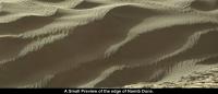
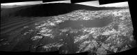
Sol 1190: A small taste of the Namib Dune from the R-Mastcam (Raw colours)
|
Posted by: PaulH51 Dec 14 2015, 11:00 AM
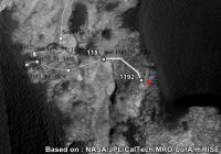
Sol 1192: Rough and Ready (MS ICE) L-NavCam end-of-drive pano. Added a very roughly estimated position of the location cropped from JPL's 1187 map. Hopefully should give you something to look at until a proper stitch is available
http://www.flickr.com/photos/105796482@N04/23741897415/sizes/l/
Flickr Original Size 8192 x 1894 pixels http://www.flickr.com/photos/105796482@N04/23741897415/sizes/o
Imgur http://i.imgur.com/p0zNuGU.jpg
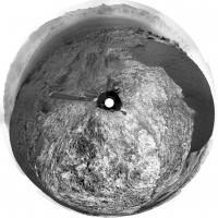
Posted by: Phil Stooke Dec 14 2015, 01:59 PM
Nice, Paul - here is a circular version of it, which allows the location to be improved slightly.
Phil
|
|
Posted by: PaulH51 Dec 14 2015, 02:27 PM
Namib dune really pops in this "Philovision", also saves the day again re the position:)
Edit : Damia's is out now, it's a gem.... http://www.db-prods.net/marsroversimages/Curiosity/2015/Sol1192_pano.jpg
Posted by: jvandriel Dec 14 2015, 02:53 PM
and here is my view of the Sol 1192 Navcam L Panorama.
Jan van Driel
|
|
Posted by: Herobrine Dec 14 2015, 08:11 PM
NAVCAM stereo travel animation for Sol 1181 is 31 frames.
Here's a small preview of the left NAVCAM's view:
And here's the full-size (512x256) stereo pair animation for http://i.imgur.com/6OkmBfk.gif and http://i.imgur.com/nJwU6YI.gif viewing. File sizes are 4.0 MiB each.
NAVCAM stereo travel animation for Sol 1183 is 25 frames.
Here's a small preview of the left NAVCAM's view:
And here's the full-size (512x256) stereo pair animation for http://i.imgur.com/uRTL51Z.gif and http://i.imgur.com/Jh6h6L0.gif viewing. File sizes are 3.1 MiB each.
NAVCAM stereo travel animation for Sol 1185 is 63 frames.
Here's a small preview of the left NAVCAM's view:
And here's the full-size (512x256) stereo pair animation for http://i.imgur.com/Q8RWdwR.gif and http://i.imgur.com/NAhctuf.gif viewing. File sizes are 8.7 MiB each.
NAVCAM stereo travel animation for Sol 1187 is 36 frames.
Here's a small preview of the left NAVCAM's view:
And here's the full-size (512x256) stereo pair animation for http://i.imgur.com/Ev5rvAw.gif and http://i.imgur.com/xNCtvba.gif viewing. File sizes are 5.5 MiB each.
NAVCAM stereo travel animation for Sol 1192 is 53 frames.
Here's a small preview of the left NAVCAM's view:
And here's the full-size (512x256) stereo pair animation for http://i.imgur.com/otXyfgt.gif and http://i.imgur.com/GYr5Jtp.gif viewing. File sizes are 7.9 MiB each.
Posted by: PaulH51 Dec 15 2015, 03:18 AM
Great animations
One of the RMI ChemCam targets from sol 1191 and its context R-MastCam (MS ICE) used to stitch the RMIs
http://www.flickr.com/photos/105796482@N04/23128621534/sizes/l
Flickr Original Size 2385 x 1960 pixels http://www.flickr.com/photos/105796482@N04/23128621534/sizes/o
Imgur http://i.imgur.com/IkYPtny.jpg
Posted by: PaulH51 Dec 15 2015, 12:52 PM
Curiosity Rover Mission Update from Lauren Edgar - Sols 1194-1195: Driving around Namib Dune http://astrogeology.usgs.gov/news/astrogeology/sols-1194-1195-driving-around-namib-dune
In todays 2-sol plan, well continue driving around the Namib Dune to get to the lee side. It was a pretty straightforward day for me as GSTL, and Ken as the MAHLI/MARDI PUL. On the first sol Curiosity will acquire ChemCam and Mastcam observations of targets named Karfenkliff and Grillental to characterize some of the local bedrock and veins. Well also take a Mastcam stereo mosaic of Namib Dune to better understand the morphology of the ripples and grain flows. The plan also includes a Mastcam image of the rover deck to monitor the movement of particles. Then well drive for ~47 m and take post-drive imaging to document the local geology and prepare for targeting in Wednesdays plan. On the second sol well perform a number of ChemCam calibration activities and take a Mastcam tau to monitor atmospheric opacity.
Posted by: PaulH51 Dec 16 2015, 01:40 AM
Curiosity Rover Report from Bethany Ehlmann:
First Visit to Martian Dunes https://youtu.be/ur_TeOs3S64
Curiosity performs the first investigation of active sand dunes on another planet. Studying the Bagnold Dunes on Mars will help scientists understand the physics of Martian dunes and how they move.
Posted by: PaulH51 Dec 16 2015, 06:40 AM
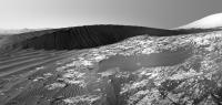
The Sol 1194 drive looks to have been completed as planned to the Lee side of Namib Dune
The NavCams are stunning with the angle of the Lee slope looking impossibly steep.
Surely just an optical illusion
|
Posted by: Sean Dec 16 2015, 03:45 PM
Nice work Paul! I have attached my version...
|
...and full size/quality here;
https://flic.kr/p/BFPLxi
I balanced exposures, repaired some gaps in the Navcams, added Mt Sharp from Sol 1169 & extended the sky.
Posted by: Arizona Dave Dec 16 2015, 06:20 PM
http://mars.jpl.nasa.gov/msl/multimedia/raw/?rawid=NRB_503502641EDR_F0512704NCAM00272M_&s=1194
Looks like they are getting some deck images to look at particles trails, plus from looks of other NavCam pics looks like we are skirting edge of dunes...amazing the dark albedo in contrast to the bright veins all over.
Its interesting how these dunes are in such close proximity to other dunes with significantly different albedo...where is the source material? Maybe we will find it on the other side? I had imagined these dunes would not be as dark and "colorful" on the ground as the appeared from HiRise and MOC, but they are, maybe even more so :-) - I just hope the wheels stay together for a long time...some of the damaged areas are looking bad :-(
Posted by: fredk Dec 16 2015, 07:10 PM
Which other dunes do you mean? Direction of solar illumination and phase angle has a big effect on the brightness of these dunes.
Posted by: neo56 Dec 16 2015, 08:41 PM
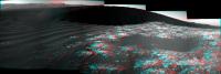
My take on this awesome view of Namib dune:
https://www.flickr.com/photos/105035663@N07/23713233831/sizes/k/
As Sean, I added a picture of Mt Sharp from sol 1169 and extended the sky.
Does someone know the height of this dune ?
Posted by: atomoid Dec 16 2015, 10:31 PM
Thanks for the nice stitches of what to me at least now has http://www.midnightplanets.com/web/MSL/image/01194/NLB_503501814EDR_F0512704NCAM00271M_.html as having one of the most picturesque postcard-worthy snapshots of the mission. here's an anaglyph from a mediocre ICE stitch and a crosseye of the best part. I still hope there are full sizes of these http://www.midnightplanets.com/web/MSL/image/01192/1192MR0054100010602613I01_DXXX.html to send back
|
|
Posted by: Sean Dec 17 2015, 03:02 AM
https://www.flickr.com/photos/105035663@N07/23713233831/sizes/k/
As Sean, I added a picture of Mt Sharp from sol 1169 and extended the sky.
Does someone know the height of this dune ?
Lovely work there Thomas... great minds think alike!
 I was too eager to complete mine before the left side of the dune appeared!
Posted by: PaulH51 Dec 17 2015, 04:30 AM
Curiosity Rover Mission Update by Lauren Edgar - Sols 1196-1197: Aeolian Paradise http://astrogeology.usgs.gov/news/astrogeology/sols-1196-1197-aeolian-paradise
|
In todays 2-sol plan, well continue driving around Namib Dune. On the first sol well use ChemCam to assess the composition and grain size of a ripple. Then well use Mastcam to image the brink of the dune and its slipface to characterize the dune morphology. Well also use Mastcam to document an outcrop with an unusual purple hue. Afterwards, Curiosity will drive even closer to the dune slipface, and well take post-drive imaging to prepare for targeting over the weekend. On the second sol, well acquire a 360-degree Mastcam mosaic for geologic context. Well also use ChemCam to monitor the composition of the atmosphere, and Mastcam to assess atmospheric opacity. Throughout the plan Curiosity will acquire a lot of REMS observations to monitor the wind as we move through this dune field. As the GSTL today, it was a real challenge to get all of these observations into the plan while staying within our data volume constraints. Its hard to curb your imaging appetite when the views are so spectacular!
Posted by: PaulH51 Dec 17 2015, 08:01 AM
Sol 1194: 3 of the 5 drive direction L-Mastcam frames that capture some of the slip slope details. Raw colours without processing post assembly in MS ICE
The planned 360 Mastcam from in front of this active dune should be a memorable image
|
Posted by: Explorer1 Dec 17 2015, 08:27 AM
Wow, what an angle! Earth dunes can never get that steep, can they? A rare reminder of the lower gravity on the red planet...
Posted by: PaulH51 Dec 17 2015, 08:58 AM
Has anyone here attempted to estimate the angle of these slip slopes? Be interesting to compare the difference between the two planets:)
Edit
With Phil and Fernando both busy, I decided to have a very rough stab at the location at the end of the 1194 drive, I've added it onto Phil's 1192 map and posted it here to keep the signal to noise ratio down on the official map thread... Comments and criticism welcome

Check out the size of the slip-slope using the scale... It looks like ~10 m? So, if we know the angle we could estimate the actual height
|
Posted by: nogal Dec 17 2015, 01:25 PM
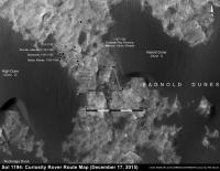
Here is a crop from MSL Traverse Map for Sol 1183. The ground seems to be sloping up, as the contour lines show a difference of at least 6m. Whether or not those are applicable to the High Dune itself I do not know. I have not seen similar data covering the Namib dune.
Fernando
|
Posted by: siravan Dec 17 2015, 03:03 PM
To the first approximation, the angle of repose is independent of the force of gravity (it cancels out). Now, this is not exactly true, as shown in this paper: http://onlinelibrary.wiley.com/doi/10.1029/2011JE003865/abstract . The actually measured the angle of repose of different materials in a "vomit comet" and saw some secondary effects.
Posted by: Phil Stooke Dec 17 2015, 04:23 PM
For a really steep slope, check this out:
http://www.ourbc.com/travel_bc/bc_cities/stewart_cassiar/photos/dease%20Lake/mountain_goat__01_640.jpg
You can't tell how steep a slope is by looking straight on to it (perpendicular to the dune foot). So a sideways view will be needed to estimate the real slope.
Phil
Posted by: jvandriel Dec 17 2015, 09:11 PM
The Navcam L view on Sol 1194.
Jan van Driel

|
Posted by: PaulH51 Dec 18 2015, 01:17 AM
JPL Press Release: Rocks Rich in Silica Present Puzzles for Mars Rover Team http://www.nasa.gov/feature/jpl/rocks-rich-in-silica-present-puzzles-for-mars-rover-team
|
Edit:
Video of the Associated Press Conference at the American Geophysical Union (AGU):
'Latest findings from NASAs Curiosity Mars rover mission One year at Mount Sharp' YouTube https://youtu.be/b1pO3qSoL2s
Duration: 18 minutes followed by 22 minutes of good questions from the press.
Members of the science team for NASAs Curiosity Mars rover describe recent findings from investigations on the lower slope of Mount Sharp (Aeolis Mons). Some rocks there are highly enriched in silica, in contrast to the rock compositions seen on the surrounding plains. Other sites on Mars, such as ground investigated by NASAs Mars Exploration Rover Spirit, are also rich in silica. Researchers are looking at similarities and differences among silica-rich sites for understanding changes in ancient wet environments.
Participants:
Ashwin Vasavada, Project Scientist for Curiosity, NASA Jet Propulsion Laboratory, Pasadena, California, U.S.A.;
Liz Rampe, Curiosity Science Team Member, Aerodyne Industries at NASA Johnson Space Center, Houston, Texas, U.S.A.;
Albert Yen, Curiosity Science Team Member, NASA Jet Propulsion Laboratory, Pasadena, California, U.S.A.;
Jens Frydenvang, Curiosity Science Team Member, Los Alamos National Laboratory, Los Alamos, New Mexico, U.S.A., and University of Copenhagen, Copenhagen, Denmark.
Posted by: Arizona Dave Dec 18 2015, 04:10 PM
Almost all other "dunes" curi has visited to date seemed to have similar albedo and color (based on images released and debayering) as the surrounding outcrops, rocks, and bedrock: One example out of thousands:
http://mars.jpl.nasa.gov/msl/multimedia/raw/?rawid=0993ML0043960760404823C00_DXXX&s=993
this is also apparent from space images...What I am surprised about, is that the current dunes really do appear as or more dark than the images from the oribiters, which sometimes (due to their angle and perspective) give a false impression of color on the ground. Its a pleasant confirmation.
Are you suggesting these dunes currently are not darker material, but are just a different angle?
Posted by: Arizona Dave Dec 18 2015, 04:17 PM
Interesting, that report's findings say that slopes should be less than on Earth...time for some good measurements.
I wonder if near Vacuum has an impact...the report didnt cover that.
Posted by: fredk Dec 18 2015, 05:22 PM
Are you suggesting these dunes currently are not darker material, but are just a different angle?
I agree the big dunes are darker than the little ripples we've driven past, typically inside the valleys. You can see this from the orbital views. I read somewhere (can't recall where now) that this was a sign of current activity on the large dunes. The small ones aren't evolving and get covered in the ubiquitous light dust.
Posted by: Gerald Dec 18 2015, 06:19 PM
In the static case you may get some more clotting in a humid environment, as favored by higher pressure, due to thin branes of water coating grains.
In a dynamical scenario higher air pressure may cause aerodynamic effects, like the https://en.wikipedia.org/wiki/Ground_effect_(aerodynamics), or higher saltation of grains.
So atmospheric pressure and composition, especially humidity, should modify slopes and dynamical behaviour of the dunes.
On Mars, less ground effect and saltation would be expected, allowing for faster settling of grains, hence steeper slopes in dynamical situations.
On the other hand, static dunes may break down earlier on Mars, due to lack of sufficient humidity to contribute to clotting of grains.
Other factors are e.g. composition, surface roughness, size, or roundness of the grains, which may well differ between Earth and Mars.
Posted by: algorithm Dec 18 2015, 08:48 PM
A low res Navcam anaglyph from Sol 1196 of the Namib dune (this really is a dune and not a ripple )
|
|
Posted by: serpens Dec 19 2015, 03:53 AM
The angle of repose for dunes on Mars should fall within the range for dry dune slip faces on Earth. The key variable would be the roundness of the basaltic particles.
Posted by: PaulH51 Dec 19 2015, 06:22 AM
Looks like we are seeing a more realistic indication of the slope (repose) angles at the edges of the algorithm's post
Sadly MS ICE won't stitch the 1196 NavCam's for me, but Damia tweeted this rather spectacular rendition earlier today
Edit
Curiosity Mission Update from Lauren Edgar - Sols 1198-1199: Dune imaging and dumping the Greenhorn sample http://astrogeology.usgs.gov/news/astrogeology/sols-1198-1199-dune-imaging-and-dumping-the-greenhorn-sample
Although today is a weekend plan, were only planning 2 sols because Sunday is a soliday (a day without planning to allow Earth and Mars schedules to sync back up). The main activity on the first sol is dumping the Greenhorn post-sieve sample and then analyzing it with both MAHLI and APXS. But we managed to squeeze in a lot of additional science observations into the plan, including some ChemCam RMIs of targets named Duineveld and Spitzkop to study the grain size and morphology of different parts of the slipface, and Mastcam imaging of several targets for change detection. Were also testing out some software for autonomous target selection, and using Mastcam and Navcam to monitor the atmosphere. Well be in the same location for a little while, so hopefully well have the chance to observe some sand movement!
Posted by: neo56 Dec 19 2015, 08:00 PM
My take on the NavCam panorama of Namib dune on sol 1196 at 15h30 local time:
https://www.flickr.com/photos/105035663@N07/23825876096/sizes/k/
I added a picture of Mt Sharp taken on sol 1169 + 3 pictures of the deck taken on sol 223, at approximately the same local time and azimuth of the rover.
Posted by: serpens Dec 19 2015, 11:34 PM
Nicely done Neo.
Posted by: jvandriel Dec 20 2015, 02:59 PM
The Navcam L view on Sol 1196.
Jan van Driel.
|
Posted by: neo56 Dec 20 2015, 03:36 PM
On sol 1197, Curiosity has made a full MC34 panorama with even MC34 pictures of the deck. This is unique as far as I know.
Only part of the panorama is available yet. I stitched these pictures to make this view of Namib dune and the northern wall of Gale crater:
https://www.flickr.com/photos/105035663@N07/23786190801/sizes/k/
Posted by: charborob Dec 20 2015, 07:42 PM
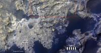
Two nice slumps on the dune's slip face. Incipient slumps are also visible here and elsewhere on the slip face.

|
Posted by: neo56 Dec 20 2015, 07:55 PM
For the first time since Curiosity landed, the MastCam team imaged http://www.midnightplanets.com/web/MSL/sol/01197.html:

|
The 360° x 360° panorama of Namib dune will be awesome !
I'm really excited but also a bit frustrated because I'm was about to release a mosaic of Curiosity's deck I was working on since one month. It includes NavCam pictures, each individually scaled and cropped to match MC34 pics. This mosaic of the deck is made of about 128 pieces and was dedicated to make a 360° x 360° panorama for sol 1144. Anyway, it can still be useful. Here is a preview of this work in progress:

|
Posted by: Arizona Dave Dec 21 2015, 06:47 PM
Latest images really interesting, especially the slumps - from this distance, the dune's material seems to be fairly consistent, except the very top where there looks to be layering.
Mission update says they are going to be there for a while and also monitor the atmosphere, so its going to be really interesting to see if we get minor morphology of the dunes in this time, and also what the air is doing around these...but im confused on how they can monitor much with the broken arm that has the wind speed sensor on it??
Nice Pano's of the Dunes and deck BTW - a lot of effort, thank you!
Posted by: Gerald Dec 22 2015, 02:02 PM
Only one of the two REMS booms is damaged. The other one works, and is able to take one set of data per second.
Posted by: mcaplinger Dec 22 2015, 04:25 PM
The REMS booms are on the remote sensing mast, not the arm.
Posted by: Herobrine Dec 22 2015, 04:43 PM
NAVCAM stereo travel animation for Sol 1194 is 65 frames.
Here's a small preview of the left NAVCAM's view:
And here is the full-size (512x256) stereo pair animation for http://i.imgur.com/yLVbbGA.gif and http://i.imgur.com/BOlbrx9.gif viewing.
File sizes are 9.3 MiB each.
NAVCAM stereo travel animation for Sol 1196 is 49 frames.
Here's a small preview of the left NAVCAM's view:
And here is the full-size (512x256) stereo pair animation for http://i.imgur.com/0rPY3kh.gif and http://i.imgur.com/X2Fs9De.gif viewing.
File sizes are 7 MiB each.
Posted by: eliBonora Dec 22 2015, 07:03 PM
360 panorama sol 1197
https://flic.kr/p/Cied3n
Posted by: vikingmars Dec 23 2015, 09:17 AM
How NICE !!!! Thanks a lot elibonora

Posted by: eliBonora Dec 23 2015, 12:27 PM
Thanks vikingmars.
I take this opportunity for a new version
https://flic.kr/p/Cs6k4c
Posted by: PaulH51 Dec 23 2015, 01:42 PM
Stunning images Eli....
Edited:
We now have the overlapping RMI images of a section of the Namib dune from sols 1200 and 1201 and 1202. Comparing the first of the frames I can see some differences between the images, but I am not sure how much of the observed differences can be attributed to lighting change as a result of the time difference that the frames were acquired across the three days...
MS ICE can not stitch the overlapping frames together, maybe someone with more skill and proper tools can look at these and see if there are any real differences?
Posted by: vikingmars Dec 23 2015, 02:14 PM
I take this opportunity for a new version
Thanks so much Elibonora : this one is very nice also and can be seen as a 'white balance' version too !
Posted by: eliBonora Dec 23 2015, 07:19 PM
Two debayerized versions of sol 1184
there is the fairy dust on the sand 
https://flic.kr/p/CsBb5k
https://flic.kr/p/Cqiq2N
Posted by: PaulH51 Dec 24 2015, 01:07 AM
Curiosity Rover Mission Update from Ryan Anderson - Sol 1201-1202: Arm Diagnostics http://astrogeology.usgs.gov/news/astrogeology/sol-1201-1202-arm-diagnostics
In addition to arm diagnostics, we still have science to do in the sol 1201 plan! Mastcam has a 10x2 mosaic to study the fine layers in a nearby outcrop, and ChemCam has a 2x2 depth profile observation of the target Matchless_2. For a depth profile, the laser fires 150 times per location rather than just 30 times, allowing us to see how the composition changes as the laser removes tiny amounts of material. Mastcam will take an image of Matchless_2 after the depth profile. On Sol 1202, we have a bunch of change detection observations of the nearby dune with Mastcam and ChemCams RMI.
Since some of the Greenhorn sample was dumped, we want to get the arm operational again as soon as possible so that the dumped sample can be analyzed before the martian wind blows it away. Were hoping that will be possible in tomorrows plan!
Posted by: James Sorenson Dec 24 2015, 08:41 AM
My version of the Sol-1197 Mastcam-34 Panorama. 
https://flic.kr/p/Cj17pE
Gigapan:
http://www.gigapan.com/gigapans/182497
Posted by: EdTruthan Dec 24 2015, 10:47 PM
Stormy Sea of Sand: The Sol 1190 MC100 42 frame dune detail set with its hypnotic array of backlit ripples and crests. The detail, delicacy, and complexity of Martian dune rippling is utterly fascinating. The MC34 counterpart of the anaglyph was resized up to MC 100 resolution to preserve full resolution detail in the right channel. Would be awesome to see a dedicated full res MC100 left channel (sigh). C' est la vie....
MC100 - 2D - Click thumb for half sized version at 11,458 x 1,519 pixels - (3.6MB)
Full Resolution version at 22,916 x 3,037 pixels (zipped) is here: http://www.edtruthan.com/mars/Sol1190-MC100-Dunes-Detail-22916x3037px.zip (11.5MB)
http://www.edtruthan.com/mars/Sol1190-MC100-Dunes-Detail-11458x1519px.jpg
MC34 / MC100 - ANAGLYPH - Click thumb for half sized version at 11,458 x 1,519 pixels - (4.5MB)
Full Resolution version at 22,916 x 3,037 pixels (zipped) is here: http://www.edtruthan.com/mars/Sol1190-MC34-MC100-Dunes-Detail-22916x3037px-Anaglyph.zip (13.2MB)
http://www.edtruthan.com/mars/Sol1190-MC34-MC100-Dunes-Detail-11458x1519px-Anaglyph.jpg
(Personal Note: Hi all. It's been 2 years this week since I posted last due to work, family, and domestic changes, but I've checked in as time has allowed. It's good to see so many of the veterans still here along with the extremely talented array of newcomers sharing so many beautiful contributions. Still a Mastcam anaglyph buff, I'll keep on the lookout for good 3D opportunities and post when I can. Couldn't resist the one above. Merry Christmas everyone!)
Edit: James and eliBonara... Awesome jobs on the 1197 MC34 pano. I putzed with it a bit and got a hard taste of how challenging the disparate exposure values and projection challenges were first hand. Beautiful work. Thanks.
Posted by: PaulH51 Dec 25 2015, 10:27 AM
Curiosity Rover Mission Update from Ryan Anderson - Sol 1202-1213: Holidays on Earth, Busy Days on Mars http://astrogeology.usgs.gov/news/astrogeology/sol-1202-1213-holidays-on-earth-busy-days-on-mars
On Sol 1202, we will first repeat the ChemCam RMI and Mastcam change detection images that weve been acquiring of the nearby dunes. Then the arm will finish its sample dumping and cleaning activities, and MAHLI will take some images of the dump pile and APXS will analyze it.
The following sol, we will repeat some of the Mastcam change detection observations. Mastcam will also re-take some of the dune images from the recent 360 degree panorama with different exposure and focus settings. ChemCam has two laser analyses of the targets Aus and Aukas and Mastcam will take some supporting images as always. After that, well take one more MAHLI image of the dump pile and then stow the arm.
Around noon on Sol 1204, ChemCam will collect some atmospheric observations (with the laser turned off), plus observations of the Greenhorn dump pile with the laser off and then with the laser on. Mastcam will also observe the dump pile, using all of its different color filters. In the afternoon, Mastcam will measure the amount of dust in the atmosphere by looking at the sun, and will take some images of the rovers deck to see if any sand from the dunes has blown up onto it. Navcam will search for dust devils and look at the horizon to measure the dust in the atmosphere. Next, the rover will adjust its position slightly so that REMS can get better wind measurements and Navcam, Mastcam, and MARDI will take the standard documentation images after the drive.
Sol 1205 will be a light day. The rover will take some measurements to update our knowledge of its tilt and orientation, and REMS will collect atmospheric measurements. Sols 1206-1213 have been pre-planned and will be pretty similar to Sol 1205, with REMS, DAN, and Mastcam environmental monitoring measurements.
While the rover is doing all of this, most of the rover team will be taking some time off to spend the holidays with friends and family, though some of us will also be working on abstracts for the Lunar and Planetary Science Conference, which are due the second week in January!
Posted by: brellis Dec 25 2015, 05:31 PM
Andrew Bodrov created an interactive panorama from images obtained on Sol 1997 here: https://www.360cities.net/image/mars-panorama-curiosity-solar-day-1197
Posted by: James Sorenson Dec 27 2015, 05:58 AM
Here is my version presented in a Polar projection.
https://flic.kr/p/CwcWuN
Focused crop of the deck:
https://flic.kr/p/BB82XB
Posted by: TheAnt Dec 28 2015, 09:42 PM
there is the fairy dust on the sand
[/url]
You mean the small bright particles? Yes I can see them clearly.
Perhaps that's 'Fools gold' (FeS2) or any of the many varieties of Mica. basically (AlSi) + some O/OH combinations.
I can also see two dotted black lines, they don't have exactly the same orientation, first I noted one and guessed it was a rolling stone that have caused it.
But found another and they look so similar that I guess that they're some image artifact, or is that from processing?
Posted by: charborob Dec 28 2015, 10:15 PM
The black dotted lines look exactly like the small laser holes made by ChemCam.
Posted by: PaulH51 Dec 28 2015, 11:29 PM
Good call, here is a RMI acquired on the same sol

|
http://mars.jpl.nasa.gov/msl-raw-images/proj/msl/redops/ods/surface/sol/01184/soas/rdr/ccam/CR0_502602945PRC_F0511430CCAM02184L1.PNG
Posted by: PaulH51 Dec 29 2015, 09:51 AM
One of the ChemCam targets from Sol 1203 (Aus or Aukas. Shown in context on the R-MastCam and a L-NavCam
http://www.flickr.com/photos/105796482@N04/23412668343/sizes/l
Flickr Original Size 3524 x 1270 pixels http://www.flickr.com/photos/105796482@N04/23412668343/sizes/o
Imgur http://i.imgur.com/oBvK6j5.jpg
Question for the members: Does anyone here know what's happening to the MastCam's on the JPL RAW image server. A couple of days ago I could not find any between sols 0 to 660, today its 0 to 800, maybe I missed a release? TIA
Posted by: Arizona Dave Dec 29 2015, 05:59 PM
Awesome set of zoomed-in images!!! NASA seems very interested in those little nodules extruding from the edges of the rock/mudstone. They appear slightly different color, and different texture as well...It would be interesting to get final size...im guestimating about 1/2 CM in diameter?
Glad you asked...I also noticed all links to the earlier SOLS are generating error, usually "Access Denied" when attempting to access them.
In a world where the US govt builds multi-YottaByte sized facilities, I cant believe a few Terabytes of data costs all that much to keep stored and humming along, so Im hoping its a transient glitch, and not the removal of images to "save resources" or money.
Hoping to get access back, there were some old pics I wanted to access this past week and couldnt.
Posted by: stevesliva Dec 29 2015, 06:24 PM
I agree that there's no good reason to think this, so don't bother saying it. It just sows discord.
The time between Christmas and New Years is usually not a high-productivity time, even for NASA...
Posted by: elakdawalla Dec 29 2015, 07:14 PM
PSA: You can generally make a set of images like these for every single ChemCam observation. The Navcam images (typically taken after the end of a drive) provide the stereo (range) data needed for targeting Mastcam and ChemCam images. They use the Navcams to plan the ChemCam shot targets, which are taken on a subsequent sol (often the very next sol after the Navcams). ChemCam observations usually have Mastcam context images taken at the same time. So pick a ChemCam image, any ChemCam image, and you can find a Mastcam of the same target on the same day and a Navcam of the same area on a previous day.
Posted by: Floyd Dec 29 2015, 07:20 PM
The web sites and their images/databases are generally not maintained by the scientists, but rather by someone tasked with public outreach. My understanding is that outreach people generally have holidays off, and so if something breaks over a long holiday, it may well not get fixed until regular business hours resume. My experience is that things that have broken or disappeared mysteriously---almost always get fixed and reappear. 
Posted by: scalbers Dec 29 2015, 07:21 PM
Those zoomed in images are nice - looks like the total zoom is around 50 times?
Posted by: elakdawalla Dec 29 2015, 08:08 PM
Navcam FOV is 45 degrees. ML is 15 degrees (when cropped square). MR is 5.1 degrees (when square). ChemCam is 1.15 degrees. So about a 40x zoom from Navcam to ChemCam. (Keep in mind the fact that while Navcam and ChemCam have 1024-pixel-square detectors, Mastcam has 1600 by 1200 so you have to be careful when comparing FOV and resolution.)
Posted by: mcaplinger Dec 29 2015, 09:53 PM
Of course the RMI is somewhat defocused at the pixel scale so its effective resolution is lower than this would suggest.
Posted by: PaulH51 Dec 30 2015, 03:41 AM
Thanks of the feedback on the Raw server, am sure it will be fixed after the holidays
19 Sol 1201 R-MastCam frames assembled with MS ICE, enhanced. I like the way the sandy ripples are aligned with the eroded channels, even when they change direction.

|
Flickr 1024 http://www.flickr.com/photos/105796482@N04/23760574980/sizes/l
Flickr Original Size 9470 x 3830 http://www.flickr.com/photos/105796482@N04/23760574980/sizes/o
Imgur http://i.imgur.com/xyp55XD.jpg
Posted by: Gerald Dec 30 2015, 01:28 PM
On Sol 1203 MAHLI's dust cover was closed. So it's hard to perceive features in http://mars.jpl.nasa.gov/msl-raw-images/msss/01203/mhli/1203MH0005530010403084C00_DXXX.jpg.
Here an enhanced version:

|
It shows the dump pile after APXS contact science.
Posted by: elakdawalla Dec 30 2015, 05:12 PM
I can't find the tweet anymore, but someone remarked on Twitter that they kept the dust cover closed for this one to make sure that there was no chance of an arm anomaly leaving the MAHLI uncovered over the holidays.
Posted by: PaulH51 Jan 5 2016, 12:14 PM
Curiosity Rover Mission Update from Lauren Edgar - Sol 1214: Catching up after the holidays http://astrogeology.usgs.gov/news/astrogeology/sol-1214-catching-up-after-the-holidays

|
In todays plan well wrap up our investigation at this particular location (on the lee side of Namib Dune) with the goal of driving to a different location tomorrow. Todays plan is focused on Mastcam change detection imaging to finish observations that began during the holiday, and a ChemCam observation on a freshly broken rock surface named Hunkab. The plan also includes some MAHLI wheel imaging. A possible drive was considered for todays plan, but deferred to allow for a longer drive tomorrow. I guess the new year is a good time to get moving again!
Posted by: fredk Jan 5 2016, 06:12 PM
After many months on walkabout in the Great Red Desert, the Mystery Man has returned to provide a sense of scale at this spectacular location:

|
The panorama is cropped (and sized 25%) from James's superb sol 1197 M34 mosaic.
Technical details: As usual the man is 2 metres tall to top of waving hand. I measured his distance to be about 14.5 m using navcam parallax, and checked with Phil's map. His height looks consistent with the total dune height of roughly 4 m stated in the releases. The dune looks taller in the middle of the image mostly because it's closer to the camera there.
Posted by: algorithm Jan 5 2016, 10:20 PM
A miraculous return from the desert.
Very welcome and still without leaving any footprints!
A man of mystery indeed.
Posted by: DeanM Jan 6 2016, 02:32 AM
I zoomed in on Mystery Man & noticed an uncanny resemblance
to "someone's" avatar, eh fredk?!
Perhaps I'm not the 1st to notice.
Dean
Edit: and MM gets around on Earth, too!
http://tinyurl.com/hg8nabg
http://tinyurl.com/h6cezoa
Posted by: MahFL Jan 6 2016, 08:56 AM
We need more MM.
Posted by: PaulH51 Jan 6 2016, 12:10 PM
Curiosity Rover Mission Update from Lauren Edgar - Sol 1215: Driving to a sampling location http://astrogeology.usgs.gov/news/astrogeology/sol-1215-driving-to-a-sampling-location

|
For more information about our investigation at the Bagnold Dunes, check out this recent http://mars.nasa.gov/msl/news/whatsnew/index.cfm?FuseAction=ShowNews&NewsID=1882 :
I should also mention that here in Flagstaff were expected to get a lot of snow so just in case this weeks blogs arent posted in a timely manner, you can keep up with Curiositys investigation by checking out the recent images http://mars.nasa.gov/msl/multimedia/raw/
Posted by: walfy Jan 6 2016, 07:44 PM
Are they planning to back track later? Or do they plan to check out a narrow straight of dune for possible crossing when the studies here are finished?
Posted by: Arizona Dave Jan 6 2016, 08:07 PM
It would be a great opportunity to study a little longer, to record actual movement...1 meter per earth year, even if 50% is in the summer, should still result in 1/6th of a meter in 3 earth months, thats 6-1/2"...so in one month we should/could observe 2 to 3 inches of movement - thats a LOT of sand to move, being that the dune is 17-19 feet tall (we are talking several TONS of material)...better yet, Curi has the capacity for HD movies...they could park and look directly at that crest for a few days, and reveal actual sand blowing over the crest, as well as sand falls...
a lot of scientific data could be garnered by video or multiple still shots of the exact same area, which could yield wind speed/direction, time of day, or if this is a gradual, or occurs in short busts, similar to dust devil events...at this stage, its all unknown, and conjecture, but we have a tool up there that is capable of studying this in great detail :-)
I did a few studies of the channels and ripples Curi studied from SOL 1201 to 1211 and there are small changes, flakes of mostly bright grains (and fairly larger than the rippled sand) from day to day...but I didnt detect too many significant changes to the sand grain or ripples, other than a few areas that seemed to drop (subside)...possibly due to curi moving and thus vibrating the rocks next to the channels.
Posted by: fredk Jan 6 2016, 09:03 PM
It looks like we're done with the leeward side of Namib - we're back to near the 1192 location. If we swing by the windward side of High Dune on our way out (I'm assuming we'll get back onto the proposed/planned route) we may be able to reimage that area 1.5 months or longer after the original images.
Posted by: PaulH51 Jan 7 2016, 04:58 AM
Roughly stitched end-of-drive L-MastCam mosaic. Roughly assembled with MS ICE using the 5 available frames, then cropped, to give us something to admire until the remaining frames come down.
http://www.flickr.com/photos/105796482@N04/24140082571/sizes/l
Flickr Original Size 3781 x 1269 pixels http://www.flickr.com/photos/105796482@N04/24140082571/sizes/o
Imgur http://i.imgur.com/XJ4U9RT.jpg
Edit
Curiosity Rover Mission Update from Lauren Edgar - Sol 1216: Looking forward to sampling and scuffing http://astrogeology.usgs.gov/news/astrogeology/sol-1216-looking-forward-to-sampling-and-scuffing

|
Posted by: dvandorn Jan 7 2016, 05:59 PM
Just a thought -- is the leeward side of an active dune the best place to sit, from a dust-pileup perspective? I can image small-grain material (dust and small fines) blowing over the top of an active dune and landing on our intrepid rover...
-the other Doug
Posted by: centsworth_II Jan 7 2016, 07:10 PM
Posted by: Herobrine Jan 7 2016, 07:18 PM
NAVCAM stereo travel animation for Sol 1215 is 56 frames.
Here's a small preview of the left NAVCAM's view:
And here is the full-size (512x256) stereo pair animation for http://i.imgur.com/onuUw7c.gif and http://i.imgur.com/lAtTldY.gif viewing.
File sizes are 7.8 MiB each.
Posted by: serpens Jan 7 2016, 10:41 PM
It seems as if the right hand side of the slip face has less collapse features than the left, although that could be a visual illusion. Looking at the time lapse orbital images of the dune movement that show the the ripples edging around the slip face rather than creating a barchanoidal horn and the ripples on the slip face it seems that the current wind is across the left slip face. The collapse features could therefore be due to reptons being pushed over the edge as well as the build up of cross ripples on the slip face rather than creep or saltons jumping over.
Posted by: PaulH51 Jan 8 2016, 01:06 AM
Curiosity Rover Mission Update from Lauren Edgar - Sol 1217: Where to sample? http://astrogeology.usgs.gov/news/astrogeology/sol-1217-where-to-sample-
The plan today involved a pre-bump Mastcam mosaic for context, and some deck imaging to monitor fines. Then Curiosity will drive toward the sampling location, and will turn the right front wheel to create a scuff in the sand. After the drive well take more imaging to prepare for targeting in the weekend plan. In the afternoon, well also use Mastcam for a change-detection observation of a nearby ripple. Ill be on duty again tomorrow, so Im excited to see how the plan works out!

|
Posted by: neo56 Jan 8 2016, 06:13 PM
Here is my take (finally!) on the spectacular panorama of Namib dune with MC34. I created a synthetic sky on Gimp to make a 360° x 360° panorama, suitable for Virtual Reality, as you can see https://www.360cities.net/image/curiosity-sol1197-mc34-fullsky
https://www.flickr.com/photos/105035663@N07/23626296494/sizes/k/
A higher resolution version of the panorama is also http://www.gigapan.com/gigapans/182989.
I filled as much as possible the gap where there is the mast. To do so, I used 8 NavCam pics taken on sols 2, 16 and 1090 that I scaled and colorized. You can see the result on this zoom on the mast's location:

|
UPDATE: here is the "little planet" version. Enjoy !
https://www.flickr.com/photos/105035663@N07/24273332235/sizes/k/
Posted by: jvandriel Jan 8 2016, 08:04 PM
The complete Navcam L panoramic view on Sol 1215.
Jan van Driel
|
|
Posted by: Phil Stooke Jan 8 2016, 09:11 PM
Thanks, Jan - here is a circular view of your panorama. Comparing the edge of the dune here with the same area in the HiRISE image used for my current route map, there is no obvious change at all in the position of the dune base. However, the barchan shape of the dune indicates it should be moving from north to south here, along this face rather than perpendicular to it, so no significant change would be expected here.
Phil

|
Posted by: PaulH51 Jan 9 2016, 11:43 AM
Curiosity Rover Mission Update from Lauren Edgar - Sols 1218-1220: Change in plans http://astrogeology.usgs.gov/news/astrogeology/sols-1218-1220-change-in-plans
Posted by: James Sorenson Jan 9 2016, 11:12 PM
A 360 degree Navcan DTM from Sol-1216 (which because of the anomaly, is still our current position). I have crossed checked some random measurements made using Adobe 3D's measurement tool with Algorimancer PG and both are on par with range and size of what was measured. It maybe resource intensive depending on computers, I had to crop the DTM down some because of this.
Adobe 3D PDF (6.83 Megs)
http://bit.ly/1mMnR5z

|

|
Posted by: jvandriel Jan 10 2016, 02:30 PM
The Navcam L panoramic view on Sol 1216.
Jan van Driel
|
|
Posted by: eliBonora Jan 10 2016, 07:22 PM
Some ripples mosaic:
Mastcam R sol 1190 and sol 1192 (debayerized)
https://flic.kr/p/CPRpMU
sol 1992 debayerized detail
https://flic.kr/p/CxhRcS
and sol 1190 1992 20860x2293 pixel anaglyph
https://flic.kr/p/C49B3B
Posted by: Phil Stooke Jan 10 2016, 10:46 PM
Beautiful images, thanks!
Here is Jan's Navcam panorama for sol 1216 (where we remain as I post this) in circular form. The scuffing and sampling area is just above (north of) the centre.
Phil

|
Posted by: PaulH51 Jan 12 2016, 12:31 AM
Curiosity Rover Mission Update from Ken Herkenhoff - Sols 1221-1222: Back on track http://astrogeology.usgs.gov/news/astrogeology/sols-1221-1222-back-on-track
Posted by: fredk Jan 12 2016, 03:42 PM
Some subtle clouds drifting by on 1216:

|
I subtracted the average of the frames from each frame, then stretched and smoothed. There are probably some artifacts of the differencing since the average will contain features and not be perfectly smooth. But for the most part the motion is real.
Posted by: Phil Stooke Jan 13 2016, 04:41 AM
Nice cloud movie!
We just had a short drive and a turn in place to scuff the dune. These reprojected hazcams help me find our new location.
Phil

|
Posted by: PaulH51 Jan 13 2016, 06:07 AM
Nicely deduced Phil
Here is a small R-NavCam mosaic of the 'Wheel Scuff' (Assembled using MS ICE) No other full frame images downlinked yet...
http://www.flickr.com/photos/105796482@N04/23981028369/sizes/l
Flickr Original Size 1826 x 1288 pixels http://www.flickr.com/photos/105796482@N04/23981028369/sizes/o
Imgur http://i.imgur.com/D3Bgk13.jpg
Posted by: algorithm Jan 13 2016, 08:43 PM
Playing on the beach

|
Just need some water to come and fill in the moat
Posted by: PaulH51 Jan 14 2016, 01:28 AM
Curiosity Rover Mission Update from Ken Herkenhoff - Sols 1223-1224: Scooping sand for SAM http://astrogeology.usgs.gov/news/astrogeology/sols-1223-1224-scooping-sand-for-sam
Posted by: PaulH51 Jan 14 2016, 07:10 AM
Sol 1221: 3x3 R-MastCam mosaic assembled in MS ICE. Includes what looks like some LIBS activity atop a ripple in the undisturbed dune.
http://www.flickr.com/photos/105796482@N04/24260473822/sizes/l
Flickr Original Size 3676 x 3438 pixels http://www.flickr.com/photos/105796482@N04/24260473822/sizes/o
Imgur http://i.imgur.com/eigOWRJ.jpg
Posted by: PaulH51 Jan 14 2016, 12:25 PM
Sol 1222 RMI Mosaic of the the wall of a ~4 km-diameter crater, situated about 30 km to the West of the rover (mentioned in the recent USGS Mission Update. The final mosaic has been sharpened the Raw RMI's were cropped before stitching in MS ICE as I get better results that way.
Looking at the raw image server we may get one further RMI (ENHANCED Data Product). If so I will reissue a higher resolution version if we get that 5th RMI, and hopefully an associated MastCam context image

|
Posted by: fredk Jan 14 2016, 03:48 PM
Thanks a lot, Paul. That's by far our best view of that big crater. I think our previous best was the sol 529 MR sequence - see the mosaics starting around http://www.unmannedspaceflight.com/index.php?s=&showtopic=7747&view=findpost&p=207059
Posted by: Phil Stooke Jan 14 2016, 05:19 PM
The crater is identified as 'crater A' here:
http://www.unmannedspaceflight.com/index.php?showtopic=8114&st=60
Phil
Posted by: Phil Stooke Jan 14 2016, 05:26 PM
http://www.midnightplanets.com/web/MSL/image/01221/1221ML0056000160503637E01_DXXX.html
It's amazing how landforms can repeat themselves at very different scales, and even different materials. This scuff could be the wall of Valles Marineris, with stratified cliffs at the top, spurs of rock extending down the slope, and the vast talus apron below it. It's like looking at tiny braided streams and deltas where water seeps down a sandy beach as the tide goes out - geology in miniature. Always one of my favorite things to look at when not chained to my desk.
Phil
Posted by: jvandriel Jan 14 2016, 08:24 PM
The Navcam L view on Sol 1221.
Jan van Driel

|
Posted by: atomoid Jan 14 2016, 09:29 PM
http://www.midnightplanets.com/web/MSL/image/01221/1221MR0055980040603226E01_DXXX.html?
Posted by: PaulH51 Jan 14 2016, 10:10 PM
http://www.midnightplanets.com/web/MSL/image/01221/1221MR0055980040603226E01_DXXX.html?
According to The USGS mission plan, some LIBS activity was planned for sol 1221, but Ken only detailed one target and that was done before the drive. Now we have a lot more post drive images, but no RMI's of targets on the dune. So these pits are probably caused by something other than LIBS. Probably too far to be debris from the rover deck. But one of many possibilities is something liberated from the wheel during wheel scuffing?
Posted by: fredk Jan 15 2016, 04:31 AM
Squinting at a 1221 FLB, the pits appear to have been there, which was before the nearby scuff:

|
Posted by: PaulH51 Jan 15 2016, 06:01 AM
Hmmm Interesting...
JPL have just released the http://mars.jpl.nasa.gov/msl/multimedia/images/?ImageID=7639 and http://mars.jpl.nasa.gov/msl/multimedia/images/?ImageID=7640 maps for sol 1221, these show a point to point distance of the drive of about 16.51 feet (5.03 meters), so likely within range of the laser before the last drive? However, I can't find any context RMI's from the sols leading up to the drive, so we should be able to rule out LIBS.
We now have a total of 34 http://mars.jpl.nasa.gov/msl/multimedia/raw/?s=1221&camera=MAST_ that cover an extensive area of the dune. I tried assembling these using MS ICE, but the resulting 3x11 mosaic suffered badly from stitching errors. However, I did notice several other 'pits' in the undisturbed surface. Therefore, I think we are likely observing a natural 'active dune process'.
Posted by: PaulH51 Jan 15 2016, 07:57 AM
Sol 1221 L-MastCam mosaic, selected frames only. Some interesting colour variations, some are highly likely to be compression issues, but others appear to be real variations. Raw colours, just sharpened a little Hopefully we will see other versions posted here
http://www.flickr.com/photos/105796482@N04/23763322253/sizes/l
Flickr Original Size 6739 x 3145 pixels http://www.flickr.com/photos/105796482@N04/23763322253/sizes/o
Imgur http://i.imgur.com/cN7e0lB.jpg
Posted by: Phil Stooke Jan 15 2016, 05:17 PM
This is a circular reprojection of Jan's pan for sol 1221, posted above.
Phil

|
Posted by: James Sorenson Jan 15 2016, 08:38 PM
A three dimensional terrain model produced from Navcam's on Sol-1121 of the arm workspace in front of the rover and off to the right side. I will produce a model when images of the scooping is down as well.
Adobe 3D PDF (22.2 Megs) Maybe computer resource intensive.
http://bit.ly/1QaqQ3H

|
Posted by: fredk Jan 15 2016, 09:49 PM
The pits were clearly not there before the 1221 drive:

|
So either LIBS without RMI or something from the relatively nearby 1221 drive (but pre-scuff).
Posted by: PaulH51 Jan 16 2016, 08:38 AM
Agreed... Still no context images from ChemCam
We do have some nice sol 1223 MAHLI close-ups of the dune, but no focus stacks yet. Here is one in raw and processed formats (I just sharpened and stretched the colour saturation levels to enhance the existing colours) Scale bar added thanks to Gerald's MAHLI RULER.
http://www.flickr.com/photos/105796482@N04/24113976720/sizes/l
Flickr Original Size 3229 x 1400 pixels http://www.flickr.com/photos/105796482@N04/24113976720/sizes/o
Imgur http://i.imgur.com/gc2B8pK.jpg
Posted by: PaulH51 Jan 16 2016, 02:15 PM
Weekend mission update by Lauren Edgar - Sols 1225-1227: Analyzing dump piles:
Link: http://astrogeology.usgs.gov/news/astrogeology/sols-1225-1227-analyzing-dump-piles
As seen in the images above, the arm activities on Sols 1223-1224 went well, and were ready for even more contact science in the 3-sol weekend plan. To kick things off, ChemCam will analyze the composition of the wall of the scuff and will also document a sharp-crested ripple with the RMI. Then Mastcam will document the ChemCam target and look for sandmovement. Overnight, APXS will be used to measure the composition of the background undisturbed sand. On the second sol, a fine-grained portion of sand (<150 microns) will be delivered to CheMin for analysis. Then well dump both the fine (<150 microns) and coarse-grained (> 150 microns) portions, and analyze the fine-grained dump pile with MAHLI and APXS. The third sol includes a Mastcam change-detection activity, followed by Navcam to monitor the deck to search for the movement of fines. Overnight, CheMin will analyze the sample that was delivered the previous sol. Phew! Sounds like a busy weekend for Curiosity!
Posted by: James Sorenson Jan 16 2016, 10:39 PM
The scoop trench, and some interesting wind related changes in the wheel scuff over the coarse of an hour.

|
EDIT: Whoops, the animation should show Sol-1224.
EDIT: After going back through previous sol's, I didn't find any changes. It seems to be focused between that hour while scooping and sieving. The movement could also be from the vibrations induced into the ground through the wheels. I'm favoring that right now, but I'm gonna keep an eye on it over the next couple of sols.
MOD EDIT: Deleted double post but that broke attachment, re-uploaded it to this one to fix.
Posted by: PaulH51 Jan 17 2016, 01:55 AM
Great spot James...
We can also observe what appears to be the creation of the 'unwanted sample dump pile' to the LH side of of your animation. The dumping activity was mentioned in the http://astrogeology.usgs.gov/news/astrogeology/sols-1225-1227-analyzing-dump-piles
I was actually hoping they would use the sample tray for some of these unwanted sample, but I guess it's just too windy in this location
Posted by: PaulH51 Jan 17 2016, 10:56 AM
Some nice L & R MastCam's from sol 1224 showing the Namib dune sample in the scoop. Available now at http://www.midnightplanets.com/web/MSL/sol/01224.html

|

|
Posted by: elakdawalla Jan 18 2016, 04:32 PM
Apparently because the amount of vibration that happens on the arm to move samples around, the O-tray just hasn't worked out as an investigative tool, unfortunately. Vibration is transmitted to body and sample just doesn't stay put.
Posted by: PaulH51 Jan 18 2016, 10:21 PM
Thanks Emily... Pity, but all part of the learning curve... On the bright side... If they decide not to modify the O-tray design, and simply omit it from the next rover, they should be able to cram in another instrument or two, maybe even a microphone?
Mission update from Ryan Anderson - Sol 1228-1229: Selfie and Scooping http://astrogeology.usgs.gov/news/astrogeology/sol-1228-1229-selfie-and-scooping
On Sol 1229, Mastcam will repeat that change detection observation two more times. Mastcam also has observations of the dump piles from the scoop target Gobabeb, plus a Mastcam and Navcam photometry experiment. ChemCam will take passive spectra of the Gobabeb dump piles, followed by active analysis of dump pile A. That will be followed by atmospheric observations by Mastcam and Navcam.
In the afternoon on Sol 1229, ChemCam will analyze dump pile B, and Mastcam will take another change detection image of Hebron. The Mastcam and Navcam photometry experiment will also collect a few more images on sol 1229.

|
Posted by: PaulH51 Jan 19 2016, 01:18 AM
Sol 1226: CHIMRA's internal chambers looking just like new (after processing the dune sands)

|

|

|
A stark contrast when compared with the dusty deck around the CheMin Inlet Port / wind shield...

|
Posted by: PaulH51 Jan 19 2016, 09:50 AM
Animated GIF: Sol 1226 - Nice colour and grain size separation in the dump piles A & B Registration is a little off...
Reduced the size to post here, click the preview to run the animation

|
Sol 1226 MatCams http://mars.jpl.nasa.gov/msl/multimedia/raw/?s=1226&camera=MAST_
Posted by: PaulH51 Jan 21 2016, 03:36 AM
Sol 1228 L-Mastcam: Unusual placement of the arm/turret when checking out the scoop?
Appears to be well behind the mast If they have done this before, I must have missed it

|
http://mars.jpl.nasa.gov/msl-raw-images/msss/01228/mcam/1228ML0036650010503708E01_DXXX.jpg
EDIT: Today on the tweet-sphere I learned that this is "A textbook 150micron-1mm aliquot". I also learned a new word
Posted by: PaulH51 Jan 21 2016, 11:18 AM
Sol 1229 Simple 4-frame RMI animation of LIBS activity across one of the sample dump piles at the Namib dune.
Raw images used, but size reduced to 700x700 to meet upload requirements.

|
click preview to run the animations
Posted by: elakdawalla Jan 21 2016, 04:16 PM
Appears to be well behind the mast
If they have done this before, I must have missed it EDIT: Today on the tweet-sphere I learned that this is "A textbook 150micron-1mm aliquot". I also learned a new word
They haven't done this before -- I explained it in http://www.planetary.org/blogs/emily-lakdawalla/2016/01071754-curiosity-update-sols-1166-1217.html:
The "aliquot" is a single portion of 150-1 millimeter sand, and the scoop is where it is because they are going to dump it directly from the scoop into SAM. Because they are now typically delivering 2-3 portions of sample to SAM, they'll probably go through the process of scooping, sieving, and dumping at least one more time before running the SAM analysis.
Posted by: PaulH51 Jan 22 2016, 02:07 AM
Thanks Emily
JPL issued this report after your reply http://www.jpl.nasa.gov/news/news.php?feature=4826
Posted by: PaulH51 Jan 22 2016, 11:42 AM
Curiosity Mission Update: Sol 1230-1231: 'Getting the scoop at Namib Dune from Ryan Anderson' http://astrogeology.usgs.gov/news/astrogeology/sol-1230-1231-getting-the-scoop-at-namib-dune
On Sol 1231, we will start off with some Navcam and Hazcam images to document where APXS was making its measurements, plus Mastcam observations of the SAM inlet again. This will be followed by some arm activities to clean out the components of the sample handling system. Then we'll dive back in and collect another scoop of material from the dune, sieve it, and deliver it to SAM too. Finally, APXS will be placed on another of our dump piles for an overnight measurement. And of course REMS and DAN will be collecting data each sol of the plan as usual.

|
Posted by: PaulH51 Jan 23 2016, 04:58 AM
Curiosity Mission Update: Sol 1232-1235: Working through the To-Do list (by Ryan Anderson) http://astrogeology.usgs.gov/news/astrogeology/sol-1232-1235-working-through-the-to-do-list
On sol 1234, we have a long, busy science block full of Mastcam and ChemCam. It starts off with Mastcam multispectral observations of the Sanitatis vein, and of dump piles C,D,E, and F. This is followed by some Mastcam atmospheric observations of the sun and the crater rim to help determine the amount of dust in the atmosphere. ChemCam will then analyze dump piles C and D, first with the laser off to get the reflectance spectra, and then with the laser on to get chemical composition. ChemCam will also use the laser to analyze the soil target Dwyka and then will finish up with a long distance RMI mosaic of Mt. Sharp. Then we will take Mastcam images of each of the ChemCam targets. We will finish up the science block with some photometry images from Mastcam and Navcam to help understand how light scatters off the Martian surface, and then some Navcam atmospheric monitoring movies. Finally, APXS will analyze dump pile B overnight.
The weekend plan also includes an early morning science block on the morning of sol 1235, which will contain more Navcam movies, Mastcam observations of atmospheric dust, and a repeat of the photometry experiment at a different time of day to capture a different lighting angle.
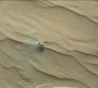
|
Posted by: PaulH51 Jan 23 2016, 10:54 AM
Three Bites Of The Cherry (Animation)
Simple animation using 4 HazCam frames showing the scoop sites and the creation of the small dump piles over a series of sols. Click the preview to run the animation in a new tab.
https://www.flickr.com/photos/105796482@N04/23927271034/sizes/o/
Posted by: PaulH51 Jan 25 2016, 01:25 AM
Sol 1231 Merge Focus MAHLI, Group one white LEDs only. Scale Bar derived from focus count of one of the base images (15008) Credit to Gerald for the MAHLI Ruler
Beautiful Grains
https://www.flickr.com/photos/105796482@N04/24483811912/sizes/o/
Imgur mirror http://i.imgur.com/drOIOzL.jpg Raw image http://mars.jpl.nasa.gov/msl-raw-images/msss/01231/mhli/1231MH0001630000403553R00_DXXX.jpg
Posted by: PaulH51 Jan 25 2016, 06:52 AM
Advance cropped version of the sol 1228 MAHLI Selfie at Namib, created in MS ICE. This should fill the gap until the regular image Guru's issue their versions
http://www.flickr.com/photos/105796482@N04/24571234586/sizes/l/
Flickr 10400 x 4732 http://www.flickr.com/photos/105796482@N04/24571234586/sizes/o/
Posted by: DeanM Jan 25 2016, 10:20 AM
Paul: Great image!
From which, I'm curious: much of the deck shows expected accumulated dust, but not so the thermal radiative 'fins' of the RTG.
Is this because the RTG heats a thin layer of (thin) atmosphere around the cooling vanes which then avoids deposition of dust?
Dean
Posted by: PaulH51 Jan 25 2016, 11:04 AM
Is this because the RTG heats a thin layer of (thin) atmosphere around the cooling vanes which then avoids deposition of dust?
Dean, that's a good question. I don't know about the effect of heating would have, but it's always possible, hopefully someone else here may be able to throw some additional light on your question. However, I've always assumed the lack of dust on the radiator vanes was associated with the inclined angle of the RTG and its vanes, plus the additional effect of driving vibrations etc that prevents build up of dust accumulations on the vanes where the vibration would be amplified a little because of their thin walls, but that is pure speculation on my part. Looking forward to seeing some other theories
Posted by: James Sorenson Jan 25 2016, 08:47 PM
Great work Paul!
My version of the new Selfie.
https://flic.kr/p/Cwvdmb
Also on
RoundMe VR Panorama:
https://round.me/tour/26137/view/62854/
Gigapan:
http://www.gigapan.com/gigapans/183516
Posted by: elakdawalla Jan 25 2016, 09:58 PM
Superb. The RoundMe panoramas work better when you extend them to cover the whole space. I added some vertical space to make the height of the panorama equal to half the width of the panorama, and the result is terrific: https://round.me/tour/26229/view/63043/ -- but it would probably look better if you uploaded your own version!
Posted by: James Sorenson Jan 26 2016, 12:50 AM
Thank you Emily for the helpful tip. I just joined RoundMe yesterday, so I'll see what I can do on this one and re-upload.
Edit: Oh nevermind! Haha Thanks for doing that.
Posted by: James Sorenson Jan 26 2016, 02:24 AM
Thank you Emily for the helpful tip. I just joined RoundMe yesterday, so I'll see what I can do on this one and re-upload.
Edit: Oh nevermind! Haha Thanks for doing that.
Edit: I added the extra space in the sky and re-uploaded onto my account. In the future, I'll just add more sky instead of black. Looks much better!
https://round.me/tour/26137/view/63127/
Posted by: Gerald Jan 26 2016, 12:18 PM
The first time I see possible fluorescence in MAHLI images, as gif comparing white led with cleaned uv crops:

|
Might still be some specular reflection, but when comparing to nearby bright grains I'm preferring the fluorescence option.
Posted by: PaulH51 Jan 27 2016, 10:34 AM
Curiosity Mission Update: Sols 1235-1236 - CHIMRA Anomaly from Ken Herkenhoff http://astrogeology.usgs.gov/news/astrogeology/sols-1235-1236-chimra-anomaly
The Sol 1235 plan includes ChemCam and Mastcam change-detection images of Hebron and new observations of the scuff floor target Husab. In addition, ChemCam will analyze bedrock target "Etjo" and Mastcam will image CHIMRA to confirm its configuration. Overnight, SAM will
analyze the 0.15-1.0 mm size fraction of the dune sand. Before dawn on Sol 1236, ChemCam will search for evidence of water frost on both fine sand and the Etjo bedrock target. After sunrise, the ChemCam RMI and Right Mastcam will take pictures of the same frost targets, then Mastcam and Navcam will acquire an early-morning set of photometry images. Later that sol, ChemCam will observe the sky and Mastcam will repeat the Hebron observation to look for changes. Finally, Mastcam and Navcam will repeat the photometry observation later in the morning of Sol 1237.

|
Posted by: neo56 Jan 27 2016, 08:24 PM
Really nice work James !
Here is my take on this self-portrait:
https://www.flickr.com/photos/105035663@N07/24561838181/sizes/k/
https://www.flickr.com/photos/105035663@N07/24564056601/sizes/k/
And my https://round.me/tour/26478/view/63655/, for which I was inspired by your conversation Emily and James
Posted by: PaulH51 Jan 28 2016, 02:53 AM
Curiosity Mission Update: Sols 1237-1238 - 'CHIMRA Diagnostics from Ken Herkenhoff' http://astrogeology.usgs.gov/news/astrogeology/sols-1237-1238-chimra-diagnostics
In addition to the CHIMRA diagnostic tests on Sol 1237, ChemCam and Mastcam will image the alluvial fan northeast of the rover, at the http://mars.jpl.nasa.gov/msl-raw-images/proj/msl/redops/ods/surface/sol/01221/opgs/edr/ncam/NLB_505898403EDR_F0521162NCAM12753M_.JPG. Mastcam and Navcam will also take stereo images of the edge of the area disturbed by the wheel scuff, named "Mniszechis Vlei." I don't know how to pronounce that name, and didn't even try!
The command to allow SAM to analyze the sample of dune sand was not received, so we'll try again overnight between Sols 1237 and 1238. Then during the day on Sol 1238 ChemCam will observe the sky and continue checking out new software that will allow autonomous ChemCam targeting. Mastcam change detection observations of the sand dune are also sprinkled throughout the plan. Finally, just after sunset the RMI will take images of the sky for instrument calibration. We have been trying to plan this observation for weeks, and were glad to be able to include it in today's plan.

|
Posted by: eliBonora Jan 28 2016, 04:37 AM
All nice works!
This is our selfie version:
https://flic.kr/p/CAE9A3
Posted by: PaulH51 Jan 30 2016, 07:10 AM
Curiosity Mission Update from Ryan Anderson: Sol 1239-1240: 'Analyzing the Sands of Mars' http://astrogeology.usgs.gov/news/astrogeology/sol-1239-1240-analyzing-the-sands-of-mars
On Sol 1239 we planned a bunch of observations of a target called Gosser Schroffenstein in the area called Mniszechis Vlei (I am really enjoying the names list lately) where the rovers wheel scuff in the sand exposed a tiny scarp or cliff in the sand. This little scarp gives us a good view of the fine-scaled layering in the top few centimeters of the dune. ChemCam will take an RMI mosaic of Gosser Schroffenstein, followed by an active LIBS analysis targeting the face of the scarp. After that, the RMI mosaic will be repeated to see if the laser pulses caused any changes in the delicate sand scarp. Once ChemCam is done, Mastcam will take a 5 image stereo mosaic of the whole Mniszechis Vlei area. Mastcam also has another change detection observation of the target Hebron and Navcam has an atmospheric observation. Once the science is done on Sol 1239, we will do some more diagnostics on the CHIMRA. Later in the day on Sol 1239, CheMin will analyze some of the sand that was collected previously.
On Sol 1240 ChemCam has a few passive (no laser) observations of the Mastcam and ChemCam calibration targets. These are followed by a couple of long-distance RMI mosaics of Mt. Sharp. These are observations that I have been advocating for recently, so it was nice to be able to fit them in the plan today while I was on duty as the ChemCam science PUL. Mastcam will take color images to help document the long distance RMI mosaics, and will repeat the change detection observations of Hebron a couple more times.

|

|
Posted by: neo56 Jan 30 2016, 09:11 PM
I made a photomontage of the six self-portraits taken so far by Curiosity.
EDIT: The low-angle Buckskin self-portrait will be included in a future photomontage.
https://www.flickr.com/photos/105035663@N07/24087940183/sizes/k/
Posted by: PaulH51 Jan 31 2016, 05:08 AM
Sol 1237 R-MastCam: 2-frame 'blink animation'. Likely to be one of the planned CHIMRA diagnostic tests: Shows a small amount of movement on an inspection cover for one of CHIMRA's internal chambers. The time-stamps differ by less than a minute. Size reduced to 800x635 to match page upload limits. Select the preview to run the animation. Maybe the cover did not close properly which caused the anomaly? Hopefully it is not associated with the welds of the 150 micron screen (which is located inside this chamber)

|
Posted by: Gerald Jan 31 2016, 11:59 AM
I thought, they are using the 1mm sieve for the first time, together with a new processing sequence.
So this could be a checkout of a new technique. That's always associated with some risk, that it doesn't work perfectly with the first attempt.
Posted by: neo56 Jan 31 2016, 03:11 PM
I merged the 6 selfies into an animation showing dust depositing on Curiosity:

|
Higher resolution version https://www.flickr.com/photos/105035663@N07/24729503745/sizes/o/.
Posted by: anticitizen2 Feb 1 2016, 12:39 AM
Animations of sand movement during lasering:
From Navcam

|
From http://i.imgur.com/7LadTqy.gif
Posted by: Gerald Feb 1 2016, 10:54 AM
Interesting, that there is a crust on an active dune.

|
Posted by: PaulH51 Feb 1 2016, 12:13 PM
Interesting indeed
One of the long-distance RMI mosaics of Mt. Sharp planned for Sol 1240 (3 frames) Stitched in MS ICE after partial cropping, otherwise raw

|
Posted by: atomoid Feb 2 2016, 12:21 AM
'active dune' crusts, another conundrum.. or an 'active crust' as slips downslope such as at top here http://www.midnightplanets.com/web/MSL/image/01236/NRB_507205946EDR_F0521162NCAM00323M_.html
looking back, noticed this nice reflection from http://www.midnightplanets.com/web/MSL/image/01235/NRB_507110361EDR_F0521162NCAM00322M_.html crosseye detail. i don't recall seeing such reflections before, perhaps just needed a good 'screen' to project onto.

|
Posted by: PaulH51 Feb 2 2016, 02:19 AM
Curiosity Mission Update from Lauren Edgar: 'Sol 1241: Wrapping up at Namib Dune' http://astrogeology.usgs.gov/news/astrogeology/sol-1241-wrapping-up-at-namib-dune
The science activities in todays plan include some additional MAHLI images to supplement the previously acquired selfie, and some long-distance ChemCam RMI mosaics to study layering on Mt. Sharp and the northern crater rim. Well also acquire a Mastcam image to document the target Erongo, and use Navcam to search for dust devils and monitor the atmosphere. Then well use MAHLI to document several of the scoop and dump locations. Theres also an early science block on the morning of Sol 1242, during which Mastcam and Navcam will image the ripple target Epupa under favorable morning illumination conditions. Ill be on duty later this week so Im catching up on our remaining science requirements at this location.

|
Edit: and another long distance RMI, this time sol 1234, assembled in MS ICE with additional processing

|
I was wondering if there is any overlap in the long distance RMI's of the base of Mt Sharp. I understand that the rover has moved a many times, but at this distance maybe they will still assemble?
Posted by: PaulH51 Feb 4 2016, 01:04 PM
And the CHIMRA Check-outs continue.... Sol 1242: Multiple frames R-MC, animations reduced to 400x300.

|

|
Posted by: Gerald Feb 4 2016, 04:44 PM
A partial NRB pano after tosol's (sol 1243) short drive, showing tracks of recent rover activity:

|
Posted by: PaulH51 Feb 5 2016, 03:16 AM
Nice work Gerald... Here is the next plan...
Curiosity Mission Update from Lauren Edgar - 'Sol 1244: Bump, Set Scuff!' http://astrogeology.usgs.gov/news/astrogeology/sol-1244-bump-set-scuff-
I was the GSTL today, and we had a busy morning deciding where to drive to and how to image the scuff that well create. We decided to bump just a few meters away to a target that will allow us to characterize typical Murray formation bedrock (the intended target is in the lower half of the above Navcam image). Before the drive, we planned a ChemCam passive observation of a distant crater to characterize the material that makes up the Gale crater walls. We also planned a Mastcam image of a freshly broken rock named Askevold, and Mastcam deck monitoring to search for the movement of fines. Then well drive forward slightly, turn the wheels to undermine a ripple, image it with Mastcam, and then drive towards the contact science target. After the drive well acquire imaging to prepare for contact science and targeting in the weekend plan, and well also do some ChemCam calibration activities. Looking forward to being back on bedrock!

|
Posted by: PaulH51 Feb 5 2016, 11:55 AM
The Bump on Sol 1244 was completed as planned, including the new wheel scuff that can be seen in this post drive rear left HazCam

|
The end of drive NavCam's are so far incomplete, but the drive is being reported as 1.8 meters WSW by Midnight Planets http://www.midnightplanets.com/web/MSL/sol/01244.html
Edit: MS ICE - 5 Frames, L-NavCam
http://www.flickr.com/photos/105796482@N04/24738373381/sizes/l
Flickr Original Size 3853 x 1361 pixels http://www.flickr.com/photos/105796482@N04/24738373381/sizes/o
Posted by: PaulH51 Feb 6 2016, 07:34 AM
Curiosity Mission Update from Lauren Edgar: Sols 1245-1247: Analyzing Murray formation bedrock' http://astrogeology.usgs.gov/news/astrogeology/sols-1245-1247-analyzing-murray-formation-bedrock
The 3-sol weekend plan starts by using the DRT to clear off the dust on the target Kudis. Then well acquire MAHLI images of this typical Murray formation bedrock. Nearby, theres an interesting patch of nodules, so the science team decided to go for a second MAHLI target named Tinkas. In addition to all of the contact science on Kudis and Tinkas, MAHLI will also be used for wheel imaging and to check out the REMS UV sensor. Overnight, well acquire APXS data on both targets, to compare the typical bedrock composition to the nodule-rich composition. On the second sol, Curiosity will wake up early for some atmospheric monitoring observations. Around midday, well acquire Mastcam multispectral imaging of Kudis, followed by a ChemCam passive observation of the sky. ChemCam will also be used to assess the composition of typical bedrock and the nodule-rich rock, and Mastcam will document the local geology. On the third sol, Curiosity will drive towards the Naukluft Plateau, and acquire post-drive imaging to prepare for next week. Sounds like a busy weekend!

|
Posted by: PaulH51 Feb 6 2016, 01:29 PM
12 frame R-MastCam mosaic (sol 1244) roughly stitched in MS ICE
http://www.flickr.com/photos/105796482@N04/24850936645/sizes/l
Flickr Original Size 4600 x 3343 pixels http://www.flickr.com/photos/105796482@N04/24850936645/sizes/o
Posted by: jvandriel Feb 6 2016, 02:04 PM
The complete Navcam L panoramic view on Sol 1243.
Jan van Driel

|
Posted by: Zelenyikot Feb 6 2016, 03:59 PM
Dust from 13 Sol to 1233 Sol.

|
Posted by: neo56 Feb 6 2016, 06:20 PM
Nice animation Zelenyikot ! It seems there was a cleaning event before sol 1032.
Here is a mosaic of two debayered MC100 pictures taken on sol 1240.
https://www.flickr.com/photos/105035663@N07/24856404415/sizes/k/
Posted by: PaulH51 Feb 7 2016, 05:53 AM
Nice work guys (Zelenyikot , Thomas & Jan)
3D MAHLI red/cyan anaglyph of Tinkas. 3 cm scale bar added thanks to Gerald's MAHLI ruler. Raw colours, no other processing except those used by 3D StereoMaker.
http://www.flickr.com/photos/105796482@N04/24498465649/sizes/c/
Flickr Original Size 1468 x 1284 pixels http://www.flickr.com/photos/105796482@N04/24498465649/sizes/o
Posted by: fredk Feb 7 2016, 04:13 PM
Clouds on 1235. As usual this is the difference of each frame from the average, stretched and smoothed:

|
Posted by: fredk Feb 7 2016, 06:08 PM
Subtle long-baseline stereo views looking due north at the rim of Gale, from sols 1187 and 1235, with a separation of just over 60 m. Original view, cross-eyed:

|
Contrast-stretched, cross-eyed:

|
Contrast-stretched, anaglyph:

|
Posted by: neo56 Feb 7 2016, 08:03 PM
Really nice work fredk ! It gives a really good sense of the topography.
Here is another mosaic of two MC100 pictures taken on sol 1240 at 12h50 local time, debayered on ImageJ and cleaned of green artifacts on Gimp.
https://www.flickr.com/photos/105035663@N07/24252892223/sizes/k/
Posted by: Phil Stooke Feb 8 2016, 05:10 AM
I really like those debayered images, Thomas!
Here is a look ahead at what's coming up over the next few months at the dunes, from an LPSC abstract:
http://www.hou.usra.edu/meetings/lpsc2016/pdf/2298.pdf
Phil
Posted by: neo56 Feb 8 2016, 10:37 AM
Thanks Phil! And thanks for the abstract. The upcoming route will offer nice views of the Bagnold dune field but no other slipface photo as the one of Namib dune.
Here is a mosaic of RMI pictures taken on sol 1240 merged with the previous MC100 debayered color picture.
https://www.flickr.com/photos/105035663@N07/24264256284/sizes/k/
Posted by: PaulH51 Feb 8 2016, 11:02 AM
Now that's very useful, plus some new names for the maps
Edit: Nice work also Thomas
Posted by: PaulH51 Feb 8 2016, 11:32 AM
Another RMI mosaic, this time a retake of one acquired 3 weeks earlier from another location, this version (sol 1244) features the 4 km diameter crater in Gale's rim wall, ~30 km west of the rover (just above High Dune) I've added the sol 1243 mast cam mosaic for context. Sadly not coloured like the excellent mosaic from Thomas.
http://www.flickr.com/photos/105796482@N04/24798807601/sizes/l
full size 3059 x 1955 pixels http://www.flickr.com/photos/105796482@N04/24798807601/sizes/o
Posted by: neo56 Feb 8 2016, 02:35 PM
This LPSC 2016 abstract describes the kind of science that can be made with the RMI mosaics.
http://www.hou.usra.edu/meetings/lpsc2016/pdf/2329.pdf
Good to know: the Mars 2020 rover will be equipped with a RMI imager, using a CMOS detector with a Bayer filter to obtain color images.
Posted by: mcaplinger Feb 8 2016, 04:59 PM
Nice job. It would be interesting in some of these cases to show the RMI mosaic and the Mastcam mosaic at the same scale rather than shrinking the Mastcam mosaic down. Because of the relatively low MTF of the RMI, I think its advantage over Mastcam is not as great as these sorts of views might suggest, especially if you sharpen both products equivalently.
Posted by: fredk Feb 8 2016, 06:14 PM
It's certainly a point worth making. However, with RMI we have publicly available flat-fielded, stretched png's where we are seeing essentially all of the detail that will be available (even in jpeg form we are nearly resolution-limited for RMI). For M100, we have only the jpegs (until they make it to the PDS) and we are perhaps compression-limited. So in practice it's a bit more of a difference between RMI and M100 than the optical specs imply.
Here's a comparison of the 1222 views of the large rim crater. I've done a linear contrast stretch on the M100 view and zoomed it 380%, otherwise no sharpening or other processing. The RMI view is untouched:

|
I was stunned when I saw these RMI views and indeed you can see a big difference from M100. And you can clearly see the huge effect of compression on the M100.
It would be interesting to do a similar comparison with PDS M100's.
One other factor here may be RMI focus. I take it that can vary and will obviously impact the resolution. Perhaps they got the focus just right for these 1222 views.
Posted by: neo56 Feb 8 2016, 07:37 PM
Here is my take on the RMI mosaic of this distant crater, colorized with MC34 picture.
EDIT: I noticed some RMI pictures of this distant crater taken on sol 1222 can be added, that's what I've done in the latest version below.
https://www.flickr.com/photos/105035663@N07/24605406290/sizes/k/
Mike, what do you mean with "MTF" ? For this last picture, I indeed shrank the MC34 mosaic so that both MC34 and RMI pics have the same width. But for the previous composition ("base of Mount Sharp"), I simply put together the MC100 and RMI mosaics, without shrinking the MC100 picture.
Posted by: Gerald Feb 9 2016, 12:30 PM
The MTF (modulation transfer function) is related to, but not the same as the PSF (point spread function). https://en.wikipedia.org/wiki/File:Definitions_PSF_OTF_MTF_PhTF.svg summarizes the various notions. The full article https://en.wikipedia.org/wiki/Optical_transfer_function. Somewhat simplified, it describes certain properties of the unsharpness of an image.
The RMI images are unsharp a bit, since the optics is optimized for the LIBS spectrometers. However, intentionally defocusing the spectrometers, or focus-stacking, might allow for sharper RMI images.
Posted by: mcaplinger Feb 9 2016, 08:52 PM
As you point out, doing a comparison with the doubly-compressed public release Mastcam JPEGs isn't really fair, especially if they have to be interpolated from their JPEG form. (Though I acknowledge that this is a problem of our own making.)
The M100 images taken on sol 1240 were sent predictive. Alas, I can't show you those products, but they obviously look a lot better than the public versions. But I would have to admit that the RMI images are at least 2x higher resolution in this case. Of course, with an aperture of 110 mm they really should be.
Posted by: elakdawalla Feb 9 2016, 09:58 PM
Those of you who have assembled the sol 1228 self-portrait: there seem to have been some more frames taken on sol 1241 that show the scene after sampling and science activities were completed. Could I interest any of you in assembling a self-portrait that includes those "after" images?
Posted by: PaulH51 Feb 10 2016, 05:34 AM
Curiosity Mission Update from Ken Herkenhoff - Sol 1249: Twelve kilometers and counting.
Link to report: http://astrogeology.usgs.gov/news/astrogeology/sol-1249-twelve-kilometers-and-counting

|
The rover has traversed over 12 km since landing, and another drive is planned for Sol 1249. The tactical planning team decided to forgo targeted remote science observations before the drive to allow more time for driving. The goal is to get the vehicle to a location that will allow the remaining dune sample to be dumped and examined in detail this weekend, and this will require more drive time than originally planned. With only a few science observations in the plan, it was an easy day for the team. I'm MAHLI/MARDI uplink lead again today, planning another MARDI twilight image.
Posted by: jvandriel Feb 10 2016, 10:40 AM
The Navcam L view on Sol 1244.
Jan van Driel

|
Posted by: jvandriel Feb 10 2016, 01:19 PM
and the panoramic view on Sol 1247.
Jan van Driel

|
Posted by: jvandriel Feb 10 2016, 01:51 PM
and the last one today Sol 1248.
Jan van Driel

|
Posted by: Phil Stooke Feb 10 2016, 05:50 PM
Thanks, Jan! Here is the last one in circular format.
Phil

|
Posted by: neo56 Feb 10 2016, 06:09 PM
Emily, here is the sol 1228 self-portrait including the sol 1241 post-scooping images. http://www.gigapan.com/gigapans/184128
I'm working on a version with a sky extended.
https://www.flickr.com/photos/105035663@N07/24573673769/sizes/k/
Posted by: jvandriel Feb 10 2016, 09:13 PM
Here is my view of the self-portrait taken after science activities on Sol 1228 and Sol 1241.
Jan van Driel

|
Posted by: PaulH51 Feb 11 2016, 04:50 AM
Nice post-workspace selfies, any chance of an animation of the local area containing the scoops and dump piles?
Curiosity Mission Update from Ken Herkenhoff: Sol 1250: Bumping for Contact Science: http://astrogeology.usgs.gov/news/astrogeology/sol-1250-bumping-for-contact-science

|
Posted by: jvandriel Feb 11 2016, 10:12 AM
The Navcam L view on Sol 1249.
Jan van Driel
|
|
Posted by: PaulH51 Feb 11 2016, 12:05 PM
Curiosity Imaged by HiRISE. December 29, 2015, mission sol 1208 at the slip face of Namib Dune
I am sure the official version will be a lot sharper etc, but this should keep you going until it's released
http://www.flickr.com/photos/105796482@N04/24929307056/sizes/l
Flickr Orig size http://www.flickr.com/photos/105796482@N04/24929307056/sizes/o
Posted by: neo56 Feb 11 2016, 03:50 PM
And here is the Curiosity self-portrait after science activity with a sky:
https://www.flickr.com/photos/105035663@N07/24866077141/sizes/k/
Paul, I'll do this animation
Posted by: James Sorenson Feb 12 2016, 09:34 AM
Very nice Thomas!
Here is my updated version. With the Third scoop trench
https://flic.kr/p/E1xEXu
RoundMe VR Panorama:
https://round.me/tour/28425/view/
Posted by: jvandriel Feb 12 2016, 12:09 PM
The Navcam L Panoramic view on Sol 1250.
Jan van Driel

|
Posted by: neo56 Feb 12 2016, 10:30 PM
Nicely done James! The MAHLI pictures with the third scoop trench were not available when I stitched the panorama. I updated the version of my previous post
Here is an animation showing the scooping, sieving and dumping activity at Namib dune. Higher resolution version https://www.flickr.com/photos/105035663@N07/24891839761/sizes/o/.

|
Posted by: elakdawalla Feb 12 2016, 11:08 PM
There should be one more visible change in your animation: if you blink back and forth between http://www.midnightplanets.com/web/MSL/image/01228/1228MH0003900010403339E01_DXXX.html and http://www.midnightplanets.com/web/MSL/image/01241/1241MH0003900010403577E01_DXXX.html you'll see that the conical dump pile to the lower left of the trench grows. That's where Curiosity shook out extra sand from the scoop before beginning the sieving operation all 3 times.
Posted by: PaulH51 Feb 13 2016, 09:59 AM
Using Fernado's Google Earth kml files of the notional paths posted on the http://www.unmannedspaceflight.com/index.php?s=&showtopic=7442&view=findpost&p=229461 I have created this composite path to the mountain. I deleted the completed section of the dune campaign to leave just the remaining path. then shortened the 'Floor-to-Mound Transition and Ridged Mesas' and linked it to the dune campaign path. I fully understand that the path will likely change, but it will be fun to see how close the actual path is to that proposed before landing. I created the image in Google Earth Pro (now free) and edited the individual path names to include the path distance reported by Google Earth, I also adjusted the colours to differentiate the different parts of the path.
http://www.flickr.com/photos/105796482@N04/24625707929/sizes/l
The full size is here: http://www.flickr.com/photos/105796482@N04/24625707929/sizes/o
Edit:
Curiosity Mission Update from Ken Herkenhoff - Sols 1253-1255: Full plan http://astrogeology.usgs.gov/news/astrogeology/sols-1253-1255-full-plan
The rover will wake up before dawn on Sol 1254 for an attempt to detect surface frost using ChemCam. This is the best time of year for water frost to form, so we're hoping that ChemCam will see the hydrogen in the water. Later that sol, ChemCam and Mastcam will observe the unsieved dump pile and the brushed spot, this time using ChemCam's laser to measure chemical composition. Mastcam will also image the frost target, the sun, and the distant crater rim to measure the amount of dust in the atmosphere. Then MAHLI will image Bersig, the sieved dump pile to look for the imprint of APXS's contact sensor, and the brushed spot. Overnight, CheMin will analyze the dune sand again, to improve the accuracy of the mineralogical measurement.
Finally, on Sol 1255, the rover will drive toward the north, to get around the sand dune to the west of the vehicle. In addition to the usual post-drive imaging, the Navcam will take a couple images of Mount Sharp to enable planning of future long-distance imaging. Another full plan that has kept the tactical team busy today!

|
Posted by: neo56 Feb 13 2016, 01:33 PM
Indeed Emily. I've rectified the animation to take all the changes into account.
Posted by: nogal Feb 13 2016, 02:51 PM
Good job Paul.
It is fun isn't it? Glad to know these plots have some use.
Fernando
Posted by: neo56 Feb 13 2016, 08:29 PM
The wall of Gale crater at different times of the day. Pictures of this animation have been taken by MC100 at different times of sol 1246 + two pictures taken on sols 1234 and 1235 at 12:31 and 7:00 respectively.

|
Posted by: PaulH51 Feb 14 2016, 12:33 AM
It's much better than fun, it's a very useful tool
I particularly like the way you can turn features on/off to highlight / customize a map without any real effort Thanks for supplying these, I know the work that goes in to keeping these up to date and maintaining the PDS changes
Posted by: neo56 Feb 14 2016, 08:29 PM
I'd like to share with you this wonderful 360 VR panorama at Windjana by Gabriel Acoca:
http://www.gabrielacoca.fr/visite-virtuelle-mars/indexdata/mobile/index.html
Posted by: James Sorenson Feb 14 2016, 09:12 PM
Now that is confusing. That's using images taken at Windjana as well as Buckskin. The rover is just cut and pasted...
Posted by: neo56 Feb 14 2016, 09:35 PM
Oh yes indeed. That's why I felt the view kind of weird... I recognized the Windjana part but not the Buckskin one, so I thought my mind was playing tricks. The merging is pretty well done. But it's not a "true" panorama...
Posted by: Julius Feb 15 2016, 09:09 AM
The rover seems to be sitting on a high ridge. Is that an illusion or real?
Posted by: neo56 Feb 15 2016, 05:31 PM
Since the resolution of pictures is degraded on GIF animation, here is a montage of three MC100 pictures of Gale crater's rim at different times of a martian day:
https://www.flickr.com/photos/105035663@N07/24954875781/sizes/o/
Posted by: PaulH51 Feb 16 2016, 10:52 PM
Sol 1255 L-NavCam pano. c/w stitching errors near the horizon (MS ICE)
http://www.flickr.com/photos/105796482@N04/24446759633/sizes/l/
Full size http://www.flickr.com/photos/105796482@N04/24446759633/sizes/o/ (8192 x 2110)
Posted by: Phil Stooke Feb 16 2016, 11:58 PM
This is Paul's nice panorama in a circular format, which compares nicely with the route map. Some offsets near the horizon result from the stitching errors Paul mentions, which my projection amplifies.
Phil

|
Posted by: jvandriel Feb 17 2016, 10:33 AM
Here is my view of the Sol 1255 Navcam L panoramic view.
Jan van Driel

|
Posted by: Phil Stooke Feb 18 2016, 03:44 AM
Sol 1256 - a 25 m drive. This is the Hazcam reprojection I used to locate us on the map.
Phil

|
Posted by: PaulH51 Feb 18 2016, 03:44 AM
Nice work Jan
I can't find a USGS blog for 1256, maybe they are busy.
However, here's a rough and ready MS ICE L-NavCam mosaic from the available frames after another drive on sol 1256, where Curiosity moved approximately 24.8m NW (Tweeted by Midnight Loader) I've down sized it a tad to meet the 1Mb upload limit.

|
Posted by: PaulH51 Feb 18 2016, 09:47 AM
Another RMI telephoto mosaic, this time sol 1256, assembled in MS ICE then sharpened. Featuring a lower section of Mt Sharp, east-southeast of the rover.

|
Sol 1255 L-MastCam drive-direction mosaic, also assembled in MS ICE and colour adjusted to highlight the terrain
http://www.flickr.com/photos/105796482@N04/25097006415/sizes/l
Full size (5652 x 1261) http://www.flickr.com/photos/105796482@N04/25097006415/sizes/o
Posted by: PaulH51 Feb 19 2016, 12:41 PM
1 of 2 10 frame long distance RMI mosaics from sol 1257, roughly assembled in MS ICE otherwise raw.
|
|
MP indicates this target is on the crater floor on the RH side of this 1256 L-MastCam image northwest of the rover http://mars.jpl.nasa.gov/msl-raw-images/msss/01256/mcam/1256ML0058680020504147E01_DXXX.jpg Hopefully they will acquire a R-MastCam context image that will be more suitable to confirm its location. There appears to be another 10 frame RMI mosaic to the north of the rovers current position, MP indicate that this target also features another section of the crater floor. I'll try and assemble those later tonight, if not in my morning, hopefully by then we may have some hi-res context images.
Posted by: PaulH51 Feb 20 2016, 01:26 AM
Attached is a much reduced preview of both of the 10 frame long-distance RMI mosaics from sol 1257, shown with a sol 1256 L-MastCam drive-direction 4 frame mosaic. All were roughly assembled in MS ICE and have been enhanced to show more detail. MP shows the RMI mosaics feature different sections of the crater floor, I also believe both are covered on this MastCam mosaic, but I am not yet confident of their precise location. If I can work work it out, I will post the full resolution version, highlighting the 2 areas covered to provide the proper context.

|
Edit: We now know that these long-distance RMI mosaics feature the 'Peace Vallis' alluvial fan.
Posted by: PaulH51 Feb 20 2016, 03:55 AM
Curiosity Mission Update from Ryan Anderson: Sols 1256-1261: Driving Around the Dune: http://astrogeology.usgs.gov/news/astrogeology/sols-1256-1261-driving-around-the-dune
Edit:
I manage to figure out that only one of the Peace Vallis RMI mosaics was covered by the L-MastCam mosaic, so I updated the collage by annotating its location and have attached links to its 1024 and full size versions on Flickr.
http://www.flickr.com/photos/105796482@N04/25115084126/sizes/l
Flickr Original Size 5635 x 3553 pixels http://www.flickr.com/photos/105796482@N04/25115084126/sizes/o
Posted by: fredk Feb 20 2016, 04:32 PM
Clouds nearly overhead on 1258. Contrast-stretched differences from the mean:

|
The azimuth is listed as due south (and elevation 85 deg), so that would mean the clouds are moving south to north.
Posted by: Glevesque Feb 21 2016, 03:31 PM
Hello (translate google traduction)
I made a big bet on days the site " The panoramic Martians", including many patches regarding distances traveled ( subtitled panoramas ) and records established by Curiosity (distance higher than 100 meters per floor and others).
I finally realized that my initial source was not really valid for this type of data on the mission. Other patches will eventually beings made in the coming weeks.
https://sites.google.com/site/lespanoramiquesmartiens/
_______________________________________________________________________
Salut
J'ai effectué une grosse mise à jours du site "Les Panoramiques Martiens", incluant plusieurs correctifs concernant les distances parcourus (en sous-titre des panoramas) et les records établit par Curiosity (distance supérieurs aux 100 mètres par Sol et autres).
Je me suis finalement rendu compte que ma source initial n'était pas vraiment valide pour ce type de données sur la mission. D'autres correctifs vont éventuellement êtres apportés durant les prochaines semaines.
https://sites.google.com/site/lespanoramiquesmartiens/
Posted by: jvandriel Feb 21 2016, 03:36 PM
The complete Navcam L Panoramic view on Sol 1256.
Jan van Driel
|
|
Posted by: algorithm Feb 21 2016, 07:55 PM
Quite a nice MAHLI anaglyph from sol 1259

|
Posted by: AJAW Feb 21 2016, 07:58 PM
[quote name='Glevesque' post='229608' date='Feb 21 2016, 04:31 PM']Hello (translate google traduction)
"I made a big bet on days the site " The panoramic Martians"" should be translated as "I made a big update...."
Posted by: PaulH51 Feb 22 2016, 02:40 AM
Very nice MAHLI anaglyph from algorithm.....
Midnight Planets has reported a drive of ~6.1 meters (NNW) on sol 1260. The USGS http://astrogeology.usgs.gov/news/astrogeology/sols-1256-1261-driving-around-the-duneindicated that the drive was to continue another hour after acquiring the wheel images. However we dont have the post drive NavCam images to work with, maybe the drive terminated early or we will get the rest of the drive images from the next downlink session.
I quickly assembled the 3 sets wheel checkout MAHLI's into this simple montage.
http://www.flickr.com/photos/105796482@N04/24883653630/sizes/l
Original (6588 x 3785) http://www.flickr.com/photos/105796482@N04/24883653630/sizes/o
Posted by: Phil Stooke Feb 22 2016, 03:07 AM
This is Jan's panorama in a circular format.
Phil

|
Posted by: Herobrine Feb 22 2016, 07:11 PM
NAVCAM stereo travel animation for Sol 1216 is 56 frames.
Here's a small preview of the left NAVCAM's view:
And here is the full-size (512x256) stereo pair animation for http://herobrinesarmy.com/imgurgif?i=QbmAtaQ.gif and http://herobrinesarmy.com/imgurgif?i=dEZwUij.gif viewing.
File sizes are 7.4 MiB each.
NAVCAM stereo travel animation for Sol 1221 is 28 frames.
Here's a small preview of the left NAVCAM's view:
And here is the full-size (512x256) stereo pair animation for http://herobrinesarmy.com/imgurgif?i=ifBxioh.gif and http://herobrinesarmy.com/imgurgif?i=bUs4xKo.gif viewing.
File sizes are 3.5 MiB each.
NAVCAM stereo travel animation for Sol 1243 is 29 frames.
Here's a small preview of the left NAVCAM's view:
And here is the full-size (512x256) stereo pair animation for http://herobrinesarmy.com/imgurgif?i=S7yjrxB.gif and http://herobrinesarmy.com/imgurgif?i=DQSsaVm.gif viewing.
File sizes are 4.2 MiB each.
NAVCAM stereo travel animation for Sol 1244 is 10 frames.
Here's a small preview of the left NAVCAM's view:
And here is the full-size (512x256) stereo pair animation for http://herobrinesarmy.com/imgurgif?i=bdssHV0.gif and http://herobrinesarmy.com/imgurgif?i=zIQ8SqE.gif viewing.
File sizes are 1.5 MiB each.
Posted by: jvandriel Feb 22 2016, 07:32 PM
The Navcam L Panoramic view on Sol 1260.
Jan van Driel

|
Posted by: Herobrine Feb 22 2016, 07:37 PM
Combined NAVCAM stereo travel animation for Sols 1248, 1249, 1250, and 1255 is 191 frames.
Here's a small preview of the left NAVCAM's view:
And here is the full-size (512x256) stereo pair animation for http://herobrinesarmy.com/imgurgif?i=VXckaAK.gif and http://herobrinesarmy.com/imgurgif?i=59q4fVR.gif viewing.
File sizes are 27.8 MiB each.
Combined NAVCAM stereo travel animation for Sols 1256 and 1260 is 48 frames.
Here's a small preview of the left NAVCAM's view:
And here is the full-size (512x256) stereo pair animation for http://herobrinesarmy.com/imgurgif?i=Wg17Bkc.gif and http://herobrinesarmy.com/imgurgif?i=CixApjQ.gif viewing.
File sizes are 7.2 MiB each.
Posted by: Phil Stooke Feb 22 2016, 09:20 PM
Jan's 1260 panorama in circular form.
Phil

|
Posted by: atomoid Feb 22 2016, 11:19 PM
ICE stitch of that peculiar eroded outcrop http://www.midnightplanets.com/web/MSL/image/01256/1256MR0058640020603745E01_DXXX.html ..and anaglyph from similar terrain http://www.midnightplanets.com/web/MSL/image/01257/1257MR0058710090603760E01_DXXX.html

|

|
Posted by: PaulH51 Feb 23 2016, 01:19 AM
Nice posts guys particularly enjoyed the animations and the anaglyph
Curiosity Mission Update from Ryan Anderson: http://astrogeology.usgs.gov/news/astrogeology/sols-1262-1263-driving-toward-naukluft-plateau
Sol 1263 will be all untargeted observations. Mastcam will observe the rover deck to assess how much dust and sand are on the rover, and ChemCam has two long distance RMI mosaics of the stratigraphy of the Peace Vallis alluvial fan (these can be untargeted because theyre so far away that the camera pointing doesnt really change much when we drive). Mastcam then has a standard tau observation, and Navcam has some cloud monitoring of the southern horizon. Later in the day, Navcam has some more atmospheric monitoring, and Mastcam will repeat the tau observation.

|
Posted by: jvandriel Feb 23 2016, 03:44 PM
Nice Navcam L view on Sol 1261.
Jan van Driel
|
|
Posted by: PaulH51 Feb 24 2016, 03:46 AM
Sol 1262 Left NavCam mosaic, roughly stitched in MS ICE. The drive duration was almost 2 hours, details will be added ASAP

|
Posted by: jvandriel Feb 24 2016, 09:08 AM
The Navcam L images taken on Sol 1260 and 1261 stitched together.
Jan van Driel

|
Posted by: Julius Feb 24 2016, 10:54 AM
How will the rover wheels manage the traverse across such terrain?
Posted by: PaulH51 Feb 24 2016, 11:22 AM
Am sure the rover drivers will continue to select the safest paths that minimizes wear on the wheel ...
Updated post drive L- NavCam mosaic from sol 1262, additional images added with some brightening of the underexposed areas (roughly assembled using MS ICE)

|
Posted by: Sean Feb 24 2016, 03:35 PM
The Road ahead....and to the left a bit...
http://i.imgur.com/gfam0er.jpg

|
Posted by: algorithm Feb 24 2016, 05:53 PM
Looks like some quite rough terrain ahead in this Sol 1262 NavCam anaglyph.

|
Posted by: fredk Feb 24 2016, 06:07 PM
We'll probably keep to the extreme left of the navcam mosaic as we work our way around High Dune.
Posted by: Julius Feb 24 2016, 10:31 PM
The Naukluft plateau seems more rugged and terraced. Is it part of the stimson unit curiosity has been exploring or is it a completely different unit?
Posted by: elakdawalla Feb 24 2016, 11:39 PM
Yep, at least from orbit it looks to be Stimson, and it's the kind of terrain thought to be most hazardous to the wheels. It's going to take careful driving.
Posted by: PaulH51 Feb 25 2016, 05:58 AM
There are a nice pair of long distance RMI mosaics that could be assembled from sol 1263, these feature the stratigraphy of the Peace Vallis alluvial fan, one to the North, the other Northwest. Sadly MS ICE does not want to assemble these using any of my usual methods. Here is a reduced size version of one due NW that was literally cut and pasted together. Hopefully someone else with the right tools and skills will take up the challenge I believe that it may also be possible to stitch these with other RMI images acquired on sol 1256 in the same region.
|
|
Edit: Curiosity Mission Update from Ryan Anderson: Sols 1264-1265: Halfway to Naukluft Plateau http://astrogeology.usgs.gov/news/astrogeology/sols-1264-1265-halfway-to-naukluft-plateau

|
Posted by: xflare Feb 25 2016, 09:41 AM
I came on just to see if someone had made a mosaic of these new images
Nice
Posted by: Zelenyikot Feb 25 2016, 11:15 AM
Gypsum vein at Sol 1259.

|
Posted by: Sean Feb 25 2016, 11:27 AM
Here's my attempt at the RMI mosiacs Paul mentioned...
http://imgur.com/edc7mnh.jpg
|
|
Posted by: Sean Feb 25 2016, 11:29 AM
http://imgur.com/vmj134V.jpg
*Just noticed moderator edit to a previous post, would you rather I just link the image rather than image insert?
**removed image and replaced with link

|
Powered by Invision Power Board (http://www.invisionboard.com)
© Invision Power Services (http://www.invisionpower.com)