Virtual Viking, Images and animations of the Viking landing sites |

Virtual Viking, Images and animations of the Viking landing sites |
 Sep 4 2008, 02:29 PM Sep 4 2008, 02:29 PM
Post
#1
|
||
|
Solar System Cartographer  Group: Members Posts: 10163 Joined: 5-April 05 From: Canada Member No.: 227 |
In the past we've had some good Viking images here. Soon - all too soon - we will not have Phoenix any more, but despair not! Now we can re-live Viking by playing with old images. They can be searched by sol at the PDS.
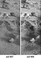
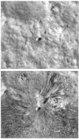
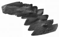
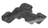
As an example, I've made a composite of the very last Surface Sampler activities at either Viking site. This is work done on Viking 2 sol 957 and imaged on sol 957 and 959. (someone can animate it if they like!) We see two separate trenching activities at the same place, and a soil dump (bottom) and a conical soil pile made by the second dump (middle). (more obvious in an animation, I just can't make one on this machine). Phil
-------------------- ... because the Solar System ain't gonna map itself.
Also to be found posting similar content on https://mastodon.social/@PhilStooke Maps for download (free PD: https://upload.wikimedia.org/wikipedia/comm...Cartography.pdf NOTE: everything created by me which I post on UMSF is considered to be in the public domain (NOT CC, public domain) |
|
 |
 
|
|
 |
|
Sep 4 2008, 06:47 PM
Post
#2
|
||
 Member Group: Members Posts: 646 Joined: 23-December 05 From: Forest of Dean Member No.: 617 |
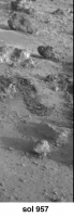
Attempt at an animation - not terribly good I'm afraid, I'm a clumsy beginner at this image processing lark.
-------------------- --
Viva software libre! |
|
|
|
|
|
| Guest_PhilCo126_* |
Sep 5 2008, 11:15 AM
Post
#3
|
|
Guests |
Great idea Phil... that will bring back some childhood memories.
1976 was a great year for a 10-year old 
|
|
|
|
|
Sep 5 2008, 01:13 PM
Post
#4
|
||
|
Solar System Cartographer Group: Members Posts: 10163 Joined: 5-April 05 From: Canada Member No.: 227 |
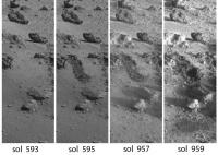
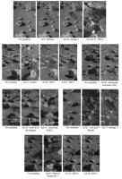
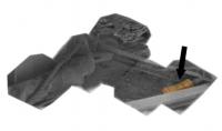
This is a set of four images documenting that last sampler activity. It is labelled with sol dates. The first trench was dug more than a year before the final digging event.
(EDIT: I have replaced the previous image with a corrected one, and fixed the text describing it) This last digging event came so late in the mission that it is not documented in the trench maps published by Hank Moore et al. If anyone knows a final trench map that includes it I'd be pleased to know about it. Otherwise I will be making one myself in due course. Note - images 2 and 3 show no surface difference, just different lighting. I will assemble other surface activity sequences like this, and I'd like to encourage others to join me. Phil
-------------------- ... because the Solar System ain't gonna map itself.
Also to be found posting similar content on https://mastodon.social/@PhilStooke Maps for download (free PD: https://upload.wikimedia.org/wikipedia/comm...Cartography.pdf NOTE: everything created by me which I post on UMSF is considered to be in the public domain (NOT CC, public domain) |
|
|
|
|
|
|
Sep 5 2008, 10:27 PM
Post
#5
|
|
 Interplanetary Dumpster Diver Group: Admin Posts: 4404 Joined: 17-February 04 From: Powell, TN Member No.: 33 |
Ricardo Nunes and I worked together on some images. I made the grayscale images and he did he color.
You can see them on his site under the "super resolution RGB" tab. You can also see his work under other tabs. http://www.astrosurf.com/nunes/explor/explor_vik.htm -------------------- |
|
|
|
|
Oct 13 2008, 07:21 PM
Post
#6
|
||
|
Solar System Cartographer Group: Members Posts: 10163 Joined: 5-April 05 From: Canada Member No.: 227 |
Here's a bit more Virtual Viking - reliving the Viking missions to make up for the impending loss of Phoenix.
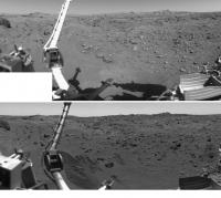
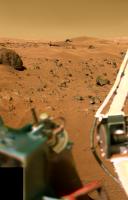
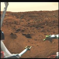
This is a comparison of the Viking 1 sample field - right side - seen before the arm operations began and after they ended. There are lots of changes - trenches dug, rocks moved, soil piles constructed (one at far left is on top of a rock). Phil
-------------------- ... because the Solar System ain't gonna map itself.
Also to be found posting similar content on https://mastodon.social/@PhilStooke Maps for download (free PD: https://upload.wikimedia.org/wikipedia/comm...Cartography.pdf NOTE: everything created by me which I post on UMSF is considered to be in the public domain (NOT CC, public domain) |
|
|
|
|
|
|
Oct 13 2008, 08:23 PM
Post
#7
|
||
|
Solar System Cartographer Group: Members Posts: 10163 Joined: 5-April 05 From: Canada Member No.: 227 |
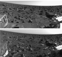
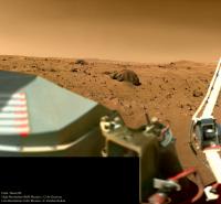
... and here's the left side of the Viking 1 workspace, before and after.
Phil
-------------------- ... because the Solar System ain't gonna map itself.
Also to be found posting similar content on https://mastodon.social/@PhilStooke Maps for download (free PD: https://upload.wikimedia.org/wikipedia/comm...Cartography.pdf NOTE: everything created by me which I post on UMSF is considered to be in the public domain (NOT CC, public domain) |
|
|
|
|
|
|
Oct 13 2008, 11:40 PM
Post
#8
|
|
 Senior Member Group: Members Posts: 1281 Joined: 18-December 04 From: San Diego, CA Member No.: 124 |
Thanks Phil these are quite nice....
-------------------- Lyford Rome
"Zis is not nuts, zis is super-nuts!" Mathematician Richard Courant on viewing an Orion test |
|
|
|
|
Oct 14 2008, 03:08 AM
Post
#9
|
||
|
Solar System Cartographer Group: Members Posts: 10163 Joined: 5-April 05 From: Canada Member No.: 227 |
I have just edited post 4 above - and replaced its image with a corrected version.
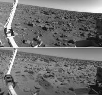
Here is the Viking 2 before and after trench image - right side of the workspace. Lots of frost spots in the lower image. Phil
-------------------- ... because the Solar System ain't gonna map itself.
Also to be found posting similar content on https://mastodon.social/@PhilStooke Maps for download (free PD: https://upload.wikimedia.org/wikipedia/comm...Cartography.pdf NOTE: everything created by me which I post on UMSF is considered to be in the public domain (NOT CC, public domain) |
|
|
|
|
|
|
Oct 14 2008, 03:10 AM
Post
#10
|
||
|
Solar System Cartographer Group: Members Posts: 10163 Joined: 5-April 05 From: Canada Member No.: 227 |
... and the left side...
Phil
-------------------- ... because the Solar System ain't gonna map itself.
Also to be found posting similar content on https://mastodon.social/@PhilStooke Maps for download (free PD: https://upload.wikimedia.org/wikipedia/comm...Cartography.pdf NOTE: everything created by me which I post on UMSF is considered to be in the public domain (NOT CC, public domain) |
|
|
|
|
|
|
Oct 14 2008, 03:59 AM
Post
#11
|
||
|
Solar System Cartographer Group: Members Posts: 10163 Joined: 5-April 05 From: Canada Member No.: 227 |
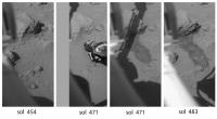
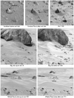
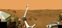
Here's another digging sequence from Viking 2. First, a view before anything happens. Then two views on sol 471, before and after a rock called Snow White was moved. The before image (left) also shows a disturbance just below the sampler arm, suggesting an arm touchdown on the surface some time between sols 454 and 471 (possibly on sol 471 just before the image was taken - but I can't find any documentation of it). The last image shows that the dark scrape made on sol 471 as the arm was retracted has been enlarged. This was the XRFS sample no. 12, but it failed to collect a proper sample.
Phil
EDIT - the touchdown in the second image was made just before the image was taken. The arm touched the surface, was raised up, then extended to push the rock. As it was retracted it scuffed the surface to leave a scrape mark seen in the third image. The XRFS trench was dug later, but the arm struck a buried rock and did not penetrate enough to collect a sample. Phil -------------------- ... because the Solar System ain't gonna map itself.
Also to be found posting similar content on https://mastodon.social/@PhilStooke Maps for download (free PD: https://upload.wikimedia.org/wikipedia/comm...Cartography.pdf NOTE: everything created by me which I post on UMSF is considered to be in the public domain (NOT CC, public domain) |
|
|
|
|
|
| Guest_PhilCo126_* |
Nov 15 2008, 02:41 PM
Post
#12
|
|
Guests |
Nice work, reading " A Passion for Mars " by Andrew Chaikin made me dug up some old treasures
 |
|
|
|
|
Nov 18 2008, 01:30 AM
Post
#13
|
||
|
Solar System Cartographer Group: Members Posts: 10163 Joined: 5-April 05 From: Canada Member No.: 227 |
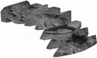
Here's a pic from Viking:
It's the full set of trench operations for Viking 2 in the primary mission. Phil -------------------- ... because the Solar System ain't gonna map itself.
Also to be found posting similar content on https://mastodon.social/@PhilStooke Maps for download (free PD: https://upload.wikimedia.org/wikipedia/comm...Cartography.pdf NOTE: everything created by me which I post on UMSF is considered to be in the public domain (NOT CC, public domain) |
|
|
|
|
|
|
Nov 18 2008, 03:56 AM
Post
#14
|
|
|
Interplanetary Dumpster Diver Group: Admin Posts: 4404 Joined: 17-February 04 From: Powell, TN Member No.: 33 |
Wow...I don't think I have ever seen those together. -------------------- |
|
|
|
| Guest_PhilCo126_* |
Nov 22 2008, 02:19 PM
Post
#15
|
|
Guests |
The goldmine(s) for Viking Lander images:
Lander Picture Catalogs of Experiment Data Record - NASA Reference Publication 1068 |
|
|
|
|
Nov 23 2008, 03:07 AM
Post
#16
|
|
|
Interplanetary Dumpster Diver Group: Admin Posts: 4404 Joined: 17-February 04 From: Powell, TN Member No.: 33 |
QUOTE (PhilCo126 @ Nov 22 2008, 02:19 PM)  The goldmine(s) for Viking Lander images: Lander Picture Catalogs of Experiment Data Record - NASA Reference Publication 1068 Why? The images are all on the PDS. -------------------- |
|
|
|
| Guest_PhilCo126_* |
Nov 23 2008, 12:56 PM
Post
#17
|
|
Guests |
|
|
|
|
|
Nov 23 2008, 05:08 PM
Post
#18
|
|
|
Founder Group: Chairman Posts: 14432 Joined: 8-February 04 Member No.: 1 |
|
|
|
|
|
Nov 23 2008, 05:16 PM
Post
#19
|
|
|
Solar System Cartographer Group: Members Posts: 10163 Joined: 5-April 05 From: Canada Member No.: 227 |
I prefer this source, from which images can be selected by sol, or by clicking on mosaics for each camera to select pictures of a given area.
http://pds-imaging.jpl.nasa.gov/vikingl/vl_images.html Phil -------------------- ... because the Solar System ain't gonna map itself.
Also to be found posting similar content on https://mastodon.social/@PhilStooke Maps for download (free PD: https://upload.wikimedia.org/wikipedia/comm...Cartography.pdf NOTE: everything created by me which I post on UMSF is considered to be in the public domain (NOT CC, public domain) |
|
|
|
|
Apr 21 2009, 02:23 PM
Post
#20
|
||
|
Solar System Cartographer Group: Members Posts: 10163 Joined: 5-April 05 From: Canada Member No.: 227 |
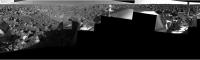
The Viking 1 site mapped in a new way... This is the polar projection of the landing site, which I posted some time ago, reprojected to HiRISE geometry. In this comparison, HiRISE is at the top and the reprojected Viking pan is below it. Mapping from ground-level images is very difficult, and grotesque distortions are inevitable, but this is the best I can do after several weeks and far too many iterations. The original is detailed enough to make a full photomap of the sampling area, and in that area the mosaic is controlled to fit the original mission map.
Phil
-------------------- ... because the Solar System ain't gonna map itself.
Also to be found posting similar content on https://mastodon.social/@PhilStooke Maps for download (free PD: https://upload.wikimedia.org/wikipedia/comm...Cartography.pdf NOTE: everything created by me which I post on UMSF is considered to be in the public domain (NOT CC, public domain) |
|
|
|
|
|
|
May 11 2009, 07:30 PM
Post
#21
|
||
|
Solar System Cartographer Group: Members Posts: 10163 Joined: 5-April 05 From: Canada Member No.: 227 |
I'm still perfecting that reprojected Viking 1 site map. Meanwhile here's a composite of images showing surface changes at the Viking 1 site. There were a few changes in soil patches on the lander itself as well, otherwise these were the only changes seen by Viking 1. For the first one, of course, the change I'm drawing attention to is the erosion by wind of Conical Pile 4 late in the mission. Several other artificial piles of soil were made and monitored but didn't change.
Phil
-------------------- ... because the Solar System ain't gonna map itself.
Also to be found posting similar content on https://mastodon.social/@PhilStooke Maps for download (free PD: https://upload.wikimedia.org/wikipedia/comm...Cartography.pdf NOTE: everything created by me which I post on UMSF is considered to be in the public domain (NOT CC, public domain) |
|
|
|
|
|
|
May 23 2009, 03:46 AM
Post
#22
|
||
|
Solar System Cartographer Group: Members Posts: 10163 Joined: 5-April 05 From: Canada Member No.: 227 |
Another of the things we can do so much better now than in the old days...
The Vikings carried mirrors on the sampler arm, and one of them could be viewed by one of the cameras to see underneath the lander. Seven images of the mirror were taken by Viking 1 on sols 528, 550, 582 and 594. They can be combined to produce a mosaic of the area underneath Engine 2 (the one right under the cameras) to look at the erosion effects of the engine during landing. The version made during Viking times was really bad! But now we can do it much better. This image contains two separate mosaics - they are supposed to fit together, but right now I don't have the old mosaic with me to compare and figure it out. They have been reversed to take the reflection into account and enlarged 2x. The bottom mosaic shows an erosion pit where loose soil has been blown away to reveal harder crusty stuff underneath. (EDIT: I found the location and fixed the mosaic) Phil
-------------------- ... because the Solar System ain't gonna map itself.
Also to be found posting similar content on https://mastodon.social/@PhilStooke Maps for download (free PD: https://upload.wikimedia.org/wikipedia/comm...Cartography.pdf NOTE: everything created by me which I post on UMSF is considered to be in the public domain (NOT CC, public domain) |
|
|
|
|
|
|
May 23 2009, 10:59 PM
Post
#23
|
||
|
Solar System Cartographer Group: Members Posts: 10163 Joined: 5-April 05 From: Canada Member No.: 227 |
Here's the Viking 2 mosaic underneath Engine 2. The images were taken on sols 57 and 555.
Phil
-------------------- ... because the Solar System ain't gonna map itself.
Also to be found posting similar content on https://mastodon.social/@PhilStooke Maps for download (free PD: https://upload.wikimedia.org/wikipedia/comm...Cartography.pdf NOTE: everything created by me which I post on UMSF is considered to be in the public domain (NOT CC, public domain) |
|
|
|
|
|
|
May 24 2009, 01:30 AM
Post
#24
|
|
|
Senior Member Group: Members Posts: 1281 Joined: 18-December 04 From: San Diego, CA Member No.: 124 |
Those are truly special, Phil!
-------------------- Lyford Rome
"Zis is not nuts, zis is super-nuts!" Mathematician Richard Courant on viewing an Orion test |
|
|
|
|
May 24 2009, 01:54 AM
Post
#25
|
|
|
Merciless Robot Group: Admin Posts: 8784 Joined: 8-December 05 From: Los Angeles Member No.: 602 |
They are indeed!
I'm gonna start saving my pennies for your forthcoming atlas...
-------------------- A few will take this knowledge and use this power of a dream realized as a force for change, an impetus for further discovery to make less ancient dreams real.
|
|
|
|
|
May 26 2009, 01:58 AM
Post
#26
|
|
|
Solar System Cartographer Group: Members Posts: 10163 Joined: 5-April 05 From: Canada Member No.: 227 |
I have edited my post above with the Viking 1 mirror mosaic - took out the old attachment and replaced it with one showing the two halves joined correctly. I found one 'accidental' mirror image from Viking 2 as well, that adds to coverage there, but I don't know exactly where the new frame fits. It doesn't actually overlap the mosaic. For reference these mirror mosaics cover an area roughly 20 by 60 cm across.
Phil -------------------- ... because the Solar System ain't gonna map itself.
Also to be found posting similar content on https://mastodon.social/@PhilStooke Maps for download (free PD: https://upload.wikimedia.org/wikipedia/comm...Cartography.pdf NOTE: everything created by me which I post on UMSF is considered to be in the public domain (NOT CC, public domain) |
|
|
|
|
May 28 2009, 09:07 PM
Post
#27
|
||
|
Solar System Cartographer Group: Members Posts: 10163 Joined: 5-April 05 From: Canada Member No.: 227 |
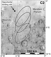
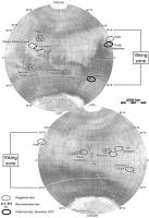
Another bit of Viking history now we are all thinking about the amazing views out past Endeavour crater in the Opportunity thread. After the Viking landing sites had been chosen in 1973 people began to have concerns about their safety. They looked for some extra-safe sites (as determined from earth-based radar) near the equator, the so-called C sites (A sites were at 20 north for the first mission, B sites at 44 north for the second mission. C would be used if A crashed or if all sites at those latitudes looked too rough in Viking images). C1 was just north of Capri Chasma, C3 at Schiaparelli crater, but C2 was at Meridiani. Here's a map showing three possible ellipses described in the minutes of the Landing Site Staff during Viking site certification in 1976. The top one just touched Endeavour crater.
Phil
-------------------- ... because the Solar System ain't gonna map itself.
Also to be found posting similar content on https://mastodon.social/@PhilStooke Maps for download (free PD: https://upload.wikimedia.org/wikipedia/comm...Cartography.pdf NOTE: everything created by me which I post on UMSF is considered to be in the public domain (NOT CC, public domain) |
|
|
|
|
|
|
May 29 2009, 12:23 AM
Post
#28
|
|
|
Merciless Robot Group: Admin Posts: 8784 Joined: 8-December 05 From: Los Angeles Member No.: 602 |
Fascinating (not a word I use lightly), Phil; did not know that.
One can only imagine how the Mars exploration strategy might have evolved had V1 landed in Meridiani on top of a nice piece of sedimentary pavement... -------------------- A few will take this knowledge and use this power of a dream realized as a force for change, an impetus for further discovery to make less ancient dreams real.
|
|
|
|
|
May 29 2009, 01:16 AM
Post
#29
|
|
|
Solar System Cartographer Group: Members Posts: 10163 Joined: 5-April 05 From: Canada Member No.: 227 |
There's a lot of good stuff in those committee minutes. My next step is to go through the Viking landing Site Working Group minutes from c. 1970-1974.
Phil -------------------- ... because the Solar System ain't gonna map itself.
Also to be found posting similar content on https://mastodon.social/@PhilStooke Maps for download (free PD: https://upload.wikimedia.org/wikipedia/comm...Cartography.pdf NOTE: everything created by me which I post on UMSF is considered to be in the public domain (NOT CC, public domain) |
|
|
|
|
May 29 2009, 10:19 AM
Post
#30
|
|
 Senior Member Group: Members Posts: 1088 Joined: 19-February 05 From: Close to Meudon Observatory in France Member No.: 172 |
QUOTE (Phil Stooke @ May 28 2009, 10:07 PM) Another bit of Viking history now we are all thinking about the amazing views out past Endeavour crater in the Opportunity thread. After the Viking landing sites had been chosen in 1973 people began to have concerns about their safety. They looked for some extra-safe sites (as determined from earth-based radar) near the equator, the so-called C sites (A sites were at 20 north for the first mission, B sites at 44 north for the second mission. C would be used if A crashed or if all sites at those latitudes looked too rough in Viking images). C1 was just north of Capri Chasma, C3 at Schiaparelli crater, but C2 was at Meridiani. Here's a map showing three possible ellipses described in the minutes of the Landing Site Staff during Viking site certification in 1976. The top one just touched Endeavour crater. Phil Thanks Phil ! And to complement your good info, here is what was written a while ago + how Meridiani would have looked to the Viking Lander camera. http://www.unmannedspaceflight.com/index.p...st&p=105769 Enjoy !
|
|
|
|
|
Jun 16 2009, 06:37 PM
Post
#31
|
||
|
Solar System Cartographer Group: Members Posts: 10163 Joined: 5-April 05 From: Canada Member No.: 227 |
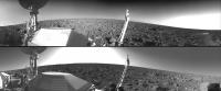
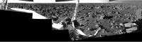
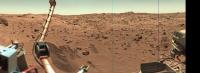
A good panorama for Viking 2 is hard to find. I have gone through the online CR-ROMs at PDS and extracted everything useful, and combined it here in one panoramic image.
For each camera I took morning and afternoon pans, and for camera 1 also a noon pan. Then, for each camera, I made a composite of the multiple views, with flaws or gaps in one fixed from one of the others. The tricky part after that was to combine Camera 1 and Camera 2. My intention is to mimimize obstructions by spacecraft components and maximize the visible surface, plus to combine the two views of the foreground into a full view of the sampling area. This cannot be done without introducing distortion in this view. Later I will rubbersheet the image to fit proper ground control for a photomap of the sampling field. Phil
-------------------- ... because the Solar System ain't gonna map itself.
Also to be found posting similar content on https://mastodon.social/@PhilStooke Maps for download (free PD: https://upload.wikimedia.org/wikipedia/comm...Cartography.pdf NOTE: everything created by me which I post on UMSF is considered to be in the public domain (NOT CC, public domain) |
|
|
|
|
|
|
Jun 16 2009, 07:41 PM
Post
#32
|
|
|
Merciless Robot Group: Admin Posts: 8784 Joined: 8-December 05 From: Los Angeles Member No.: 602 |
Everytime I look at the Viking sites I still marvel at how lucky we were. Beautiful work as always, Phil.
Quick question: How did you account for V2's site slope in this view? IIRC the lander had something like an 8-deg tilt, so would have expected a very shallow parabola across the top of the FOV. Was this sort of "washed out" by the distant topography in your rendering? Just curious, and forgive me if it's a silly question; my abject lack of image processing skills matches my lack of understanding of them! -------------------- A few will take this knowledge and use this power of a dream realized as a force for change, an impetus for further discovery to make less ancient dreams real.
|
|
|
|
|
Jun 16 2009, 08:22 PM
Post
#33
|
|
|
Solar System Cartographer Group: Members Posts: 10163 Joined: 5-April 05 From: Canada Member No.: 227 |
The tilt was already corrected for in the assembled panoramas I worked from. They were made at JPL and saved in a rather chaotic collection of archived files in the PDS. The hard part was finding suitable files to use.
Right now I'm trying to project the pan onto a HiRISE image to make a photomap. Phil -------------------- ... because the Solar System ain't gonna map itself.
Also to be found posting similar content on https://mastodon.social/@PhilStooke Maps for download (free PD: https://upload.wikimedia.org/wikipedia/comm...Cartography.pdf NOTE: everything created by me which I post on UMSF is considered to be in the public domain (NOT CC, public domain) |
|
|
|
|
Jun 16 2009, 09:49 PM
Post
#34
|
|
 The Poet Dude Group: Moderator Posts: 5551 Joined: 15-March 04 From: Kendal, Cumbria, UK Member No.: 60 |
Gorgeous pic Phil, great work as usual. I could - and probably will! - stare at that for yonks!
-------------------- |
|
|
|
|
Jun 17 2009, 03:26 PM
Post
#35
|
||
|
Solar System Cartographer Group: Members Posts: 10163 Joined: 5-April 05 From: Canada Member No.: 227 |
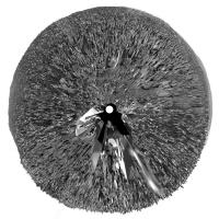
Here's the Viking 2 pan wrapped into a circle with exaggerated horizon relief - greatly exaggerated, or you don't see anything. I did this for Viking 1 a while ago.
Phil
-------------------- ... because the Solar System ain't gonna map itself.
Also to be found posting similar content on https://mastodon.social/@PhilStooke Maps for download (free PD: https://upload.wikimedia.org/wikipedia/comm...Cartography.pdf NOTE: everything created by me which I post on UMSF is considered to be in the public domain (NOT CC, public domain) |
|
|
|
|
|
|
Jun 17 2009, 04:10 PM
Post
#36
|
|
 Senior Member Group: Moderator Posts: 3431 Joined: 11-August 04 From: USA Member No.: 98 |
Awesome job on both.
|
|
|
|
|
Jun 26 2009, 03:08 PM
Post
#37
|
|
|
Interplanetary Dumpster Diver Group: Admin Posts: 4404 Joined: 17-February 04 From: Powell, TN Member No.: 33 |
Amazing!
-------------------- |
|
|
|
|
Jun 27 2009, 12:40 AM
Post
#38
|
|
|
Solar System Cartographer Group: Members Posts: 10163 Joined: 5-April 05 From: Canada Member No.: 227 |
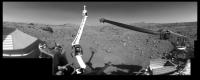
Thanks! I am doing some improvements to the panorama to get more uniform lighting - I just used the contemporary mosaics, now I'm making my own camera 2 pan with better morning lighting. Meanwhile, also working on step by step arm activity illustrations similar to some posted earlier. I must have Viking 2 finished by the end of July to stay on track.
Phil -------------------- ... because the Solar System ain't gonna map itself.
Also to be found posting similar content on https://mastodon.social/@PhilStooke Maps for download (free PD: https://upload.wikimedia.org/wikipedia/comm...Cartography.pdf NOTE: everything created by me which I post on UMSF is considered to be in the public domain (NOT CC, public domain) |
|
|
|
|
Jun 27 2009, 05:08 AM
Post
#39
|
|
|
Member Group: Members Posts: 279 Joined: 19-August 07 Member No.: 3299 |
Unique scenary. Surface is very rocky. That leads me to think on how lucky was Viking with landing!
|
|
|
|
|
Jun 29 2009, 09:02 PM
Post
#40
|
||
|
Senior Member Group: Members Posts: 1088 Joined: 19-February 05 From: Close to Meudon Observatory in France Member No.: 172 |
 As a tribute to Phil's gorgeous work, here is a VL2 controlled mosaic made in 2001 for a Mars educational exhibit built for the French section of the Mars Society... Enjoy ! As a tribute to Phil's gorgeous work, here is a VL2 controlled mosaic made in 2001 for a Mars educational exhibit built for the French section of the Mars Society... Enjoy !
|
|
|
|
|
|
|
Jun 29 2009, 09:16 PM
Post
#41
|
||
|
Senior Member Group: Members Posts: 1088 Joined: 19-February 05 From: Close to Meudon Observatory in France Member No.: 172 |
...and now for VL1 (especially made to show to the public the technical aspects of the robotic arm/soil sampler). Enjoy also !
|
|
|
|
|
|
|
Jun 30 2009, 02:25 AM
Post
#42
|
|
|
Merciless Robot Group: Admin Posts: 8784 Joined: 8-December 05 From: Los Angeles Member No.: 602 |
Those were AWESOME, VM, thanks!!!
Never, ever saw that V1 pan before; the arm was a beast indeed! -------------------- A few will take this knowledge and use this power of a dream realized as a force for change, an impetus for further discovery to make less ancient dreams real.
|
|
|
|
|
Jun 30 2009, 02:58 AM
Post
#43
|
|
|
Member Group: Members Posts: 279 Joined: 19-August 07 Member No.: 3299 |
Spectaculars pictures. The VL2 landing is terrific. How lucky was VL2. Thanks Vikingmars.
|
|
|
|
|
Jun 30 2009, 09:26 AM
Post
#44
|
|
|
Senior Member Group: Members Posts: 2920 Joined: 14-February 06 From: Very close to the Pyrénées Mountains (France) Member No.: 682 |
Merci Olivier... the quality of the panos is absolutely stuning
-------------------- |
|
|
|
|
Jul 1 2009, 03:46 AM
Post
#45
|
|
|
Solar System Cartographer Group: Members Posts: 10163 Joined: 5-April 05 From: Canada Member No.: 227 |
Speaking of Viking... next week I'm at Brown University, going through the papers of Tim Mutch in their archives. I'm looking for the minutes of the Viking Landing Site Working Group and related materials. Should be fun.
Phil -------------------- ... because the Solar System ain't gonna map itself.
Also to be found posting similar content on https://mastodon.social/@PhilStooke Maps for download (free PD: https://upload.wikimedia.org/wikipedia/comm...Cartography.pdf NOTE: everything created by me which I post on UMSF is considered to be in the public domain (NOT CC, public domain) |
|
|
|
|
Jul 1 2009, 05:01 AM
Post
#46
|
|
|
Merciless Robot Group: Admin Posts: 8784 Joined: 8-December 05 From: Los Angeles Member No.: 602 |
Ooo...gotta be some good stuff in there, Phil, happy hunting!
Admit that I'm most curious to know just how close they came to selecting Meridiani as the V1 landing site. -------------------- A few will take this knowledge and use this power of a dream realized as a force for change, an impetus for further discovery to make less ancient dreams real.
|
|
|
|
|
Jul 13 2009, 08:38 PM
Post
#47
|
|
|
Solar System Cartographer Group: Members Posts: 10163 Joined: 5-April 05 From: Canada Member No.: 227 |
OK, back from Providence with lots of goodies.
Nprev - they didn't get close to choosing site C2 - Meridiani. They had three sites at that latitude, Capri, Meridiani and Schiaparelli (C1, C2, C3), but they never considered any but C1 seriously. C1 was called Capri, but it was not in Capri Chasma, part of Valles Marineris. It was on the plateau north of the canyon. A similar site was considered for Mars '84, an ambitious rover mission. Phil -------------------- ... because the Solar System ain't gonna map itself.
Also to be found posting similar content on https://mastodon.social/@PhilStooke Maps for download (free PD: https://upload.wikimedia.org/wikipedia/comm...Cartography.pdf NOTE: everything created by me which I post on UMSF is considered to be in the public domain (NOT CC, public domain) |
|
|
|
|
Jul 13 2009, 09:30 PM
Post
#48
|
||
 Senior Member Group: Members Posts: 1637 Joined: 5-March 05 From: Boulder, CO Member No.: 184 |
QUOTE (Phil Stooke @ Jun 16 2009, 06:37 PM) A good panorama for Viking 2 is hard to find. I have gone through the online CR-ROMs at PDS and extracted everything useful, and combined it here in one panoramic image. For each camera I took morning and afternoon pans, and for camera 1 also a noon pan. Then, for each camera, I made a composite of the multiple views, with flaws or gaps in one fixed from one of the others. The tricky part after that was to combine Camera 1 and Camera 2. My intention is to mimimize obstructions by spacecraft components and maximize the visible surface, plus to combine the two views of the foreground into a full view of the sampling area. This cannot be done without introducing distortion in this view. Later I will rubbersheet the image to fit proper ground control for a photomap of the sampling field. Phil
Phil I assume you worked with hi-res images? For comparison at this MSSS link are some VL2 mosaics (bottom of page). These are later versions of the ones I worked on during my internship at JPL in 1977. http://www.msss.com/mars/pictures/viking_l...ing_lander.html I have just photographic prints/negatives of the earlier versions, unfortunately they aren't in digital form. Nice to hear you got a chance to look at Tim Mutch's papers. He was certainly a great person to have had the privilege of working with. -------------------- Steve [ my home page and planetary maps page ]
|
|
|
|
|
|
|
Jul 13 2009, 11:48 PM
Post
#49
|
|
|
Merciless Robot Group: Admin Posts: 8784 Joined: 8-December 05 From: Los Angeles Member No.: 602 |
Welcome back, and thanks for checking that out, Phil!
So, when's the book coming out? Gotta admit that the hindsight gained from everything since Viking makes the project's history even more fascinating. 'There were giants in those days!' -------------------- A few will take this knowledge and use this power of a dream realized as a force for change, an impetus for further discovery to make less ancient dreams real.
|
|
|
|
|
Jul 14 2009, 12:12 PM
Post
#50
|
|
|
Solar System Cartographer Group: Members Posts: 10163 Joined: 5-April 05 From: Canada Member No.: 227 |
My current plan is to submit the manuscript at the end of 2011, for publication a year later. That would be for Volume 1, up to Mars Express. Volume 2 would follow about 3 years later. But a final decision on a 1 or 2 volume format has not been made yet, and if it's a single large volume it will take 5-6 years.
Phil -------------------- ... because the Solar System ain't gonna map itself.
Also to be found posting similar content on https://mastodon.social/@PhilStooke Maps for download (free PD: https://upload.wikimedia.org/wikipedia/comm...Cartography.pdf NOTE: everything created by me which I post on UMSF is considered to be in the public domain (NOT CC, public domain) |
|
|
|
|
Aug 10 2009, 01:14 AM
Post
#51
|
||
|
Solar System Cartographer Group: Members Posts: 10163 Joined: 5-April 05 From: Canada Member No.: 227 |
Here's a little goodie from my visit to Brown University earlier this summer (and big thanks to everybody there for the help, both in the archives in the John Hay Library and in the RPIF).
This map shows the first serious effort to pick landing sites for Viking. If you read the NASA history volume 'On Mars', by Ezell and Ezell, those authors mention a meeting late in 1970 when the members of the Viking Landing Site Working Group proposed 'several lists of sites, including six by Carl Sagan'. But Ezell and Ezell don't identify the sites. I hoped to find the committee minutes, among Tim Mutch's papers in the archives. I did get to see his papers, but mostly material on Mars 1984 (a rover mission) plus some interesting personal things about his Himalayan expeditions before the one he died on. But in the RPIF I found - or rather Peter Nievert found for me - a real gem. Ezell and Ezell had written a much more complete account of the site selection process, in a hand-annotated typescript. It must have been condensed for the later history volume, but this version had all the missing bits in it - very nice indeed. So here is a map of those sites, chosen when the only spacecraft data were from Mariners 4, 6 and 7 (so plotted on a Mariner basemap). Phil
-------------------- ... because the Solar System ain't gonna map itself.
Also to be found posting similar content on https://mastodon.social/@PhilStooke Maps for download (free PD: https://upload.wikimedia.org/wikipedia/comm...Cartography.pdf NOTE: everything created by me which I post on UMSF is considered to be in the public domain (NOT CC, public domain) |
|
|
|
|
|
|
Nov 9 2009, 05:23 PM
Post
#52
|
||
 Member Group: Members Posts: 796 Joined: 27-February 08 From: Heart of Europe Member No.: 4057 |
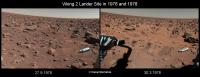
Viking 2 lander site in years 1976 and 1978.
Attached thumbnail(s)
-------------------- |
|
|
|
|
|
|
Nov 9 2009, 05:40 PM
Post
#53
|
||
|
Member Group: Members Posts: 796 Joined: 27-February 08 From: Heart of Europe Member No.: 4057 |
"High speed" panorama from Viking 1. Its low-res, not so good as from vikingmars (really awesome job!).
But its all around panorama.
Attached thumbnail(s)
-------------------- |
|
|
|
|
|
|
Nov 10 2009, 03:31 PM
Post
#54
|
||
|
Member Group: Members Posts: 796 Joined: 27-February 08 From: Heart of Europe Member No.: 4057 |
Morning on Mars from Viking 2 lander. First image was transferred to Earth without middle part.
Attached thumbnail(s)
-------------------- |
|
|
|
|
|
|
Nov 15 2009, 09:17 PM
Post
#55
|
||
|
Senior Member Group: Members Posts: 1637 Joined: 5-March 05 From: Boulder, CO Member No.: 184 |
QUOTE (scalbers @ Jul 13 2009, 09:30 PM) Phil I assume you worked with hi-res images? For comparison at this MSSS link are some VL2 mosaics (bottom of page). These are later versions of the ones I worked on during my internship at JPL in 1977. http://www.msss.com/mars/pictures/viking_l...ing_lander.html I have just photographic prints/negatives of the earlier versions, unfortunately they aren't in digital form. Nice to hear you got a chance to look at Tim Mutch's papers. He was certainly a great person to have had the privilege of working with. Here by the way is a montage of the quadrant pairs in the MSSS versions of the VL2 Camera 1 pm mosaic. These are less than the full resolution however they are corrected for the VL2 tilt.
Steve |
|
|
|
|
|
|
Nov 15 2009, 09:29 PM
Post
#56
|
||
|
Senior Member Group: Members Posts: 1637 Joined: 5-March 05 From: Boulder, CO Member No.: 184 |
...and the same for camera 2.
As a reminder I have links to the full resolution VL1 mosaics from the JPL photojournal about halfway down in this web page: https://stevealbers.net/albers/viking.html Also noted is Calvin Hamilton's mosaic from VL2 (full resolution, corrected for tilt). I had worked on VL2 hi-res mosaics for morning, noon, and afternoon with each camera (as available) so it would interesting to see these all assembled into one place. -------------------- Steve [ my home page and planetary maps page ]
|
|
|
|
|
|
|
Nov 15 2009, 11:19 PM
Post
#57
|
|
|
The Poet Dude Group: Moderator Posts: 5551 Joined: 15-March 04 From: Kendal, Cumbria, UK Member No.: 60 |
scalbers, Machi - just fantastic work, guys, genuinely thrilling to see those images. I wonder what amazing sights we'd enjoy if we - and by "we" I obviously mean geniuses like you! - went back through the all Viking data and used modern image processing techniques on the lesser-known images...
-------------------- |
|
|
|
|
Nov 16 2009, 01:09 AM
Post
#58
|
|
|
Senior Member Group: Members Posts: 1637 Joined: 5-March 05 From: Boulder, CO Member No.: 184 |
Stu - one "modern" thing I've long been interested in would be to combine low-res color information with the hi-res mosaic intensities. This might look pretty good if the lighting were close enough in each.
Steve |
|
|
|
|
Nov 16 2009, 03:54 AM
Post
#59
|
|
|
Solar System Cartographer Group: Members Posts: 10163 Joined: 5-April 05 From: Canada Member No.: 227 |
All these ideas are very good - and exactly what I was hoping to encourage when I started this thread. I'll dig out some more of my stuff too...
Phil -------------------- ... because the Solar System ain't gonna map itself.
Also to be found posting similar content on https://mastodon.social/@PhilStooke Maps for download (free PD: https://upload.wikimedia.org/wikipedia/comm...Cartography.pdf NOTE: everything created by me which I post on UMSF is considered to be in the public domain (NOT CC, public domain) |
|
|
|
|
Nov 16 2009, 10:51 AM
Post
#60
|
|
|
Member Group: Members Posts: 378 Joined: 21-April 05 From: Portugal Member No.: 347 |
QUOTE (scalbers @ Nov 16 2009, 02:09 AM) Stu - one "modern" thing I've long been interested in would be to combine low-res color information with the hi-res mosaic intensities. This might look pretty good if the lighting were close enough in each. Steve I've tried it and it's very hard to do. You have to correct the lowres color for tilt and camera distortions. Then, light doesn't match at all most of the time. My guess is that the best approach would be to reconstruct a full mosaic using only color images with consistent lighting and at the best possible resolution. -------------------- _______________________
www.astrosurf.com/nunes |
|
|
|
|
Nov 21 2009, 02:41 PM
Post
#61
|
||
|
Senior Member Group: Members Posts: 1637 Joined: 5-March 05 From: Boulder, CO Member No.: 184 |
Yes I can appreciate the hi-res color mosaics might be challenging, yet I believe the effort may be worthwhile. The hi-res is three times the angular resolution of the low-res so there is a significant gain in detail (9 times the pixels). I recall back in 1977 that this type of combining was done at least in the context of individual hi-res images and it looked pretty good. It was done at JPL/IPL using VICAR so any geometric corrections would have been doable (e.g. with the GEOCAM program).
I wonder if the original imagery can still be reprocessed with VICAR somehow. Otherwise something like IDL or other languages can fairly easily correct for camera tilt. The other camera distortions might require something like what VICAR/GEOCAM did if they are significant. If there are offsets in shadows then maybe a fancier program can be put together that would use "nearby" color information when needed. Looking online, here are some hi-res/low-res combo color images from Mary A. Dale-Bannister. Here's another one from Ricardo Nunes who also worked with Ted Stryk's super-resolution images as mentioned in post #5 of this thread. The black and white mosaics do have fairly consistent lighting, so I'm checking whether there are any wide angle panoramic color images (or mosaics) from similar times of day where this can be attempted. Using Phil's PDS link in post #19 I was able to construct this fairly wide angle low-res color view. I can see the lighting and geometry issues when matching to the hi-res mosaic. The missing vertical lines need to be filled in as well - there used to be a VICAR program called FILLVL to do this.
That's what I've found so far. Steve |
|
|
|
|
|
|
Jan 21 2010, 06:34 PM
Post
#62
|
|
|
Solar System Cartographer Group: Members Posts: 10163 Joined: 5-April 05 From: Canada Member No.: 227 |
Can anyone help me with this? I'm trying to find out how many images were taken by Viking Orbiter 1 and how many by Viking Orbiter 2. All I can find is the combined value.
Phil -------------------- ... because the Solar System ain't gonna map itself.
Also to be found posting similar content on https://mastodon.social/@PhilStooke Maps for download (free PD: https://upload.wikimedia.org/wikipedia/comm...Cartography.pdf NOTE: everything created by me which I post on UMSF is considered to be in the public domain (NOT CC, public domain) |
|
|
|
|
Jan 21 2010, 06:38 PM
Post
#63
|
|
 Administrator Group: Admin Posts: 5172 Joined: 4-August 05 From: Pasadena, CA, USA, Earth Member No.: 454 |
Sorting the CUMINDEX.TAB file for Viking Orbiter on SPACECRAFT_NAME, I get
34918 VIKING_ORBITER_1 15582 VIKING_ORBITER_2 Does this sound reasonable? -------------------- My website - My Patreon - @elakdawalla on Twitter - Please support unmannedspaceflight.com by donating here.
|
|
|
|
|
Jan 21 2010, 07:00 PM
Post
#64
|
|
|
Solar System Cartographer Group: Members Posts: 10163 Joined: 5-April 05 From: Canada Member No.: 227 |
That was quick! Thanks very much. Yes, very reasonable because VO1 lasted twice as long as VO2.
Phil -------------------- ... because the Solar System ain't gonna map itself.
Also to be found posting similar content on https://mastodon.social/@PhilStooke Maps for download (free PD: https://upload.wikimedia.org/wikipedia/comm...Cartography.pdf NOTE: everything created by me which I post on UMSF is considered to be in the public domain (NOT CC, public domain) |
|
|
|
|
Jan 21 2010, 07:07 PM
Post
#65
|
|
|
Solar System Cartographer Group: Members Posts: 10163 Joined: 5-April 05 From: Canada Member No.: 227 |
Just to follow up, that number may not include some approach views, calibration images, satellite and ring search images etc. (Yes, there was a satellite and ring search at some point fairly late in the mission) - but it seems to match the archived image totals - as of course the source would suggest it should. I have a suggestion that 1039 images are not included in those totals. That may also include some which were either lost in transmission, and lost or unreadable on the old tapes.
Phil -------------------- ... because the Solar System ain't gonna map itself.
Also to be found posting similar content on https://mastodon.social/@PhilStooke Maps for download (free PD: https://upload.wikimedia.org/wikipedia/comm...Cartography.pdf NOTE: everything created by me which I post on UMSF is considered to be in the public domain (NOT CC, public domain) |
|
|
|
|
Jan 21 2010, 07:36 PM
Post
#66
|
|
|
Administrator Group: Admin Posts: 5172 Joined: 4-August 05 From: Pasadena, CA, USA, Earth Member No.: 454 |
It includes the following:
547 VO1 images targeted at "STAR" or "MARS" during cruise -- there's your approach and calibration images; 8 VO1 images of the bicentennial emblem; I don't see any VO2 approach "STAR" images, but there are the PRE_ORBIT images of MARS, 91 of them. One thing I know for sure that the PDS archive does not include is the Earth-Moon departure images. I tried to inquire with someone at the geosciences node about these but I don't think she understood that I was looking for original data, not cruddy old press-release images; she didn't seem interested in pursuing them. You can explore the file for yourself here: ftp://pdsimage2.wr.usgs.gov/cdroms/viking.../vo_1064/index/ (cumindex.tab and cumindex.lbl) --Emily -------------------- My website - My Patreon - @elakdawalla on Twitter - Please support unmannedspaceflight.com by donating here.
|
|
|
|
|
Jan 21 2010, 07:51 PM
Post
#67
|
|
|
Solar System Cartographer Group: Members Posts: 10163 Joined: 5-April 05 From: Canada Member No.: 227 |
Thanks again!
Phil -------------------- ... because the Solar System ain't gonna map itself.
Also to be found posting similar content on https://mastodon.social/@PhilStooke Maps for download (free PD: https://upload.wikimedia.org/wikipedia/comm...Cartography.pdf NOTE: everything created by me which I post on UMSF is considered to be in the public domain (NOT CC, public domain) |
|
|
|
|
Jan 28 2010, 06:21 PM
Post
#68
|
||
|
Solar System Cartographer Group: Members Posts: 10163 Joined: 5-April 05 From: Canada Member No.: 227 |
This is an image that, as far as I know, has never been compiled or published before. Earlier I posted mosaics of images taken underneath the two Viking landers using small mirrors on the sampler arm. This is another one. It's from Viking Lander 2, showing images taken over three sols far apart in the mission, looking at the area near Footpad 2. This footpad carried a temperature sensor. They needed to know if it was buried or not - Viking 1's was buried, this one is not. The sensor is near the right end of the mosaic, but I couldn't tell you which object it is.
Phil (EDIT: I changed 'left' to 'right' in the last sentence - it's correct now. I forgot I had flipped it to remove the mirror reversal.)
-------------------- ... because the Solar System ain't gonna map itself.
Also to be found posting similar content on https://mastodon.social/@PhilStooke Maps for download (free PD: https://upload.wikimedia.org/wikipedia/comm...Cartography.pdf NOTE: everything created by me which I post on UMSF is considered to be in the public domain (NOT CC, public domain) |
|
|
|
|
|
|
Jan 28 2010, 07:37 PM
Post
#69
|
|
|
Senior Member Group: Members Posts: 1281 Joined: 18-December 04 From: San Diego, CA Member No.: 124 |
Very cool - I have been transported in time AND space!

-------------------- Lyford Rome
"Zis is not nuts, zis is super-nuts!" Mathematician Richard Courant on viewing an Orion test |
|
|
|
|
Jan 30 2010, 12:05 AM
Post
#70
|
||
|
Senior Member Group: Members Posts: 1088 Joined: 19-February 05 From: Close to Meudon Observatory in France Member No.: 172 |
QUOTE (Phil Stooke @ Jan 28 2010, 07:21 PM) .../... but I couldn't tell you which object it is. Phil Phil, I'm pretty sure : this is the temp sensor
|
|
|
|
|
|
|
Jan 30 2010, 12:07 AM
Post
#71
|
|
|
Senior Member Group: Members Posts: 1088 Joined: 19-February 05 From: Close to Meudon Observatory in France Member No.: 172 |
...And by the way, phil : you did a GREAT work !
|
|
|
|
|
Jan 30 2010, 09:03 AM
Post
#72
|
|
|
Member Group: Members Posts: 890 Joined: 18-November 08 Member No.: 4489 |
i would say that the temp sencer is this ( in red ) and it's cable ( in green )
[attachment=20535:vik2_foo...d_images.png] |
|
|
|
|
Jun 1 2010, 03:51 PM
Post
#73
|
||
|
Solar System Cartographer Group: Members Posts: 10163 Joined: 5-April 05 From: Canada Member No.: 227 |
Here is the comparable mosaic of images of the footpad temperature sensor from Viking 1. This sensor, on Footpad 2, was found to be buried (or partly buried?) in the fine drift material which covered the footpad itself. Like the Viking 2 mosaic, I don't think this was ever previously assembled like this and published. The images were taken on sols 40, 203 and 520.
Phil
-------------------- ... because the Solar System ain't gonna map itself.
Also to be found posting similar content on https://mastodon.social/@PhilStooke Maps for download (free PD: https://upload.wikimedia.org/wikipedia/comm...Cartography.pdf NOTE: everything created by me which I post on UMSF is considered to be in the public domain (NOT CC, public domain) |
|
|
|
|
|
|
Dec 11 2010, 04:18 PM
Post
#74
|
||
|
Junior Member Group: Members Posts: 22 Joined: 9-December 10 Member No.: 5551 |
Hello,
Thank you all, especially those that process and share their pictures ! Oliver, The Viking High-resolution panorama are magnificent !! The few Viking Lander high-resolution color images of good quality that I saw were also Olivier : VL1: visions-mars07-1280x1024.jpg visions-mars07-1440x900.jpg Goursac-Mars8.jpg visions-mars08-1280x1024.jpg visions-mars08-1440x900.jpg Goursac-Mars11.jpg pano_sunset.jpg evening2.jpg VL1_morning_evening.jpg VL2 : Goursac-Mars15.jpg Goursac-Mars13.jpg visions-mars09-1280x1024.jpg visions-mars09-1440x900.jpg There are also "old" cited in post # 61: http://nssdc.gsfc.nasa.gov/photo_gallery/p...rs.html#surface But quality is not perfect ... QUOTE (scalbers @ Nov 21 2009, 02:41 PM) Here's another one from Ricardo Nunes who also worked with Ted Stryk's super-resolution images as mentioned in post #5 of this thread. So I tried (for testing) the assembly of the luminance of the panorama of Olivier (post # 41) and the color of the Scalbers image (Post # 61), it is not perfect for several reasons: - There is not color image with the arm in this position - Several holes and pebbles are moved between the two. - The sun is not at the same position. But in a small piece, This is not bad :
now I try to make a low-resolution color panorama which corresponds more to high-resolution panorama ... To be continued ... |
|
|
|
|
|
|
Dec 11 2010, 04:25 PM
Post
#75
|
|
 Senior Member Group: Admin Posts: 4763 Joined: 15-March 05 From: Glendale, AZ Member No.: 197 |
QUOTE (Vanden @ Dec 11 2010, 08:18 AM) now I try to make a low-resolution color panorama which corresponds more to high-resolution panorama ... To be continued ... Thanks for sharing your nice work Vanden. Next time please post your image as an attachment rather than a link to the full image. (your post above has been edited to do so.) A lot of people use slow connections or browse with their handhold phones and these large images can present a problem. Best to give people the choice of viewing the entire image. -------------------- If Occam had heard my theory, things would be very different now.
|
|
|
|
|
Dec 11 2010, 04:35 PM
Post
#76
|
||
|
Junior Member Group: Members Posts: 22 Joined: 9-December 10 Member No.: 5551 |
QUOTE (ElkGroveDan @ Dec 11 2010, 05:25 PM) Thanks for sharing your nice work Vanden. Next time please post your image as an attachment rather than a link to the full image. (your post above has been edited to do so.) A lot of people use slow connections or browse with their handhold phones and these large images can present a problem. Best to give people the choice of viewing the entire image. Ok, I had not seen ... Here is my low resolution color panorama :
|
|
|
|
|
|
|
Dec 13 2010, 01:09 AM
Post
#77
|
||
|
Junior Member Group: Members Posts: 22 Joined: 9-December 10 Member No.: 5551 |
And here a portion of the assembly :
|
|
|
|
|
|
|
Dec 13 2010, 01:14 AM
Post
#78
|
|
|
Merciless Robot Group: Admin Posts: 8784 Joined: 8-December 05 From: Los Angeles Member No.: 602 |
Beautiful. Thanks!
Always love looking at Big Joe...wonder how he looks now. IIRC, V1 observed that a small part of his sand-cap fell off at one point. -------------------- A few will take this knowledge and use this power of a dream realized as a force for change, an impetus for further discovery to make less ancient dreams real.
|
|
|
|
|
Dec 13 2010, 03:42 AM
Post
#79
|
|
|
Solar System Cartographer Group: Members Posts: 10163 Joined: 5-April 05 From: Canada Member No.: 227 |
Not his cap but the drift at his base!
Phil -------------------- ... because the Solar System ain't gonna map itself.
Also to be found posting similar content on https://mastodon.social/@PhilStooke Maps for download (free PD: https://upload.wikimedia.org/wikipedia/comm...Cartography.pdf NOTE: everything created by me which I post on UMSF is considered to be in the public domain (NOT CC, public domain) |
|
|
|
|
Dec 13 2010, 04:13 AM
Post
#80
|
|
|
Merciless Robot Group: Admin Posts: 8784 Joined: 8-December 05 From: Los Angeles Member No.: 602 |
Was it? I always thought that a piece of the cap fell off & impacted the base dune, but by now I should know better than to trust a 30+ yr.-old memory.
(My God...I'm old now!!!)  Thanks, Phil.
-------------------- A few will take this knowledge and use this power of a dream realized as a force for change, an impetus for further discovery to make less ancient dreams real.
|
|
|
|
|
Dec 13 2010, 05:01 AM
Post
#81
|
|
|
Solar System Cartographer Group: Members Posts: 10163 Joined: 5-April 05 From: Canada Member No.: 227 |
The only visible change was at the base, no change on top, so that can't be right. I'll post pics tomorrow.
Phil -------------------- ... because the Solar System ain't gonna map itself.
Also to be found posting similar content on https://mastodon.social/@PhilStooke Maps for download (free PD: https://upload.wikimedia.org/wikipedia/comm...Cartography.pdf NOTE: everything created by me which I post on UMSF is considered to be in the public domain (NOT CC, public domain) |
|
|
|
|
Dec 13 2010, 06:17 AM
Post
#82
|
|
|
Merciless Robot Group: Admin Posts: 8784 Joined: 8-December 05 From: Los Angeles Member No.: 602 |
Oh, I believe you, man; love to see the pics!
As I recall, NASA stated that this was the first example of small-scale natural erosion on another world ever observed (actually, unless the MERs or Pathfinder saw something as well it might still be the only one. Not sure if the sublimation seen by Phoenix counts, and can't call the polar landslides "small-scale".) -------------------- A few will take this knowledge and use this power of a dream realized as a force for change, an impetus for further discovery to make less ancient dreams real.
|
|
|
|
|
Dec 13 2010, 08:08 AM
Post
#83
|
|
|
Senior Member Group: Admin Posts: 4763 Joined: 15-March 05 From: Glendale, AZ Member No.: 197 |
QUOTE (nprev @ Dec 12 2010, 10:17 PM) (actually, unless the MERs or Pathfinder saw something as well it might still be the only one. ) Regardless of the cause, the fresh gullies identified with MGS probably should be included, and some of them are very small. I guess it's all about where you draw the line and what falls in the category of erosion. Certainly the disappearing rover tracks is a form of natural erosion. -------------------- If Occam had heard my theory, things would be very different now.
|
|
|
|
|
Dec 13 2010, 12:13 PM
Post
#84
|
|
|
Solar System Cartographer Group: Members Posts: 10163 Joined: 5-April 05 From: Canada Member No.: 227 |
Viking 1 saw a second similar change later, as well. Spirit saw the little dust ripples move during a dust storm, with a nice animation posted on here at the time. We also saw tracks filling in with dust where we crossed old tracks (Home Plate, exiting Endurance, etc.) Pathfinder wasn't on the surface long enough to catch anything, and normally the MER rovers were not in one place long enough to see any changes.
Phil -------------------- ... because the Solar System ain't gonna map itself.
Also to be found posting similar content on https://mastodon.social/@PhilStooke Maps for download (free PD: https://upload.wikimedia.org/wikipedia/comm...Cartography.pdf NOTE: everything created by me which I post on UMSF is considered to be in the public domain (NOT CC, public domain) |
|
|
|
|
Dec 13 2010, 02:43 PM
Post
#85
|
||
|
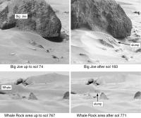
Solar System Cartographer Group: Members Posts: 10163 Joined: 5-April 05 From: Canada Member No.: 227 |
Here are the two Viking 1 changes with a little bit of super-resolution to sharpen them. This is from the forthcoming Mars Exploration atlas - first draft now finished.
Phil
-------------------- ... because the Solar System ain't gonna map itself.
Also to be found posting similar content on https://mastodon.social/@PhilStooke Maps for download (free PD: https://upload.wikimedia.org/wikipedia/comm...Cartography.pdf NOTE: everything created by me which I post on UMSF is considered to be in the public domain (NOT CC, public domain) |
|
|
|
|
|
|
Dec 13 2010, 08:42 PM
Post
#86
|
|
|
Solar System Cartographer Group: Members Posts: 10163 Joined: 5-April 05 From: Canada Member No.: 227 |
I should add that the Viking Lander imagery is ripe for re-analysis, looking for smaller overlooked changes. It can be tricky getting the lighting similar enough, but there's lots to do here.
Phil -------------------- ... because the Solar System ain't gonna map itself.
Also to be found posting similar content on https://mastodon.social/@PhilStooke Maps for download (free PD: https://upload.wikimedia.org/wikipedia/comm...Cartography.pdf NOTE: everything created by me which I post on UMSF is considered to be in the public domain (NOT CC, public domain) |
|
|
|
|
Dec 14 2010, 01:49 AM
Post
#87
|
|
|
Merciless Robot Group: Admin Posts: 8784 Joined: 8-December 05 From: Los Angeles Member No.: 602 |
Awesome. I forgot all about the Whale slump.
Thanks, Phil; anxiously awaiting publication of your atlas!!!
-------------------- A few will take this knowledge and use this power of a dream realized as a force for change, an impetus for further discovery to make less ancient dreams real.
|
|
|
|
|
Jan 13 2011, 06:03 PM
Post
#88
|
||
|
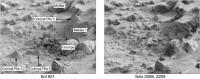
Solar System Cartographer Group: Members Posts: 10163 Joined: 5-April 05 From: Canada Member No.: 227 |
Here's another comparison image showing changes at the VL1 site:
Conical Piles 2, 3 and 5 were constructed to see if wind would erode them during the mission. In the long automated mode imaging period late in the mission, one of the targets they covered was this area with three soil piles. Sure enough, more than 2000 sols into the mission, all three piles were found to have disappeared. Ray Arvidson et al. described the change in a paper in Science in 1983. Phil -------------------- ... because the Solar System ain't gonna map itself.
Also to be found posting similar content on https://mastodon.social/@PhilStooke Maps for download (free PD: https://upload.wikimedia.org/wikipedia/comm...Cartography.pdf NOTE: everything created by me which I post on UMSF is considered to be in the public domain (NOT CC, public domain) |
|
|
|
|
|
|
Jan 13 2011, 06:22 PM
Post
#89
|
|
|
The Poet Dude Group: Moderator Posts: 5551 Joined: 15-March 04 From: Kendal, Cumbria, UK Member No.: 60 |
That's fascinating Phil, thanks. I honestly wasn't aware they'd even done that.
-------------------- |
|
|
|
|
Jan 15 2011, 11:45 PM
Post
#90
|
|
|
Senior Member Group: Members Posts: 1637 Joined: 5-March 05 From: Boulder, CO Member No.: 184 |
QUOTE (Vanden @ Dec 13 2010, 01:09 AM) And here a portion of the assembly: Vanden, very nice to see your efforts as I'm catching up on this thread. Glad to see the lowres / hires combination is working. Seeing all the details that Viking showed, and in color really does better justice to the imagery. -------------------- Steve [ my home page and planetary maps page ]
|
|
|
|
|
Jan 17 2011, 05:21 AM
Post
#91
|
|||
|
Senior Member Group: Members Posts: 1088 Joined: 19-February 05 From: Close to Meudon Observatory in France Member No.: 172 |
QUOTE (Vanden @ Dec 13 2010, 02:09 AM) And here a portion of the assembly : How nice Vanden ! Your work is just GREAT (and thanks for your nice quote). To help you, here are some versions I made in 2001 extracting the colors from a low-res (BLU, GRN and RED diodes) mosaic and paste them on the b&w hi-res BB3 & BB4 diodes mosaic (one of the versions you know already). For the "Sandy Flats" pic (the one you are working on), was added a low-res BLU diode "sky dynamics" image above the meteorological mast (pic taken earlier). => Your results show really good improvements in color quality and paste... Congratulations to you !
|
||
|
|
|
||
|
Jan 17 2011, 08:49 PM
Post
#92
|
||
|
Senior Member Group: Members Posts: 1088 Joined: 19-February 05 From: Close to Meudon Observatory in France Member No.: 172 |
...And another one, done using the same techniques, and just found in my archives. Enjoy too !
|
|
|
|
|
|
|
Jan 18 2011, 01:43 AM
Post
#93
|
|
 Member Group: Members Posts: 399 Joined: 28-August 07 From: San Francisco Member No.: 3511 |
Tremendous, I really dig that last one...
... thanks for posting... -------------------- 'She drove until the wheels fell off...'
|
|
|
|
|
Feb 23 2011, 12:10 AM
Post
#94
|
|
|
Junior Member Group: Members Posts: 22 Joined: 9-December 10 Member No.: 5551 |
Thank you for these images and explanations.
I like see "new" images of old missions !! Here is the complete panorama : 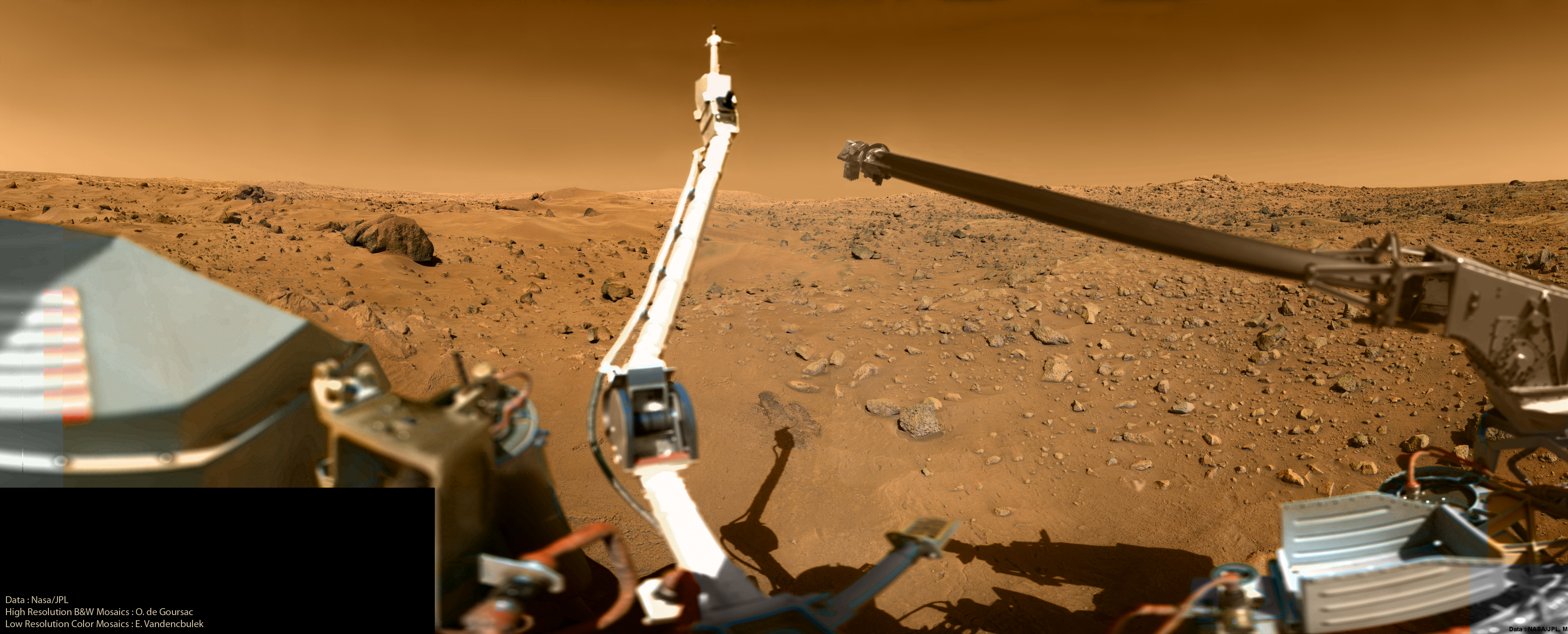
|
|
|
|
| Guest_Oersted_* |
Feb 23 2011, 09:35 AM
Post
#95
|
|
Guests |
Wauw! to that complete panorama, new desktop!
|
|
|
|
|
Feb 23 2011, 11:15 AM
Post
#96
|
|
|
Member Group: Members Posts: 796 Joined: 27-February 08 From: Heart of Europe Member No.: 4057 |
Finally full size, high-res, color panorama from Viking. Spectacular!

-------------------- |
|
|
|
|
Feb 26 2011, 09:25 PM
Post
#97
|
|
|
Senior Member Group: Members Posts: 1088 Joined: 19-February 05 From: Close to Meudon Observatory in France Member No.: 172 |
QUOTE (Vanden @ Feb 23 2011, 01:10 AM) ... Here is the complete panorama :[url="http://infonetservices02.chez.com/VL1_Cam1_Color_HD.jpg"] Thanks Vanden : how nice to see my old b&w mosaic now in full colors, thanks to your wonderful work. You did it greeeaaaat !!! to you !
|
|
|
|
|
Jul 7 2011, 05:55 PM
Post
#98
|
|
|
Solar System Cartographer Group: Members Posts: 10163 Joined: 5-April 05 From: Canada Member No.: 227 |
A little experiment. This is a super-resolution composite of five HiRISE images of Viking Lander 2.
Phil  -------------------- ... because the Solar System ain't gonna map itself.
Also to be found posting similar content on https://mastodon.social/@PhilStooke Maps for download (free PD: https://upload.wikimedia.org/wikipedia/comm...Cartography.pdf NOTE: everything created by me which I post on UMSF is considered to be in the public domain (NOT CC, public domain) |
|
|
|
|
Jul 7 2011, 06:28 PM
Post
#99
|
|
|
Senior Member Group: Admin Posts: 4763 Joined: 15-March 05 From: Glendale, AZ Member No.: 197 |
Wow. That is sharp.
-------------------- If Occam had heard my theory, things would be very different now.
|
|
|
|
|
Feb 23 2013, 09:09 PM
Post
#100
|
||
|
Senior Member Group: Members Posts: 1088 Joined: 19-February 05 From: Close to Meudon Observatory in France Member No.: 172 |
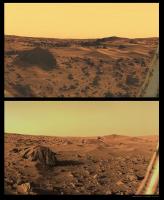
When I processed and built the Curiosity dusk panorama
http://www.unmannedspaceflight.com/index.p...st&p=198007 , I knew that a similar imaging experiment was done during the Viking Lander 1 mission. It was ordered by Carl Sagan himself who was a Member of the Lander Imaging team and who wanted to see how the Martian landscape looked like at dusk... Here is his panoramic picture taken on Sols 163 and 164 (BB4 diode), fully processed and colorized using the real colors retrieved from images taken at sunset. A tribute to Carl Sagan and to the Planetary Society. Enjoy !
PS : The darkest band in the sky close to the horizon is real : its shows the shadow of the planet Mars reaching out in space 180° away from the Sun... |
|
|
|
|
|
 |

|
Lo-Fi Version | Time is now: 18th May 2024 - 03:34 PM |
|
RULES AND GUIDELINES Please read the Forum Rules and Guidelines before posting. IMAGE COPYRIGHT |
OPINIONS AND MODERATION Opinions expressed on UnmannedSpaceflight.com are those of the individual posters and do not necessarily reflect the opinions of UnmannedSpaceflight.com or The Planetary Society. The all-volunteer UnmannedSpaceflight.com moderation team is wholly independent of The Planetary Society. The Planetary Society has no influence over decisions made by the UnmannedSpaceflight.com moderators. |
SUPPORT THE FORUM Unmannedspaceflight.com is funded by the Planetary Society. Please consider supporting our work and many other projects by donating to the Society or becoming a member. |
|