MSL Route Map |

  |
MSL Route Map |
 Sep 18 2012, 05:57 PM Sep 18 2012, 05:57 PM
Post
#31
|
||
|
Junior Member  Group: Members Posts: 31 Joined: 10-August 12 Member No.: 6526 |
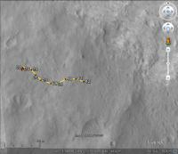
Here's an estimate for Sol 42. It's easier to identify some of these ground features when viewing in 3D.
 Sol_42.kmz ( 1.1K )
Number of downloads: 2101
Sol_42.kmz ( 1.1K )
Number of downloads: 2101Mark |
|
 |
 
|
|
|
Sep 18 2012, 06:18 PM
Post
#32
|
||
|
Solar System Cartographer Group: Members Posts: 10229 Joined: 5-April 05 From: Canada Member No.: 227 |
I got the same location!
Phil
-------------------- ... because the Solar System ain't gonna map itself.
Also to be found posting similar content on https://mastodon.social/@PhilStooke Maps for download (free PDF: https://upload.wikimedia.org/wikipedia/comm...Cartography.pdf NOTE: everything created by me which I post on UMSF is considered to be in the public domain (NOT CC, public domain) |
|
|
|
|
|
|
Sep 18 2012, 08:09 PM
Post
#33
|
|
|
Newbie Group: Members Posts: 1 Joined: 10-August 12 Member No.: 6531 |
Could you add a scale bar to the route map? That would be really helpful in understanding it.

|
|
|
|
|
Sep 18 2012, 08:27 PM
Post
#34
|
|
 Member Group: Members Posts: 276 Joined: 11-December 07 From: Dar es Salaam, Tanzania Member No.: 3978 |
Not to worry Hanno, Phil has promised that. BTW welcome to UMSF.com seeing it is your first post!
-------------------- |
|
|
|
|
Sep 18 2012, 08:44 PM
Post
#35
|
|
|
Solar System Cartographer Group: Members Posts: 10229 Joined: 5-April 05 From: Canada Member No.: 227 |
I'll get to it, but it helps to recall from the JPL news updates that the longer drive segments are generally about 30-35 m long.
My intention is to work on these maps at a standard scale with a 100 m grid superimposed. For areas with a lot of activity in a small area I will make more detailed maps at a larger scale, with a scale bar. The current map is between the two scales and I'm working on a different version for later, but right now I want to keep using this high contrast enlarged HiRISE base. Phil -------------------- ... because the Solar System ain't gonna map itself.
Also to be found posting similar content on https://mastodon.social/@PhilStooke Maps for download (free PDF: https://upload.wikimedia.org/wikipedia/comm...Cartography.pdf NOTE: everything created by me which I post on UMSF is considered to be in the public domain (NOT CC, public domain) |
|
|
|
|
Sep 18 2012, 08:51 PM
Post
#36
|
|
 Senior Member Group: Members Posts: 3419 Joined: 9-February 04 From: Minneapolis, MN, USA Member No.: 15 |
I know I have been assuming standard map orientation with North up, West to the left, etc., etc. Assuming the HiRISE image was taken in the afternoon, that would be consistent with the lighting.
Obviously, if we need to slew a map around for ease of demonstrating a particular route (as I can imagine may be needful when we get around to things like driving up a drywash cut canyonlike into the lower mound), it would be nice to see a compass rose somewhere, just for general orientation... and to help people like me find things when someone says "it's just west of the Sol 24 position."  -the other Doug -------------------- The trouble ain't that there is too many fools, but that the lightning ain't distributed right. -Mark Twain
|
|
|
|
|
Sep 18 2012, 10:25 PM
Post
#37
|
||
|
Senior Member Group: Moderator Posts: 4279 Joined: 19-April 05 From: .br at .es Member No.: 253 |
Here's my version of route map for Google Earth / Mars.
Route_Map_Sol42.kmz ( 1.16K )
Number of downloads: 2066Phil, slight differences on the sol locations aside, I see that the route on your map have a rotation of a few degrees (five?) when compared to mine and the same happens to the HiRISE background. I'm using the map-projected version of ESP_028401_1755 as a reference to register the polar mosaics and which is presumed to have North up. What do you think? 
|
|
|
|
|
|
|
Sep 18 2012, 10:32 PM
Post
#38
|
|
|
Solar System Cartographer Group: Members Posts: 10229 Joined: 5-April 05 From: Canada Member No.: 227 |
I'm using a map-projected image as well, but a pre-landing one chosen to be almost vertical (I don't have the file name with me right now). The incidence angle might cause an apparent rotation on sloping ground. And map projection might be based on a different central meridian or based on a preliminary ephemeris.
Phil -------------------- ... because the Solar System ain't gonna map itself.
Also to be found posting similar content on https://mastodon.social/@PhilStooke Maps for download (free PDF: https://upload.wikimedia.org/wikipedia/comm...Cartography.pdf NOTE: everything created by me which I post on UMSF is considered to be in the public domain (NOT CC, public domain) |
|
|
|
|
Sep 18 2012, 10:52 PM
Post
#39
|
||
|
Member Group: Members Posts: 252 Joined: 5-May 05 From: Mississippi (USA) Member No.: 379 |
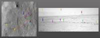
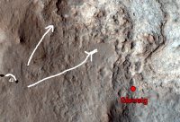
QUOTE (markril @ Sep 18 2012, 12:57 PM)  It's easier to identify some of these ground features when viewing in 3D. Mark Definitly true in my case, once I created a Anaglyph and compared it to Marks visual explanation. (see below) http://www.unmannedspaceflight.com/index.p...st&id=28176 I hope this down and dirty Anaglyph provides some context for other people.
What I am not certain about is that this view is toward the NE. Also that mid distance could be described as a view of the northern portion of Glenelg. If I was a sailor I would describe my method as dead reckoning. I am not going to have time for much else. Back when Spirit was climbing Husband Hill I dead reckoned myself down and about 50 meters back out onto the plains before I was totally convinced I was completely lost! Jack EDIT Changed SE to NE. Thank you markril! |
|
|
|
|
|
|
Sep 18 2012, 11:22 PM
Post
#40
|
|
|
Junior Member Group: Members Posts: 31 Joined: 10-August 12 Member No.: 6526 |
FWIW, I've been using the orthoimages from this DTM page:
http://hirise.lpl.arizona.edu/dtm/dtm.php?ID=PSP_010573_1755 Specifically: PSP_010573_1755_RED_A_01_ORTHO PSP_010639_1755_RED_A_01_ORTHO They are map-projected, but are also adjusted using the DTM data to be a view looking directly down. Mark P.S. Jack, that view is looking NE...
|
|
|
|
|
Sep 19 2012, 12:29 AM
Post
#41
|
||
 Senior Member Group: Members Posts: 1465 Joined: 9-February 04 From: Columbus OH USA Member No.: 13 |
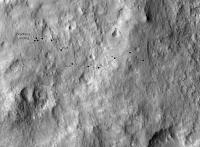
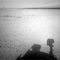
Could rover shadows be used to get a rough fix? For example this shot:
http://mars.jpl.nasa.gov/msl/multimedia/ra...0427M_&s=42 NASA does mark the UTC time of the shots (one of the few bits of shooting conditions given), in this case 2012-09-18 09:38:11 UTC. An ephemeris program shows that the sun at the MSL site at that time was at 25.1° elevation and 275.1° azimuth, so the shadow of a vertical gnomon would be at 95°. Here's the image with the camera boresight and the approximate location of the right navcam shadow marked with red dots:
The separation between the dots is 392 pixels horizontally and 188 vertically. The navcams are specced at 0.0468° per pixel, so that's 18° in azimuth and 9° in elevation. So an estimate of the direction of the camera boresight is 95° - 18° = 77° azimuth and -25° + 9° = -16° elevation--assuming the mast is vertical, using plane geometry, level ground, etc. As a rough check, there are about 384 pixels (16.4°) from the boresight to the horizon, which works out to pretty close to 0°. -------------------- |
|
|
|
|
|
|
Sep 19 2012, 01:43 AM
Post
#42
|
||
|
Member Group: Members Posts: 252 Joined: 5-May 05 From: Mississippi (USA) Member No.: 379 |
QUOTE (markril @ Sep 18 2012, 06:22 PM) P.S. Jack, that view is looking NE... AARG! I am cursed. I really meant to write NE or ENE. The general direction to a region north of the Glenelg. The red dot on the JPL graphic PIA16148. I have the PIA1648 graphic on my desktop! I have MSL's location on sol 42 marked on that graphic! I am pretty certain that North is up in that graphic! That is generally the direction I thought I was looking. But that is not what I wrote!
This is the (approximate) direction that I think is shown in images NXA_401232890EDR_F0041632NCAM00427M_.JPG |
|
|
|
|
|
|
Sep 19 2012, 03:50 AM
Post
#43
|
|
 Administrator Group: Admin Posts: 5172 Joined: 4-August 05 From: Pasadena, CA, USA, Earth Member No.: 454 |
QUOTE (jmknapp @ Sep 18 2012, 05:29 PM) Could rover shadows be used to get a rough fix? My boss and sundial fanatic Bill Nye would love this Stellar fixes of one kind or another always seem to be the ultimate aid to navigation!-------------------- My website - My Patreon - @elakdawalla on Twitter - Please support unmannedspaceflight.com by donating here.
|
|
|
|
|
Sep 19 2012, 10:23 AM
Post
#44
|
|
|
Senior Member Group: Members Posts: 1465 Joined: 9-February 04 From: Columbus OH USA Member No.: 13 |
I saw Bill Nye's presentation at PlanetFest where he talked about his father being a dialist (S.O.D.--sundial obsessive disorder). It was a charming talk. I had to laugh at his description of the "furniture" on dials like the obligatory motto, particularly his example of a French motto: "every hour injures, the last one kills." Ouch. MSL rejects French fatalism: "To Mars, To Explore."
One sol at a time... -------------------- |
|
|
|
|
Sep 19 2012, 12:39 PM
Post
#45
|
|
 Member Group: Members Posts: 221 Joined: 25-March 05 Member No.: 217 |
So not cartesians cartographers
Roy |
|
|
|
|

|
Lo-Fi Version | Time is now: 27th September 2024 - 05:03 AM |
|
RULES AND GUIDELINES Please read the Forum Rules and Guidelines before posting. IMAGE COPYRIGHT |
OPINIONS AND MODERATION Opinions expressed on UnmannedSpaceflight.com are those of the individual posters and do not necessarily reflect the opinions of UnmannedSpaceflight.com or The Planetary Society. The all-volunteer UnmannedSpaceflight.com moderation team is wholly independent of The Planetary Society. The Planetary Society has no influence over decisions made by the UnmannedSpaceflight.com moderators. |
SUPPORT THE FORUM Unmannedspaceflight.com is funded by the Planetary Society. Please consider supporting our work and many other projects by donating to the Society or becoming a member. |
|