DSCOVR |

  |
DSCOVR |
 Feb 29 2016, 05:10 PM Feb 29 2016, 05:10 PM
Post
#91
|
|
 Administrator  Group: Admin Posts: 5172 Joined: 4-August 05 From: Pasadena, CA, USA, Earth Member No.: 454 |
I checked the website and it looks like they've shifted the date for the availability of the archival data from "end of February" to "spring 2016". There is a mailing list you can be signed up for to be notified of project status.
-------------------- My website - My Patreon - @elakdawalla on Twitter - Please support unmannedspaceflight.com by donating here.
|
 |
 
|
|
Feb 29 2016, 08:23 PM
Post
#92
|
|
 Senior Member Group: Members Posts: 1625 Joined: 5-March 05 From: Boulder, CO Member No.: 184 |
Yes I think this leap day qualifies as the end of February
 QUOTE (nprev @ Feb 29 2016, 02:14 PM)  Stratespace, I think that the EPIC team might actually appreciate the inquiry. I don't think that you would offend them (and it's obvious that's not your intent at all), and feedback from users of their products would doubtless be valuable. Generally I think it's difficult for spacecraft attitude information to be accurate enough to navigate image position to the pixel level. I also end up simply fitting empirically (and somewhat automatically) to the limb within the image. Might be nice though for them to know about our discussions in general. -------------------- Steve [ my home page and planetary maps page ]
|
|
|
|
|
Feb 29 2016, 11:05 PM
Post
#93
|
|
|
Junior Member Group: Members Posts: 22 Joined: 7-January 13 Member No.: 6834 |
For the first images in particular, the quaternion attitude error is much more than 1 pixel, even sometime more than 1 Field of View !
My observations are: - The "Earth north is toward image top" is roughly true, but not exactly. There is always are ~1° to 5° typically (with peaks at more than 15°) error between real north and image "up". - The latest the images, the best their orientation wrt north. - Some images a completely black, for some reason. - There are long missing periods in the data that we know exist. - There is uncorrected or residual image distortion. I could struggle estimate the polynomials, but it would be a lot of effort for a faint effect (~1 to 2 pixels). I could re-calculate the quaternion according to what is visible in the images, update the image "up" toward a more accurate "north", and when corrected everything seems much prettier. I'll try to post a video showing this result. |
|
|
|
|
Mar 1 2016, 08:31 PM
Post
#94
|
|
|
Junior Member Group: Members Posts: 22 Joined: 7-January 13 Member No.: 6834 |
Here we are:
https://www.youtube.com/watch?v=V5YZnXZs_v4 This is not intended to be beautiful nor pleasant to see, but just to provide an idea of what is possible in terms of projection after the metadata has been a bit "improved". |
|
|
|
|
Mar 1 2016, 09:43 PM
Post
#95
|
|
|
Administrator Group: Admin Posts: 5172 Joined: 4-August 05 From: Pasadena, CA, USA, Earth Member No.: 454 |
Wacky. Sort of like passing by time on a subway train. But a cool start to something; I'm looking forward to where you go with this.
-------------------- My website - My Patreon - @elakdawalla on Twitter - Please support unmannedspaceflight.com by donating here.
|
|
|
|
|
Mar 1 2016, 09:46 PM
Post
#96
|
|
|
Senior Member Group: Members Posts: 2079 Joined: 13-February 10 From: Ontario Member No.: 5221 |
Yes, very cool! The gradual season change is so clearly evident, as are individual storm systems. Keep it up!
|
|
|
|
|
Mar 1 2016, 11:55 PM
Post
#97
|
|
|
Junior Member Group: Members Posts: 22 Joined: 7-January 13 Member No.: 6834 |
Ok, I've just put a bit of persistence on the map, so you won't need no aspirin when watching this.
But there is so much work yet to do to calibrate both the extrinsic and intrinsic parameters of each image, it is a bit discouraging... particularly considering all the processing already applied on the image. I find it much easier to play with classical raw PDS images ! https://youtu.be/7N63ucC1lXY I'll need to find those parameters, and then tune some image morphing algorithms. I've already tested some of them on those images, and they provide poor result. |
|
|
|
|
Mar 4 2016, 02:07 AM
Post
#98
|
|
|
Junior Member Group: Members Posts: 22 Joined: 7-January 13 Member No.: 6834 |
As the morphing software didn't give me what I wanted, I designed an algorithm (based on some publications) dedicated to image temporal interpolation for planetary images (understand: it can deal with clouds warping, tearing and whirling).
The next video is based on only 2 images, processed in a fully automatic way (not a single command nor help brought to the algorithm, except "run"): - Image 1: http://epic.gsfc.nasa.gov/epic-archive/png...07130002_00.png - Image 2: http://epic.gsfc.nasa.gov/epic-archive/png...08130501_00.png Result is this video (Watch in HD): https://youtu.be/M2CiR4WCaPo Please tell me if you find it satisfactory... or not. |
|
|
|
|
Mar 4 2016, 07:11 PM
Post
#99
|
|
|
Senior Member Group: Members Posts: 1625 Joined: 5-March 05 From: Boulder, CO Member No.: 184 |
Interesting to see, though a day is a long time to interpolate clouds for. I wonder how the Butterflow algorithm that Dan Delany has been showing us would do with this? This can somewhat be validated by comparing the interpolated DSCOVR frames with actual DSCOVR or Himawari frames that were remapped. Will be interesting to see how the time interpolation in post #98 can be applied to the movie shown earlier, including between frames just an hour or two apart.
BTW, a bit of a gap in real-time DSCOVR images, so we'll see when they can start to get some updates. -------------------- Steve [ my home page and planetary maps page ]
|
|
|
|
|
Mar 4 2016, 08:18 PM
Post
#100
|
|
|
Junior Member Group: Members Posts: 22 Joined: 7-January 13 Member No.: 6834 |
Yes, obviously the objective is to run it on the map with all frames. But the 1-day gap seemed to be a good benchmark as a worst case scenario.
|
|
|
|
|
Mar 5 2016, 03:00 PM
Post
#101
|
|
|
Senior Member Group: Members Posts: 1625 Joined: 5-March 05 From: Boulder, CO Member No.: 184 |
Yes this makes sense - thanks for clarifying. Quite the project to bring all the frames together into an evolving map of the Earth, and nice to take the subway ride. Perhaps you've considered this, as I would imagine that the cylindrical projected version could be converted into a rotation movie. The animated map could be reprojected into the viewpoint of DSCOVR, and we would then see a uniformly rotating Earth with the jumps removed. This is what was talked about at the AGU conference panel discussion.
-------------------- Steve [ my home page and planetary maps page ]
|
|
|
|
|
Mar 11 2016, 11:12 PM
Post
#102
|
|
|
Senior Member Group: Members Posts: 2079 Joined: 13-February 10 From: Ontario Member No.: 5221 |
The solar eclipse sequence is up on the main site today. I just figured out that you can animate the image by using the left and right arrow keys (on Firefox, at least)!
|
|
|
|
|
Mar 23 2016, 08:25 PM
Post
#103
|
|
|
Senior Member Group: Members Posts: 1625 Joined: 5-March 05 From: Boulder, CO Member No.: 184 |
I'm continuing to think about the most realistic brightness/contrast adjustment for the DSCOVR imagery. One line of reasoning is that in green light the oceanic areas (with overlying atmosphere) should be about 12% reflectance. The brightest clouds would be about 100% reflectance. So that is a ratio of 8.5 in brightness and a gamma corrected ratio of 2.62. In other words, if the bright white clouds are 255 counts, the oceanic areas near the center of the image (though outside of sun glint) should be about 97 counts. This means I should try a greater contrast reduction for the DSCOVR imagery than I had done previously (in post #81). I have posed a question to the DSCOVR team somewhat along these lines.
It's also interesting to note that the brightest clouds are found near the center of the Earth. Near the limb they are paler looking. Some of this is related to there being more intervening atmosphere above the clouds with the more grazing path. However it also seems to be related to a reduction of backscattering when light hits the cloud at a glancing angle and/or on the side. This can be compared with limb darkening on other cloudy planets and moons in the Solar System. -------------------- Steve [ my home page and planetary maps page ]
|
|
|
|
|
Mar 26 2016, 03:01 PM
Post
#104
|
|||
|
Senior Member Group: Members Posts: 1625 Joined: 5-March 05 From: Boulder, CO Member No.: 184 |
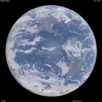
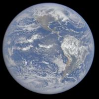
Here is an updated version of a synthesized Earth image using land and 3-D weather data (left) and the correponding DSCOVR image (right). I did tweak the color & intensity a bit on the DSCOVR image.
It's interesting that one can get a handle on what the Earth colors should be by considering that over the ocean, most of the signal is actually light scattered from the sky instead of from the water. We are in essence looking down at the sky (with its attendant Rayleigh scattering) and that is the main reason the Blue Marble is blue. There's also evidence the DSCOVR imagery (as posted on their web site) is contrast stretched since the recent solar eclipse has an oversized region around the umbra where all the details disappear. -------------------- Steve [ my home page and planetary maps page ]
|
||
|
|
|
||
|
Mar 26 2016, 05:55 PM
Post
#105
|
|
|
Senior Member Group: Members Posts: 2079 Joined: 13-February 10 From: Ontario Member No.: 5221 |
Wow, that really does look much more like the Apollo imagery. I did a side-by-side comparison of the blue marble in December, when the views were almost identical, and the differences between the images was clear.
|
|
|
|
|

|
Lo-Fi Version | Time is now: 19th April 2024 - 08:58 PM |
|
RULES AND GUIDELINES Please read the Forum Rules and Guidelines before posting. IMAGE COPYRIGHT |
OPINIONS AND MODERATION Opinions expressed on UnmannedSpaceflight.com are those of the individual posters and do not necessarily reflect the opinions of UnmannedSpaceflight.com or The Planetary Society. The all-volunteer UnmannedSpaceflight.com moderation team is wholly independent of The Planetary Society. The Planetary Society has no influence over decisions made by the UnmannedSpaceflight.com moderators. |
SUPPORT THE FORUM Unmannedspaceflight.com is funded by the Planetary Society. Please consider supporting our work and many other projects by donating to the Society or becoming a member. |
|