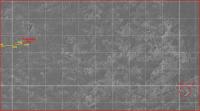
Opportunity Route Map |

  |
Opportunity Route Map |
 Sep 2 2010, 07:45 AM Sep 2 2010, 07:45 AM
Post
#2836
|
|
|
Senior Member  Group: Moderator Posts: 4279 Joined: 19-April 05 From: .br at .es Member No.: 253 |
|
 |
 
|
|
Sep 3 2010, 06:41 AM
Post
#2837
|
|
 Senior Member Group: Admin Posts: 4763 Joined: 15-March 05 From: Glendale, AZ Member No.: 197 |
Chit chat posts moved to the drive discussion topic: From Cambridge Bay to the "parking lot"
Let's try to remember to keep this topic for route map updates. -------------------- If Occam had heard my theory, things would be very different now.
|
|
|
|
|
Sep 3 2010, 07:22 AM
Post
#2838
|
|
|
Senior Member Group: Moderator Posts: 4279 Joined: 19-April 05 From: .br at .es Member No.: 253 |
|
|
|
|
|
Sep 7 2010, 02:50 AM
Post
#2839
|
|
|
Member Group: Members Posts: 202 Joined: 9-September 08 Member No.: 4334 |
Is each grid square 100 x 100 meters?
|
|
|
|
|
Sep 7 2010, 03:33 AM
Post
#2840
|
||
|
Senior Member Group: Moderator Posts: 4279 Joined: 19-April 05 From: .br at .es Member No.: 253 |
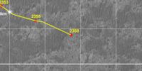
Yup.
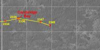
Here's today's map update corresponding to sol 2353.
 Route_Map_Sol2353.kml ( 58.24K )
Number of downloads: 446
Route_Map_Sol2353.kml ( 58.24K )
Number of downloads: 446 |
|
|
|
|
|
|
Sep 9 2010, 07:02 AM
Post
#2841
|
||
|
Senior Member Group: Moderator Posts: 4279 Joined: 19-April 05 From: .br at .es Member No.: 253 |
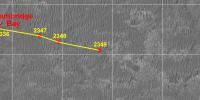
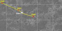
Here's the latest map update, with another km mark just behind: 23km.
Sol 2355.
Route_Map_Sol2356.kml ( 58.8K )
Number of downloads: 357Edit: Updated, because it was off by around 4 meters. It's not a big issue on a single move but this error when accumulated drive after drive may be significant. This post has been edited by Tesheiner: Sep 10 2010, 07:59 AM |
|
|
|
|
|
|
Sep 11 2010, 10:34 AM
Post
#2842
|
||
|
Senior Member Group: Members Posts: 2920 Joined: 14-February 06 From: Very close to the Pyrénées Mountains (France) Member No.: 682 |
I played around with Google Earth as well as Eduardo map from post #2833 and try to find when and where we'll cross the 13kms in strait line from Eagle. You'll find here what I've got.
Anyway there's a problem. Using Google rule, it's easy to calculate distance and as you'll see here, the "probable" 13 km from Eagle circle is close from 2 remarkable lines on Eduardo's grid: the vertical 2 km East and the horizontal 13 km South. Unless Maths are different on Mars, Pythagoras is not going to be happy with that! So, either Google rule is corupted, or Eduardo's grid is wrong or, more probably, I AM wrong. Anyway, I thought I'd better post this either for Eduardo to double check is grid or to know from you if we can trust Google rule. Thanks Note: the probable circle has been set by assuming the route will continue at the same heading (which is close to the "blue" projected official route) as the one from Cambridge to sol 2356 and not shown here since we were not there yet on post #2833 . Note that the distance from Cambridge to this point is (says Google rule) 1 km (1003m to be precise). -------------------- |
|
|
|
|
|
|
Sep 11 2010, 12:07 PM
Post
#2843
|
|
|
Senior Member Group: Moderator Posts: 4279 Joined: 19-April 05 From: .br at .es Member No.: 253 |
What I can say about the grid is that it is based on the fact (?) that the background picture has a resolution of 1m/pix. That picture was taken by HiRISE and is labelled PSP_009141_1780. Note that the original picture taken by the camera has a different resolution (26.9cm/pix), but the "map projected" one has 25cm/pix and my route map uses the latter one at 1/4th size.
An "error" in the map projection process? I don't think so. Perhaps it is related to the fact that the images used on GE have a significant "emission angle" so they are slightly distorted. Perhaps Phil Stooke or Tim Parker could provide some light to this topic. |
|
|
|
|
Sep 11 2010, 12:33 PM
Post
#2844
|
|
|
Member Group: Members Posts: 910 Joined: 4-September 06 From: Boston Member No.: 1102 |
Climber--how great is the discrepancy? Putting a flat grid on a sphere leads to small discrepancies on a small scale and major discrepancies on global scales.
You are correct Tesheiner---"Perhaps Phil Stooke or Tim Parker could provide some light to this topic". -------------------- |
|
|
|
|
Sep 11 2010, 12:54 PM
Post
#2845
|
|
|
Senior Member Group: Members Posts: 2920 Joined: 14-February 06 From: Very close to the Pyrénées Mountains (France) Member No.: 682 |
QUOTE (Floyd @ Sep 11 2010, 02:33 PM)  Climber--how great is the discrepancy? I'd say Pythagorias is easily your friend in this case  Hypothenuse² = horizontal² + vertical² = 169+4=√173 13153m instead of 13000m -------------------- |
|
|
|
|
Sep 11 2010, 04:17 PM
Post
#2846
|
|
|
Solar System Cartographer Group: Members Posts: 10153 Joined: 5-April 05 From: Canada Member No.: 227 |
Don't forget that the map-projected images take into account only an idealized smooth surface - these are not orthophotos corrected for relief distortion. Meridiani Planum is smooth but not perfectly flat, and a discrepancy of a few hundred meters after 13000 m is probably quite reasonable. If you only look at one map-projected image it's easy to think it must have perfect geometry, but try overlaying one image on top of another and you'll find discrepancies at this level.
Phil -------------------- ... because the Solar System ain't gonna map itself.
Also to be found posting similar content on https://mastodon.social/@PhilStooke Maps for download (free PD: https://upload.wikimedia.org/wikipedia/comm...Cartography.pdf NOTE: everything created by me which I post on UMSF is considered to be in the public domain (NOT CC, public domain) |
|
|
|
|
Sep 11 2010, 09:41 PM
Post
#2847
|
|
|
Senior Member Group: Members Posts: 2920 Joined: 14-February 06 From: Very close to the Pyrénées Mountains (France) Member No.: 682 |
I should have said Philthagoras is your friend...
-------------------- |
|
|
|
|
Sep 12 2010, 08:36 AM
Post
#2848
|
|
|
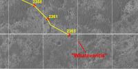
Senior Member Group: Moderator Posts: 4279 Joined: 19-April 05 From: .br at .es Member No.: 253 |
|
|
|
|
|
Sep 17 2010, 03:29 PM
Post
#2849
|
||
|
Senior Member Group: Moderator Posts: 4279 Joined: 19-April 05 From: .br at .es Member No.: 253 |
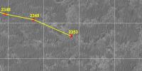
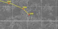
Here's a (late) update related to sol 2361. I was off the town with no way to "work" on due time.
Route_Map_Sol2361.kml ( 59.2K )
Number of downloads: 419 |
|
|
|
|
|
|
Sep 18 2010, 09:17 AM
Post
#2850
|
|
|
Senior Member Group: Moderator Posts: 4279 Joined: 19-April 05 From: .br at .es Member No.: 253 |
|
|
|
|
|

|
Lo-Fi Version | Time is now: 26th April 2024 - 10:31 PM |
|
RULES AND GUIDELINES Please read the Forum Rules and Guidelines before posting. IMAGE COPYRIGHT |
OPINIONS AND MODERATION Opinions expressed on UnmannedSpaceflight.com are those of the individual posters and do not necessarily reflect the opinions of UnmannedSpaceflight.com or The Planetary Society. The all-volunteer UnmannedSpaceflight.com moderation team is wholly independent of The Planetary Society. The Planetary Society has no influence over decisions made by the UnmannedSpaceflight.com moderators. |
SUPPORT THE FORUM Unmannedspaceflight.com is funded by the Planetary Society. Please consider supporting our work and many other projects by donating to the Society or becoming a member. |
|