Titan Dunes, CHARM presentation by Lorenz |

  |
Titan Dunes, CHARM presentation by Lorenz |
 Feb 27 2007, 01:32 AM Feb 27 2007, 01:32 AM
Post
#1
|
|
|
Member  Group: Members Posts: 813 Joined: 29-December 05 From: NE Oh, USA Member No.: 627 |
All...
the latest CHARM presentation details the longitudunal dunes on Titan. http://saturn.jpl.nasa.gov/multimedia/prod...HARM_Lorenz.pdf Slide 4 shows that Titan albedo features are buried in the old Voyager data. Neat. Slides 11 is a great reprojection of DISR. Several slides with great Earth SIR-C and CASSINI Titan dune comparisons. Slide 41 shows a section of T21 with dunes that I do not believe has been released as yet. Slide 42 dune orientations.... Slide 44 showing calculated paths for Titan balloon probes (data taken fron the dune orientations acting as weather vanes). Very cool... Doug.... I was not sure which Titan thread to place this in so I created one. Move it where it makes sense. Craig |
 |
 
|
|
Feb 27 2007, 06:39 PM
Post
#2
|
|
|
Member Group: Members Posts: 117 Joined: 7-December 06 From: Sheffield UK Member No.: 1462 |
Thanks for the link Craig.
That's very interesting stuff. It's fascinating that Voyager 1 did catch a glimpse of Titan's surface markings! -------------------- It's a funny old world - A man's lucky if he gets out of it alive. - W.C. Fields.
|
|
|
|
|
Mar 30 2008, 03:31 PM
Post
#3
|
|||
 Senior Member Group: Moderator Posts: 2785 Joined: 10-November 06 From: Pasadena, CA Member No.: 1345 |
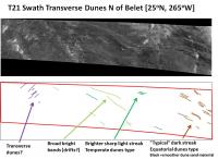
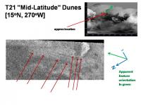
Evidence for tranverse dune (or aeolian deposit) in the T21 RADAR Swath up north of Belet:
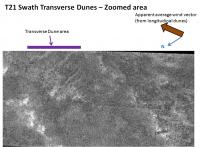
The T21 swath runs from the SW (right in the image) to the NE (left in the image) Moving from the Belet dune fields, the dune direction slowly bends to the NE as seen in the graphic below. To the right of the image (further SW) the normal RADAR dark equatorial linear dunes are observed. Moving northeastward (to the left in the graphic), there are brightish streaks that appear to be aeolian deposits (dunes or drifts of different stuff?). These are also parallel to the equatoirial dunes. Further to the northest (top left in the image), and indicated by purple lines, are a series of similar appearing RADAR-bright streaks that are perpindicular to the other aeolian features. These could be transverse aeolian deposits of material. The second graphic shows a zoom of the area:
I'll speculate that the ridges (brightest areas than run EW - top left to bottom right in the image) in the T19 swath are topographically high enough to funnel the wind direction so that the drift forming wind blows primarily ENE. AFAIK, this is one of the few regions on Titan to show transverse aeolian features. [The others are a few locations in E Belet very close to Adiri in the T8 RADAR; in the T3 RADAR swath there are a few W of Menrva that are suspect ] -Mike -------------------- Some higher resolution images available at my photostream: http://www.flickr.com/photos/31678681@N07/
|
||
|
|
|
||
|
Mar 31 2008, 05:24 PM
Post
#4
|
|
 Member Group: Members Posts: 610 Joined: 23-February 07 From: Occasionally in Columbia, MD Member No.: 1764 |
QUOTE (Juramike @ Mar 30 2008, 11:31 AM)  AFAIK, this is one of the few regions on Titan to show transverse aeolian features. Only if you think they are aeolian features. They just seem like vaguely bright streaks with little to suggest that they are positive relief, nor that they are made of fine-grained material. |
|
|
|
|
Apr 1 2008, 03:54 AM
Post
#5
|
||||||||
|
Senior Member Group: Moderator Posts: 2785 Joined: 10-November 06 From: Pasadena, CA Member No.: 1345 |
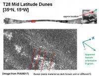
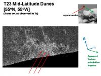
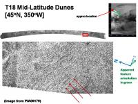
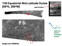
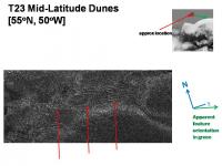
Mid-latitude longitudinal dunes seem different compared to the equatorial dark dunes. They are also rarer.
Here are some examples from the different RADAR swaths. Compared to the dark equatorial dunes, the higher latitude dunes seem finer, and more RADAR-bright.
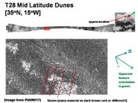
The T28 Swath Mid latitude dunes (first graphic above) is perhaps the best argument that these are Aeolian features, since the parallel dune lines appear to diverge around an obstacle (a bright bump and associated mantle). The T18 Swath has an extensive dune field (consisting of RADAR bright lines) that slowly morphs at the periphery into RADAR-bright material. I would speculate that the T18 dune field is made of RADAR-bright material, the same as in the basin. -Mike -------------------- Some higher resolution images available at my photostream: http://www.flickr.com/photos/31678681@N07/
|
|||||||
|
|
|
|||||||
|
Apr 1 2008, 04:00 AM
Post
#6
|
||
|
Senior Member Group: Moderator Posts: 2785 Joined: 10-November 06 From: Pasadena, CA Member No.: 1345 |
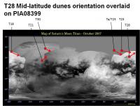
Here is a graphic that shows the orientation of the features in the post above plotted on a global map of Titan. (Compare with slide 42 of the Lorenz CHARM presentation).
Most of these features are also roughly oriented EW. The lowest latitude mid-latitude dune fields seem oriented to the NE (almost same vector as the corresponding northern bright-dark margin in the Equatorial Sand seas). The higher latitude dune fields appear oriented to the ESE. The orientations of the features in the post above seem consistent with the wind vectors inferred from the bright dark margins. -Mike -------------------- Some higher resolution images available at my photostream: http://www.flickr.com/photos/31678681@N07/
|
|
|
|
|
|
|
Apr 1 2008, 04:07 AM
Post
#7
|
||||
|
Senior Member Group: Moderator Posts: 2785 Joined: 10-November 06 From: Pasadena, CA Member No.: 1345 |
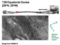
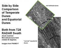
The T28 Swath has two different types of dune fields in relatively close proximity captured in the same swath, with the same look angle, and I suppose about the same resolution.
I rotated the T28 mid-latitude dunes and stuck them against the T28 equatorial dunes for better comparison. The orientation vectors are almost identical (taking into account the bend due to the brightland).
There are approximately 5 dark equatorial dune lines in 10 km across-dune distance. For the mid-latitude bright dunes, there appears to be more dunes in the same amount of space. Is this due to local sand budget? Or a different type of material/construction? -Mike -------------------- Some higher resolution images available at my photostream: http://www.flickr.com/photos/31678681@N07/
|
|||
|
|
|
|||
|
Apr 1 2008, 05:17 AM
Post
#8
|
|||
|
Senior Member Group: Moderator Posts: 2785 Joined: 10-November 06 From: Pasadena, CA Member No.: 1345 |
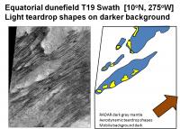
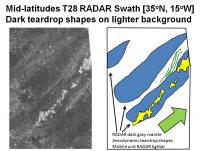
Here is a comparison of the aspect of the "mantle islands" that surround the RADAR brightest terrain. (Presumably the RADAR brightest terrain are the steepest roughest ridges poking up through the surface).
In the Equatorial region, the bright highlands are surrounded by a mantle which is covered by mobile dune sands arriving from the W. This gives an aerodynamic teardrop shape to the mantle. The upwind side is blunt while the downwind side tapers gracefully. In the Equatorial region, the background mobile unit is darker than the mantle. These are the RADAR dark (smooth) dune sands.
In the Mid-latitudes, the bright highlands are surrounded by a mantle which is covered by lighter material arriving from the W. We see the same teardrop aspect to the mantled brightlands. The upwind (usually W) side is blunt while the downwind side (usually E) tapers gracefully. In the Mid-latitudes the mantle is covered by a relatively brightermobile deposit. (A small dunefield can be seen that may have formed from this material). There are many areas that seem to have parallel streaky lighter deposits in several of the polar RADAR swaths. Several of these appear blown against some type of obstacle. [Scan through the T25, T23, Ta, and T28 RADAR Swaths for more examples] So the mid-latitudes apparently have mobile windblown material that is RADAR-bright. This either implies the windblown material is rough on the RADAR-wavelength scale (2 cm) or may be porous and the RADAR-brightness is due to volume scattering. I'll speculate that the lighter mid-latitude deposit is either forming little clumpys that bounce along in the wind (or that clod up after deposition) or it may be very light and fluffy material that forms porous structures that appear RADAR brighter (possibly post-deposition?). Like windblown mid-latitude dust bunnies. -Mike -------------------- Some higher resolution images available at my photostream: http://www.flickr.com/photos/31678681@N07/
|
||
|
|
|
||
|
May 3 2008, 01:46 PM
Post
#9
|
|
|
Senior Member Group: Moderator Posts: 2785 Joined: 10-November 06 From: Pasadena, CA Member No.: 1345 |
Q&A with Jason W. Barnes (VIMS Jason) on Titan dunes: http://saturn.jpl.nasa.gov/news/features/feature20080502.cfm
-------------------- Some higher resolution images available at my photostream: http://www.flickr.com/photos/31678681@N07/
|
|
|
|
|
May 4 2008, 01:30 PM
Post
#10
|
|
|
Member Group: Members Posts: 610 Joined: 23-February 07 From: Occasionally in Columbia, MD Member No.: 1764 |
QUOTE (Juramike @ May 3 2008, 09:46 AM) Q&A with Jason W. Barnes (VIMS Jason) on Titan dunes: http://saturn.jpl.nasa.gov/news/features/feature20080502.cfm Jason and I just got back from this really excellent Planetary Dunes Workshop in Alamogordo. The conference abstracts (LPSC-like in length) are well worth a read. Us Titanophiles were gratified to have a whole session devoted to Titan dunes.... |
|
|
|
|
May 19 2008, 04:58 AM
Post
#11
|
||||
|
Senior Member Group: Moderator Posts: 2785 Joined: 10-November 06 From: Pasadena, CA Member No.: 1345 |
Ewing et al Planetary Dunes Workshop (2008) Abstract 7031. Three-dimensional characterization and morphological dynamics of gypsum sand dunes at White Sands National Monument using airborne LiDAR.
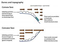
I also found this handy reference on dunes: http://www.nps.gov/archive/whsa/Sand%20Dune%20Geology.htm Ewing et al. correlated the dune shape with the topography left behind by several lakeshores. They found that at the change in slope of each shoreline the dunes have sharper crests, more defects more narrowly shaped crests, and minimal interdune areas. If I understand this correctly, it should be possible to interpret the bottom topography of Titans sand seas by examining at the interdune area.
The graphic above is loosely based on Figure 1 in the Geology reference and is in reference to topographic change in the averaged downwind direction. At wind goes over a steep slope, it drops speed and will lose energy needed to bounce along the saltating particles. The spoil area thus accumulates sand grains. I would assume that funky wind patterns (rotors, turbulence, etc.) would cause a very confusing dune pattern. In addition, it should dump sand everywhere, thus causing a smaller interdune area. As wind is forced up a steep slope, it should increase speed (saltating particles cause friction and cause winds at the interface to be slower mixing it with above interface winds should dramatically speed things up.). Increased speed means more energy to make saltating particles bounce longer, and stronger. This should sweep particles from lower friction-interdune areas. The result should be larger interdune areas.
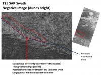
To the W of the Evil Eye feature of W Quivira one can see a partial rim of wider interdune areas. This is a negative image, so dunes are bright and the interdune area is dark. This partial rim could correspond to an area where slopes are increasing (or where sand supply is limited).
Also in the T25 RADAR Swath, the region directly north of Sotra Facula has an interesting dune pattern. This is also a negative image so the dunes are bright and the interdune areas are dark. Here the dunes are initially few and far between in the dark-blue ice sand margin, most likely due to low sand supply. Moving to the E the pattern is nice and regular, then goes chaotic along a boundary running roughly NW-SE. The dune pattern changes away from linear dunes and almost appears as transverse dunes. This change would be consistent with a wind shadow effect (caused by a steep drop at the boundary indicated in blue) removing one of the wind vectors in this area. The dunes get confused and align with a more constant wind coming from the NW (which is also parallel to the putative gradient drop). This is consistent with a broad shelf off the land mass W of Quivira. -Mike -------------------- Some higher resolution images available at my photostream: http://www.flickr.com/photos/31678681@N07/
|
|||
|
|
|
|||
|
May 19 2008, 05:08 AM
Post
#12
|
||
|
Senior Member Group: Moderator Posts: 2785 Joined: 10-November 06 From: Pasadena, CA Member No.: 1345 |
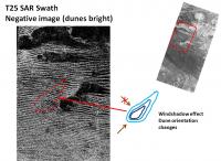
The graphic above shows an area near a RADAR bright area where the dune field is also different than expected. This is in an areas directly S of the W Quivira Evil Eye in the T25 RADAR Swath. The dunes seem to be oriented NW-SE (indicated by the dashed red zone). The dune field is more chaotic and has a smaller intedune area. This would be consistent with an area where the NE component of the wind vector is overexpressed. So it could be an area that is oriented SW-NE and is a downwind depression or drop. (The drop acting as a windshadow for the SE wind vector component). This could be an extension of the bright islands, with an "undermud" third island obsurced by the sands, but evidenced by it's wind shadow effect. (Also note how the most SW bright island in this image seems lower than the bright island to it's NW. It has a lower downwind mantle and the dune lines seem unpreturbed passing over it. This could be a series of three islands slowly getting lower as they drop to the SW, with the most SW lying under the dark smooth muds.) -Mike -------------------- Some higher resolution images available at my photostream: http://www.flickr.com/photos/31678681@N07/
|
|
|
|
|
|
|
Nov 28 2008, 05:10 PM
Post
#13
|
||
|
Senior Member Group: Moderator Posts: 2785 Joined: 10-November 06 From: Pasadena, CA Member No.: 1345 |
Having a running zoo of some of the fun terrain shapes on Titan might be handy:
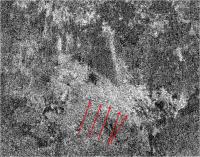
(dog-bone shapes, caudal shapes, chevrons, arrowheads, oval blobs, curly mountains...) For the particular image that Ralph posted (here) in Ta, it's kinda interesting how the RADAR-bright temperate dunes seems to change direction where they intersect the vector of the boundary of the Ta arrowhead-shaped feature. (I indicated a particular long bright-temperate dune with red arrows)
That would seem to imply that the arrowhead shaped feature in this image might be a tableland. -Mike -------------------- Some higher resolution images available at my photostream: http://www.flickr.com/photos/31678681@N07/
|
|
|
|
|
|
|
Nov 28 2008, 11:54 PM
Post
#14
|
|
|
Member Group: Members Posts: 610 Joined: 23-February 07 From: Occasionally in Columbia, MD Member No.: 1764 |
QUOTE (Juramike @ Nov 28 2008, 12:10 PM) .....how the RADAR-bright temperate dunes seems to change direction where they intersect the vector of the boundary of the Ta arrowhead-shaped feature. Dunes ??? Dude, you gotta stop sniffing your test-tubes |
|
|
|
|
Nov 29 2008, 01:31 AM
Post
#15
|
|
|
Senior Member Group: Moderator Posts: 2785 Joined: 10-November 06 From: Pasadena, CA Member No.: 1345 |
Just calling it like I see it. (Titan Dunes thread, post #5)
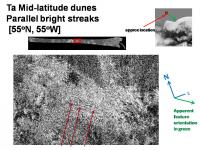
 Nothing says that Titan couldn't have two types of surface materials capable of forming dunes.... [EDIT: I'm going to be a dammit (=adamant) about this: These are RADAR-bright subparallel linear features that seem to flow around topographic obstacles (see T28 swath example) and have a spacing similar to (but 2x less than, again see T28 swath example [here] for a regional comparison) the RADAR-dark equatorial dunes that also seem to be longitudinal to predicted global (and local) wind fields. Unless someone can provide evidence otherwise, I'm gonna continue to call these high-latitude dunes. (which I think are made of organic airfall drifts - no water ice component) Dug back into the Ta radiometry data presented in Pagenelli et al. Icarus 191 (2007) 211-222. doi: 10.1016/j.icarus.2007.04.032. (Figure 2b, and Figure 3). If I found it correctly, the "high-latitude dune region" of Ta has a locally lower brightness temperature (ca. 76-77 deg) than neighboring terrains in Ta (Carolina Blue vs. Hazel). Assuming the same low dielectric constant materials as in the immediately surrounding terrain, that would imply significant volume scattering. (Fluffier stuff). All of this could be consistent with dune-drifts of organic snow.] -------------------- Some higher resolution images available at my photostream: http://www.flickr.com/photos/31678681@N07/
|
|
|
|
|

|
Lo-Fi Version | Time is now: 25th April 2024 - 10:24 PM |
|
RULES AND GUIDELINES Please read the Forum Rules and Guidelines before posting. IMAGE COPYRIGHT |
OPINIONS AND MODERATION Opinions expressed on UnmannedSpaceflight.com are those of the individual posters and do not necessarily reflect the opinions of UnmannedSpaceflight.com or The Planetary Society. The all-volunteer UnmannedSpaceflight.com moderation team is wholly independent of The Planetary Society. The Planetary Society has no influence over decisions made by the UnmannedSpaceflight.com moderators. |
SUPPORT THE FORUM Unmannedspaceflight.com is funded by the Planetary Society. Please consider supporting our work and many other projects by donating to the Society or becoming a member. |
|