March 15, 2010 PDS release |

  |
March 15, 2010 PDS release |
 Apr 2 2010, 09:25 PM Apr 2 2010, 09:25 PM
Post
#76
|
|
|
Member  Group: Members Posts: 890 Joined: 18-November 08 Member No.: 4489 |
QUOTE Are available high resolution dataset of the Apollo11 landing site? no .Besides me and one other and the mit lola team the 23 k lola 64 px/deg is the highest res that is available and that is a low point count inferred map . for the apl 11 site you will need to use stereo pairs and "stereo pipeline" (ALPHA release) in ISIS 3 |
 |
 
|
|
Apr 2 2010, 11:18 PM
Post
#77
|
|
|
Newbie Group: Members Posts: 8 Joined: 23-January 10 Member No.: 5185 |
QUOTE (ValterVB @ Apr 2 2010, 12:11 PM)  I have a question: Are available high resolution dataset of the Apollo11 landing site? Not quite 11, but USGS covered Apollo 15 when working with the Apollo Pan Cam. http://astrogeology.usgs.gov/Projects/webgis/ Someday, I'd like to work with that data set. |
|
|
|
|
Apr 5 2010, 02:44 AM
Post
#78
|
|
|
Solar System Cartographer Group: Members Posts: 10151 Joined: 5-April 05 From: Canada Member No.: 227 |
Joel Raupe just identified the Ranger 9 impact crater in an LROC image:
http://lunarnetworks.blogspot.com/2010/04/ranger-9.html It's clear from a comparison with Ewen Whitaker's identification of the crater in an Apollo 16 image that this is correct. Phil -------------------- ... because the Solar System ain't gonna map itself.
Also to be found posting similar content on https://mastodon.social/@PhilStooke Maps for download (free PD: https://upload.wikimedia.org/wikipedia/comm...Cartography.pdf NOTE: everything created by me which I post on UMSF is considered to be in the public domain (NOT CC, public domain) |
|
|
|
|
Apr 5 2010, 12:17 PM
Post
#79
|
||
|
Solar System Cartographer Group: Members Posts: 10151 Joined: 5-April 05 From: Canada Member No.: 227 |
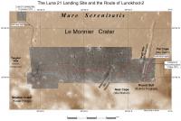
I've been mapping the tracks of Lunokhod 2. The background map is a reduced version of a map I made a while ago, combining Apollo 15 images and the Soviet-era map of the route. Over it I have superimposed LROC images with the actual route shown in red. It's still uncertain in places so there are gaps, especially a large one near the beginning.
The drivers made a route map as they were going, but it was not precise because they did not have precise distance or direction information. An entirely separate issue is how that route should be positioned on the Apollo 15 images. The comparison shows they were often 500 m out, sometimes more. That's pretty good considering the difficulty of this type of work. One interesting observation - they started a bit further north than they thought, drove further south than they expected and ended up further north than they thought. So the total distance driven probably exceeds the 37 km often stated. Phil
-------------------- ... because the Solar System ain't gonna map itself.
Also to be found posting similar content on https://mastodon.social/@PhilStooke Maps for download (free PD: https://upload.wikimedia.org/wikipedia/comm...Cartography.pdf NOTE: everything created by me which I post on UMSF is considered to be in the public domain (NOT CC, public domain) |
|
|
|
|
|
|
Apr 5 2010, 06:21 PM
Post
#80
|
|
|
Junior Member Group: Members Posts: 94 Joined: 15-October 09 Member No.: 4979 |
Nice job!
I think the 37km is correct- it was based on the odometer thing dragging along at the rear of the rover. ADMIN: FULL INLINE QUOTE REMOVED |
|
|
|
|
Apr 5 2010, 07:04 PM
Post
#81
|
|
|
Solar System Cartographer Group: Members Posts: 10151 Joined: 5-April 05 From: Canada Member No.: 227 |
"I think the 37km is correct- it was based on the odometer thing dragging along at the rear of the rover."
Yes, but that doesn't take slippage or gunk in the bearings (or other possible issues) into account. Odometers only give approximate results at the best of times. Phil -------------------- ... because the Solar System ain't gonna map itself.
Also to be found posting similar content on https://mastodon.social/@PhilStooke Maps for download (free PD: https://upload.wikimedia.org/wikipedia/comm...Cartography.pdf NOTE: everything created by me which I post on UMSF is considered to be in the public domain (NOT CC, public domain) |
|
|
|
|
Apr 5 2010, 07:11 PM
Post
#82
|
|
 Senior Member Group: Admin Posts: 4763 Joined: 15-March 05 From: Glendale, AZ Member No.: 197 |
Awesome work, Phil.
-------------------- If Occam had heard my theory, things would be very different now.
|
|
|
|
|
Apr 6 2010, 07:55 PM
Post
#83
|
|
|
Junior Member Group: Members Posts: 23 Joined: 29-November 05 From: france Member No.: 591 |
Superb Phil, and very appreciated,. Thanks |
|
|
|
|
Apr 6 2010, 07:59 PM
Post
#84
|
|
|
Newbie Group: Members Posts: 9 Joined: 17-March 10 Member No.: 5271 |
QUOTE (kenny @ Mar 31 2010, 03:55 AM) Hey! that's a Venusian cloud pattern.... Indeed, I believe that the moon would have a super rotating atmosphere like Venus does due to its slow rotation. |
|
|
|
|
Apr 6 2010, 09:30 PM
Post
#85
|
||
|
Solar System Cartographer Group: Members Posts: 10151 Joined: 5-April 05 From: Canada Member No.: 227 |
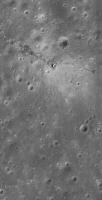
A nice high sun view of Apollo 15.
Phil
-------------------- ... because the Solar System ain't gonna map itself.
Also to be found posting similar content on https://mastodon.social/@PhilStooke Maps for download (free PD: https://upload.wikimedia.org/wikipedia/comm...Cartography.pdf NOTE: everything created by me which I post on UMSF is considered to be in the public domain (NOT CC, public domain) |
|
|
|
|
|
|
Apr 7 2010, 12:05 AM
Post
#86
|
|
|
Senior Member Group: Members Posts: 2998 Joined: 30-October 04 Member No.: 105 |
"Joel Raupe just identified the Ranger 9 impact crater in an LROC image"
Nice impact! Now that we have LROC images of the interior of Alphonsus crater I'm planning to look at the "infamous dark patches" along the rilles on the floor near the rim, as well as the central peak, both of which were areas identified as "Lunar Transient Activity" sites in the 1960's. --Bill -------------------- |
|
|
|
|
Apr 7 2010, 03:40 AM
Post
#87
|
|
|
Member Group: Members Posts: 890 Joined: 18-November 08 Member No.: 4489 |
nice shot Phil
cool find i will be having it here for a few days [attachment=21312:Screenshot_6.jpg] |
|
|
|
|
Apr 7 2010, 11:50 AM
Post
#88
|
||
|
Solar System Cartographer Group: Members Posts: 10151 Joined: 5-April 05 From: Canada Member No.: 227 |
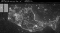
I was looking for Ranger 6 when I chanced upon this - a new version of Ina in Mare Tranquillitatis. As far as I know this has not been seen before.
Phil
-------------------- ... because the Solar System ain't gonna map itself.
Also to be found posting similar content on https://mastodon.social/@PhilStooke Maps for download (free PD: https://upload.wikimedia.org/wikipedia/comm...Cartography.pdf NOTE: everything created by me which I post on UMSF is considered to be in the public domain (NOT CC, public domain) |
|
|
|
|
|
|
Apr 7 2010, 05:37 PM
Post
#89
|
||
|
Senior Member Group: Members Posts: 1074 Joined: 21-September 07 From: Québec, Canada Member No.: 3908 |
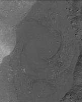
While browsing the LROC images, I found this interesting feature in Giordano Bruno crater: it looks like a frozen swirling pattern in a pool of impact melt.
|
|
|
|
|
|
|
Apr 7 2010, 05:46 PM
Post
#90
|
|
 Administrator Group: Admin Posts: 5172 Joined: 4-August 05 From: Pasadena, CA, USA, Earth Member No.: 454 |
Oh very cool. Which of the LROC images is that from?
-------------------- My website - My Patreon - @elakdawalla on Twitter - Please support unmannedspaceflight.com by donating here.
|
|
|
|
|

|
Lo-Fi Version | Time is now: 26th April 2024 - 03:34 AM |
|
RULES AND GUIDELINES Please read the Forum Rules and Guidelines before posting. IMAGE COPYRIGHT |
OPINIONS AND MODERATION Opinions expressed on UnmannedSpaceflight.com are those of the individual posters and do not necessarily reflect the opinions of UnmannedSpaceflight.com or The Planetary Society. The all-volunteer UnmannedSpaceflight.com moderation team is wholly independent of The Planetary Society. The Planetary Society has no influence over decisions made by the UnmannedSpaceflight.com moderators. |
SUPPORT THE FORUM Unmannedspaceflight.com is funded by the Planetary Society. Please consider supporting our work and many other projects by donating to the Society or becoming a member. |
|