Mission: Hayabusa 2 |

  |
Mission: Hayabusa 2 |
 May 16 2019, 08:35 AM May 16 2019, 08:35 AM
Post
#751
|
|
|
Member  Group: Members Posts: 435 Joined: 14-December 15 Member No.: 7860 |
"...The spacecraft descent has been autonomously aborted at an altitude of about 50m. Hayabusa2 is currently rising to the home position. Telemetry from the spacecraft has been confirmed and the spacecraft is normal, but the target marker has not been dropped...": https://twitter.com/haya2e_jaxa
|
 |
 
|
|
May 16 2019, 11:58 AM
Post
#752
|
|
|
Merciless Robot Group: Admin Posts: 8783 Joined: 8-December 05 From: Los Angeles Member No.: 602 |
That's unfortunate. Wonder if the rough terrain made it difficult for the lidar to provide consistent data.
-------------------- A few will take this knowledge and use this power of a dream realized as a force for change, an impetus for further discovery to make less ancient dreams real.
|
|
|
|
|
May 22 2019, 10:47 AM
Post
#753
|
|
|
Member Group: Members Posts: 817 Joined: 17-April 10 From: Kamakura, Japan Member No.: 5323 |
What follows is from a today's local newspaper.
H2 was meant to descend to 10 m height on 16th to identify suitble landing sites. However, in reality descenht was autonomously aborted at 50 m height and the target marker was not dropped. Close examination showed that H2 thought that it was at 9km height when the sensitivity of the height detector was changed at that time. H2 thought that something was wrong and started rising. On the other hand photos were taken at around 500 m of landing site candidates and they are clear photos. The poject manager thinks that JAXA will go for a landing site candidate very close to craters and drop a target marker. He thinks that there is no delay due to this time's autonomous rising. P |
|
|
|
|
May 22 2019, 11:01 AM
Post
#754
|
|
 Senior Member Group: Members Posts: 2425 Joined: 30-January 13 From: Penang, Malaysia. Member No.: 6853 |
QUOTE (pandaneko @ May 22 2019, 06:47 PM)  What follows is from a today's local newspaper. Many thanks |
|
|
|
|
May 22 2019, 10:51 PM
Post
#755
|
|||
|
Member Group: Members Posts: 435 Joined: 14-December 15 Member No.: 7860 |
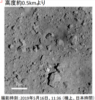
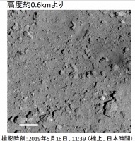
Yesterday (19/5/22) took place JAXA press conference regarding last Hayabusa2 action on May 16 and pdf material from this session was published (in Japanese).
Two pictures of the new crater from 500 and 600 m:
Attached thumbnail(s)
|
||
|
|
|
||
|
May 22 2019, 11:36 PM
Post
#756
|
||
|
Member Group: Members Posts: 435 Joined: 14-December 15 Member No.: 7860 |
My/Google Translate very rough translation of several conclusions from Japanese pdf :
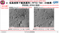
page 7: The reason for the normal abort is that there was a problem with LIDAR distance measurement page 9: About normal abort Event • The spacecraft detected an altitude anomaly in LIDAR, and then moved to the normal abort state by autonomous judgment (The descent ceased and turned upward). - "Normal abort" is a mode triggered in the case of a minor abnormality (eg, some sensor output abnormalities, etc.). ■ The cause of high value abnormality • The reception sensitivity of LIDAR laser light can be adjusted according to the altitude. This time, the reception sensitivity was switched by an automatic sequence when passing 50 m. Noise data at that timing, because of contamination, LIDAR output an abnormal altitude value. – This is the first time that the receiver sensitivity switching has been performed at low altitude. The descent accuracy of "Hayabusa 2" is higher than originally expected. As a result, even when LIDAR laser light hits the target marker, LIDAR was a measure to prevent it. – How noise data is mixed up depends on the environment of Ryugu and the situation of “Hayabusa 2”. It was a case and difficult to predict in advance. ■ Future measures • After this event, we found a switching method that could reliably prevent noise mixing. From the next time on, adopt the formula. page 13: 3. Future operation policy ■ Concept of operation plan from May to July • Currently, Ryugu is approaching the sun (perihelion is September). Since the surface temperature of the asteroid will rise in the future, landing is possible until the beginning of July. • After examining the topography of the crater and the condition of the spacecraft by mid-June, actually from late June to July, we decide whether to implement touchdown operation in season. • Target point: The area where there is an ejector (scattered material) from an artificial crater • Operation name: "Pinpoint Touchdown" (PPTD) • Two or three low altitude descent observation operations will be implemented between May and June before PPTD operation. Landing by it, as well as detailed topographical observation of the candidate site, target markers will be used as a landing gear according to the situation. Dropping: • First time: 5/14 to 5/16 Operation name: PPTD-TM1-The target marker can not be dropped • Second time: 5/28 to 5/30 Operation name: PPTD-TM1A • Third: 6/10 weeks Operation name: PPTD-TM1B (provisional) • Drop a target marker on one of the landing candidate points in PPTD-TM1A operation. The release point is this time. C01 was selected as the best area from among the obtained detailed images.
Attached thumbnail(s)
|
|
|
|
|
|
|
May 22 2019, 11:43 PM
Post
#757
|
|
|
Member Group: Members Posts: 435 Joined: 14-December 15 Member No.: 7860 |
Pandaneko, could you verify this translation from Japanese? (until the official pdf in English appears)
|
|
|
|
|
May 23 2019, 09:57 AM
Post
#758
|
|
|
Member Group: Members Posts: 817 Joined: 17-April 10 From: Kamakura, Japan Member No.: 5323 |
QUOTE (Marcin600 @ May 23 2019, 08:43 AM) Pandaneko, could you verify this translation from Japanese? (until the official pdf in English appears) I am amazed at Google translation accuracy. I confirm that what Google says is more or less true. If I am to add something it is page 9, as follows. About normal abort Event The spacecraft detected an altitude anomaly in LIDAR, and then moved to the normal abort state by autonomous judgment (The descent ceased and turned upward). - "Normal abort" is a mode triggered in the case of a minor abnormality (eg, some sensor output abnormalities, etc.). ■ The cause of high value abnormality The reception sensitivity of LIDAR laser light can be adjusted according to the altitude. This time, the reception sensitivity was switched by an automatic sequence when passing 50 m. Noise data at that timing crept in, because of contamination, LIDAR output showed an abnormally high altitude value. This is the first time that the receiver sensitivity switching has been performed at such a low altitude. Because descent accuracy of "Hayabusa 2" was found to be higher than we originally had expected, we wanted to make sure that even when LIDAR laser light hits the target marker (which has a very high reflectivity), LIDAR does not get it wrong. That was the pirpose of sensitivity changing. How noise data is mixed up depends on the environment of Ryugu and the situation of Hayabusa 2. Noise contamination at that stage was difficult to predict in advance. However, ■ Future measures After this accident, we found a switching method that could reliably prevent this kind of noise mixing. From next time on, H2 will be using the improved formula. P |
|
|
|
|
May 23 2019, 08:30 PM
Post
#759
|
|||
 Senior Member Group: Members Posts: 4246 Joined: 17-January 05 Member No.: 152 |
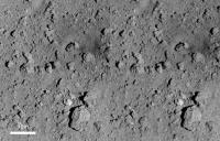
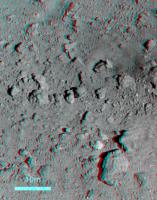
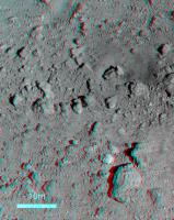
Stereo views of the new crater from the 500/600m images. Cross-eyed:
Anaglyph:
|
||
|
|
|
||
|
May 28 2019, 04:26 PM
Post
#760
|
|
 Administrator Group: Admin Posts: 5172 Joined: 4-August 05 From: Pasadena, CA, USA, Earth Member No.: 454 |
Wow, that is excellent stereo!
-------------------- My website - My Patreon - @elakdawalla on Twitter - Please support unmannedspaceflight.com by donating here.
|
|
|
|
|
May 28 2019, 04:43 PM
Post
#761
|
|
|
Member Group: Members Posts: 140 Joined: 20-November 07 Member No.: 3967 |
QUOTE (elakdawalla @ May 28 2019, 12:26 PM) Wow, that is excellent stereo! Wholeheartedly agree. I often have trouble making these stereo posts "read." Not so with this one! |
|
|
|
|
May 28 2019, 10:35 PM
Post
#762
|
|
|
Member Group: Members Posts: 435 Joined: 14-December 15 Member No.: 7860 |
Official English version of pdf from last press conference has already been published.
And slightly larger versions of new crater pictures from 500 and 600 m are on the Hayabusa2 site. The PPTD-TM1A operation it's just starting. This time the marker is to be dropped very close to the new crater or even inside it! The lowest planned height - 10 m - at 11:23 JST = 2:23 UTC, May 30. If everything goes well we will see even better photos of new crater |
|
|
|
|
May 29 2019, 12:57 PM
Post
#763
|
|
|
Senior Member Group: Members Posts: 1074 Joined: 21-September 07 From: Québec, Canada Member No.: 3908 |
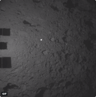
The descent for the PPTD-TM1A operation has begun. A new image is posted about every half-hour here.
|
|
|
|
|
May 29 2019, 02:39 PM
Post
#764
|
|||
|
Senior Member Group: Members Posts: 4246 Joined: 17-January 05 Member No.: 152 |
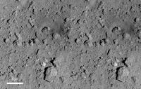
Thanks for the comments! Here are the same stereo views using the high resolution images. Cross-eyed:
Anaglyph:
|
||
|
|
|
||
|
May 30 2019, 11:28 AM
Post
#765
|
|
|
Member Group: Members Posts: 435 Joined: 14-December 15 Member No.: 7860 |
|
|
|
|
|

|
Lo-Fi Version | Time is now: 23rd April 2024 - 10:42 AM |
|
RULES AND GUIDELINES Please read the Forum Rules and Guidelines before posting. IMAGE COPYRIGHT |
OPINIONS AND MODERATION Opinions expressed on UnmannedSpaceflight.com are those of the individual posters and do not necessarily reflect the opinions of UnmannedSpaceflight.com or The Planetary Society. The all-volunteer UnmannedSpaceflight.com moderation team is wholly independent of The Planetary Society. The Planetary Society has no influence over decisions made by the UnmannedSpaceflight.com moderators. |
SUPPORT THE FORUM Unmannedspaceflight.com is funded by the Planetary Society. Please consider supporting our work and many other projects by donating to the Society or becoming a member. |
|