South to Vera Rubin Ridge, (Sites 62-63, Sols 1659-1726, Apr 6 2017-Jun 14 2017) |

  |
South to Vera Rubin Ridge, (Sites 62-63, Sols 1659-1726, Apr 6 2017-Jun 14 2017) |
 Apr 7 2017, 07:24 PM Apr 7 2017, 07:24 PM
Post
#1
|
|
|
Solar System Cartographer  Group: Members Posts: 10229 Joined: 5-April 05 From: Canada Member No.: 227 |
OK, we have left the dunes, and it's time for a new chapter in our story as we head south to Vera Rubin (formerly known as Hematite) Ridge.
Phil -------------------- ... because the Solar System ain't gonna map itself.
Also to be found posting similar content on https://mastodon.social/@PhilStooke Maps for download (free PDF: https://upload.wikimedia.org/wikipedia/comm...Cartography.pdf NOTE: everything created by me which I post on UMSF is considered to be in the public domain (NOT CC, public domain) |
 |
 
|
|
Apr 7 2017, 08:19 PM
Post
#2
|
||
|
Solar System Cartographer Group: Members Posts: 10229 Joined: 5-April 05 From: Canada Member No.: 227 |
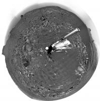
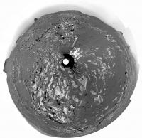
OK, we are on the road, and here is a circular version of Jan's sol 1659 panorama to get us started.
Phil
-------------------- ... because the Solar System ain't gonna map itself.
Also to be found posting similar content on https://mastodon.social/@PhilStooke Maps for download (free PDF: https://upload.wikimedia.org/wikipedia/comm...Cartography.pdf NOTE: everything created by me which I post on UMSF is considered to be in the public domain (NOT CC, public domain) |
|
|
|
|
|
|
Apr 8 2017, 09:39 PM
Post
#3
|
||
 Senior Member Group: Members Posts: 2431 Joined: 30-January 13 From: Penang, Malaysia. Member No.: 6853 |
Mission Update from Ryan Anderson: Sols 1661-1663: DAN has been busy
QUOTE Our drive away from the Ogunquit Beach sand dune location went well, taking us about 35 meters to the southwest and putting us in a good location to continue measuring the composition of the bedrock as we drive up Mt. Sharp. The Sol 1661 plan starts out with a Mastcam mosaic of Old Speck Mountain and some Navcam cloud detection observations. ChemCam will then analyze the targets Blueberry Mountain, Brewer Mountain, and Mud Hole with Mastcam documentation images for each target. I also requested some long distance ChemCam images of a cliff face on Mt. Sharp. I wasnt able to participate in planning today, so we will see if the instructions I left the uplink team were correct! Once the remote sensing is done, MAHLI will take some pictures of the targets Paradise Hill and Treasure Island. APXS will then analyze both targets, with an overnight analysis of Treasure Island. On Sol 1662 we will drive again, followed by an autonomously targeted ChemCam observation, and on sol 1663 Curiosity will have a pretty easy day, with some Mastcam atmospheric dust measurements and a MARDI image of the ground beneath the rover. Throughout this week, the environmental science group has been working to recover the activities that were lost last weekend because of the Deep Space Network outage, such as the morning imaging suite and 15-frame Navcam dust devil movie, while also continuing the normal cadence of monitoring activities. Earlier in the week, a special DAN active measurement was acquired over the sand of Ogunquit Beach. By turning the rover in place and backing up onto the dune, we placed the field of view of DAN's active neutron experiment, which is centered between the rear two wheels, right on the dune sand. DAN active experiments are performed after each rover position change (usually immediately after a drive), but in this case, the measurement was taken just before the rover departed Ogunquit Beach. In a DAN active measurement, neutrons are fired in all directions by the Pulse Neutron Generator, and some neutrons scattered by the soil under the rover return to the DAN detectors. This measurement will allow DAN to compare the amount of hydrogen measured at Namib Dune around sol 1243 to the conditions at Ogunquit Beach.
|
|
|
|
|
|
|
Apr 10 2017, 10:39 AM
Post
#4
|
||
|
Senior Member Group: Members Posts: 2431 Joined: 30-January 13 From: Penang, Malaysia. Member No.: 6853 |
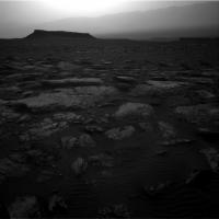
Not much here really (1662 L-NavCam partial) but it's all there is until more frames come down... Midnight Planets reports it as: Curiosity moved approximately 24.1m SSW (-158º) on Sol 1662
|
|
|
|
|
|
|
Apr 10 2017, 07:23 PM
Post
#5
|
||
 Senior Member Group: Members Posts: 4256 Joined: 17-January 05 Member No.: 152 |
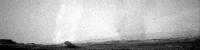
DD activity has been quiet recently, but here's a large (or close) DD on 1660:
It moved right to left (note the negative image). I think it's behind the distant knob, which would make it very big. |
|
|
|
|
|
|
Apr 10 2017, 08:40 PM
Post
#6
|
||
|
Senior Member Group: Members Posts: 2872 Joined: 22-April 05 From: Ridderkerk, Netherlands Member No.: 353 |
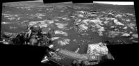
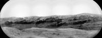
The Navcam L view on Sol 1662.
Jan van Driel
|
|
|
|
|
|
|
Apr 10 2017, 09:15 PM
Post
#7
|
||
|
Solar System Cartographer Group: Members Posts: 10229 Joined: 5-April 05 From: Canada Member No.: 227 |
Thanks, Jan. Here is a circular version. We are creeping through the gap between the dunes.
Phil
-------------------- ... because the Solar System ain't gonna map itself.
Also to be found posting similar content on https://mastodon.social/@PhilStooke Maps for download (free PDF: https://upload.wikimedia.org/wikipedia/comm...Cartography.pdf NOTE: everything created by me which I post on UMSF is considered to be in the public domain (NOT CC, public domain) |
|
|
|
|
|
|
Apr 11 2017, 05:12 AM
Post
#8
|
|
|
Senior Member Group: Members Posts: 2431 Joined: 30-January 13 From: Penang, Malaysia. Member No.: 6853 |
Curiosity Rover Mission Update: Sols 1664-1665: Keep on driving
QUOTE MSL drove about 24 meters on Sol 1662, and another drive is planned for Sol 1664. Before the drive, lots of targeted remote sensing is planned: ChemCam and Right Mastcam will observe a bright rock named "Peaks Island," an exposure of bedding dubbed "Great Wass Island," a sand ripple called "Baldpate Mountain," and an interesting rock that was selected by AEGIS after the Sol 1662 drive, now named "Chebeague Island." Mastcam will also acquire a stereo mosaic of outcrops toward the south, in the direction of the planned drive.
Planning is restricted this week, so two sols were planned today. Untargeted remote sensing planned for Sol 1665 includes passive (no laser) ChemCam sky observations and two ground LIBS targets selected using the AEGIS software. Navcam will then search for dust devils and clouds before the rover rests in preparation for Wednesday's plan. |
|
|
|
|
Apr 12 2017, 03:02 AM
Post
#9
|
||
|
Member Group: Members Posts: 866 Joined: 15-March 05 From: Santa Cruz, CA Member No.: 196 |
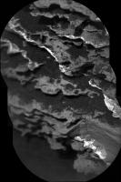
ICe stitch of the sol1661 chemcam. i think that section with the gouge has been chemcammed a month or three ago..?
|
|
|
|
|
|
|
Apr 12 2017, 03:51 AM
Post
#10
|
||
|
Senior Member Group: Members Posts: 2431 Joined: 30-January 13 From: Penang, Malaysia. Member No.: 6853 |
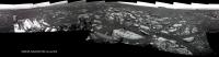
QUOTE (atomoid @ Apr 12 2017, 11:02 AM)  ICe stitch of the sol1661 chemcam. I found the pointing for the RMI's (169.48° to 171.78°), but would like to calculate the approximate height of the cliff face and or the width of the terrain covered by the mosaic. Google Earth (Pro) does not have high res map coverage in that section of the mountain, or I could have used their measuring tool for a rough guide based on the bearing. At that long range AlgorimancerPG would likely be of little use, even if I had the stereo pair to go with the frame below? Does anyone have an idea of the distance to the target? Or has someone already worked out the scale for this mosaic? TIA 
|
|
|
|
|
|
|
Apr 12 2017, 04:34 AM
Post
#11
|
|
 Administrator Group: Admin Posts: 5172 Joined: 4-August 05 From: Pasadena, CA, USA, Earth Member No.: 454 |
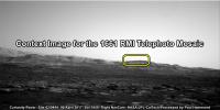
I don't have time to do this myself, but: take the CTX mosaic of the Curiosity landing site, crop it so that Curiosity's current position is at the center, use Photoshop polar > rectangular filter to "unwrap" the horizon, stretch or shrink it vertically as needed to make the horizon legible, and compare it to a Navcam panorama to locate the peaks. (If you don't use PShop I'd be shocked if GIMP didn't have a similar filter.)
-------------------- My website - My Patreon - @elakdawalla on Twitter - Please support unmannedspaceflight.com by donating here.
|
|
|
|
|
Apr 12 2017, 05:39 AM
Post
#12
|
||
|
Senior Member Group: Members Posts: 2431 Joined: 30-January 13 From: Penang, Malaysia. Member No.: 6853 |
QUOTE (elakdawalla @ Apr 12 2017, 12:34 PM) ....CTX mosaic of the Curiosity landing site... Thanks Emily, I look at that process.... Meanwhile Curi has driven as planned, no distance data yet but we have a few end of drive NavCam frames, I will stitch what I can soon. Here is a RMI mosaic acquired before the drive to Site 62/0690 of what I believe to be The 'Exposure of Bedding dubbed 'Great Wass Island' mentioned in the recent USGS update. The pointing is currently shown as above the horizon so I cant accurately locate on the NavCams, nor scale it at the moment, but likely close to the rover.
|
|
|
|
|
|
|
Apr 12 2017, 01:08 PM
Post
#13
|
|
|
Solar System Cartographer Group: Members Posts: 10229 Joined: 5-April 05 From: Canada Member No.: 227 |
If there was any move at all it can only have been a few metres. Maybe stopped prematurely.
Phil -------------------- ... because the Solar System ain't gonna map itself.
Also to be found posting similar content on https://mastodon.social/@PhilStooke Maps for download (free PDF: https://upload.wikimedia.org/wikipedia/comm...Cartography.pdf NOTE: everything created by me which I post on UMSF is considered to be in the public domain (NOT CC, public domain) |
|
|
|
|
Apr 12 2017, 01:39 PM
Post
#14
|
||
|
Senior Member Group: Members Posts: 2431 Joined: 30-January 13 From: Penang, Malaysia. Member No.: 6853 |
QUOTE (Phil Stooke @ Apr 12 2017, 09:08 PM) Maybe stopped prematurely. Agreed, very short indeed, more of a bump... Here is the R-NavCam mosaic in MS ICE using 17 frames, quick and dirty as usual for ICE... Link for full resolution version hosted on IMGUR that may suffice until Jan can work his magic... Much reduced version below, use the link above for the full resolution version
|
|
|
|
|
|
|
Apr 12 2017, 08:14 PM
Post
#15
|
||
|
Senior Member Group: Members Posts: 2872 Joined: 22-April 05 From: Ridderkerk, Netherlands Member No.: 353 |
The Navcam L view on Sol 1664.
Jan van Driel
|
|
|
|
|
|
|

|
Lo-Fi Version | Time is now: 26th September 2024 - 11:10 AM |
|
RULES AND GUIDELINES Please read the Forum Rules and Guidelines before posting. IMAGE COPYRIGHT |
OPINIONS AND MODERATION Opinions expressed on UnmannedSpaceflight.com are those of the individual posters and do not necessarily reflect the opinions of UnmannedSpaceflight.com or The Planetary Society. The all-volunteer UnmannedSpaceflight.com moderation team is wholly independent of The Planetary Society. The Planetary Society has no influence over decisions made by the UnmannedSpaceflight.com moderators. |
SUPPORT THE FORUM Unmannedspaceflight.com is funded by the Planetary Society. Please consider supporting our work and many other projects by donating to the Society or becoming a member. |
|