The western route, 5th leg after stop at Absecon / Reeds Bay |

  |
The western route, 5th leg after stop at Absecon / Reeds Bay |
 Jul 19 2009, 12:47 PM Jul 19 2009, 12:47 PM
Post
#31
|
|
 Member  Group: Members Posts: 578 Joined: 5-November 04 From: Denmark Member No.: 107 |
Some good news in the latest update
 http://marsrovers.nasa.gov/mission/status.html#opportunity QUOTE Opportunity began moving again with a 67-meter (220-foot) drive. The right-front wheel motor current showed some improvement from the actuator resting and extra mobility heating.
The rover performed another long drive on Sol 1946 (July 15, 2009), covering over 70 meters (230 feet). Again, the right front wheel currents showed continued improvement. -------------------- "I want to make as many people as possible feel like they are part of this adventure. We are going to give everybody a sense of what exploring the surface of another world is really like"
- Steven Squyres |
 |
 
|
|
Jul 19 2009, 09:17 PM
Post
#32
|
|
 Special Cookie Group: Members Posts: 2168 Joined: 6-April 05 From: Sintra | Portugal Member No.: 228 |
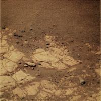
Hey, are these marks left my Oppy's wheels? I don't remember seing this before:
http://qt.exploratorium.edu/mars/opportuni...FFP2514R1M1.JPG -------------------- "Ride, boldly ride," The shade replied, "If you seek for Eldorado!"
Edgar Alan Poe |
|
|
|
|
Jul 19 2009, 11:02 PM
Post
#33
|
|
|
Member Group: Members Posts: 293 Joined: 22-September 08 From: Spain Member No.: 4350 |
She has done that before. The bedrock isn't very rocky.
|
|
|
|
|
Jul 20 2009, 06:35 AM
Post
#34
|
|
|
Senior Member Group: Moderator Posts: 4279 Joined: 19-April 05 From: .br at .es Member No.: 253 |
Check the navcams taken during sol 1950: http://qt.exploratorium.edu/mars/opportuni...cam/2009-07-19/
There are a few mini-craters in sight. The one to the right (NW) was named "Alvin". |
|
|
|
|
Jul 20 2009, 11:48 AM
Post
#35
|
|||
 The Poet Dude Group: Moderator Posts: 5551 Joined: 15-March 04 From: Kendal, Cumbria, UK Member No.: 60 |
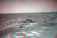
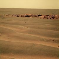
Not sure which crater this is... taken my eye off Oppy during all the LRO drooling, I'll be honest!... but interesting...
And some nice little rocks for Oppy to snuffle around in, too...
-------------------- |
||
|
|
|
||
|
Jul 20 2009, 04:26 PM
Post
#36
|
||
|
Senior Member Group: Moderator Posts: 4279 Joined: 19-April 05 From: .br at .es Member No.: 253 |
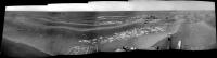
That's Alvin. Here's a navcam mosaic made with those pictures to put it in context.
BTW, has anybody seen Cape St. Mary these last sols? Is it still visible? |
|
|
|
|
|
|
Jul 20 2009, 05:00 PM
Post
#37
|
||
 Senior Member Group: Members Posts: 4246 Joined: 17-January 05 Member No.: 152 |
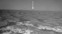
I've been watching Cape St. Mary (Beacon) in the rear view mirror. Our last definite sighting was sol 1942 navcam, though it was getting a bit hard to make out. I've marked it in this crop:
There've been north-pointing navcams since, but I can't make CSM out unambiguously (determining the exact azimuth might help). The lighting is bad (low contrast between sky and ground), but it may be that we're losing it due to topography. We're certainly no farther from CSM than we were at the last sightings. The last good view was sol 1938 pancam: http://marsrovers.jpl.nasa.gov/gallery/all...PGP2286L1M1.JPG edit: this pancam view is so good (at half resolution yet), that given favourable topography we should be able to see CSM for a very long time to come, even from Endeavour (at least from the higher peaks that were visible from Victoria). |
|
|
|
|
|
|
Jul 20 2009, 05:12 PM
Post
#38
|
|
|
Senior Member Group: Moderator Posts: 4279 Joined: 19-April 05 From: .br at .es Member No.: 253 |
There was an "albedo pan" taken during sol 1949 but I don't know if it's already downlinked or not. We should try locating the cape in those pancams; the heading is... (checking in Google Mars) ... 16 degrees CW.
And speaking again about the mini-craters, the one to the left is "Dolphin". |
|
|
|
|
Jul 21 2009, 02:36 PM
Post
#39
|
||
|
The Poet Dude Group: Moderator Posts: 5551 Joined: 15-March 04 From: Kendal, Cumbria, UK Member No.: 60 |
Others will do better, I'm sure. I just fancied having a go
-------------------- |
|
|
|
|
|
|
Jul 21 2009, 02:38 PM
Post
#40
|
||
|
The Poet Dude Group: Moderator Posts: 5551 Joined: 15-March 04 From: Kendal, Cumbria, UK Member No.: 60 |
... and t'other one...
-------------------- |
|
|
|
|
|
|
Jul 22 2009, 01:18 AM
Post
#41
|
|
 Senior Member Group: Members Posts: 3419 Joined: 9-February 04 From: Minneapolis, MN, USA Member No.: 15 |
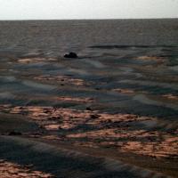
Hmmm... how much of what looks like good flat pavement-stone rock from MRO is actually this kind of pile-up of (relatively recently-emplaced, at least recently enough not to have eroded down to flat yet) jumbled sandstone?
Hopefully, not a lot...  -the other Doug -------------------- The trouble ain't that there is too many fools, but that the lightning ain't distributed right. -Mark Twain
|
|
|
|
|
Jul 22 2009, 03:30 AM
Post
#42
|
|
|
Member Group: Members Posts: 233 Joined: 21-April 05 Member No.: 328 |
Stu, very nice job on the small meteor craters. Can you imagine standing nearby when one of those babies hits?!? Any guess as to the size of the original meteorite? I'm thinking about 8 inches in diameter . . .
|
|
|
|
|
Jul 22 2009, 11:10 AM
Post
#43
|
|
|
Senior Member Group: Moderator Posts: 4279 Joined: 19-April 05 From: .br at .es Member No.: 253 |
I just checked the info from yestersol drive (1952) to find out that Opportunity moved 20m back on her own track.
 Not only that but also the nav/pancam images taken after-drive to plan the next one were pointed back towards the position she were on sol 1947. Perhaps this path was not a safe one? In another topic: the 17km mark was crossed near the end of this drive. |
|
|
|
|
Jul 22 2009, 11:38 AM
Post
#44
|
||
 Senior Member Group: Members Posts: 1887 Joined: 20-November 04 From: Iowa Member No.: 110 |
Going back for closer look at this perhaps?
From sol 1946, these images weren't downloaded until after she had driven on. |
|
|
|
|
|
|
Jul 22 2009, 01:27 PM
Post
#45
|
|
|
Member Group: Members Posts: 362 Joined: 13-April 06 From: Malta Member No.: 741 |
What should we call that!?looks quite big to me?
|
|
|
|
|

|
Lo-Fi Version | Time is now: 23rd April 2024 - 01:40 PM |
|
RULES AND GUIDELINES Please read the Forum Rules and Guidelines before posting. IMAGE COPYRIGHT |
OPINIONS AND MODERATION Opinions expressed on UnmannedSpaceflight.com are those of the individual posters and do not necessarily reflect the opinions of UnmannedSpaceflight.com or The Planetary Society. The all-volunteer UnmannedSpaceflight.com moderation team is wholly independent of The Planetary Society. The Planetary Society has no influence over decisions made by the UnmannedSpaceflight.com moderators. |
SUPPORT THE FORUM Unmannedspaceflight.com is funded by the Planetary Society. Please consider supporting our work and many other projects by donating to the Society or becoming a member. |
|