Distant vistas, Endeavour, Iazu, and beyond |

  |
Distant vistas, Endeavour, Iazu, and beyond |
 May 26 2010, 11:23 AM May 26 2010, 11:23 AM
Post
#436
|
||
 The Poet Dude  Group: Moderator Posts: 5551 Joined: 15-March 04 From: Kendal, Cumbria, UK Member No.: 60 |
Checking on the MER Filenames Decoder (fantastic resource which everyone should have bookmarked, if only to prevent the embarrassment of "spotting" something "new" on an old image, like I've done in the past!: http://www.greuti.ch/oppy/html/filenames_ltst.htm ) that "dusty" image was taken on Tue May 18th. Today's Exploratorium images include shots taken on Sat May 22nd, which show a much clearer view...
-------------------- |
|
 |
 
|
|
|
May 26 2010, 01:24 PM
Post
#437
|
|
 Senior Member Group: Admin Posts: 4763 Joined: 15-March 05 From: Glendale, AZ Member No.: 197 |
Wow that IS clear. I think I can see smectite.
-------------------- If Occam had heard my theory, things would be very different now.
|
|
|
|
|
May 26 2010, 01:40 PM
Post
#438
|
|
|
The Poet Dude Group: Moderator Posts: 5551 Joined: 15-March 04 From: Kendal, Cumbria, UK Member No.: 60 |
 When are we going to get this NASA "high resolution view" then, do you reckon? -------------------- |
|
|
|
|
May 26 2010, 02:36 PM
Post
#439
|
|
 Senior Member Group: Members Posts: 4246 Joined: 17-January 05 Member No.: 152 |
QUOTE (ngunn @ May 26 2010, 09:55 AM)  What I don't know is the transverse baseline length between the two vantage points. From the sols for the two vantage points, you should be able to measure the baseline from Tesheiner's map. |
|
|
|
|
May 26 2010, 02:41 PM
Post
#440
|
|
|
Senior Member Group: Admin Posts: 4763 Joined: 15-March 05 From: Glendale, AZ Member No.: 197 |
QUOTE (Stu @ May 26 2010, 06:40 AM) When are we going to get this NASA "high resolution view" then, do you reckon? Probably after the new employees over at JPL finally get their desks organized and learn where the bathroom is. Then we'll start seeing some really nice image products. -------------------- If Occam had heard my theory, things would be very different now.
|
|
|
|
|
May 26 2010, 03:13 PM
Post
#441
|
|
|
Solar System Cartographer Group: Members Posts: 10146 Joined: 5-April 05 From: Canada Member No.: 227 |
I'm sure Tim Parker will be doing that job, and he already knows where the bathroom is. But he may be tied up with MSL site mapping these days.
Phil -------------------- ... because the Solar System ain't gonna map itself.
Also to be found posting similar content on https://mastodon.social/@PhilStooke NOTE: everything created by me which I post on UMSF is considered to be in the public domain (NOT CC, public domain) |
|
|
|
|
May 26 2010, 03:23 PM
Post
#442
|
|
|
Senior Member Group: Members Posts: 3516 Joined: 4-November 05 From: North Wales Member No.: 542 |
QUOTE (fredk @ May 26 2010, 03:36 PM) you should be able to measure the baseline Yes, since Stu has helpfully provided the missing link in the form of that great filename decoder I'll probably have a go. Is it safe to assume that pancams taken on driving days are taken at the end of the drive? Unfortunately exploratorium seems a bit intermittent - working this morning but not right now. EDIT: Estimating distances and angles from the map I think my calculation with the 50m baseline was about right. This would place the near horizon at 2500m or thereabouts, somewhere near the 1395 contour. That's about 20 m lower than we are now so we're looking down at it at an elevation angle of minus 0.4 degrees. If that's right Santa Maria will not come into view until we've travelled that 2500 m. Hopefully the lip of the Endeavour depression will be visible sooner. |
|
|
|
|
May 26 2010, 04:45 PM
Post
#443
|
|
|
Senior Member Group: Members Posts: 4246 Joined: 17-January 05 Member No.: 152 |
QUOTE (ngunn @ May 26 2010, 04:23 PM) Is it safe to assume that pancams taken on driving days are taken at the end of the drive? Not necessarily. You can be sure by comparing with the local times that the ultimate hazcams were taken - those always follow the drive. You can also compare the site and drive numbers - they'll change after the drive. |
|
|
|
|
May 30 2010, 11:12 AM
Post
#444
|
|
|
The Poet Dude Group: Moderator Posts: 5551 Joined: 15-March 04 From: Kendal, Cumbria, UK Member No.: 60 |
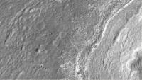
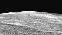
To complement CosmicRocker's gorgeous 3D view, I've stitched together a bunch of 1:1 IAS Viewer zoom views of the region of the Endeavour rim Oppy will be arriving at (I think?)...
http://twitpic.com/1sfwck Fascinating place 
-------------------- |
|
|
|
|
May 30 2010, 11:48 AM
Post
#445
|
||
 Senior Member Group: Members Posts: 2173 Joined: 28-December 04 From: Florida, USA Member No.: 132 |
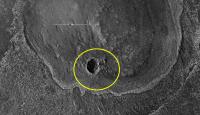
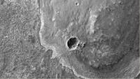
What looks like large chunks of ejecta dug up by the small crater on the south end might make interesting targets.
|
|
|
|
|
|
|
May 30 2010, 12:13 PM
Post
#446
|
|||
|
The Poet Dude Group: Moderator Posts: 5551 Joined: 15-March 04 From: Kendal, Cumbria, UK Member No.: 60 |
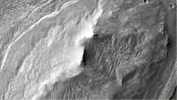
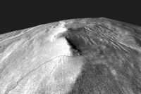
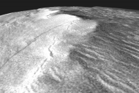
Simulated HiRISE views of what we're all dearly hoping to see eventually... scale as accurate as I can make it...
Oppy approaching the foot of the hills...
And Oppy at the summit of the closest Faraway Hills...
-------------------- |
||
|
|
|
||
|
May 30 2010, 12:26 PM
Post
#447
|
||
|
The Poet Dude Group: Moderator Posts: 5551 Joined: 15-March 04 From: Kendal, Cumbria, UK Member No.: 60 |
QUOTE (centsworth_II @ May 30 2010, 12:48 PM) What looks like large chunks of ejecta dug up by the small crater on the south end might make interesting targets. Those are pretty impressive-sized blocks, too...
-------------------- |
|
|
|
|
|
|
May 30 2010, 08:54 PM
Post
#448
|
||||
|
Member Group: Members Posts: 713 Joined: 30-March 05 Member No.: 223 |
QUOTE (Stu @ May 30 2010, 02:13 PM) Oppy approaching the foot of the hills... cool simulations, Stu ! here are some (very quick&dirty) 3D DEMs made from it:
|
|||
|
|
|
|||
|
May 30 2010, 09:16 PM
Post
#449
|
|
|
The Poet Dude Group: Moderator Posts: 5551 Joined: 15-March 04 From: Kendal, Cumbria, UK Member No.: 60 |
Very nice Nirgal!
Have to be honest, my views aren't so much 'simulations' as 'messing about withs'
-------------------- |
|
|
|
|
May 31 2010, 05:33 AM
Post
#450
|
||
 Senior Member Group: Members Posts: 2228 Joined: 1-December 04 From: Marble Falls, Texas, USA Member No.: 116 |
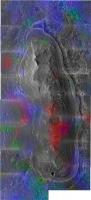
QUOTE (Stu @ May 30 2010, 05:12 AM) ...I've stitched together a bunch of 1:1 IAS Viewer zoom views of the region of the Endeavour rim Oppy will be arriving at... http://twitpic.com/1sfwck Fascinating place That's excellent, Stu. Thanks! That gave me an idea. I've taken your mosaic and have overlaid upon it the CRISM color map from the phyllosilicate paper I posted about earlier. I think it helps to see the CRISM mineralogical anomalies overlain on the high resolution image you provided. In this image ferromagnesian phyllosilicates (smectites) are shades of red and polyhydrated sulfates are shades of cyan.
Correction: I actually lifted the CRISM colors from the image that Emily posted on her blog. Her image was larger than the one in the pdf and it was not annotated. -------------------- ...Tom
I'm not a Space Fan, I'm a Space Exploration Enthusiast. |
|
|
|
|
|
|

|
Lo-Fi Version | Time is now: 18th April 2024 - 08:58 PM |
|
RULES AND GUIDELINES Please read the Forum Rules and Guidelines before posting. IMAGE COPYRIGHT |
OPINIONS AND MODERATION Opinions expressed on UnmannedSpaceflight.com are those of the individual posters and do not necessarily reflect the opinions of UnmannedSpaceflight.com or The Planetary Society. The all-volunteer UnmannedSpaceflight.com moderation team is wholly independent of The Planetary Society. The Planetary Society has no influence over decisions made by the UnmannedSpaceflight.com moderators. |
SUPPORT THE FORUM Unmannedspaceflight.com is funded by the Planetary Society. Please consider supporting our work and many other projects by donating to the Society or becoming a member. |
|