Victoria Annulus, Discusions about Victoria's Apron |

Victoria Annulus, Discusions about Victoria's Apron |
 Aug 9 2006, 01:41 AM Aug 9 2006, 01:41 AM
Post
#1
|
|
|
Senior Member  Group: Members Posts: 1636 Joined: 9-May 05 From: Lima, Peru Member No.: 385 |
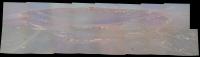
From today, Oppy will start to head toward the Victoria Crater which is about 500 meters away. The drive would take about one month (that is 15 soles of driven with an average of 33 meters/sol, the other 15 soles would be for other purposes or restrictive soles).
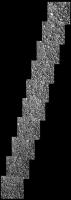
The surface around Victoria Annulus, I seems it won't be as smooth as the way between Eagle and Endurance craters but the surface would have no uniform or parallel wave of sand and dust in small size of ripple. See Phil's Victoria Annulus partial map, Tesheiner's one Victoria Crater picture Otherwise, the surface might have ripples smaller and alike to the ones of El Dorado, on the skirt south side of Columbia Hill. Besides, the Anuulus has no outcrops except to around of few small mini-craters. This is a change of morphology of surface around the Victoria Annulus. What does it explain about this developing kind of surface of sand? Its extension is just around the inside of Victoria's ray of ejection. That is coincidence. Around that has no bigger ripples as the outside of Annulus. The explanation would be that around annulus has smoother rock or outcrop surface, no blocks which had not helped to build ripples by the winds. Other factor, I am not sure, is that the slope from the border of Annulus to crater is positive (going up by few meters), then this might be another factor not to build ripples. I have seen that anywhere in the desert that have a slopes does not have any ripples but only flat surface. Any debate about why the Victoria Annulus does not look like ripples as the outside of Annulus. Rodolfo |
 |
 
|
 |
| Guest_Analyst_* |
Aug 9 2006, 06:46 AM
Post
#2
|
|
Guests |
QUOTE (RNeuhaus @ Aug 9 2006, 01:41 AM)  From today, Oppy will start to head toward the Victoria Crater which is about 500 meters away. I am not sure we are done with Beagle yet. I hope we are not, there is so much to learn, more IDD work etc. No need to rush. Analyst |
|
|
|
|
Aug 9 2006, 07:06 AM
Post
#3
|
|
|
Founder Group: Chairman Posts: 14432 Joined: 8-February 04 Member No.: 1 |
Indeed -there is intended investigation of the things around Beagle before heading off again - RN - you've jumped the fun in a serious way
 Doug |
|
|
|
|
Aug 9 2006, 02:08 PM
Post
#4
|
|
|
Senior Member Group: Members Posts: 1636 Joined: 9-May 05 From: Lima, Peru Member No.: 385 |
QUOTE (djellison @ Aug 9 2006, 02:06 AM) Indeed -there is intended investigation of the things around Beagle before heading off again - RN - you've jumped the fun in a serious way Doug Yes, I forgot that Oppy has to collect more data around Beagle. The earliest date to leave Beagle would be after August 15. Rodolfo |
|
|
|
|
Aug 10 2006, 06:40 AM
Post
#5
|
|
|
Member Group: Members Posts: 713 Joined: 30-March 05 Member No.: 223 |
Re. the Apron/Annulus: Apart from the orbiter images, I wonder how much can be learned from the
recent set of Pancam shots in the potential drive direction so far wrt. to driveability / dune heights, surface material etc. of th Apron area ? |
|
|
|
|
Aug 13 2006, 04:56 PM
Post
#6
|
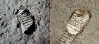
|
|
Junior Member Group: Members Posts: 52 Joined: 24-May 06 Member No.: 784 |
Let's not forget the slightly arcane math question that might be answered by those so inclined:
What's the approximate value in cubic meters of material excavated by the crater, and does it approximately match the Victoria Annulus (the ejecta apron material)? Several assumptions would have to be made about the height profile(s) of ejecta material, and I suppose we'll eventually get to see some interpretations using cross sections at some future date. I'll add a couple more questions I don't necessarily want answered, but did want to idly ask: While I'm assuming the answer would be "Not enough information to tell, but probably, 'NO'", is it possible for a measurable fraction of this evaporitic material to really have been be "vaporized" by the initial impact to the extent that it's missing from the ejecta apron material and the surrounding region? How much got powdered just enough to have been a significant fraction of the dune material outside the annulus that Oppy has been traversing for the last several months? |
|
|
|
|
Aug 13 2006, 08:22 PM
Post
#7
|
|
 Member Group: Members Posts: 656 Joined: 20-April 05 From: League City, Texas Member No.: 285 |
QUOTE (WindyT @ Aug 13 2006, 11:56 AM) Let's not forget the slightly arcane math question that might be answered by those so inclined: What's the approximate value in cubic meters of material excavated by the crater, and does it approximately match the Victoria Annulus (the ejecta apron material)? Several assumptions would have to be made about the height profile(s) of ejecta material, and I suppose we'll eventually get to see some interpretations using cross sections at some future date. We'd need a detailed topographic model of the entire crater and ejecta (or at least a good quadrant of it) before we could answer that question. I'm not confident that we will manage better than a ballpark figure. Sounds like a good student project, though Especially now, we could construct only a very crude model of the interior of the crater.
|
|
|
|
|
Aug 13 2006, 09:33 PM
Post
#8
|
|
 Senior Member Group: Members Posts: 3419 Joined: 9-February 04 From: Minneapolis, MN, USA Member No.: 15 |
It's also very difficult to estimate the amount of material that was exhumed and deposited around Victoria. You would have to have a good topographic map of the contact between the ejecta blanket and its underlying layer. While this *might* be deduced from a seismic study of the neighborhood (the debris usually has more voids and more lower-density inter-boulder fill within its mass than the underlying pre-impact surface, and therefore has a different seismic signature), I don't think you could do much more than a WAG from the photo evidence.
I don't have the relative figures at hand (and it does vary by impact-target composition), but a certain amount of the target, and nearly all of the impactor, are usually vaporized at the moment of impact -- especially for a crater the size of Victoria. That vaporized material is sprayed in tiny droplets around the local area, and on planets with atmospheres, can be spread preferentially on the prevailing winds. * As you reach the edge of the region in which the impactor and some of the target are both vaporized, heat and pressure are high enough to melt the rocks. This melt takes on the geochemical characteristics of *all* of the rock types that exist within the melt region of the impact event. It takes on the physical characteristics of igneous rock. This type of rock is typically called an impact melt. Further out from the center of the blast, the temperatures and pressures decrease through the ranges at which some rock types melt, some are shattered into a fine dust, and others remain resistant to complete destruction. Those pieces which do not melt or shatter become clasts, embedded in a matrix of more easily melted rock. These are fine-clasted breccias -- the clasts in these breccias can be very tiny, indeed. Even farther out, the impact melt and fine-grained breccias generated closer in to the blast are rapidly propelled through a portion of the target that is broken up, but not melted or pulverized. The still-liquid melts from closer in grab up these cooler rock pieces and make large-clast breccias. In many cases, the clasts in these breccias are pretty much pristine and unaltered examples of the rock that was originally swept up by the melt flow. These are the kinds of things we ought to be seeing in Victoria's annulus as we traverse it. However, the fact that the Victoria area may well have had an active water table during or after the emplacement of the debris blanket muddies the waters (pardon the pun). The landscape has undergone massive aeolian erosion since the impact, and has possibly (but not definitively) undergone aqueous alteration since then, too. So the rocks will not necessarily resemble the examples we've seen of impact melts and breccias on Earth and the Moon. * - In re the vaporized material -- it occurs to me that if there was any way to detect the extent of the deposition of vaporized elements from a given impact, we could back-model the atmospheric effects and set some limits on the nature of the atmosphere at the time of the impact. For instance, how thick it was... -the other Doug -------------------- The trouble ain't that there is too many fools, but that the lightning ain't distributed right. -Mark Twain
|
|
|
|
|
Aug 13 2006, 10:08 PM
Post
#9
|
|
|
Senior Member Group: Members Posts: 2998 Joined: 30-October 04 Member No.: 105 |
You are correct, without topo and gridding data/capability, these volumetric estimates will be no more that a very WAG. But let me work up some back-of-the-envelope scribbles: Victoria diameter= 750m, depth=120m, ejecta blanket breadth=600m and ejecta blanket depth at crater rim=10m (or less). These are first guess dimensions of Victoria, we can refine them as we can.
Very good discussion, Doug. The impact will alter the rocks depending on the energies involved. This is one reason why I've pushed to get closer looks at the dark boulders and cobble fields we've seen along the way: these are peeks into the cauldron of the Victoria impact. Gathering this data along the way is critical because once we are on the apron and at Victoria the world changes. --Bill -------------------- |
|
|
|
|
Aug 14 2006, 03:43 AM
Post
#10
|
|
|
Junior Member Group: Members Posts: 52 Joined: 24-May 06 Member No.: 784 |
QUOTE (dvandorn @ Aug 13 2006, 09:33 PM) These are the kinds of things we ought to be seeing in Victoria's annulus as we traverse it. However, the fact that the Victoria area may well have had an active water table during or after the emplacement of the debris blanket muddies the waters (pardon the pun). The landscape has undergone massive aeolian erosion since the impact, and has possibly (but not definitively) undergone aqueous alteration since then, too. So the rocks will not necessarily resemble the examples we've seen of impact melts and breccias on Earth and the Moon. Oh, excellent, thanks! I was a bit afraid to ask about the current speculation on whether there was an active water table when Victoria was formed -- Is this the so-called "Splat!" scenario I've heard referenced to? |
|
|
|
|
Aug 14 2006, 09:08 PM
Post
#11
|
|
|
Senior Member Group: Members Posts: 2998 Joined: 30-October 04 Member No.: 105 |
Here are initial (and very WAG) guesses on the volumes of Voctoria and the ejecta blanket, based on the numbers above:
crater 18x10^6 m^3 ejecta 10x10^6 m^3 or, roughly, the ejecta is half the volume with a rim thickness of 10 meters or therefore roughly an equal volume at 20m thickness. Your guess is as good as mine... --Bill -------------------- |
|
|
|
|
Aug 15 2006, 06:45 AM
Post
#12
|
|
|
Senior Member Group: Members Posts: 3419 Joined: 9-February 04 From: Minneapolis, MN, USA Member No.: 15 |
And, like I said, Bill, the composition of the impact target makes a big difference in how much of the target is vaporized, how much melts, etc. If, for example, the target were mostly jarosite, or there was a thick layer of fairly pure jarosite, it would go from vaporization to pulverization with little melting in between. Some rock types simply don't melt in their primary form -- they pulverize into dust instead. And volatiles content affects the amount of mass vaporized, as well...
However, I rather doubt there was so much jarosite in Victoria's target as to inhibit widespread melting. My understanding is that the jarosite we've found is mostly in the blueberries, and the blueberries do not represent a large percentage of the evaporite down in this terrain. Though, if the blueberries resisted melting and were pulverized into sand and dust instead, that could explain the dark, smooth sandsheet remnants of the annulus. -the other Doug -------------------- The trouble ain't that there is too many fools, but that the lightning ain't distributed right. -Mark Twain
|
|
|
|
|
Aug 16 2006, 06:14 PM
Post
#13
|
|
|
Senior Member Group: Members Posts: 2998 Joined: 30-October 04 Member No.: 105 |
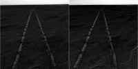
Oppy is currently in the transition zone between the ripples and the apron and has done some IDD work: a series of MI and an MB on the ripple face that she turned on and backed up to on Sol 909.
Visible are the subrounded-to-subangular fine gravel-sized particles, plus angular fragments that look vesicular plus well-rounded granules, some of which might be hematite concretions. And, I may be jumping the gun on this, I think I see discrete sand-sized particles (and not silty clumps). We're statring to see changes in the ripple material. MI Image --Bill -------------------- |
|
|
|
|
Aug 16 2006, 07:50 PM
Post
#14
|
||
|
Founder Group: Chairman Posts: 14432 Joined: 8-February 04 Member No.: 1 |
Wow - nice MI sequence.....trying to merge with Pancam now
(nope - can't match with PC - it's all too samey)
Attached thumbnail(s)
|
|
|
|
|
|
|
Aug 16 2006, 08:06 PM
Post
#15
|
|
|
Senior Member Group: Members Posts: 1636 Joined: 9-May 05 From: Lima, Peru Member No.: 385 |
QUOTE (djellison @ Aug 16 2006, 02:50 PM) Wow - nice MI sequence.....trying to merge with Pancam now (nope - can't match with PC - it's all too samey) Almost full of spherules on the Annulus? They are back again as full since Eagle Crater. Rodolfo |
|
|
|
|
Aug 16 2006, 08:08 PM
Post
#16
|
|
|
Senior Member Group: Moderator Posts: 4279 Joined: 19-April 05 From: .br at .es Member No.: 253 |
QUOTE (djellison @ Aug 16 2006, 09:50 PM) (nope - can't match with PC - it's all too samey) I suppose MMB can help. If not, pointing data on the data tracking web. |
|
|
|
|
Aug 16 2006, 09:09 PM
Post
#17
|
|
|
Founder Group: Chairman Posts: 14432 Joined: 8-February 04 Member No.: 1 |
I don't believe any placement info for the MI is involved in the PCDB
Doug |
|
|
|
|
Aug 16 2006, 09:29 PM
Post
#18
|
|
|
Member Group: Members Posts: 713 Joined: 30-March 05 Member No.: 223 |
QUOTE (djellison @ Aug 16 2006, 09:50 PM) Wow - nice MI sequence.....trying to merge with Pancam now (nope - can't match with PC - it's all too samey) very nice MI stitch, Doug ! couldn't resist doing a quick colorization of this one: 
|
|
|
|
|
Aug 17 2006, 12:01 AM
Post
#19
|
|
|
Senior Member Group: Members Posts: 3419 Joined: 9-February 04 From: Minneapolis, MN, USA Member No.: 15 |
I would be really interested in seeing the mini-TES runs as we have approached the annulus and as we embark onto it. If the annulus is primarily hematitic, we ought to be able to determine that fairly easily with the mini-TES.
What will be very interesting is if the annulus does *not* appear very hematitic to the mini-TES... -the other Doug -------------------- The trouble ain't that there is too many fools, but that the lightning ain't distributed right. -Mark Twain
|
|
|
|
|
Aug 21 2006, 05:44 PM
Post
#20
|
|
|
Senior Member Group: Members Posts: 2998 Joined: 30-October 04 Member No.: 105 |
Fooey. Nothing _on_ the ejecta apron, yet, this is from Sol 912 and is an L257 of the ripple trough we were at a couple of Sols ago... --Bill -------------------- |
|
|
|
|
Aug 21 2006, 08:01 PM
Post
#21
|
|
 Member Group: Members Posts: 133 Joined: 3-June 06 From: the jungle of Nool Member No.: 799 |
4 frames of sol 910 MI pan near Mossbauer press colorized:
|
|
|
|
|
Aug 21 2006, 10:40 PM
Post
#22
|
|
|
Senior Member Group: Members Posts: 2998 Joined: 30-October 04 Member No.: 105 |
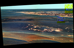
Whew, who said flat as a pancake! Here is an L7 Pancam from today showing aeolian and (possibly) anatolian features. I _think_ I have the location spotted on the MOC image, let me post this and go offline to check.
--Bill -------------------- |
|
|
|
|
Aug 21 2006, 11:05 PM
Post
#23
|
|
|
Founder Group: Chairman Posts: 14432 Joined: 8-February 04 Member No.: 1 |
That's several sols old....
Sol 912 - 10:38am Doug |
|
|
|
|
Aug 21 2006, 11:12 PM
Post
#24
|
|
 Senior Member Group: Moderator Posts: 3431 Joined: 11-August 04 From: USA Member No.: 98 |
QUOTE (Bill Harris @ Aug 21 2006, 10:40 PM) Whew, who said flat as a pancake! Here is an L7 Pancam from today showing aeolian and (possibly) anatolian features. I _think_ I have the location spotted on the MOC image, let me post this and go offline to check. --Bill That's "Espanola" (East Hillock) in the forground, and ol' "Jesse Chisholm" in the background, on Sol 912, I believe. A 'Kodak' moment. 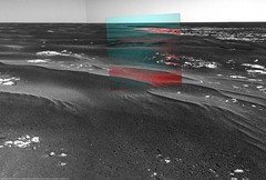
|
|
|
|
|
Aug 21 2006, 11:26 PM
Post
#25
|
|
|
Senior Member Group: Members Posts: 2998 Joined: 30-October 04 Member No.: 105 |
Well, duh. You're correct; I was thinking that these "new images" were further along than they were.
Anticipation, I guess. --Bill -------------------- |
|
|
|
|
Aug 22 2006, 04:23 AM
Post
#26
|
|
 Senior Member Group: Members Posts: 2228 Joined: 1-December 04 From: Marble Falls, Texas, USA Member No.: 116 |
When I saw that sol 912 L7 during my morning MMB update, I nearly jumped out of my seat. I had been waiting for a nice view of the step up to the edge of the apron, and was wondering why we hadn't yet seen a more impressive view of it. At least, that is what I interpret Espanola, and I suppose Jesse Chisolm to be now. Stratigraphically, it looks just like the Halfpipe formation, complete with the overlying layered ripples. The 3D view of it is impressive. As we drove further onto the apron I was seeing all of the dark pebbles between the sparse ripples and wondered why. I was expecting the apron to be totally different. I'll take my geologizing over to the halfpipe topic now.
-------------------- ...Tom
I'm not a Space Fan, I'm a Space Exploration Enthusiast. |
|
|
|
|
Aug 22 2006, 05:04 AM
Post
#27
|
|
|
Senior Member Group: Moderator Posts: 3431 Joined: 11-August 04 From: USA Member No.: 98 |
A quick stitch:
|
|
|
|
|
Aug 24 2006, 01:47 PM
Post
#28
|
|
|
Senior Member Group: Members Posts: 2998 Joined: 30-October 04 Member No.: 105 |
In the lastest Navcam pans, we can see a light-toned area extending to the SE in the direction of Victoria's rim, and this area corresponds to the light-toned area between the windgaps in the crater rim visible on the MOC Route Map image. Close in, we can see that this light-toned material seems to be associated with the transverse ripples caused by the SE wind and we can assume that this light-toned material is likely eroded evaporite material from the rim of Victoria. I'd guess that the prominent dark streaks we see on the ejecta blanket are simply the absense of the light-toned dust. We'll see a a couple of Sols.
jvandriel's Sol 916 Navcam Pan --Bill -------------------- |
|
|
|
|
Aug 25 2006, 01:56 AM
Post
#29
|
|
 Senior Member Group: Moderator Posts: 2262 Joined: 9-February 04 From: Melbourne - Oz Member No.: 16 |
Just been looking at the tracking site for tosol (919) and I see we have this:
CODE 919 p2572.16 4 0 0 4 2 10 pancam_pre_trench_L257R1 Looks like we're going to put a trench in the annulus over the weekend. Does anyone know if Oppy has done any (intentional  ) trenching since the the steering motor failure? I can't remember any. I would imagine that that would affect they way trenching is done compared to what we saw back in the early days. ) trenching since the the steering motor failure? I can't remember any. I would imagine that that would affect they way trenching is done compared to what we saw back in the early days. Should be an interesting weekend. James -------------------- |
|
|
|
|
Aug 25 2006, 06:12 AM
Post
#30
|
|
|
Senior Member Group: Moderator Posts: 4279 Joined: 19-April 05 From: .br at .es Member No.: 253 |
> Does anyone know if Oppy has done any (intentional ) trenching since the the steering motor failure?
I was ready to say "Yes!", but then I saw the "intentional". 
|
|
|
|
|
Aug 25 2006, 12:57 PM
Post
#31
|
|
|
Senior Member Group: Members Posts: 2998 Joined: 30-October 04 Member No.: 105 |
It gets more interesting on the ejecta apron. Looking at Phil Stooke's polar of mhoward's Sol 917 pan we can see a network of polyagonal traces on the surface. These traces are a darker and possibly coarser material evidently outlining paving stones of evaporite. The shape is reminescent of the jumbled and eroded blocks we saw around Endurance crater; they seem too irregular and too large to be the typical "mudcracks" we see on the evaporite surface. And the outlining traces seem to have a light-toned core. Hopefully we'll get a series Pancam closeups of these features and this won't be a drive-by sighting.
So it might be that the lighter tone of this location is not totally due to the windblown evaporite dust as I noted a couple of posts up. Based on what we see here, the sandy ejecta soil is quite thin at this spot, so there may be more to the story. Phil's Sol 917 Polar --Bill -------------------- |
|
|
|
|
Aug 25 2006, 02:31 PM
Post
#32
|
|
|
Senior Member Group: Members Posts: 1636 Joined: 9-May 05 From: Lima, Peru Member No.: 385 |
The surface is so "ironed". Very plane and smooth to ride a surf. The surface has very fine grain covered by small spherules.
Enclosed pictures of Sol 918. http://marsrovers.jpl.nasa.gov/gallery/all...5JP1785R0M1.JPG I think that picture is pointing to South azimuth. http://marsrovers.jpl.nasa.gov/gallery/all...JP1785R0M1.HTML It is evident the surface has the erosion caused by the aeolian force. Probably of North azimuth view. Rodolfo |
|
|
|
|
Aug 25 2006, 11:08 PM
Post
#33
|
|
|
Senior Member Group: Members Posts: 2998 Joined: 30-October 04 Member No.: 105 |
Here is an L257 Pancam of the spot that Oppy trenched on Sol 918 We don't have a color Pancam of the tranch yet, but I've included an L0 Navcam of the trench. The granules look like Blueberries and the sand is well-compacted/indurated or is a very thin layer. Nothing out of the ordinary jumps out at me, but maybe we'll get some MIs of the soil here.
--Bill -------------------- |
|
|
|
|
Aug 26 2006, 12:04 AM
Post
#34
|
|
|
Senior Member Group: Members Posts: 1636 Joined: 9-May 05 From: Lima, Peru Member No.: 385 |
This kind of surface is very easy to drive as off-road. Is indurated and compact as Bill has said. It seems like that the surface has undergone a process of some kind of cementation caused by some kind of chemical reaction.
Do you have any idea about why the surface has got indurated? Rodolfo |
|
|
|
|
Aug 26 2006, 01:40 AM
Post
#35
|
|
|
Senior Member Group: Members Posts: 2998 Joined: 30-October 04 Member No.: 105 |
I'm thinking that one sub-cycle of the Martian hydrologic cycle involves frost formation at night and when the frost is heated in the early morning it already in contact with a sulfate salt and briefly makes a saturated "brine" with a low freezing point which soaks the underlying sand and dust. The water quickly evaporates and the dissolved salts cement the sand. The quantity of water is very very small, but this can happen millions of times, daily, over thousands of years and build up to appreciable thickness. We've seen the duricrust almost universally on Mars.
There may be more to it, but this is the quick explanation of what appears to be happening. --Bill -------------------- |
|
|
|
|
Aug 26 2006, 03:10 AM
Post
#36
|
|
|
Junior Member Group: Members Posts: 77 Joined: 27-June 04 From: Queensland Australia Member No.: 90 |
QUOTE (Bill Harris @ Aug 26 2006, 01:40 AM) I'm thinking that one sub-cycle of the Martian hydrologic cycle involves frost formation at night and when the frost is heated in the early morning it already in contact with a sulfate salt and briefly makes a saturated "brine" with a low freezing point which soaks the underlying sand and dust. The water quickly evaporates and the dissolved salts cement the sand. The quantity of water is very very small, but this can happen millions of times, daily, over thousands of years and build up to appreciable thickness. We've seen the duricrust almost universally on Mars. There may be more to it, but this is the quick explanation of what appears to be happening. --Bill Bill, I may have said this before either here or on another forum, but the Martian regolith contains a high proportion of salts such as magnesium and calcium sulfates and chlorides. These are either anhydrous or monohydrates, such as Kieserite, MgSO4.H2O. My understanding is that the hydration state can change depending on the temperature, and it's a very complex multiphase system. I don't think it can get to the saturated brine stage, simply because there is too much 'dessicant'. I think of Mars in terms of a planet sized vacuum desicator. I've worked with vacuum dessicators in a lab environment, and strange effects can result from phase changes, without involving any free water being produced. These include the production of filament-like crystals among other things. The constant diurnal and season variation over a long timescale can produce such duricrust either without any free water, or at the very least, extremely thin films several molecules thick, due to non equilibrium effects. |
|
|
|
|
Aug 26 2006, 06:02 AM
Post
#37
|
|
|
Senior Member Group: Members Posts: 2228 Joined: 1-December 04 From: Marble Falls, Texas, USA Member No.: 116 |
Well, all I can add to this discussion is that I was hoping we would not yet again see the apparently ubiquitous white stuff. I am not certain that we will really understand it until we dig enough to find and inspect its lower contact. I was hoping for a fresh and deeper roadcut, but apparently this material is quite compacted, and it is difficult to dig through. I discovered a wheel scuff done just prior to the arrival at Beagle. I forgot the sol, but it was only that, a scuff. It found the white stuff just below the surface. Some kind of dessicating salt model might work, but deeper observations are needed.
This is a fascinating planet. Just when you think you have a working model...Wham! -------------------- ...Tom
I'm not a Space Fan, I'm a Space Exploration Enthusiast. |
|
|
|
|
Aug 26 2006, 09:34 AM
Post
#38
|
|
|
Senior Member Group: Members Posts: 2998 Joined: 30-October 04 Member No.: 105 |
Aldebaran, your analysis is correct, I was having trouble expressing that. I believe that the interaction between water and salts is involved but there is not enough water involved to make liquid anything. I live in the humid southeast USA and many of my views are shaped by living in a dripping atmosphere. In my office I have a piece of pyritic sandstone where the pyrite is reacting with water (etc) to make iron sulfate salts (et al), which in turn pull enough water from the air to sustain the pyrite+water+air=nasty stuff reaction.
But this is the eastiest explanation of the duricrust. Tom, I don't think we'll ever NOT see white stuff on Mars and even without seeing the chemistry of it I'd suspect that it is a sulfate salt. Sulfides weather to sulfates and unless you have a lot of water to carry it away the salt tends to accumulate. We've see the light-toned material in the looser drifts every time we've cut a trench to purgatory... Looking at the recent Navcam images I notice that the wheel tracks are light-toned and I suspect that the sand is very thin at this location and we are seeing a reaction zone at the sand-evaporite contact. We need a RAT hole in the wheel scuff. Again, speculation on my part based on a lot of visual cues/clues and minimal data. Still, the truth will prove to be stranger than reality here on Mars... --Bill -------------------- |
|
|
|
|
Aug 26 2006, 02:48 PM
Post
#39
|
||
 Senior Member Group: Admin Posts: 4763 Joined: 15-March 05 From: Glendale, AZ Member No.: 197 |
QUOTE (Bill Harris @ Aug 26 2006, 01:34 AM) I don't think we'll ever NOT see white stuff on Mars I was wondering about that. Are we perhaps looking at sulfates at the tail end of this Viking 1 trench? (Or is it, in the words of Roger Daltry, "Just another trick of the light?") (source: http://photojournal.jpl.nasa.gov/jpeg/PIA00389.jpg)
Attached thumbnail(s)
-------------------- If Occam had heard my theory, things would be very different now.
|
|
|
|
|
|
|
Aug 27 2006, 06:31 AM
Post
#40
|
|
|
Senior Member Group: Members Posts: 2228 Joined: 1-December 04 From: Marble Falls, Texas, USA Member No.: 116 |
QUOTE (RNeuhaus @ Aug 25 2006, 07:04 PM) This kind of surface is very easy to drive as off-road. Is indurated and compact as Bill has said. It seems like that the surface has undergone a process of some kind of cementation caused by some kind of chemical reaction. I think the main reason the surface here is firm and easy to drive on is that the soft, layered ripple material is substantially absent. The underlying material is a good surface to drive on, and I am guessing it is pretty much the same material Opportunity drove on earlier in the trek, before the ripples came to dominate.Do you have any idea about why the surface has got indurated? Rodolfo After looking back at many of the scuffs and trenches Opportunity has made along the way, I am nearly convinced that this white stuff is possibly best explained by some kind of a salt concentration mechanism, as it appears to be a horizon that cross cuts soil stratigraphy but is not continuous. The thing I am finding most interesting lately, is how looking back at old images leads me to new thoughts. It is very different from chasing the latest images for new thoughts. A lot of information has been collected that I had previously glossed over. There is still a lot of low-hanging fruit. -------------------- ...Tom
I'm not a Space Fan, I'm a Space Exploration Enthusiast. |
|
|
|
|
Aug 27 2006, 09:25 AM
Post
#41
|
|
|
Senior Member Group: Members Posts: 2998 Joined: 30-October 04 Member No.: 105 |
This is indeed the beauty of having a continuous organized record of mission imagery: if we see something that is significant, we can look back through the earlier images. For example, the surface here is similar to the material around Endurance but not identical. And why does the rippled (or drifting?) material behave differently?
We sometimes complain about not having access to the "chemistry" data, but that is the "meat" to many a paper and thesis so we'll have to be content with the pictorial side of the dataset. --Bill -------------------- |
|
|
|
|
Aug 31 2006, 03:38 AM
Post
#42
|
|
|
Senior Member Group: Members Posts: 2998 Joined: 30-October 04 Member No.: 105 |
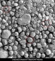
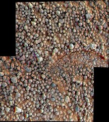
The first MI images of the ejecta apron beyond the rippled transistion zone are coming down to the Exploratorium. One of the early images is amazing-- there is clearly a bimodal distribution of the granule sizes; this speaks volumes about their origin.
More later... --Bill -------------------- |
|
|
|
|
Aug 31 2006, 03:51 AM
Post
#43
|
|
|
Member Group: Members Posts: 233 Joined: 21-April 05 Member No.: 328 |
Bill, one never knows where to post. Re the MI image you have referenced, I would be very interested to know your thoughts on my latest posts in the "Victoria here we come . . ." thread . . .
|
|
|
|
|
Aug 31 2006, 04:50 PM
Post
#44
|
|
|
Member Group: Members Posts: 242 Joined: 17-February 04 From: Ohio, USA Member No.: 34 |
QUOTE (Bill Harris @ Aug 31 2006, 03:38 AM) The first MI images of the ejecta apron beyond the rippled transistion zone are coming down to the Exploratorium. One of the early images is amazing-- there is clearly a bimodal distribution of the granule sizes; this speaks volumes about their origin. More later... --Bill Actually, Bill, I'd argue for at least a trimodal distribution. Don't forget the fines.  Were they deposited after the coarser grains; or do they represent incomplete winnowing of sediments that were deposited all at the same time? |
|
|
|
|
Aug 31 2006, 06:45 PM
Post
#45
|
|
|
Senior Member Group: Members Posts: 2998 Joined: 30-October 04 Member No.: 105 |
Well, maybe, technically, but let's look at the granules and not the sands and the fines. So there.
 The fines may turn out to be another issue. Look at the trend to the larger granules to be pyramidal and not spherical or randomly sub-spherical. My initial thoughts are that these may be ventifacts since they seem to have a similar orientation. I'm thinking that the larger granules are "impact lapilli" or tektites, the basalt basal unit that has been melted, ejected and has formed droplets in free-fall. The smaller granules are hematite concretions, the standby Blueberries. The overlying evaporite unit was pulverized by the impact, thrown out as the ejecta apron where it weathered and eroded quickly, leaving the Blueberries behind. Methinks we'll find a lot of fragmented and residual evaporite under the desert pavement here. My initial theory, but let's see what the Scratchplate shows. And we should be getting more MIs of the wheel trench this evening. --Bill -------------------- |
|
|
|
|
Aug 31 2006, 07:41 PM
Post
#46
|
|
|
Member Group: Members Posts: 242 Joined: 17-February 04 From: Ohio, USA Member No.: 34 |
I agree with your prediction that the evaporite is probably not far below the surface here. But I'm not sure I agree that the "blueberies" would be durable enough to withstand the impact. We've seen examples of fractured 'blueberries" in other areas. An impact might pulverize them along with the evaporite. Could it be that the blueberries are a pre-impact lag deposit that survived the blast? If that's the case; and if the larger granules are tektites, we might expect to see a blueberry or two embedded in the underside of the larger granules. (If we could turn them over).
--lee The larger granules which you suggest are tektites reminded me of taconite pellets, the rounded nodules of milled iron ore that are processed for shipping. I'm not suggesting a similar process for their origin - just an interesting coincidence of form. |
|
|
|
|
Aug 31 2006, 08:49 PM
Post
#47
|
|
|
Member Group: Members Posts: 713 Joined: 30-March 05 Member No.: 223 |
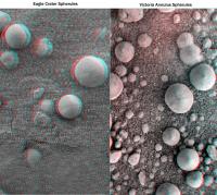
Here is a panorama of the latest MI in false colors showing the bi-modally distributed pebble field:

|
|
|
|
|
Aug 31 2006, 09:04 PM
Post
#48
|
|
 Senior Member Group: Members Posts: 3648 Joined: 1-October 05 From: Croatia Member No.: 523 |
QUOTE (Nirgal @ Aug 31 2006, 09:49 PM) Here is a panorama of the latest MI in false colors showing the bi-modally distributed pebble field: Awesome! Normally, I don't care for colorizations, but one can actually believe the real thing would look like that. Really great work, Nirgal! -------------------- |
|
|
|
|
Sep 1 2006, 01:12 AM
Post
#49
|
|
|
Senior Member Group: Members Posts: 1636 Joined: 9-May 05 From: Lima, Peru Member No.: 385 |
QUOTE (Nirgal @ Aug 31 2006, 03:49 PM) Here is a panorama of the latest MI in false colors showing the bi-modally distributed pebble field: Nice colorization! the image speaks more if it has color! The picture image has called me more curiosity to see all of them. The stone which I suspected most is the ones biggest and with angular edges. However at the top, middle and right of the biggest stone looks like that it has "fossil" marks. Among the spherules, there is five broken spherules (below and left (2) and right (3) from biggest stone). Interesting! Rodolfo |
|
|
|
|
Sep 1 2006, 03:17 AM
Post
#50
|
|
|
Member Group: Members Posts: 477 Joined: 2-March 05 Member No.: 180 |
I find it interesting that so many of them seem to have a little point in the center, and generally facing up.
What else caught my eye: One with a hole in it? |
|
|
|
|
Sep 1 2006, 04:17 AM
Post
#51
|
|
|
Member Group: Members Posts: 233 Joined: 21-April 05 Member No.: 328 |
Fantastic colorization Nirgal!
|
|
|
|
|
Sep 1 2006, 05:40 PM
Post
#52
|
|
 Senior Member Group: Members Posts: 2173 Joined: 28-December 04 From: Florida, USA Member No.: 132 |
Thanks Nirgal, I now have a life-size bit of Mars sitting next to my computer.
|
|
|
|
|
Sep 1 2006, 06:44 PM
Post
#53
|
|
|
Member Group: Members Posts: 242 Joined: 17-February 04 From: Ohio, USA Member No.: 34 |
Very impressive Nirgal. What caught my eye was, just up from the lower left corner, is one of the larger grains with a smaller grain that appears to be embedded in it.
---lee |
|
|
|
|
Sep 1 2006, 06:51 PM
Post
#54
|
|
|
Member Group: Members Posts: 688 Joined: 20-April 05 From: Sweden Member No.: 273 |
QUOTE (Jeff7 @ Sep 1 2006, 05:17 AM) I find it interesting that so many of them seem to have a little point in the center, and generally facing up. I noticed the same thing. They look like *very* small ventifacts. If so they must have been sitting there for a loooong time. tty |
|
|
|
|
Sep 1 2006, 07:35 PM
Post
#55
|
|
|
Newbie Group: Members Posts: 5 Joined: 30-November 05 Member No.: 593 |
QUOTE (Jeff7 @ Aug 31 2006, 11:17 PM) I find it interesting that so many of them seem to have a little point in the center, and generally facing up. What else caught my eye: One with a hole in it? I see 3 with holes in them - so it can't be a camera artifact. Did someone break their necklace here?
|
|
|
|
|
Sep 2 2006, 06:04 AM
Post
#56
|
|
|
Member Group: Members Posts: 109 Joined: 9-April 04 Member No.: 66 |
Um, where are we?
http://qt.exploratorium.edu/mars/opportuni...ZTP2560R3M1.JPG I thought we were a long ways from anything but, small dunes. |
|
|
|
|
Sep 2 2006, 06:16 AM
Post
#57
|
|
|
Newbie Group: Members Posts: 10 Joined: 20-April 05 Member No.: 293 |
QUOTE (gregp1962 @ Sep 1 2006, 11:04 PM) Um, where are we? http://qt.exploratorium.edu/mars/opportuni...ZTP2560R3M1.JPG I thought we were a long ways from anything but, small dunes. That's from almost a month ago. |
|
|
|
|
Sep 2 2006, 08:08 AM
Post
#58
|
|
|
Member Group: Members Posts: 295 Joined: 2-March 04 From: Central California Member No.: 45 |
Greg, that image, for me, was immediately recognizable as the far wall of beagle from the approach...I'd know that big slab anywhere
-------------------- Eric P / MizarKey
|
|
|
|
|
Sep 2 2006, 05:50 PM
Post
#59
|
||
|
Newbie Group: Members Posts: 5 Joined: 6-July 06 From: Sacramento, CA Member No.: 958 |
QUOTE (BEHSTeacher @ Sep 1 2006, 12:35 PM) I see 3 with holes in them - so it can't be a camera artifact. Did someone break their necklace here? We need a geologist to explain what the deal is with these "holy"rocks. What could be causing such perfect little holes? When I noticed just the one at the upper left, I assumed it was a camera artifact. I have to assume that we are looking at something that disolved out of the rock, or was created when the rock formed. Any ideas? -
|
|
|
|
|
|
|
Sep 2 2006, 06:16 PM
Post
#60
|
|
|
Senior Member Group: Members Posts: 1636 Joined: 9-May 05 From: Lima, Peru Member No.: 385 |
The microcospic picture taken on scrapped track. It has no spherules but only fine grain -powder- and it is somewhat endurated.
http://marsrover.nasa.gov/gallery/all/1/m/...8ZP2936M2M1.JPG Rodolfo |
|
|
|
|
Sep 2 2006, 09:09 PM
Post
#61
|
|
|
Member Group: Members Posts: 656 Joined: 20-April 05 From: League City, Texas Member No.: 285 |
QUOTE (RNeuhaus @ Sep 2 2006, 01:16 PM) The microcospic picture taken on scrapped track. It has no spherules but only fine grain -powder- and it is somewhat endurated. I see 2-3 ratted blueberries, plus 3 distinct horizontal layers. Looks like ratted evaporite to me. |
|
|
|
|
Sep 2 2006, 09:15 PM
Post
#62
|
|
|
Founder Group: Chairman Posts: 14432 Joined: 8-February 04 Member No.: 1 |
It's soil pushed flat by the mossbauer.
Doug |
|
|
|
|
Sep 3 2006, 04:26 PM
Post
#63
|
||
|
Member Group: Members Posts: 233 Joined: 21-April 05 Member No.: 328 |
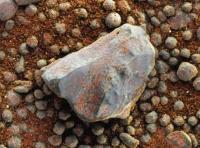
I hate to keep obsessing about this bit of conchoidally fractured pebble, but Nirgal's superb colorization adds to its interest. A fractured face is visible, while we can just make out the margins of the downward face -- and this would seem to indicate a patina typical of the alluvial (!) chert gravels found in abundance in, among many other places, my home state of Louisiana. So one thesis is that, among the layers disturbed by the impact which created Victoria, is bed of alluvial gravel !?! There are of course other weathering processes which can create patinas, but it is interesting to note the relative freshness of the fractured surface.
|
|
|
|
|
|
|
Sep 4 2006, 04:59 PM
Post
#64
|
|
|
Senior Member Group: Members Posts: 1636 Joined: 9-May 05 From: Lima, Peru Member No.: 385 |
Gleenwsmith: The stone is the original comparing to the rest. It has good edges, a fractured stone after so many years, between thousand millions and millions years. Very strong stone which has withstanded the aeolian and hydro erosion . About the chemical erosion not like to the spherules which is the product of the chemical process
 ? ? I have enclosed a picture. The surface has a very fine grain that leaves the wheels neatly well marked. http://marsrovers.jpl.nasa.gov/gallery/all...8ZP2575L5M1.JPG Rodolfo |
|
|
|
|
Sep 5 2006, 03:49 AM
Post
#65
|
|
|
Member Group: Members Posts: 233 Joined: 21-April 05 Member No.: 328 |
Rodolfo, I am certainly agreeing with you if you are saying that the fractured stone is the result of different processes than those which resulted in the spherules. And nice picture indicating how spherules are sitting on top of a duricrust. . .
|
|
|
|
|
Sep 5 2006, 06:28 AM
Post
#66
|
|
|
Senior Member Group: Members Posts: 3419 Joined: 9-February 04 From: Minneapolis, MN, USA Member No.: 15 |
I keep wondering if the specific forms we see in the soil right now (the granule size ranges, the organization of the granules into three basic sizes and shapes, color and hardness) can tell us something about the conditions of the impact target at the time of the impact.
Does any of the soil material suggest that the impact target was wet or otherwised volatile-enriched? I'm assuming that at least some of the granules we see are pieces of impact melt, and I suspect the conical "drops" that some have labeled tecktitic are the most likely candidate for being impact melts. Does their shape and size, and the nearly ubiquitous hole in the center, suggest anything about volatiles content of the target? Or about its composition? Do we have to assume that their present shape and distribution is the result of erosional processes, or is there anything of their formation still evident in what we can see? Unfortunately, the three granule types seem so thoroughly mixed that it will be impossible for Oppy to get a good specific composition of just one of the types...  so we'll have to infer composition of the various types from the aggregate Mossbauer and APXS readings we get from it. But I think that, if we could answer some questions about the constituents of this soil, we'd have some further insight into the chemical and climatic history of the region. so we'll have to infer composition of the various types from the aggregate Mossbauer and APXS readings we get from it. But I think that, if we could answer some questions about the constituents of this soil, we'd have some further insight into the chemical and climatic history of the region.-the other Doug -------------------- The trouble ain't that there is too many fools, but that the lightning ain't distributed right. -Mark Twain
|
|
|
|
|
Sep 9 2006, 10:19 AM
Post
#67
|
|
|
Senior Member Group: Members Posts: 2998 Joined: 30-October 04 Member No.: 105 |
Finally, we got the makin's for L257 images of the current trench and skuff on the ejecta apron.
Doug, I haven't decided about volatiles in the impact target. We'll need to look into Emma Dean and specifically the evaporite chunks with the unusual texture and/or darker tone. Maybe we won't do a drive-by this time... --Bill -------------------- |
|
|
|
|
Sep 10 2006, 02:59 AM
Post
#68
|
||
 Member Group: Members Posts: 700 Joined: 3-December 04 From: Boulder, Colorado, USA Member No.: 117 |
I couldn't resist this comparison:
|
|
|
|
|
|
|
Sep 10 2006, 03:04 AM
Post
#69
|
|
|
Member Group: Members Posts: 233 Joined: 21-April 05 Member No.: 328 |
john s -- sweet!
|
|
|
|
|
Sep 10 2006, 03:41 AM
Post
#70
|
|
|
Senior Member Group: Members Posts: 2228 Joined: 1-December 04 From: Marble Falls, Texas, USA Member No.: 116 |
That was freakin' brilliant!
It is now my wallpaper. It makes me realize that before long we will have bootprints on Mars.
-------------------- ...Tom
I'm not a Space Fan, I'm a Space Exploration Enthusiast. |
|
|
|
|
Sep 10 2006, 03:49 AM
Post
#71
|
||
|
Junior Member Group: Members Posts: 77 Joined: 27-June 04 From: Queensland Australia Member No.: 90 |
QUOTE (SacramentoBob @ Sep 2 2006, 05:50 PM) We need a geologist to explain what the deal is with these "holy"rocks. What could be causing such perfect little holes? When I noticed just the one at the upper left, I assumed it was a camera artifact. I have to assume that we are looking at something that disolved out of the rock, or was created when the rock formed. Any ideas? -
I'm not a geologist, but I minored in geology. Others have reported these holes. The best explanation I can find is that the concretions in many cases are associated with a network of dedos-like stalks. When the concretions are worn out of the rock, there is a tendency for these to snap off at the concretion, leaving a small indentation. We have noted the presence of these 'stalks' in several other locations, for example at the feature known as 'Pilbara' by Fram crater on the approach to Endurance. While wind erosion and chemical erosion certainly played a part in producing the stalks, there may be some evidence for a partial network of weakly indurated material within the matrix. This MI image shows an example of such a stalk protruding from a spherule. http://marsrovers.jpl.nasa.gov/gallery/all...00P2959M2M1.JPG Please view the above as a half-baked suggestion rather than a fully baked hypothesis I'm just thinking aloud. Bill Harris, I like your explanation of 'tektites' for at least some of the pebble-like fragments we have seen amongst the desert pavement. I'm not sure if that's a cut and dried explanation without more data, but it stands to reason that there must be 'tektites' present on Mars somewhere. |
|
|
|
|
|
|
Sep 10 2006, 06:31 AM
Post
#72
|
|
|
Senior Member Group: Members Posts: 2228 Joined: 1-December 04 From: Marble Falls, Texas, USA Member No.: 116 |
I've gone over all of the recent MIs and I can't find anything I'd call a tektite. If someone would post a picture identifying one of the suspected critters, I'd appreciate it.
Regarding that berry with the central hole, it's not the first one we've seen on this long trek. That one seems to be one of the occasional concretions that we've come across that has been cleaved in half and abraded. I would interpret the hole as the place where the concretion's center was more friable, so the material was easily eroded away. That is not an uncommon phenomenon in earthbound concretions. The one with the dimple might be the same thing as the first. The third hole identified is in a clast (fragment) that doesn't resemble a concretion at all. There seems to be several sub-populations of fragments of different origins on the surface here. Among those that are not obviously concretions, some have noticeable porosity. But I must admit that the MI posted by SacramentoBob showing three different, tiny clasts with neat round holes is intriguing. ...just thinking out loud here... I wish I could tie them all together with a pretty pretty pink ribbon, but I can't. -------------------- ...Tom
I'm not a Space Fan, I'm a Space Exploration Enthusiast. |
|
|
|
|
Sep 10 2006, 06:54 AM
Post
#73
|
|
|
Junior Member Group: Members Posts: 77 Joined: 27-June 04 From: Queensland Australia Member No.: 90 |
QUOTE (CosmicRocker @ Sep 10 2006, 06:31 AM) Regarding that berry with the central hole, it's not the first one we've seen on this long trek. That one seems to be one of the occasional concretions that we've come across that has been cleaved in half and abraded. I would interpret the hole as the place where the concretion's center was more friable, so the material was easily eroded away. That is not an uncommon phenomenon in earthbound concretions. The one with the dimple might be the same thing as the first. I've also noticed a disproportionate number of concretions that have split in half. If we accept that the concretions formed within the evaporite matrix as per the terrestrial analogy, I'd expect to find fine planar inclusions of evaporite within the concretion itself. We've discussed the possibility of changes in hydration states with diurnal temperature fluctuations. Intuitively, any such inclusions would tend to undergo a net increase in volume with an increase in hydration state and this would act as a wedge, exerting internal pressure on the 'berry' causing it to split in the plane of the original strata. Do you think that's a credible mechanism? |
|
|
|
|
Sep 10 2006, 11:49 AM
Post
#74
|
|
|
Senior Member Group: Members Posts: 2998 Joined: 30-October 04 Member No.: 105 |
"Tektites" or "impact lapilli" are the best name I can come up with. Unlike earthly tekties they are neither appear glassy nor aerodynamic (for the most part) and unlike earthly lapilli they are't volcanic. They are the basaltic basal unit melted by the impact, assuming a near-spherical shape in the thin atmosphere and falling onto the ejecta blanket. I think the observation of the larger-sized spherules in this locale is important. Look at the L257's taken at this stop, the larger spherules tend to have a color similar to the basaltic cobbles, while the smaller spherules have a slightly different color. I see we have new Pancams of this crater and the distinctive light-toned rocks, so perhaps this will not be a drive-by sighting. Although we'd like to get to the photo-ops at Victoria, we need to do some science at this stop. Understanding erosional-depositional processes on Mars is the key to understanding the geomorph.
I agree with the idea that the holes in the berries are related to the stalks we've seen. And I wonder if some of the berries are not hollow or have a "softer" internal composition (related to Aldebaran's "planar inclusions"). I'm thinking that we see more broken berries here because of the impact. When the evaporite was catastrophically fractured and pulverized by the impact some of the berries were broken along the fracture lines, whereas with slower weathering processes the evaporite matrix breaks around the berries. By way of earthly analogy, take a look at the attached... --Bill -------------------- |
|
|
|
|
Sep 10 2006, 01:16 PM
Post
#75
|
|
|
Senior Member Group: Members Posts: 2998 Joined: 30-October 04 Member No.: 105 |
Here are the latest color Pancams from the current stop, maybe these are next targets. Interesting rocks, we'll discuss later. I need to go fly...
--Bill -------------------- |
|
|
|
|
Sep 11 2006, 01:45 AM
Post
#76
|
|
|
Senior Member Group: Members Posts: 3419 Joined: 9-February 04 From: Minneapolis, MN, USA Member No.: 15 |
QUOTE (CosmicRocker @ Sep 10 2006, 01:31 AM) I've gone over all of the recent MIs and I can't find anything I'd call a tektite. If someone would post a picture identifying one of the suspected critters, I'd appreciate it. I don't know if I'd call them tektites, exactly, but I think the larger rounded bodies in these soils, which tend to have randrop or conical shapes, might well be droplets of impact melt. That would make them similar to tektites in origin and general configuration. But tektites are often formed in the initial blast, from materials near the surface, and are blown a considerable distance away from the impact site. These droplets, if they're impact melt, came from less than 200 meters away. So they were formed later in the impact process (and hence probably contain materials from deeper within the excavation), and were ejected far less energetically than the more far-flung ejecta. -the other Doug -------------------- The trouble ain't that there is too many fools, but that the lightning ain't distributed right. -Mark Twain
|
|
|
|
|
Sep 11 2006, 04:36 AM
Post
#77
|
|
|
Senior Member Group: Members Posts: 2228 Joined: 1-December 04 From: Marble Falls, Texas, USA Member No.: 116 |
Doug: I don't have a problem with the term tektite. I've always assumed that any impact melt droplet that solidified into a glassy sphere or aerodynamically altered shape was essentially a tektite. I see a lot of spheres and a fair number of multiple sphere agglomerations, but I don't see anything that looks glassy, nor anything that looks aerodynamic. I can discount the importance of the things being glassy by assuming they have had time to devitrify or be recrystalized by some later alteration process, but I really don't see anything that can't be more simply explained by assuming that these spheres are simply the same concretions we have been seeing since day 1.
I think I have seen a very few that could be roughly described as conical, but those looked more like multiply-connected berries that were broken or eroded, or berries that were broken from eroded stalks of the evaporite cemented sandstone, like those we saw at Fram. I'd love to see something new, like evidence of an impact melt, but I am not convinced, yet. -------------------- ...Tom
I'm not a Space Fan, I'm a Space Exploration Enthusiast. |
|
|
|
|
Sep 11 2006, 06:00 AM
Post
#78
|
|
|
Senior Member Group: Members Posts: 2228 Joined: 1-December 04 From: Marble Falls, Texas, USA Member No.: 116 |
QUOTE (Bill Harris @ Sep 10 2006, 06:49 AM) "Tektites" or "impact lapilli" are the best name I can come up with. Unlike earthly tekties they are neither appear glassy nor aerodynamic (for the most part) and unlike earthly lapilli they are't volcanic. They are the basaltic basal unit melted by the impact, assuming a near-spherical shape in the thin atmosphere and falling onto the ejecta blanket. I think the observation of the larger-sized spherules in this locale is important. Look at the L257's taken at this stop, the larger spherules tend to have a color similar to the basaltic cobbles, while the smaller spherules have a slightly different color. I see we have new Pancams of this crater and the distinctive light-toned rocks, so perhaps this will not be a drive-by sighting. Although we'd like to get to the photo-ops at Victoria, we need to do some science at this stop. Understanding erosional-depositional processes on Mars is the key to understanding the geomorph. I've looked at the L257s, but I really wish someone would post an image with an arrow or two. Damn, I see you have pre-emptivley eliminated two of the previous arguments made in my reply to Doug. Ok. I don't like using terms like "impact lapilli," since it seems to remove the historical connection between lapilli and volcanic processes. Also, these spherules have always appeared to have essentially no internal structure, as opposed to lapilli, which often display concentric rings of ash agglomeration internally.I agree with the idea that the holes in the berries are related to the stalks we've seen. And I wonder if some of the berries are not hollow or have a "softer" internal composition (related to Aldebaran's "planar inclusions"). I'm thinking that we see more broken berries here because of the impact. When the evaporite was catastrophically fractured and pulverized by the impact some of the berries were broken along the fracture lines, whereas with slower weathering processes the evaporite matrix breaks around the berries. By way of earthly analogy, take a look at the attached... --Bill Correct me if I am wrong, but the last thing we heard from SS regarding the cobbles was this August 2005 quote: "Oh, yeah, and the cobble we looked at with Opportunity isn't a meteorite, it's a martian rock... and one that's very different from anything we've ever seen before. Busy times... " I've been wondering about the "basal basaltic unit" too. In this part of Meridiani we are supposed to be sitting on top of several hundred meters of "light colored sediment." Victoria surely didn't excavate basalt, unless there is a surprise inside, or unless the impactor was a secondary of external origin. -------------------- ...Tom
I'm not a Space Fan, I'm a Space Exploration Enthusiast. |
|
|
|
|
Sep 11 2006, 10:34 AM
Post
#79
|
|
|
Senior Member Group: Members Posts: 2998 Joined: 30-October 04 Member No.: 105 |
OK, then explain what we're seeing on the ejecta blanket. There have been several substantial or suble differences in the surface compared to the Meridiani plains. Your shot.
The "dark basaltic basal unit" is the holy grail tying the "oh yeah" cobbles to anything. It may not exist, but OTOH, since we have seen only a few meters of several hundred meters of "light colored sediment", we can't say that it doesn't. Your shot at the explanation... --Bill -------------------- |
|
|
|
|
Sep 11 2006, 02:00 PM
Post
#80
|
|
|
Member Group: Members Posts: 242 Joined: 17-February 04 From: Ohio, USA Member No.: 34 |
I think Bill might be on the right track. Look again at Nirgal's colorized image of the pebbles:
http://mitglied.lycos.de/user73289/misc/op...24pan_col_d.jpg Many of the larger grains have a shape that looks like a Hershey's kiss. Some have suggested that they might be ventifacts. But it would take winds blowing equally from every direction to sculpt a grain that way. Unlikely IMO. Bill's suggestion that they may be formed by a melt/impact process makes more sense to me at this point. One of the grains at the lower left-hand edge of Nirgal's image provides some tantalizing evidence for this idea. The grain is cut by the edge of the image, but you can see that there is a smaller grain (blueberry) contained it a larger grain. It looks as if part of the larger grain has wrapped around the smaller grain. I'm envisioning a process like this: the meteor strikes the surface of Mars and in the process melts many of the silicate minerals in the crust (it could be a lower basalt or the basalt sands). Molten blobs fly through the air assuming a streamlined, rain-drop shape. The strike the surface while still partly molten. This flattens the bottom but they still retain a streamlined shape in the upper part. If the grains fell, while partly molten on a surface which was already littered with the smaller blueberries. (A process Bill has already proposed). The under side of the "Hershey's kiss" grain would have the smaller blueberry imbedded in it. That partial view of a grain with the embedded blueberry might be evidence for this. - gray |
|
|
|
|
Sep 11 2006, 03:30 PM
Post
#81
|
|
|
Senior Member Group: Members Posts: 3419 Joined: 9-February 04 From: Minneapolis, MN, USA Member No.: 15 |
QUOTE (Gray @ Sep 11 2006, 09:00 AM) I think Bill might be on the right track. Look again at Nirgal's colorized image of the pebbles: http://mitglied.lycos.de/user73289/misc/op...24pan_col_d.jpg Yep. Please note that in the attached image, there are really four different size populations in the objects we see. The finest particles are dust-sized, and are consistent with windblown dust particles or the aeolian erosional remnants of local larger bodies which have been worn down by local winds. These particles form the primary portion of the soil matrix at this site, and they resemble (a lot) the fine dust portion of the soil that we've been seeing all along. The next largest size of body resemble, in size and general shape, the blueberries we've seen ever since Eagle. They seem to be more broken up -- some appear to have started out spherical but have been partially or completely shattered. But these look like the blueberries we've been seeing. The next largest size of body we see are what Bill is calling tektitic. Most of them seem to have a conical shape, and while the linked image doesn't show this well, many of them have a small depression, pit or hole at the apex of the cone. One would be tempted to say, with a quick glance at the image, "Oh, yeah, those are blueberries." But if you compare their size (larger than the blueberries we've seen before) and their presence in the same soil with smaller bodies that far more closely resemble the blueberries we've seen before, you can see that these are different types of bodies. The conical (or teardrop) shapes seem unlikely to be ventifacts because of the very small size of the bodies and because they appear to have been evenly shaped into regular cones all along their circumference. There is one larger sized body type in this image, as well -- a more rough-edged pebbly kind of stone that someone remarked (sorry, I don't remember who originally noted this) looks rather like chert or flint. These have multiple fracture planes that form their surfaces, and are significantly larger than either the blueberries or the tektitic droplets. These four different types of bodies seem to be fairly well mixed in the soil here. But they are definitely all different in appearance, and I would imagine they are all different morphologically. I'm about 80% convinced that the conical or teardrop shaped objects are some form of impact melt. I don't necessarily have an explanation for why they don't look glassy. I suspect it's a matter of either their initial composition or, more specifically, the volatiles content of the original melt that is responsible for this appearance. -the other Doug -------------------- The trouble ain't that there is too many fools, but that the lightning ain't distributed right. -Mark Twain
|
|
|
|
|
Sep 12 2006, 05:28 AM
Post
#82
|
|||
|
Senior Member Group: Members Posts: 2228 Joined: 1-December 04 From: Marble Falls, Texas, USA Member No.: 116 |
Thanks Gray and dvandorn for the image and the descriptions. I'm sorry it took me so long to catch on. At least now I know what you guys are talking about. When I first saw those MI's I thought it was curious that so many of the spherules seemed to have a dimple on the very top. It seemed odd to me that all of those spherules would be oriented in the same direction, but they do appear to have the approximate shape of a "Hershey's chocolate kiss" candy. That was a good analogy to use to describe the appearance for me.
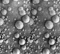
After I understood that, I couldn't help but wonder why we didn't see at least a few of these things tipped over to better reveal that shape. I went back to the original MIs and noticed that several of them captured overlapping areas, thus providing some pretty nice stereoscopic image pairs of at least some of them. I made an anaglyph of the best pair I found, put it next to a similar MI anaglyph NASA/JPL created of some berries at Eagle crater for comparison. I know some of you prefer the side-by-side stereopairs, so I will try to post them as well, or in a following message if they both cannot fit below the forum limit. I think the second is a parallel image pair, so you may need to reverse them if you prefer to view them in crosseyed mode. I am using the excellent program StereoPhotoMaker that was recommended by another member here, and I think I haven't yet learned to force it to make a crossseyed pair. I think these things we are seeing here appear pretty spherical in 3D, and quite similar to those we saw in Eagle crater. I'd like to hear what other people think, to make sure I am not deceiving myself.
-------------------- ...Tom
I'm not a Space Fan, I'm a Space Exploration Enthusiast. |
||
|
|
|
||
|
Sep 12 2006, 11:15 AM
Post
#83
|
|
|
Senior Member Group: Members Posts: 2998 Joined: 30-October 04 Member No.: 105 |
That is what is puzzling about the larger "Hershey's Kiss" spherules. They seem to be oriented in mostly the same direction (point up) and from the very subtle shadows I have the impression they are faceted (ie, quasi-pyramidal more than conical). Therefore, I was initially thinking wind-created venifacts formed in-place instead of tectite-oid features falling and orienting by chance.
I dunno, let me look closer at the "faceted" issue. And after all, we are looking at a sample of a few spherules out of millions. And I'd like to get MB reading to see which spherules are basaltic and which are hematitic. Any ideas about the rocks exposed in Emma Dean? I keep hoping for a closer look... --Bill -------------------- |
|
|
|
|
Sep 12 2006, 12:05 PM
Post
#84
|
|
|
Member Group: Members Posts: 910 Joined: 4-September 06 From: Boston Member No.: 1102 |
If the "Hershey's Kiss" spherules are all pointing up, wouldn't that imply that the soil has never been mixed? Their shape is not so Hershey's Kiss like that they would sort to sit on their bottoms?
-------------------- |
|
|
|
|
Sep 12 2006, 12:27 PM
Post
#85
|
|
 Junior Member Group: Members Posts: 57 Joined: 17-May 06 From: Houston, Texas Member No.: 776 |
QUOTE (Floyd @ Sep 12 2006, 07:05 AM) If the "Hershey's Kiss" spherules are all pointing up, wouldn't that imply that the soil has never been mixed? Their shape is not so Hershey's Kiss like that they would sort to sit on their bottoms? Perhaps they are blueberries that have been sitting on the surface so long, wind has eroded their tops into that shape. -------------------- |
|
|
|
|
Sep 12 2006, 05:02 PM
Post
#86
|
||
 Member Group: Members Posts: 239 Joined: 20-April 05 From: Bruxelles, Belgium Member No.: 278 |
CAHVOR color projection L257
R = 80% L2 + 20% L7 G = 100% L5 B = 80% L7
-------------------- |
|
|
|
|
|
|
Sep 12 2006, 05:05 PM
Post
#87
|
||
|
Member Group: Members Posts: 239 Joined: 20-April 05 From: Bruxelles, Belgium Member No.: 278 |
R = 100% L2
G = 100% L5 B = 100% L7
-------------------- |
|
|
|
|
|
|
Sep 12 2006, 07:21 PM
Post
#88
|
|
 Senior Member Group: Members Posts: 1619 Joined: 12-February 06 From: Bergerac - FR Member No.: 678 |
Wow! Delicious colors on the first pic Indian3000, I love it.

-------------------- |
|
|
|
|
Sep 13 2006, 04:37 PM
Post
#89
|
||
|
Senior Member Group: Members Posts: 1619 Joined: 12-February 06 From: Bergerac - FR Member No.: 678 |
I made a crossed-eyes (or parallel
 what is the difference between this two?) animation from Sol 917 navcan pictures. what is the difference between this two?) animation from Sol 917 navcan pictures.
Attached thumbnail(s)
-------------------- |
|
|
|
|
|
|
Sep 13 2006, 04:44 PM
Post
#90
|
|
|
Member Group: Members Posts: 242 Joined: 17-February 04 From: Ohio, USA Member No.: 34 |
Cosmic
Good job on the anaglyphs of the pebbles. You're right, they do look more spherical thanI had originally thought. Now I'm scratching my head again. I still think the "impact tektite" explanation might work, but it's very conjectural. Indian - good looking colors! |
|
|
|
|
Sep 13 2006, 07:02 PM
Post
#91
|
|
|
Senior Member Group: Members Posts: 2228 Joined: 1-December 04 From: Marble Falls, Texas, USA Member No.: 116 |
Indian3000: That is very nice color, and thanks for giving us your "recipe."
Ant103: A parallel stereo pair is one in which the image for the left eye is on the left, and the image for the right eye is on the right...so your eyes are looking in parallel directions when viewing it. A cross-eyed pair is the the opposite, where the left image is on the right and the right image is on the left...so your eyes must be crossed to view the stereo pair. Gray: Thanks. I am very curious about the ejecta. If they really are going to spend some quality time at Emma Dean, perhaps we'll see it and it's relationship to the soil below the wheels. Like Bill, I too am hoping for a closer look. It would be an anxious wait for us all, but I'm sure it will make it easier to understand what we see when finally at Victoria's rim. -------------------- ...Tom
I'm not a Space Fan, I'm a Space Exploration Enthusiast. |
|
|
|
|
Sep 15 2006, 04:57 AM
Post
#92
|
|
|
Senior Member Group: Members Posts: 2998 Joined: 30-October 04 Member No.: 105 |
Here is an L257 Pancam of what I suppose to be the next IDD target, Cape Faraday. Note the blueberries imbedded in the rock along bedding planes. They are of the "large-size population" and dispell the notion that the large spherules are impact lapilli. They represent a new member of the size and morphological distribution of the hematite concretions. I suspect that these larger blueberries are from a lower horizon of the evaporite unit unheretofore exposed, and which was brought to the surface by the Victoria impact.
I'm looking forward to setting our CCDs on the reddish and purple-tinged and rough-textured rocks we see in Emma Dean. Victoria will still be there in a few Sols... --Bill -------------------- |
|
|
|
|
Sep 15 2006, 05:48 AM
Post
#93
|
||
 The Poet Dude Group: Moderator Posts: 5551 Joined: 15-March 04 From: Kendal, Cumbria, UK Member No.: 60 |
Nice berries...
-------------------- |
|
|
|
|
|
|
Sep 15 2006, 06:25 PM
Post
#94
|
|
 Junior Member Group: Members Posts: 39 Joined: 5-June 06 Member No.: 803 |
JPL just released this (rather grainy) photo of a 30km crater on Titan.
The apron of ejecta surrounding it immediately reminded me of Victoria. Perhaps these sharp-edged blankets are a common feature of craters forming in saturated soils, within an atmosphere. (Of course, the fluid on Titan is a hydrocarbon mix, and the atmosphere mostly nitrogen). Full post here. |
|
|
|
|
Sep 15 2006, 06:51 PM
Post
#95
|
|
|
Member Group: Members Posts: 290 Joined: 26-March 04 From: Edam, The Netherlands Member No.: 65 |
QUOTE (Stu @ Sep 15 2006, 05:48 AM) Nice berries... Seems to me the closer we get to craters, the " berrieer" (more and more spherical) it gets. Could craters and berries be related ? |
|
|
|
|
Sep 15 2006, 09:02 PM
Post
#96
|
|
 Member Group: Members Posts: 160 Joined: 4-July 05 From: Huntington Beach, CA, USA Member No.: 429 |
QUOTE (Marcel @ Sep 15 2006, 02:51 PM) Seems to me the closer we get to craters, the " berrieer" (more and more spherical) it gets. Could craters and berries be related ? Apparently, the crater ejecta is eroded exposing the berries. The ejecta is fractured by the impact and thus easier to erode. Also, the dust is blown back to the crater, exposing the surface to the faster dust particles during the storms until there are enough berries on top of the rocks to protect them from further erosion. |
|
|
|
|
Sep 15 2006, 09:29 PM
Post
#97
|
|
 Senior Member Group: Moderator Posts: 3233 Joined: 11-February 04 From: Tucson, AZ Member No.: 23 |
QUOTE (CryptoEngineer @ Sep 15 2006, 11:25 AM) Perhaps these sharp-edged blankets are a common feature of craters We've also seen such "pedestal" craters on Saturn's moon Dione, a world without an atmosphere or saturated near-surface.
forming in saturated soils, within an atmosphere. (Of course, the fluid on Titan is a hydrocarbon mix, and the atmosphere mostly nitrogen). -------------------- &@^^!% Jim! I'm a geologist, not a physicist!
The Gish Bar Times - A Blog all about Jupiter's Moon Io |
|
|
|
|
Sep 17 2006, 12:43 AM
Post
#98
|
|
|
Senior Member Group: Members Posts: 2998 Joined: 30-October 04 Member No.: 105 |
Here is an MI of part of the Cape Faraday rock from Sol 939. An interesting texture has been eroded onto the rock, which shows the evaporite in vertical cross-section and not the usual bedding plane section. I may be wrong, but there seems to be the light-toned evaporite dust adhering to one side of the blueberries. I don't know if this is on the downwind side of the spherules or has accumulated on the upwind. I'm not sure of the rover orientation (I think that the target rock is to the NE of Emma Dean), and the MI image is presented un-inverted so that it matches the Pancam planning image.
--Bill -------------------- |
|
|
|
|
Sep 17 2006, 06:16 AM
Post
#99
|
|
|
Senior Member Group: Members Posts: 3419 Joined: 9-February 04 From: Minneapolis, MN, USA Member No.: 15 |
The "Hershey's kiss" berries in this MI view are not only conical, the cones are slightly faceted. However, I still have a hard time believing that this is due to aeolian erosion.
My main objection to this being aeolian erosion is that, if these kisses are hematitic concretions that have been eroded out of evaporite from Victoria ejecta, they ought to have been emplaced on the surface (and thus exposed to winds) *after* some, if not most, of the blueberries out on the plains. All other things being equal, the berries on the plains, having been exposed to winds for a longer period of time, ought to display a greater degree of erosional faceting. They don't. In fact, the blueberries seen in the soils out on the plains (and in both Eagle and Endurance, for that matter) were remarkably spherical. I don't remember seeing a single concretion, up until this last series of MIs in the Victoria ejecta, which displayed obvious ventifact forms. These are the very first examples of this type of morphology in the blueberries (if that's what they are) that I can recall. Of course, the key to the above statement is "all other things being equal." If these are acutally hematitic concretions, they would seem to have eroded out of Victoria ejecta made up of concretion-bearing evaporite, correct? But evaporite emplaced this close to the rim of a crater this big must have been awfully shocked. What do berries which erode out of *highly shocked* evaporite look like? Maybe they look like Hershey's kisses... One thing bothers me, though. We're only 120 meters away from the rim of a crater that was created in an enormous translation of kinetic energy into thermal energy. It was big enough to dig a crater that was, originally, probably at least a half a kilometer wide and several hundred meters deep. I have a hard time imagining how the ejecta emplaced only a couple of hundred meters, at most, away from the edge of the hole made by this powerful explosion could have been so relatively unaltered that it would look even remotely like the evaporite we saw out on the plains. If, in fact, these berries are hematitic concretions which formed exactly the same way those out on the plains formed, and if they were originally formed in the target rock into which the Victoria impactor struck, why have so many of them survived seemingly intact (if mysteriously eroded into little cones)? And if the "kisses" are the same size as the concretions we saw out on the plains, then what are the mostly spherical bodies which, except for size, closely resemble the mostly-spherical plains berries? Are these also concretions? If so, why are they fairly uniform in size but only a fraction the size of the plains concretions? And if the kisses and smaller, rounder bodies are both concretions, why do they both exist? We're not seeing spectrum of sizes, here, that would suggest the result of erosional or shock processes -- we're seeing a small population of kisses, and much larger population of fairly uniformly-sized smaller, rounded bodies. Such a neat division of populations suggests differences not in erosional processes, but in formative processes. And in composition. In other words, I think it makes more sense to assume that the kisses and the small spheres have different compositions and/or formation histories. Ah, but if only one of these two populations is made up of hematitic concretions, which one is it? Perhaps there is a clue in this most recent MI image -- there is a feature in the dust "above" the rock face that looks rather like a worm. But this 'worm' is exactly the same size, in planform, as the small spheres. It resembles the small spheres in almost all respects, except that it is a drawn-out blob instead of a spherical blob. Perhaps this would suggest that it is the small spheres that were once molten? I can visualize a spray of impact melt droplets solidifying into spheres in the very thin air as they flew out of the crater (not enough air pressure to compress them into teardrop shapes), and that while most of them fell as individual, rounded drops, some of them would hit each other in mid-air and form into, among other forms, chains of drops that ended up looking like tiny little worm-forms. In other words, could the small spheres be the impact melt we've been looking for? One last thing -- this all assumes that the annulus we see around Victoria is primarily the erosional remnants of her ejecta blanket. However, if Victoria is indeed a once-covered-over crater that has been (or is being) exhumed, then the soil we're looking at maybe doesn't incorporate much at all from the original ejecta. Maybe we're just looking at the erosional remnants of the materials that covered Victoria, and its actual ejecta blanket is still buried and inaccessible to our eyes? Of course, if that's the case, you would expect these soils to look exactly like any other patch of blueberry-paving in Meridiani, and it most definitely looks different from the plains soils. So I tend to discard the once-buried-now-exhumed crater theory. (Besides, it looks like a sharp, fresh crater -- most of the exhumed craters I've seen on Mars look far older and more eroded than this.) Well, that's my two cents worth, anyway... -the other Doug -------------------- The trouble ain't that there is too many fools, but that the lightning ain't distributed right. -Mark Twain
|
|
|
|
|
Sep 17 2006, 06:42 AM
Post
#100
|
|
 The Insider Group: Members Posts: 669 Joined: 3-May 04 Member No.: 73 |
QUOTE (dvandorn @ Sep 16 2006, 11:16 PM) Perhaps this would suggest that it is the small spheres that were once molten? I can visualize a spray of impact melt droplets solidifying into spheres in the very thin air as they flew out of the crater (not enough air pressure to compress them into teardrop shapes), and that while most of them fell as individual, rounded drops, some of them would hit each other in mid-air and form into, among other forms, chains of drops that ended up looking like tiny little worm-forms. In other words, could the small spheres be the impact melt we've been looking for? Interesting, but there is one piece of evidence that shoots this down. The perfectly spherical hematite spherules were found embedded between various layers of bedrock at Eagle and Endurance. This can't be explained by impact melt since the spherules were still in their original strata. |
|
|
|
 |

|
Lo-Fi Version | Time is now: 19th May 2024 - 06:41 PM |
|
RULES AND GUIDELINES Please read the Forum Rules and Guidelines before posting. IMAGE COPYRIGHT |
OPINIONS AND MODERATION Opinions expressed on UnmannedSpaceflight.com are those of the individual posters and do not necessarily reflect the opinions of UnmannedSpaceflight.com or The Planetary Society. The all-volunteer UnmannedSpaceflight.com moderation team is wholly independent of The Planetary Society. The Planetary Society has no influence over decisions made by the UnmannedSpaceflight.com moderators. |
SUPPORT THE FORUM Unmannedspaceflight.com is funded by the Planetary Society. Please consider supporting our work and many other projects by donating to the Society or becoming a member. |
|